Participatory Land use planning and assessment [ຕາຈິກິສະຕານ]
- ການສ້າງ:
- ປັບປູງ:
- ຜູ້ສັງລວມຂໍ້ມູນ: Askarsho Zevarshoev
- ບັນນາທິການ: –
- ຜູ້ທົບທວນຄືນ: Farrukh Nazarmavloev
Накшаи муштараки истифодабари ва бахогузории замин
approaches_3635 - ຕາຈິກິສະຕານ
ເບິ່ງພາກສ່ວນ
ຂະຫຍາຍທັງໝົດ ຍຸບທັງໝົດ1. ຂໍ້ມູນທົ່ວໄປ
1.2 ລາຍລະອຽດ ການຕິດຕໍ່ ຂອງບຸກຄົນທີ່ຊັບພະຍາກອນ ແລະ ສະຖາບັນ ການມີສ່ວນຮ່ວມ ໃນການປະເມີນຜົນ ແລະ ເອກະສານ ຂອງວິທີທາງ
ຊື່ຂອງໂຄງການ ທີ່ອໍານວຍຄວາມສະດວກ ໃນການສ້າງເອກກະສານ ຫຼື ປະເມີນດ້ານແນວທາງ (ຖ້າກ່ຽວຂ້ອງ)
Integrated Health and Habitat Improvement in Rasht Valley, Tajikistanຊື່ຂອງ ສະຖາບັນການຈັດຕັ້ງ ທີ່ອໍານວຍຄວາມສະດວກ ໃນການສ້າງເອກກະສານ ຫຼື ປະເມີນແນວທາງ (ຖ້າກ່ຽວຂ້ອງ)
Aga Khan Foundation (AKF) - ສະວິດເຊີແລນ1.3 ເງື່ອນໄຂ ຂອງການນໍາໃຊ້ເອກກະສານຂໍ້ມູນ ຂອງ WOCAT
ເມື່ອໃດທີ່ໄດ້ສັງລວມຂໍ້ມູນ (ຢູ່ພາກສະໜາມ)?
25/07/2017
ຜູ້ສັງລວມ ແລະ ບັນດາຜູ້ຕອບແບບສອບຖາມ ຍອມຮັບໃນເງື່ອນໄຂ ການນໍາໃຊ້ຂໍ້ມູນເອກະສານ ທີ່ສ້າງຂື້ນ ໂດຍຜ່ານ ອົງການ WOCAT:
ແມ່ນ
1.4 ເອກະສານອ້າງອີງ (ຫຼາຍ) ກັບແບບສອບຖາມ (ຫຼາຍ) ເຕັກໂນໂລຢີ ຂອງດ້ານການຄຸ້ມຄອງ ດິນແບບຍືນຍົງ
2. ພັນລະນາ ແນວທາງການຄຸ້ມຄອງນໍາໃຊ້ດິນແບບຍືນຍົງ
2.1 ການອະທິບາຍ ໂດຍຫຍໍ້ ຂອງວິທີທາງ
Participatory Land Use Planning and Assessment is an inter disciplinary approach to the land use with combination of the modern tools and community knowledge to identify land degradations with its intensity and trends and through this approach design intervention directed toward land degradation prevention. This approach also compiles different tools including PRA and soil assessment and LADA techniques in a participatory manner. The approach address issues with all categories of land use including crop and pasture land, forest and even settlement with regards to natural disaster consideration for construction.
2.2 ການອະທິບາຍ ລາຍລະອຽດ ຂອງວິທີທາງ
ການອະທິບາຍ ລາຍລະອຽດ ຂອງວິທີທາງ:
As a precondition to the development of evidence- and needs-based plans, Participatory Land Use Planning and Assessment (PLUPA) will be conducted, with participation of local specialists, to assess sub-watershed natural and human-induced hazards and natural resource conditions, and IHA results will be presented to community and local government stakeholders to foster ownership. The outcome will improve community involvement in development by enhancing the ability to conduct local development planning and implementation.
Attention will be given to promoting the role of women in local development.
The PLUPA will employ terrestrial inspection of the land using simplified tools based on the WOCAT questionnaire for the land management technologies. The field-based assessment will include physical inspection of the land use and collecting necessary data like GPS points and information on target watershed (e.g. availability of pastureland, natural hazards, public and private infrastructure). The remote sensing component will be used for analyzing images and identification of trend analysis as well erosion on soil, land degradation.
Communities (via CSOs) and local governments are involved in conducting PLUPA, and will drive and own the result for development of their plan at watershed level. They will also be core stakeholders in the prioritization of water, health, and NRM interventions as per watershed management plan, and will be partners and contributors (including financially) in construction and management of new infrastructure post-project. This fosters commitment and ownership, promoting development that is accountable, participatory, inclusive, transparent, and efficient.
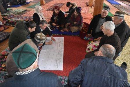
2.3 ຮູບພາບຂອງແນວທາງ
ສື່ຮູບພາບ
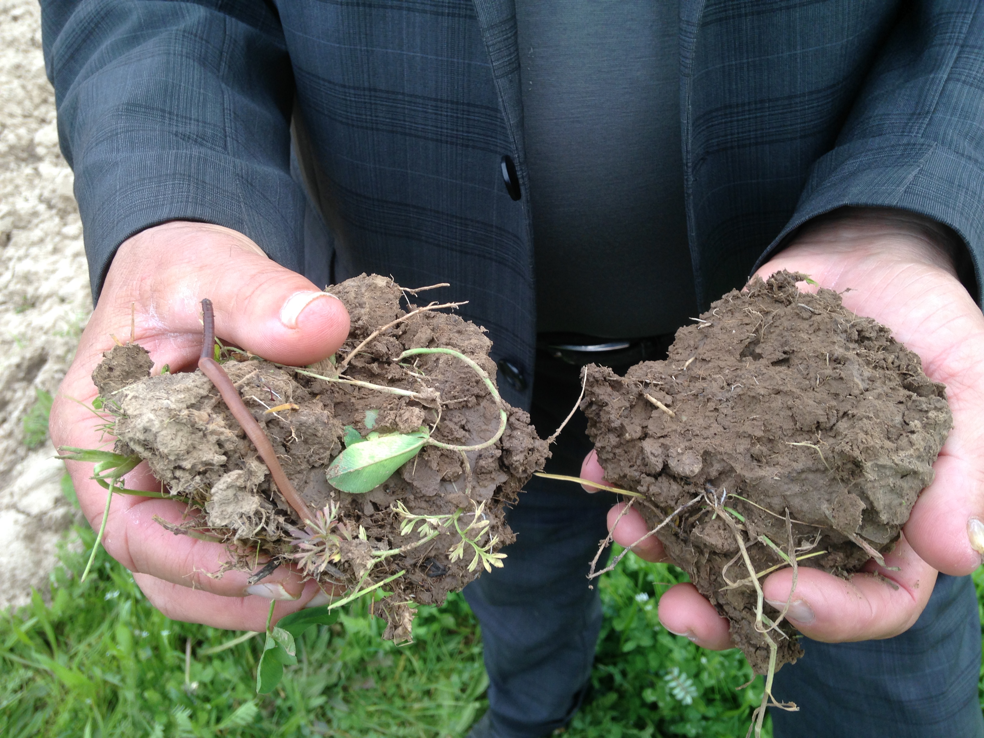
ຂໍ້ສັງເກດໂດຍທົ່ວໄປກ່ຽວກັບການຮູບພາບ:
Two sample of soils from one plot where the land used for different purposes
2.5 ປະເທດ / ເຂດ / ສະຖານທີ່ບ່ອນທີ່ແນວທາງໄດ້ຖືກນໍາໃຊ້
ປະເທດ:
ຕາຈິກິສະຕານ
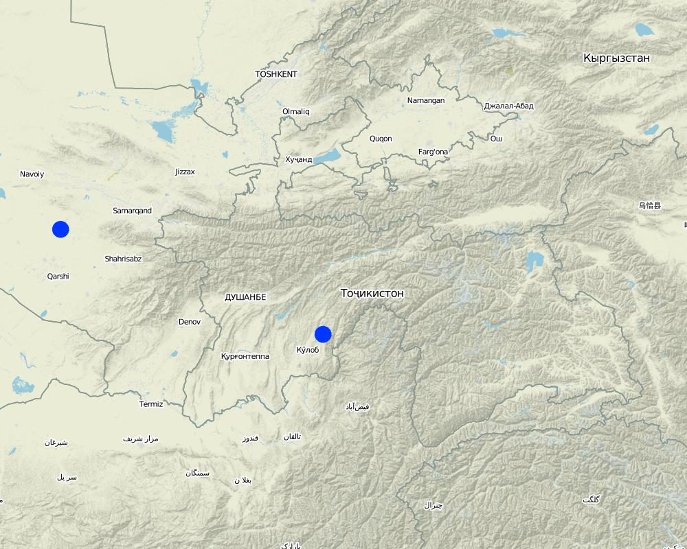
Map
×2.6 ວັນທີເລີ່ມຕົ້ນ ແລະ ສິ້ນສຸດ ການຈັດຕັ້ງປະຕີບັດ ວິທີທາງ
ຖ້າຫາກບໍ່ຮູ້ຈັກປີທີ່ແນ່ນອນ, ໃຫ້ປະມານຄາດຄະເນ ເອົາມື້ທີ່ໄດ້ເລີ່ມຈັດຕັ້ງປະຕິບັດ ວິທີທາງ:
ຕໍ່າກວ່າ 10 ປີ ຜ່ານມາ (ມາເຖິງປະຈຸບັນ)
2.7 ປະເພດຂອງແນວທາງ
- ພາຍໃຕ້ໂຄງການ / ແຜນງານ
2.8 ເປົ້າໝາຍ / ຈຸດປະສົງຫຼັກ ຂອງການຈັດຕັ້ງປະຕິບັດ ວິທີທາງ
The main goal of the approach is to bring together stakeholders to use simplified methods on soil assessment and raise awareness on the importance of soil health for production. Based on that approach communities will design action for better management of their land and soil conservaiton
2.9 ເງື່ອນໄຂອໍານວຍ ຫຼື ຂັດຂວາງການປະຕິບັດຂອງເຕັກໂນໂລຢີ / ເຕັກໂນໂລຢີການນໍາໃຊ້ຕາມແນວທາງ
ສັງຄົມ / ວັດທະນະທໍາ / ມາດຕະຖານ ແລະ ຄຸນຄ່າທາງສາສະໜາ
- ເຊື່ອງຊ້ອນ
people are not organized well and land use planning is taking place on a add-hoc basis. traditional knowledge, which is bind to local culture and social norms is lost with applying pre-modern agriculture practice for what community does not have proper access to resources, such as inputs and tehcnology
ການກໍ່ຕັ້ງສະຖາບັນ
- ອໍານວຍ
ກ່ຽວກັບກົດໝາຍ (ສິດນໍາໃຊ້ດິນ, ສິດນໍາໃຊ້ນໍ້າ)
- ອໍານວຍ
farmers are organized in a legal structure, which is make them compliant to the land rights and supported with planning for land use
ຄວາມຮູ້ກ່ຽວກັບການຄຸ້ມຄອງ ທີ່ດິນແບບຍືນຍົງ, ການເຂົ້າເຖິງການສະໜັບສະໜູນ ທາງດ້ານວິຊາການ
- ເຊື່ອງຊ້ອນ
not all farmers, which got land have farming knowledge and practices on SLM. Basic practices which they learn from other farmer or inherited from their generation.
ຕະຫຼາດ (ໃນການຊື້ວັດຖຸດິບ, ຂາຍຜະລິດຕະພັນ) ແລະ ລາຄາ
- ອໍານວຍ
there is a lot of demand for food products in the markets and existing service providers who supply inputs. If land use planning is organized in a good way community will get good benefit from farming.
3. ການມີສ່ວນຮ່ວມ ແລະ ບົດບາດຂອງພາກສ່ວນທີ່ກ່ຽວຂ້ອງທີ່ໄດ້ມີສ່ວນຮ່ວມ
3.1 ຜູ້ມີສ່ວນຮ່ວມ ໃນວິທີທາງ ແລະ ພາລະບົດບາດ ຂອງເຂົາເຈົ້າ
- ຜູ້ນໍາໃຊ້ດິນໃນທ້ອງຖິ່ນ / ຊຸມຊົນທ້ອງຖິ່ນ
land users, forest user, pasture users,
plan and provide field based knowledge on land use practices
- ອົງການຈັດຕັ້ງ ພາຍໃນຊຸມຊົນ
village organization and different initiative groups with regards to land use
support with mobilizing communities for better planning of the land resource and motivate collaboration between different land users
- ຜູ້ຊ່ຽວຊານ ການນຄຸ້ມຄອງ ທີ່ດິນແບບຍືນຍົງ / ທີ່ປຶກສາດ້ານກະສິກໍາ
land management, forest, pasture specialist from related department of government
support with providing technical knowledge and solving the current land use issues with applying/providing good practices
- ອໍານາດ ການປົກຄອງທ້ອງຖິ່ນ
sub-district and district level
facilitate the process of collaboration among different land users and make decision on future perspective of land use
3.2 ການມີສ່ວນຮ່ວມຂອງຜູ້ນໍາໃຊ້ທີ່ດິນໃນທ້ອງຖິ່ນ / ຊຸມຊົນທ້ອງຖິ່ນໃນໄລຍະທີ່ແຕກຕ່າງກັນຂອງແນວທາງ
| ການລວບລວມ ເອົາຜູ້ນໍາໃຊ້ດິນ ໃນທ້ອງຖິ່ນ / ຊຸມຊົນທ້ອງຖິ່ນ | ໃຫ້ລະບຸ ຜູ້ໃດທີ່ມີສ່ວນຮ່ວມ ໃນແຕ່ລະກິດຈະກໍາ? | |
|---|---|---|
| ການເລີ່ມຕົ້ນ / ແຮງຈູງໃຈ | ການຊ່ວຍເຫຼືອຈາກພາຍນອກ | land users of different categories, including pasture users, forest user etc,. come together to discuss the future land use perspective and decide on organizing themselves in better management of their land resources |
| ການວາງແຜນ | ການຮ່ວມມື | all stakeholders involved and support different perspective of land use categories and jointly plan for the future land use |
| ການປະຕິບັດ | ການຊ່ວຍເຫຼືອຈາກພາຍນອກ | all stakeholders, involved in different land use categories negotiate and agree on terms and condition with regards complement the different land use importance. |
| ຕິດຕາມກວດກາ / ການປະເມີນຜົນ | ການບໍ່ປະຕິບັດ | all stakeholders are passive in following the progress and results from land use intervention. |
3.4 ການຕັດສິນໃຈກ່ຽວກັບການຄັດເລືອກເຕັກໂນໂລຢີຂອງການຄຸ້ມຄອງທີ່ດິນແບບຍືນຍົງ / ເຕັກໂນໂລຢີ
ລະບຸ ຄົນທີ່ຕັດສິນໃຈ ກ່ຽວກັບການຄັດເລືອກຂອງ ເຕັກໂນໂລຢີ / ເຕັກໂນໂລຢີ ຈະໄດ້ຮັບການປະຕິບັດ:
- ຜູ້ຊ່ຽວຊານ ຫຼັກດ້ານການຄຸ້ມຄອງ ທີ່ດິນແບບຍືນຍົງ, ມີການຕິດຕາມປຶກສາຫາລືກັບຜູ້ນໍາໃຊ້ທີ່ດິນ
ອະທິບາຍ:
the approach is introduced in the framework of the projects and only SLM specialists consult on the tools and approach how to plan
Specify on what basis decisions were made:
- ປະເມີນເອກກະສານ ຄວາມຮູ້ກ່ຽວກັບ ການຄຸ້ມຄອງ ທີ່ດິນແບບຍືນຍົງ (ຫຼັກຖານທີ່ຊ່ວຍໃນການຕັດສິນໃຈ)
4. ການສະໜັບສະໜູນທາງດ້ານວິຊາການ, ການສ້າງຄວາມສາມາດ, ແລະ ການຈັດການຄວາມຮູ້.
4.1 ການສ້າງຄວາມສາມາດ / ການຝຶກອົບຮົມ
ຜູ້ນໍາໃຊ້ທີ່ດິນ ຫຼື ພາກສ່ວນກ່ຽວຂ້ອງອື່ນໆ ໄດ້ຮັບການຝຶກອົບຮົມບໍ່?
ແມ່ນ
ໃຫ້ລະບຸ ຜູ້ໃດທີ່ໄດ້ຮັບການຝຶກອົບຮົມ:
- ຜູ້ນໍາໃຊ້ດິນ
- ພະນັກງານພາກສະໜາມ / ທີ່ປຶກສາ
ຖ້າເປັນໄປໄດ້, ໃຫ້ລະບຸເພດ, ອາຍຸ, ສະຖານະພາບ, ຊົນເຜົ່າ, ແລະ ອື່ນໆ:
training on soil assessment, land management and participatory land use planning and assessment
ຮູບແບບຂອງການຝຶກອົບຮົມ:
- ການເຮັດຕົວຈິງ
- ກອງປະຊຸມ
ໃນຫົວຂໍ້:
land degradation, soil assessment, land management
4.2 ການບໍລິການໃຫ້ຄໍາປຶກສາ
ເຮັດຜູ້ໃຊ້ທີ່ດິນມີການເຂົ້າເຖິງການບໍລິການໃຫ້ຄໍາປຶກສາ?
ບໍ່ແມ່ນ
4.3 ສະຖາບັນການສ້າງຄວາມເຂັ້ມແຂງ (ການພັດທະນາອົງການຈັດຕັ້ງ)
ສະຖາບັນ ໄດ້ຮັບການສ້າງຕັ້ງຂື້ນ ຫຼື ໄດ້ຮັບການສ້າງຄວາມເຂັ້ມແຂງ ໂດຍການຈັດຕັ້ງປະຕິບັດ ວິທີທາງບໍ່?
- ມີ, ໜ້ອຍໜຶ່ງ
ລະບຸ ທາງສະຖາບັນ ໄດ້ສ້າງຄວາມເຂັ້ມແຂງ ໃນລະດັບໃດ (ຫຼາຍ):
- ທ້ອງຖິ່ນ
ອະທິບາຍ ສະຖາບັນການຈັດຕັ້ງ, ພາລະບົດບາດ ແລະ ໜ້າທີ່ຮັບຜິດຊອບ, ສະມາຊິກ ແລະ ອື່ນໆ.
land use committee under the village organization as small entity dealing with land issues in the community only
ລະບຸ ປະເພດ ຂອງສະໜັບສະໜູນ:
- ການສ້າງຄວາມອາດສາມາດ / ການຝຶກອົບຮົມ
ໃຫ້ລາຍລະອຽດເພີ່ມເຕີມ:
land management, land degradation prevention
4.4 ຕິດຕາມກວດກາ ແລະ ປະເມີນຜົນ
ການຈັດຕັ້ງປະຕິບັດ ວິທີທາງ ໄດ້ມີການປະເມີນຜົນ ແລະ ຕິດຕາມບໍ?
ບໍ່ແມ່ນ
4.5 ການຄົ້ນຄວ້າ
ນີ້້ແມ່ນສ່ວນໜຶ່ງ ການຄົ້ນຄວ້າ ຂອງວິທີທາງບໍ່?
ບໍ່ແມ່ນ
5. ການສະໜັບສະໜູນທາງດ້ານການເງິນ ແລະ ອຸປະກອນຈາກພາຍນອກ
5.1 ງົບປະມານປະຈໍາປີ ສໍາລັບວິທີທາງ ຂອງການຄຸ້ມຄອງ ທີ່ດິນແບບຍືນຍົງ
ຖ້າຫາກບໍ່ຮູ້ຈັດງົບປະມານທີ່ແນ່ນອນ ແມ່ນໃຫ້ປະມານເອົາ:
- < 2,000
5.2 ການສະໜັບສະໜູນ ທາງດ້ານການເງິນ / ອຸປະກອນ ສະໜອງໃຫ້ແກ່ຜູ້ນໍາທີ່ດິນ
ຜູ້ນໍາໃຊ້ດິນ ໄດ້ຮັບການສະໜັບສະໜູນ ທາງດ້ານ ການເງິນ / ອຸປະກອນ ໃນການຈັດຕັ້ງປະຕິບັດ ເຕັກໂນໂລຢີບໍ?
ບໍ່ແມ່ນ
5.3 ເງິນສົມທົບສໍາລັບການນໍາໃຊ້ສະເພາະປັດໃຈຂາເຂົ້າໃນການຜະລີດກະສິກໍາ (ລວມທັງແຮງງານ)
- ບໍ່ມີ
ຖ້າແຮງງານ ຂອງຜູ້ນໍາໃຊ້ດິນ ໄດ້ຮັບການສະໜັບສະໜູນ ປັດໃຈຂາເຂົ້າ, ແມ່ນບໍ່:
- ການອາສາ
5.4 ສິນເຊື່ອ
ໄດ້ປ່ອຍສິນເຊື່ອ ສະໜອງໃຫ້ພາຍໃຕ້ ວິທີການສໍາລັບກິດຈະກໍາ ການຄຸ້ມຄອງ ທີ່ດິນແບບຍືນນຍົງບໍ່?
ບໍ່ແມ່ນ
5.5 ສິ່ງຈູງໃຈ ຫຼື ເຄື່ອງມືອື່ນໆ
ການສົ່ງເສີມ ຈັດຕັ້ງປະຕິບັດ ເຕັກໂນໂລຢີ ໃນການຄຸ້ມຄອງ ດິນແບບຍືນຍົງ ໄດ້ສະໜອງສິ່ງກະຕຸກຊຸກຍູ້ບໍ່?
ແມ່ນ
ຖ້າແມ່ນ, ໃຫ້ລະບຸ:
some funding was made available for implementation of action prioritized in the land use planning
6. ວິເຄາະຜົນກະທົບ ແລະ ສັງລວມບັນຫາ
6.1 ຜົນກະທົບຂອງແນວທາງ
ວິທີທາງ ຊ່ວຍຊຸກຍູ້ ຜູ້ນຳໃຊ້ທີ່ດິນທ້ອງຖີ່ນ, ໃນການປັບປຸງ ການມີສ່ວນຮ່ວມ ຂອງຜູ້ທີ່ກ່ຽວຂ້ອງ ບໍ່?
- ບໍ່
- ມີ, ໜ້ອຍໜຶ່ງ
- ມີ, ພໍສົມຄວນ
- ມີ, ຫຼາຍ
the process follow by series of capacity building trainings, which are empowering community to get knowledge and understanding
ການນໍາໃຊ້ ວິທີທາງ ດັ່ງກ່າວນີ້ ສາມາດເປັນຫຼັກຖານ ທີ່ສະໜັບສະໜູນ ໃຫ້ການຕັດສິນໃຈໄດ້ບໍ່?
- ບໍ່
- ມີ, ໜ້ອຍໜຶ່ງ
- ມີ, ພໍສົມຄວນ
- ມີ, ຫຼາຍ
as the approach involve participatory methods decision is made equally by all stockholders, including land users
ການຈັດຕັ້ງປະຕິບັດ ວິທີທາງ ສາມາດຊ່ວຍຜູ້ນໍາໃຊ້ທີ່ດິນ ໃນການຈັດຕັ້ງປະຕິບັດ ແລະ ບໍາລຸງຮັກສາ ເຕັກໂນໂລຢີ ການຄຸ້ມຄອງ ທີ່ດິນແບບຍືນຍົງໄດ້ບໍ?
- ບໍ່
- ມີ, ໜ້ອຍໜຶ່ງ
- ມີ, ພໍສົມຄວນ
- ມີ, ຫຼາຍ
as a result of the approach action plan with implementing of technologies is involved
ການນໍາໃຊ້ ວິທີທາງ ສາມາດລະດົມ ຫຼື ປັບປຸງ ການເຂົ້າເຖິງຊັບພະຍາກອນ ການເງິນ ສໍາລັບການຈັດຕັ້ງປະຕິບັດ ການຄຸ້ມຄອງ ທີ່ດິນແບບຍືດຍົງໄດ້ບໍ່?
- ບໍ່
- ມີ, ໜ້ອຍໜຶ່ງ
- ມີ, ພໍສົມຄວນ
- ມີ, ຫຼາຍ
the approach results in a sophisticated document as plan and assessment report, which will then attracts funding for easy reference
ການນໍາໃຊ້ ວິທີທາງ ສາມາດຫຼຸດຜ່ອນ ຂໍ້ຂັດແຍ່ງໄດ້ບໍ່?
- ບໍ່
- ມີ, ໜ້ອຍໜຶ່ງ
- ມີ, ພໍສົມຄວນ
- ມີ, ຫຼາຍ
the plan is mobilize communities and other stakeholder to collaborate and work together and negotiate and resolve emerging conflicts over resource
6.2 ແຮງຈູງໃຈຫຼັກຂອງຜູ້ນໍາໃຊ້ທີ່ດິນໃນການປະຕິບັດການຄຸ້ມຄອງທີ່ດິນແບບຍືນຍົງ
- ການຜະລິດເພີ່ມຂຶ້ນ
prevention of and application of technologies contribute to improvement of production
- ຫຼຸດຜ່ອນດິນເຊື່ອມໂຊມ
soil conservation techniques will be identified to apply for prevention of land degradation
6.3 ຄວາມຍືນຍົງຂອງກິດຈະກໍາວິທີທາງ
ຜູ້ນໍາໃຊ້ ທີ່ດິນ ສາມາດສືບຕໍ່ ການຈັດຕັ້ງປະຕິບັດ ຜ່ານວິທີທາງໄດ້ບໍ່ (ໂດຍປາດສະຈາກ ການຊ່ວຍເຫຼືອ ຈາກພາກສ່ວນພາຍນອກ)?
- ບໍ່ແນ່ນອນ
ຖ້າ ບໍ່ ຫຼື ບໍ່ແນ່ໃຈ, ໃຫ້ອະທິບາຍ ແລະ ຄໍາເຫັນ:
community are only focused to get maximum economic benefit from land and therefore do not pay enough attention to support ecosystem services or environmental aspect of land conservation
6.4 ຈຸດແຂງ / ຂໍ້ດີ ຂອງວິທີທາງ
| ຈຸດແຂງ / ຂໍ້ດີ / ໂອກາດໃນການນໍາໃຊ້ທີ່ດິນ |
|---|
| participatory |
| simply approach applied by community members themselve |
| ຈຸດແຂງ / ຈຸດດີ / ໂອກາດ ຈາກທັດສະນະຂອງຜູ້ປ້ອນຂໍ້ມູນ ຫຼື ບຸກຄົນສຳຄັນ |
|---|
| provides visions, empowers land users to negotiate interventions among them, also raise awareness on the sustainability aspects of land use and provides more aspects on land conservation techniques for land term land use |
6.5 ຈຸດອ່ອນ / ຂໍ້ເສຍຂອງແນວທາງ ແລະ ວິທີການແກ້ໄຂໃຫ້ເຂົາເຈົ້າ
| ຈຸດອ່ອນ / ຂໍ້ເສຍ / ຄວາມສ່ຽງໃນມູມມອງຂອງຜູ້ນໍາໃຊ້ທີ່ດິນ | ມີວິທີການແກ້ໄຂຄືແນວໃດ? |
|---|---|
| time consuming, required a lot of facilitation | more awareness on communities knowledge about long term land use benefits. strengthen local legal framework to sustain and promote the planing process |
| ຈຸດອ່ອນ ຫຼື ຂໍ້ເສຍ ຫຼື ຄວາມສ່ຽງ ໃນມຸມມອງຂອງ ຜູ້ສັງລວມຂໍ້ມູນ ຫຼື ບັນດາຜູ້ຕອບແບບສອບຖາມ | ມີວິທີການແກ້ໄຂຄືແນວໃດ? |
|---|---|
| SLM knowledge and capacity | trainings for the local institutes involved in land use planing and management |
7. ເອກກະສານອ້າງອີງ ແລະ ຂໍ້ມູນການເຊື່ອມໂຍງ
7.1 ວິທີການ / ແຫຼ່ງຂໍ້ມູນ
- ການໄປຢ້ຽມຢາມພາກສະໜາມ, ການສໍາຫຼວດພາກສະໜາມ
40
- ສໍາພາດ ຊ່ຽວຊານ ການຄຸ້ມຄອງ ດິນແບບຍືນຍົງ
3
7.2 ເອກະສານທົ່ວໄປທີ່ສາມາດໃຊ້ໄດ້
ຫົວຂໍ້, ຜູ້ຂຽນ, ປີ, ISBN:
Participatory Land Use Planning, 2011
ມີຢູ່ໃສ?ມູນຄ່າເທົ່າໃດ?
Free of charge, from SLM compiler
ຂໍ້ມູນການເຊື່ອມຕໍ່ ແລະ ເນື້ອໃນ
ຂະຫຍາຍທັງໝົດ ຍຸບທັງໝົດການເຊື່ອມຕໍ່
ບໍ່ມີຂໍ້ມູນການເຊື່ອມຕໍ່
ເນື້ອໃນ
ບໍ່ມີເນື້ອໃນ