Integrated Pasture Management Planning in Mountainous Regions [Geórgia]
- Criação:
- Atualização:
- Compilador/a: Hanns Kirchmeir
- Editores: Natia Kobakhidze, Christian Goenner, Jonathan Etzold
- Revisor: Rima Mekdaschi Studer
approaches_5490 - Geórgia
Veja as seções
Expandir tudo Recolher tudo1. Informação geral
1.2 Detalhes do contato das pessoas capacitadas e instituições envolvidas na avaliação e documentação da abordagem
Especialista em GST:
co-compiler:
Especialista em GST:
Nome do projeto que facilitou a documentação/avaliação da Abordagem (se relevante)
Integrated Biodiversity Management, South Caucasus (IBiS)Nome da(s) instituição(ões) que facilitou(ram) a documentação/avaliação da Abordagem (se relevante)
Deutsche Gesellschaft für Internationale Zusammenarbeit (GIZ)1.3 Condições em relação ao uso da informação documentada através de WOCAT
Quando os dados foram compilados (no campo)?
01/02/2016
O compilador e a(s) pessoa(s) capacitada(s) aceitam as condições relativas ao uso de dados documentados através do WOCAT:
Sim
1.4 Referência ao(s) questionário(s) sobre tecnologias da GST
Permanent grass cover in vineyards [Hungria]
Permanent grass cover under grape vines protects the soil surface against erosion and compaction - and provides better conditions for traffic within the rows during mechanised field operations
- Compilador/a: Brigitta Szabó
Remote Sensing as a Tool for Land Degradation … [Geórgia]
Land degradation contributes to biodiversity loss and the impoverishment of rural livelihoods in Tusheti. Above all, however, land degradation are triggered by climate change as traditional land use practise might not be adapted to new climate conditions which can cause or speed up degradation processes significantly. On the other hand, …
- Compilador/a: Hanns Kirchmeir
2. Descrição da abordagem de GST
2.1 Descrição curta da abordagem
The unsustainable use of pastures and forest areas has led to soil erosion, degradation, desertification and loss of biodiversity in the high mountain areas of the South Caucasus. The development of pasture passports is part of a broader approach to a strategic pasture management plan for Tusheti. This showcase includes results from the spatial planning process applied in a pilot programme for Akhmeta municipality.
2.2 Descrição detalhada da abordagem
Descrição detalhada da abordagem:
Project area and purpose
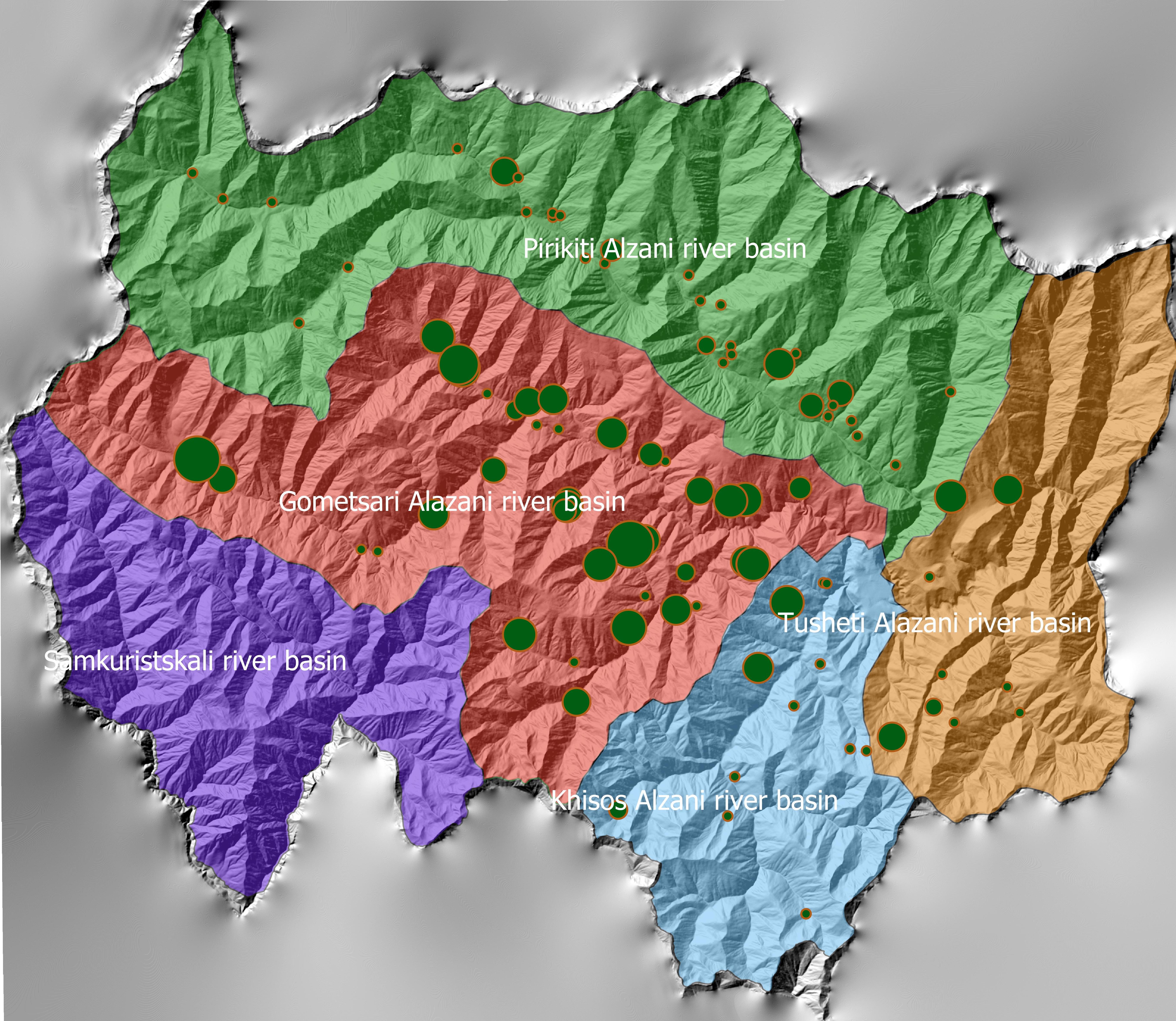
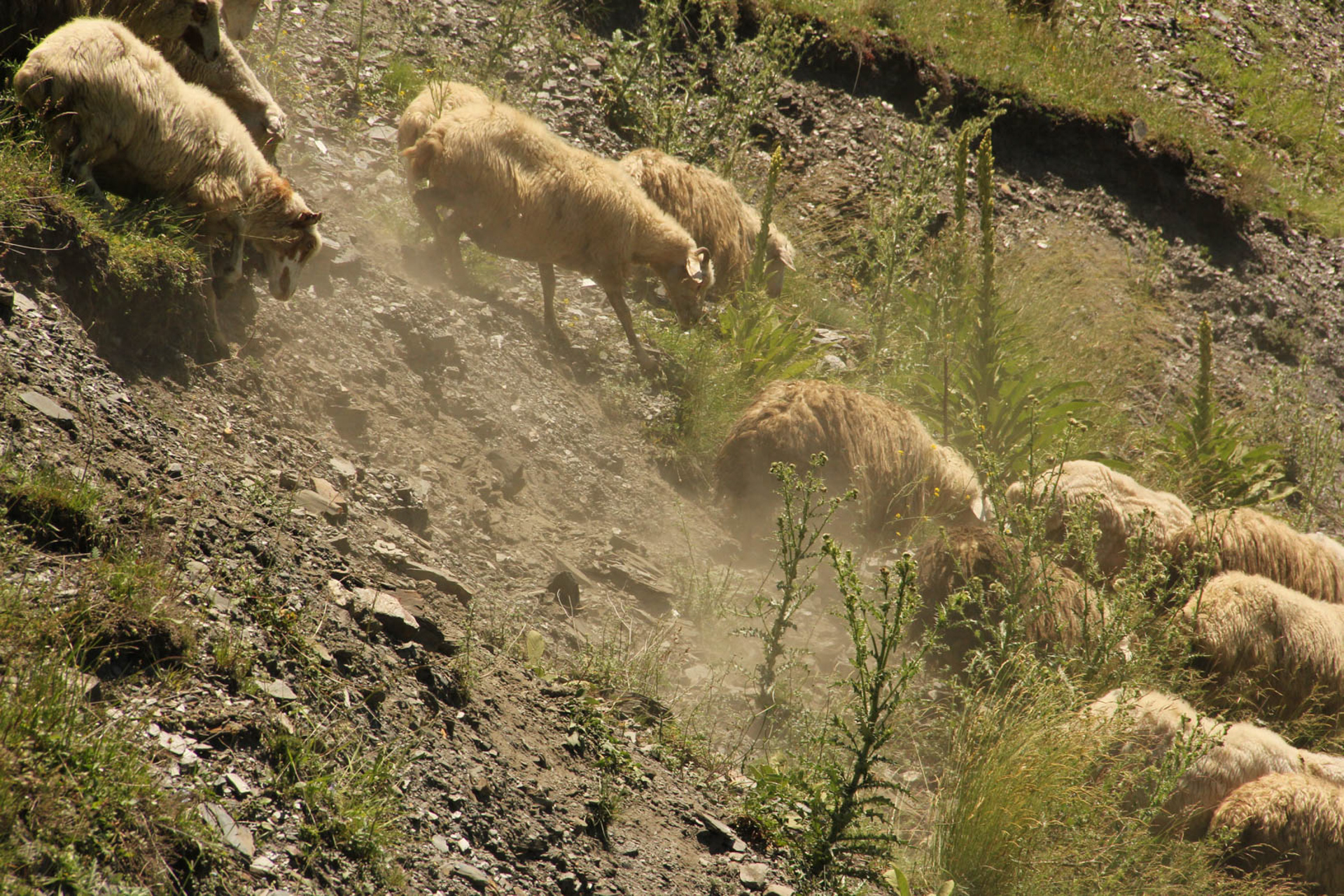
The project area comprises the Tusheti Protected Areas (PAs) on the northern slopes of the Greater Caucasus Mountains in Georgia. This group of protected areas consists of a strict nature reserve, a national park and a protected landscape with about 40 villages and settlements. Together they form a total protected area of approx. 114,000 ha. In Tusheti, overgrazing has led, especially in the eastern part with a higher number of villages and roads, to soil erosion and biodiversity loss. Especially the intensive use of summer pastures during the Soviet period resulted in a severe deterioration of the mountain slopes. So far, there are no standards or guidelines for the elaboration of sustainable pasture management plans in Georgia. Pasture passports, as a first step towards sustainable pasture management, document the actual grazing capacity for each pasture unit and serve as a guiding document for shepherds and local stakeholders and as a basis to prepare lease contracts.
Data gathering
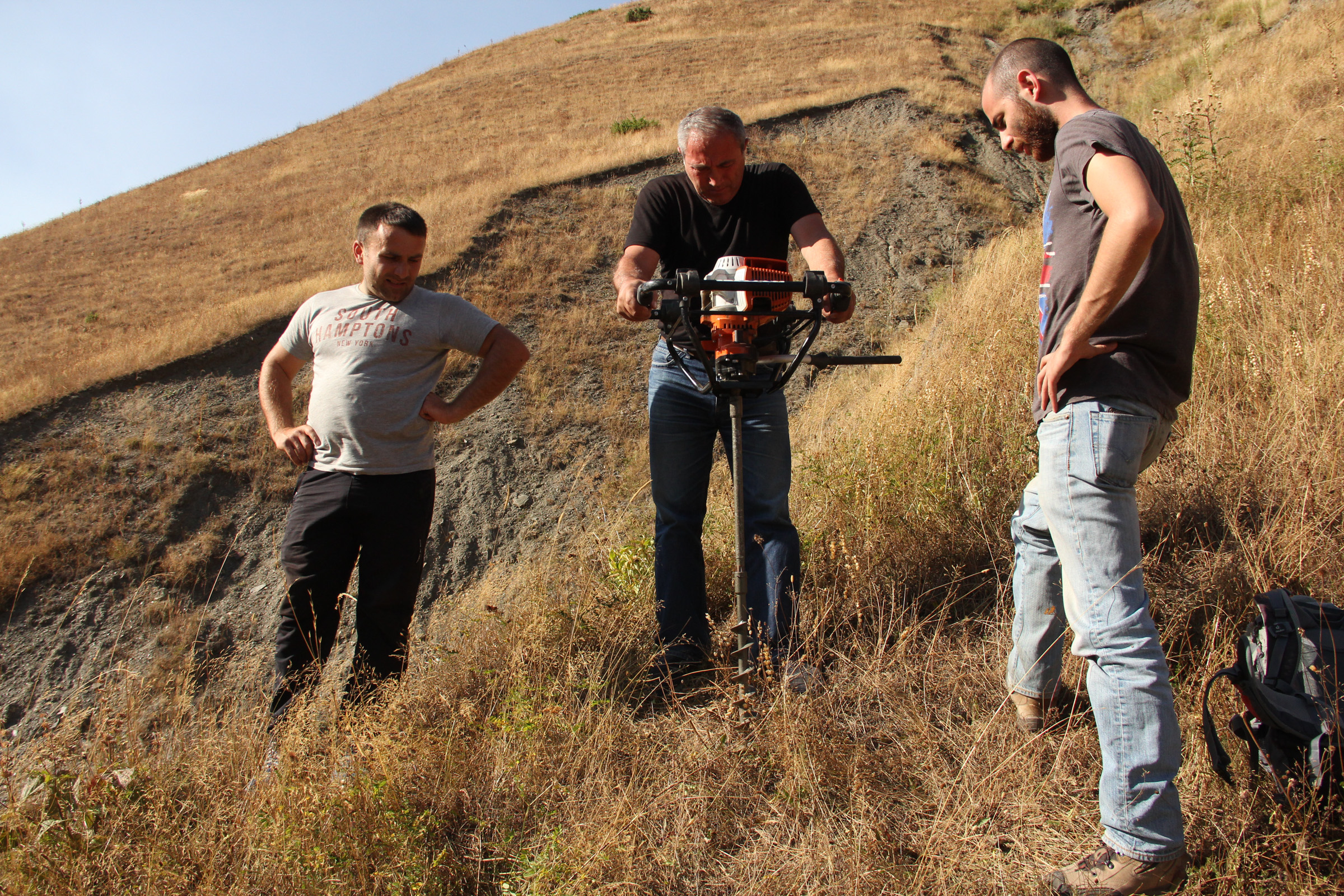
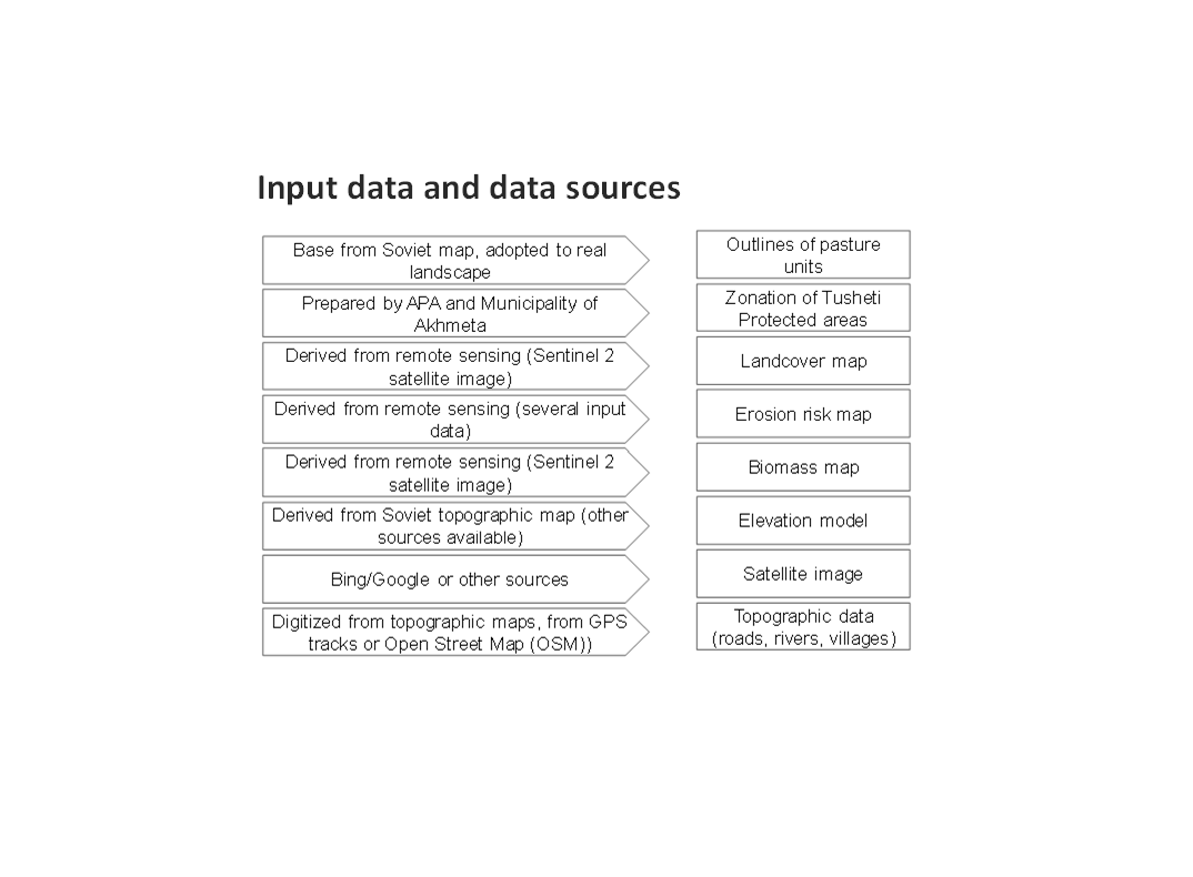
As a prerequisite for the development of pasture passports and the calculation of grazing capacity, the type of land cover, the erosion risk and the biomass of the pastureland had to be assessed for each pasture unit. This was done using remote sensing tools in combination with data collected in the field for calibration.
The details on the methodology of the Land Cover & Biomass as well as the Erosion Risk Assessment can be found in the WOCAT technology on "Remote Sensing as a Tool for Land Degradation Neutrality Monitoring" (see link).
Evaluation and Ground Truthing
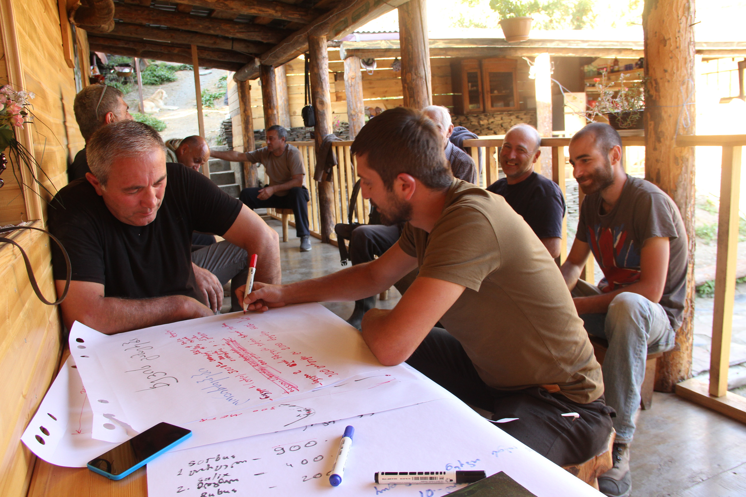
All interim results have been checked and evaluated by local stakeholders, national experts and experts from local administrations. It was important not only to conduct workshops in seminar rooms but to meet the local stakeholders in the field and to discuss the problems and challenges of pasture management on place in the field. At this workshops all levels of decision makers were included (Ministries, Donor organisations, international and national experts, local administrations and land users). This was important to create a common understanding of the current situation from different perspectives (nature conservation, administration, shepherds ...). The combination of remote sensing with calibration data from the field can be summarised as a very effective method to assess the erosion state in large areas. Neither of the two instruments would be able to provide results in this spatial dimension and quality alone.
Pasture Passports
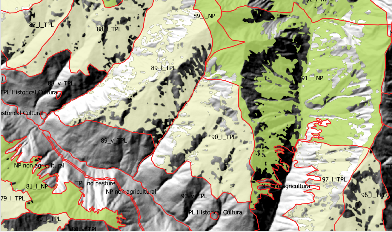
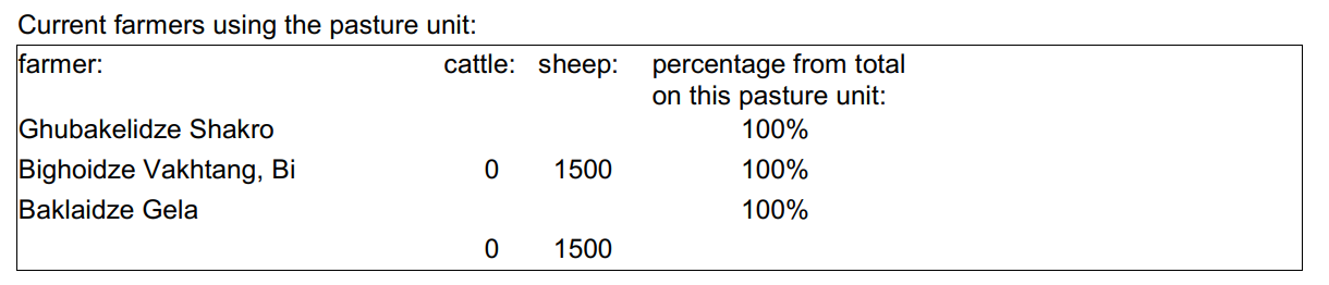
As part of the spatial planning of Akhmeta municipality, pastureland that can be leased to shepherds was separated from land used as hay meadows, farmland or pastures belonging to the villagers. The resulting map shows land available to the village and land available for lease. To understand the current use of pastureland, farms, livestock numbers and pasture units were assessed. In workshops with the local stakeholders and potential users of the results (shepherds, Tusheti Protected Landscape Administration, Tusheti NP Administration, APA), the design of the pasture passports was developed. Each pasture unit is described on four pages in the pasture passport.
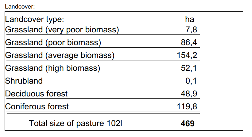
Each pasture unit is described on four pages in the pasture passport: Header: the number (code), total area; content: map of the land cover types, the area of each land cover type, map of available biomass and carrying capacity, name of farmers/shepherds and their livestock numbers using the pasture unit
Spatial Planning Department and Construction Policy (within the Ministry of Regional Development and Infrastructure MRDI), and the Agency of Protected Areas APA (within the Ministry of Environmental Protection and Agriculture MEPA), are key stakeholders to use the pasture passports and to further develop and upscale this approach to other protected areas in Georgia. Beside APA, the Tusheti Protected Landscape Administration (TPLA), located within the Akhmeta municipality administration, is the second important user of pasture passports.
The pasture passports are showing not only the boundaries of each pasture unit, but also those areas that must not be grazed because this lands are part of strict protected areas or areas of high erosion risk. This helps shepherds to guide their flocks to the right places and the park rangers to check, if the regulations are respected correctly.
2.3 Fotos da abordagem
Galeria de Mídias
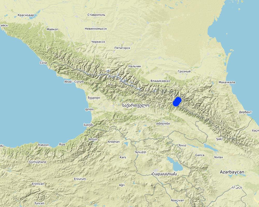
2.5 País/região/locais onde a abordagem foi aplicada
País:
Geórgia
Região/Estado/Província:
Tusheti
Especificação adicional de localização:
Entire territory of Tusheti Protected Areas (1100 km²)
Comentários:
Tusheti is located in the north-eastern of Georgia in the Higher Caucasus bordering Dagestan, Russia. The territory consists of the Tusheti Strict Nature Reserve (12,627 ha), Tusheti National Park (69,515 ha), and Tusheti Protected Landscape (31,517 ha), which includes around 40 villages and settlements.
Full territory of Tusheti Protected Areas (1100 km²)
Map
×2.6 Datas de início e término da abordagem
Indique o ano de início:
2016
2.7 Tipo de abordagem
- Baseado em projeto/programa
2.8 Principais metas/objetivos da abordagem
Support land use planning and decision-making processes for better management of natural resources, especially pastures.
2.9 Condição que propiciam ou inibem a implementação de tecnologia/tecnologias aplicada(s) segundo a abordagem
Normas e valores sociais/culturais/religiosos
- Propício
There is a strong identification of the local communities with the traditional pasture land use and the communities are willing to establish a long-term sustainable land management.
Disponibilidade/acesso a recursos e serviços financeiros
- Inibitivo
Missing financial resources is hindering the implementation of the approach.
Quadro institucional
- Propício
Good cooperation between the relevant institutions on the national and municipal level enabled a successful implementation. The Agency of Protected Areas (APA) located at the Ministry of Environmental Protection and Agriculture (MEPA) and the Tusheti Protected Landscape Administration (TPLA), located within the Akhmeta municipality administration are responsible for contracting lease agreements with shepherds and should not only be able to understand the technology behind the passports but should also have the capacity to handle the technology to be able to adapt the passports if needed (e.g., by changing boundaries of pasture units). For this issue, training workshops with decision-makers and technicians from the MoEPA, APA with TNP Administration and Administration of Akhmeta Munucuaplity with TPLA have been implemented.
Collaboration/ coordination of actors: All relevant national and local authorities that are dealing with spatial or environmental data participated in the workshop to discuss the approach and institutional suitability to host the sensitivity modelSoil Erosion Risk Model.
Colaboração/coordenção de atores
- Propício
All relevant national and local authorities that are dealing with spatial or environmental data participated in the workshop to discuss the approach and institutional suitability to host the Soil Erosion Risk Model.
Conhecimento sobre GST, acesso a suporte técnico
- Inibitivo
There is a high need for technical infrastructure and strong human capacity development.
3. Participação e papel das partes interessadas envolvidas
3.1 Partes interessadas envolvidas na abordagem e seus papéis
- Usuários de terra/comunidades locais
Shephards, local communities
Participation at the workshop/meeting and
making contributions through comments,
suggestions and sharing their analytical point
of view.
- Especialistas em GST/ consultor agrícola
GIS-LAB (Georgian scientific GIS service provider)
National experts on remote sensing and modelling of erosion risk.
- Pesquisadores
National ecologists from universities
- Organização não governamental
Centre for Biodiversity Research & Conservation (NACRES);
staff and experts from FATPA (Friends Association of Tusheti Protected Areas);
local NGO's
Interviews with local stakeholders, field experts
- Governo local
Municipality of Akhmeta and Tusheti Protected Landscape Management
Participation at the workshop where they have given input and made contributions to the topic of technical aspects of the approach.
- Governo nacional (planejadores, responsáveis pelas decisões)
National Park management and APA (Agency for Protected Areas)
Long term aplication and upscaling on national level.
- Organização internacional
Deutsche Gesellschaft fuer Zusammenarbeit (GIZ)
Funding and supervision of the implementation process.
3.2 Envolvimento do usuários de terra/comunidades locais nas diferentes fases da abordagem
| Envolvimento do usuários de terra/comunidades locais | Especifique quem estava envolvido e descreva as atividades | |
|---|---|---|
| Iniciação/motivação | Passivo | |
| Planejamento | Passivo | |
| Implementação | Participativo | Organized meetings, workshop where stakeholders, local communities discussed different technical methodologies, visited the project communities and evaluated the preliminary result maps of erosion risk in the field. |
| Monitoramento/avaliação | Passivo |
3.3 Fluxograma (se disponível)
Descrição:
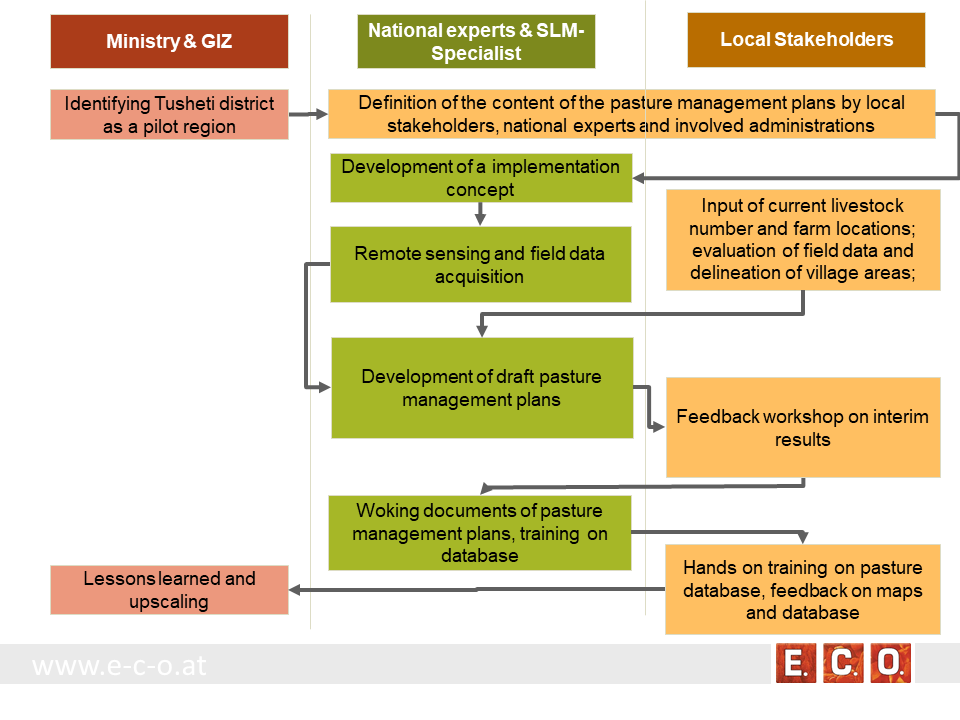
The process of generating pasture passports consists of several phases. The needs and expected content of the pasture management plans was defined in the early stage of the project by the local stakeholders, national experts and involved administrations. The preparation of the pasture management plans was an iterative process between the remotsensing and field sampling results and feedback and input from local stakeholders.
•
Autor:
Hanns Kirchmeir
3.4 Decisão sobre a seleção de tecnologia/tecnologias de GST
Especifique quem decidiu sobre a seleção de tecnologia/tecnologias a serem implementadas:
- Principalmente especialistas em GST, após consulta com usuários da terra
Especifique em que base foram tomadas as decisões:
- Avaliação de conhecimento bem documentado de GST (tomada de decisão baseada em evidências)
4. Suporte técnico, reforço das capacidades e gestão do conhecimento
4.1 Reforço das capacidades/formação
Foi oferecida formação aos usuários da terra/outras partes interessadas?
Sim
Especifique quem foi capacitado:
- Equipe de campo/consultores
Tipo de formação:
- Áreas de demonstração
Tipo de formação:
- workshop with field mission
Assuntos abordados:
Evaluation of model results, preliminary result maps of erosion risk in the field, technical implementation of the sensitivity model in Georgia.
Comentários:
The workshops were combined with field missions to evaluate model results directly in the field. The expert teams went into the project communities and evaluated the preliminary result maps of erosion risk in the field together with local stakeholders.
4.2 Serviço de consultoria
Os usuários de terra têm acesso a um serviço de consultoria?
Sim
Especifique se foi oferecido serviço de consultoria:
- Em centros permanentes
Descreva/comentários:
Located on district level in Telavi
4.3 Fortalecimento da instituição (desenvolvimento organizacional)
As instituições foram fortalecidas ou estabelecidas através da abordagem?
- Sim, moderadamente
Especifique a que nível (níveis) as instituições foram fortalecidas ou estabelecidas:
- Local
- Regional
- Nacional
Descreva instituição, papéis e responsabilidades, membros, etc.
The results of the approach implementation in Georgia has been summarized by the Programme ”Integrated Biodiversity Management, South Caucasus” and distributed to the experts in Azerbaijan for the further implementation.
Approach and results have been handed over to the local municipality responsible for the lease contracts in the Protected Landscape and to APA, which is responsible for the land use in the national park to integrate them into their pasture management plans.
Especifique o tipo de apoio:
- Financeiro
- Reforço das capacidades/formação
- sharing the concept, approach
Dê mais detalhes:
The concept and approach has been shared with local municipalities and other related experts.
Pilot study financed by GIZ.
4.4 Monitoramento e avaliação
Monitoramento e avaliação são partes da abordagem?
Sim
Comentários:
Within the project a basline was drawn with the current livestock numbers, the current available fodder biomass and the current state of erosion.
Caso afirmativo, esta documentação é destinada a ser utilizada para monitoramento e avaliação?
Sim
Comentários:
The remote sensing technology enables a sound methodology to compare the state of erosion and the biomass volume based on satelite data after some years with the baseline values from 2017.
4.5 Pesquisa
A pesquisa foi parte da abordagem?
Sim
Especifique os tópicos:
- Tecnologia
Dê mais detalhes e indique quem realizou a pesquisa:
National and international ecologists did research on vegetation details and biomass as well as on the remote sensing technology.
5. Financiamento e apoio material externo
5.1 Orçamento anual para o componente de GST da abordagem
Caso o orçamento exato seja desconhecido, indique a faixa:
- 10.000-100.000
Comentários (p. ex. principais fontes de recursos/principais doadores):
The funds came from the Integrated Erosion Control project which aas launched as part of the Integrated Biodiversity Management, South Caucasus (IBiS) Programme of the Deutsche Gesellschaft für Internationale Zusammenarbeit (GIZ)
5.2 Apoio financeiro/material concedido aos usuários da terra
Os usuários da terra receberam apoio financeiro/material para a implementação de tecnologia/tecnologias?
Não
5.3 Subsídios para entradas específicas (incluindo mão-de-obra)
- Nenhum
Se a mão-de-obra pelos usuários da terra foi uma entrada substancial, isso foi:
- Voluntário
Comentários:
There was a questionnaire and land-users shared their information on land-use practice.
5.4 Crédito
Foi concedido crédito segundo a abordagem para atividades de GST?
Não
5.5 Outros incentivos ou instrumentos
Foram utilizados outros incentivos ou instrumentos para promover a implementação das tecnologias de GST?
Sim
Caso afirmativo, especifique:
The Agency of Protected Areas (APA) thinks about upscaling the pasture passport method on a national level and establish the approach also in other protected areas of Georgia.
6. Análise de impactos e declarações finais
6.1 Impactos da abordagem
A abordagem concedeu autonomia aos usuários locais de terra, melhorou a participação das partes interessadas?
- Não
- Sim, pouco
- Sim, moderadamente
- Sim, significativamente
Through the field visits and workshops, it has involved both experts and authorities, where they have assessed, analysed and given input.
A abordagem propiciou a tomada de decisão baseada em evidências?
- Não
- Sim, pouco
- Sim, moderadamente
- Sim, significativamente
By the assessment of biomass, the carrying capacity of each pasture unit was calculated.
A abordagem aprimorou o conhecimento e as capacidades dos usuários da terra para implementar a GST?
- Não
- Sim, pouco
- Sim, moderadamente
- Sim, significativamente
The perception of the key stakeholders and management towards the importance of biodiversity and ecosystem services has become more positive.
A abordagem aprimorou o conhecimento e as capacidades de outras partes interessadas?
- Não
- Sim, pouco
- Sim, moderadamente
- Sim, significativamente
The implementation capacity of line ministries, their subordinate bodies and of training institutions regarding the management of biodiversity and ecosystem services is improved at the national level.
A abordagem construiu/fortaleceu instituições, colaboração entre partes interessadas?
- Não
- Sim, pouco
- Sim, moderadamente
- Sim, significativamente
A cooperation between the local Administration of the Protected Landscape (managed by municipality) and the Administration of National Park (managed by national Agency of Protected Areas) was strengthened.
Promoted better coordination of biodiversity and ecosystem services management across sectors based on solid data.
6.2 Principal motivação dos usuários da terra para implementar a GST
- Produção aumentada
- Degradação do solo reduzida
6.3 Atividades de sustentabilidade de abordagem
Os usuários da terra podem manter o que foi implementado através da abordagem (sem apoio externo)?
- Sim
Caso afirmativo, descreva como:
The remote sensing technology is not available to the land users, but the results (pasture passports) can be used by shepherds and local authorities to adjust the grazing intensity to the maximum carrying capacity of each pasture unit.
6.4 Pontos fortes/vantagens da abordagem
| Pontos fortes/vantagens/oportunidades na visão do usuário da terra |
|---|
| The pasture passports are describing each pasture unit available for lease not only by size but also by the amount of available fodder biomass. This is representing the productivity and the maps are showing the accessibility of the fodder biomass to the livestock. This is essential for a more accurate prize estimation on the value of each pasture compared to old data just giving the size of the pasture unit. |
| The pasture passports are improving the legal basis for the lease contract. Areas that should not be grazed (strict protected areas, forests, areas of high erosion risk) are clearly shown on the map. |
| During the preparation process the village related areas and the pastures for lease have been defined and mapped. This leads to clear responsibilities for the different pasture lands. |
| Pontos fortes/vantagens/oportunidades na visão do compilador ou de outra pessoa capacitada |
|---|
| Contribution to the work by local municipalities - the overall results have been handed over to the municipality, responsible for the lease contracts in the Protected Landscape and to APA, responsible for the land use in the National Park. |
| The remote sensing technology is an objective method to assess the state of the pasture land and can be reproduced at any future time or in other areas of the Caucasus. |
| The GIS data and databases can support the administrative process of preparing lease contracts and can additionally be used for further research activities. |
6.5 Pontos fracos, desvantagens da tecnologia e formas de superá-los
| Pontos fracos/desvantagens/riscos na visão do usuário da terra | Como eles podem ser superados? |
|---|---|
| Informal land use practises are now documented and fixed in lease contracts. That might lead to higher costs (lease) and reduce the profit of the shepherd/livestock owner. | It needs to be communicated that long term lease contracts guarantee the shepherds/livestock owner grazing rights for several years. Investments into pasture quality and infrastructure become more meaningful. |
| Pontos fracos/vantagens/riscos na visão do compilador ou de outra pessoa capacitada | Como eles podem ser superados? |
|---|---|
| The preparation process includes high investment of resources in the first setup of the remote sensing data, field evaluation and database development. It needs special experts and know how. | Remote sensing becomes cheaper when applied on large areas. A distribution of field samples across the whole Caucasus range would enable to upscale from the pilot area to a much wider range with less costs per hectare pasture land. |
7. Referências e links
7.1 Métodos/fontes de informação
- visitas de campo, pesquisas de campo
- entrevistas com especialistas em GST
34 experts have participated at the workshop on remote-sensing tools for erosion control and pasture management in Tusheti.
7.2 Referências às publicações disponíveis
Título, autor, ano, ISBN:
Kirchmeir H. 12/2018: Implementation of an Erosion Risk Assessment tool on pilot regions in the Southern Caucasus. The Programme „Integrated Biodiversity Management, South Caucasus”
7.3 Links para informação relevante que está disponível online
Título/ descrição:
The European GeoNode system
URL:
http://pegasosdi.uab.es/geoportal/
Título/ descrição:
Monitoring Manual for Highland Pastures in the Caucasus
URL:
https://biodivers-southcaucasus.org/uploads/files/Monitoring%20Manual%20Draft%20ENG_new%20%20amendments%20for%20Georgia_v9_acc.amend.pdf
Links e módulos
Expandir tudo Recolher tudoLinks
Permanent grass cover in vineyards [Hungria]
Permanent grass cover under grape vines protects the soil surface against erosion and compaction - and provides better conditions for traffic within the rows during mechanised field operations
- Compilador/a: Brigitta Szabó
Remote Sensing as a Tool for Land Degradation … [Geórgia]
Land degradation contributes to biodiversity loss and the impoverishment of rural livelihoods in Tusheti. Above all, however, land degradation are triggered by climate change as traditional land use practise might not be adapted to new climate conditions which can cause or speed up degradation processes significantly. On the other hand, …
- Compilador/a: Hanns Kirchmeir
Módulos
Não há módulos