Integrated Pasture Management Planning in Mountainous Regions [Грузия]
- Создание:
- Обновить:
- Составитель: Hanns Kirchmeir
- Редакторы: Natia Kobakhidze, Christian Goenner, Jonathan Etzold
- Рецензент: Rima Mekdaschi Studer
approaches_5490 - Грузия
Просмотреть разделы
Развернуть все Свернуть все1. Общая информация
1.2 Контактные данные специалистов и организаций, участвующих в описании и оценке Подхода
Специалист по УЗП:
co-compiler:
Специалист по УЗП:
Название проекта, содействовавшего документированию/оценке Подхода (если применимо)
Integrated Biodiversity Management, South Caucasus (IBiS)Название организации (-ий), содействовавших документированию/оценке Подхода (если применимо)
Deutsche Gesellschaft für Internationale Zusammenarbeit (GIZ)1.3 Условия, регламентирующие использование собранных ВОКАТ данных
Когда были собраны данные (на местах)?
01/02/2016
Составитель и ответственный/-ые специалист(-ы) согласны с условиями, регламентирующими использование собранных ВОКАТ данных:
Да
1.4 Ссылка (-и) на Анкету (-ы) по Технологиям УЗП
Permanent grass cover in vineyards [Венгрия]
Permanent grass cover under grape vines protects the soil surface against erosion and compaction - and provides better conditions for traffic within the rows during mechanised field operations
- Составитель: Brigitta Szabó
Remote Sensing as a Tool for Land Degradation … [Грузия]
Land degradation contributes to biodiversity loss and the impoverishment of rural livelihoods in Tusheti. Above all, however, land degradation are triggered by climate change as traditional land use practise might not be adapted to new climate conditions which can cause or speed up degradation processes significantly. On the other hand, …
- Составитель: Hanns Kirchmeir
2. Описание Подхода УЗП
2.1 Краткое описание Подхода
The unsustainable use of pastures and forest areas has led to soil erosion, degradation, desertification and loss of biodiversity in the high mountain areas of the South Caucasus. The development of pasture passports is part of a broader approach to a strategic pasture management plan for Tusheti. This showcase includes results from the spatial planning process applied in a pilot programme for Akhmeta municipality.
2.2 Подробное описание Подхода
Подробное описание Подхода:
Project area and purpose
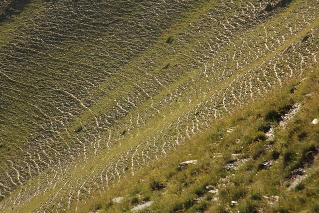
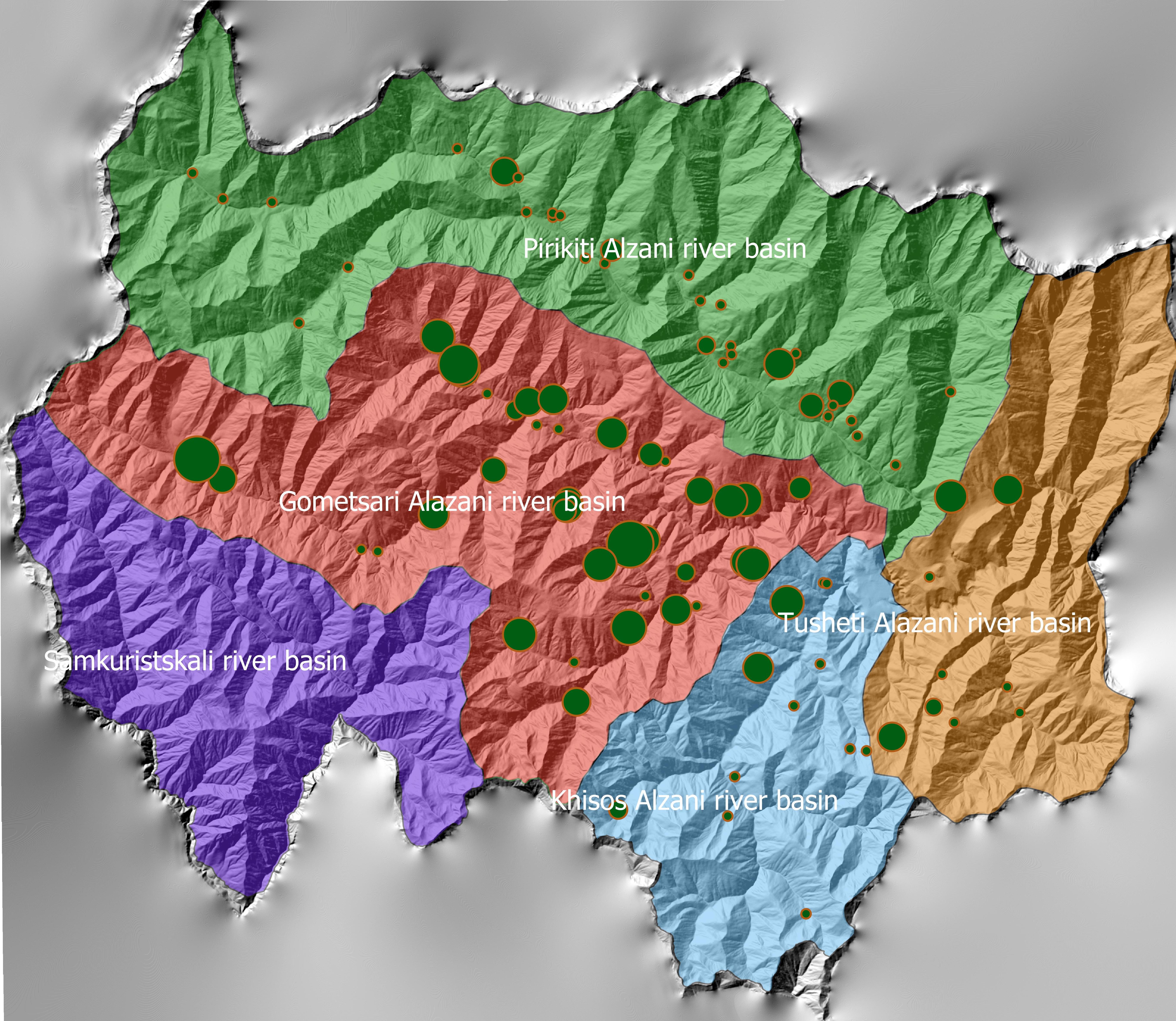
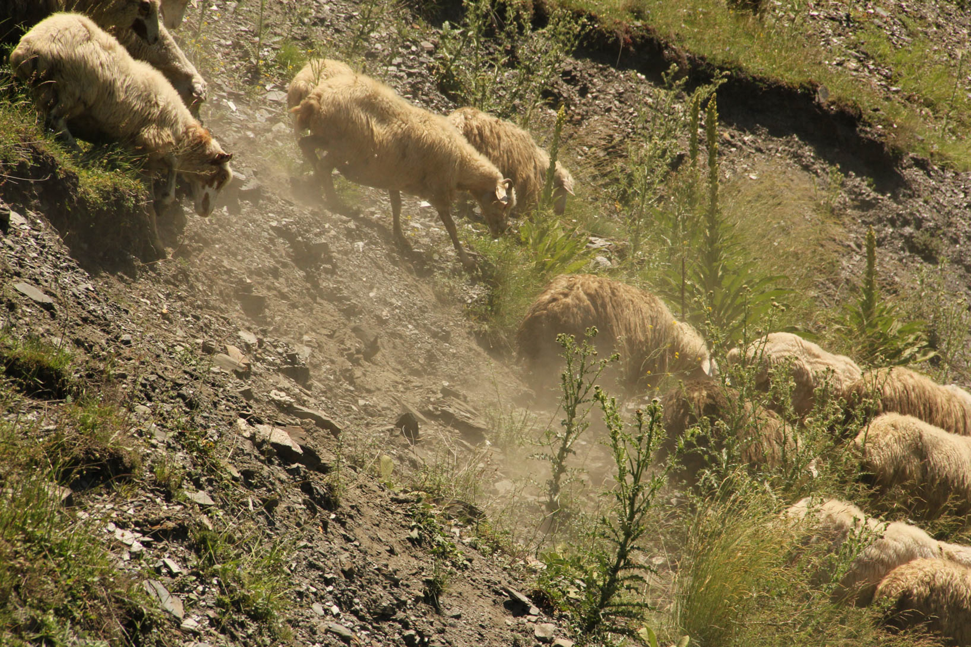
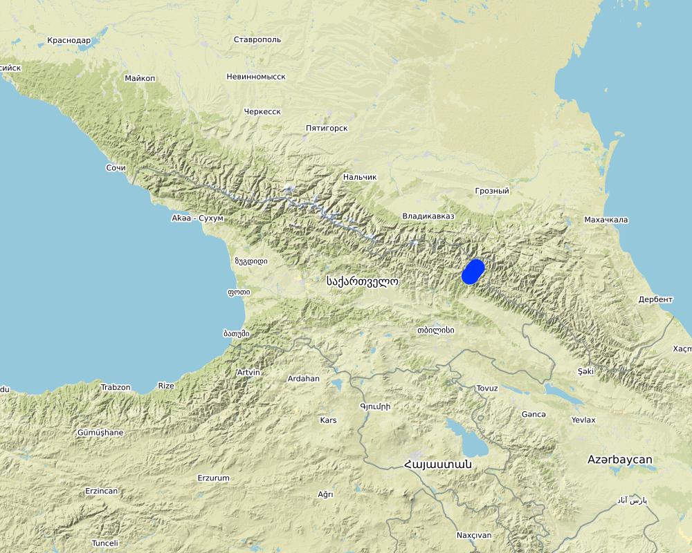
The project area comprises the Tusheti Protected Areas (PAs) on the northern slopes of the Greater Caucasus Mountains in Georgia. This group of protected areas consists of a strict nature reserve, a national park and a protected landscape with about 40 villages and settlements. Together they form a total protected area of approx. 114,000 ha. In Tusheti, overgrazing has led, especially in the eastern part with a higher number of villages and roads, to soil erosion and biodiversity loss. Especially the intensive use of summer pastures during the Soviet period resulted in a severe deterioration of the mountain slopes. So far, there are no standards or guidelines for the elaboration of sustainable pasture management plans in Georgia. Pasture passports, as a first step towards sustainable pasture management, document the actual grazing capacity for each pasture unit and serve as a guiding document for shepherds and local stakeholders and as a basis to prepare lease contracts.
Data gathering
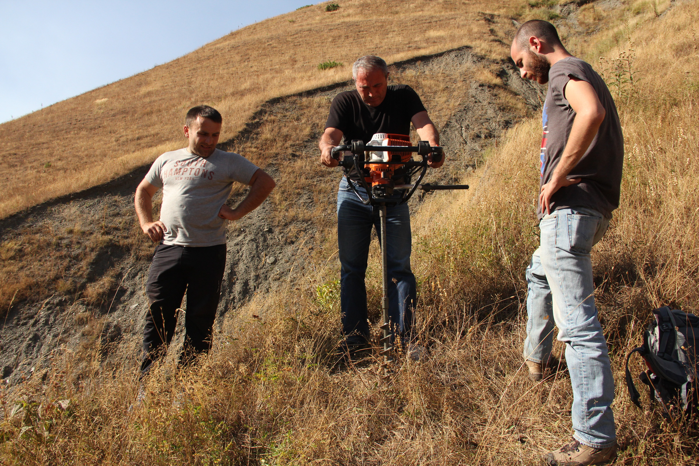
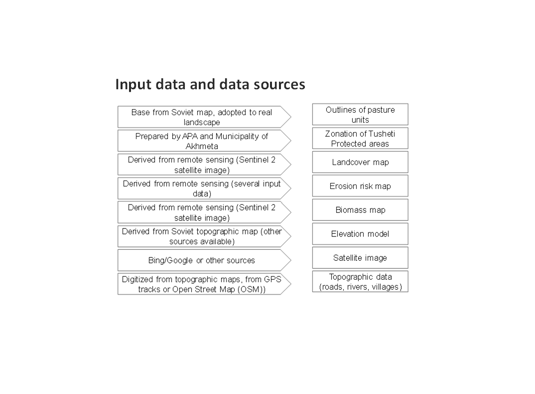
As a prerequisite for the development of pasture passports and the calculation of grazing capacity, the type of land cover, the erosion risk and the biomass of the pastureland had to be assessed for each pasture unit. This was done using remote sensing tools in combination with data collected in the field for calibration.
The details on the methodology of the Land Cover & Biomass as well as the Erosion Risk Assessment can be found in the WOCAT technology on "Remote Sensing as a Tool for Land Degradation Neutrality Monitoring" (see link).
Evaluation and Ground Truthing
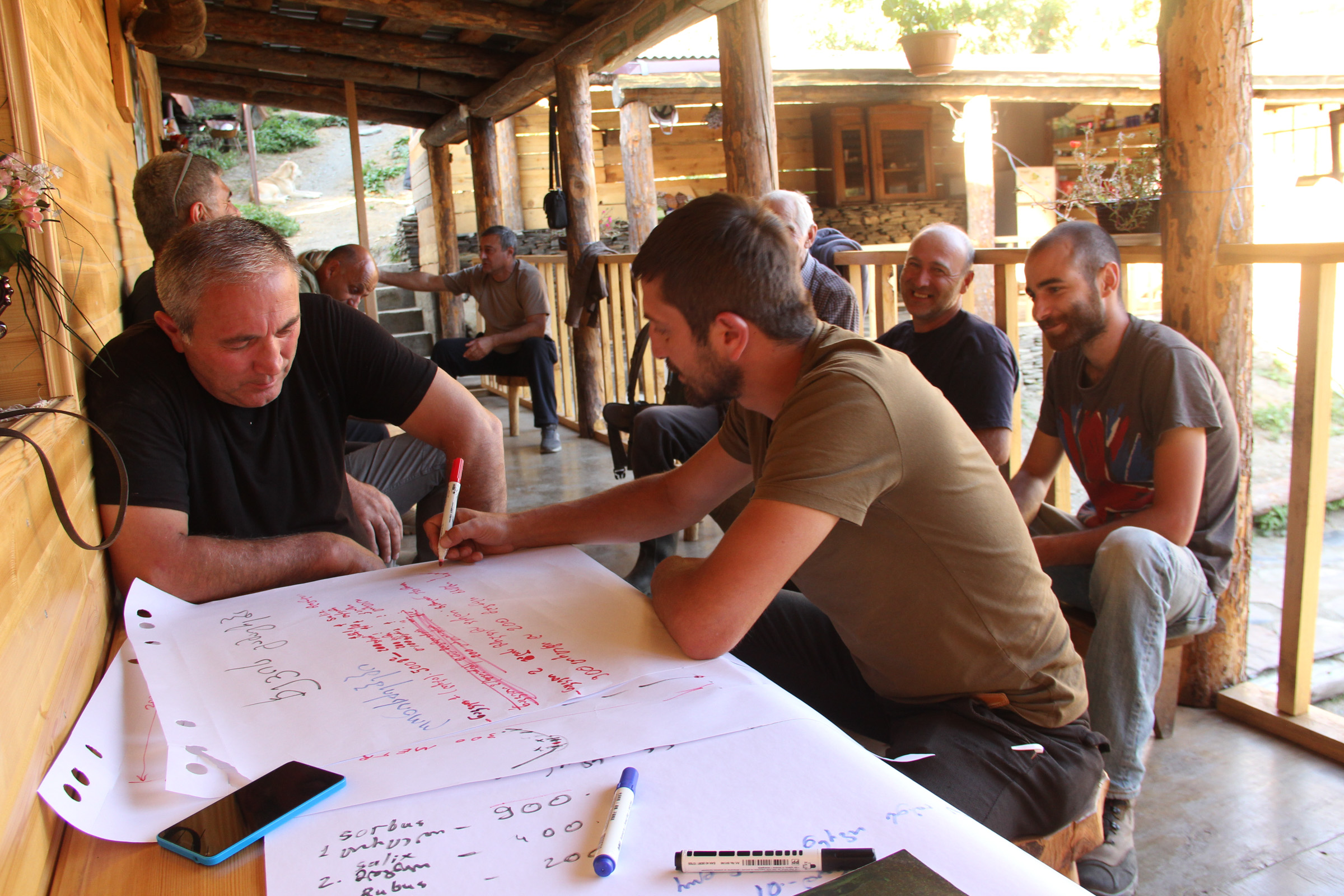
All interim results have been checked and evaluated by local stakeholders, national experts and experts from local administrations. It was important not only to conduct workshops in seminar rooms but to meet the local stakeholders in the field and to discuss the problems and challenges of pasture management on place in the field. At this workshops all levels of decision makers were included (Ministries, Donor organisations, international and national experts, local administrations and land users). This was important to create a common understanding of the current situation from different perspectives (nature conservation, administration, shepherds ...). The combination of remote sensing with calibration data from the field can be summarised as a very effective method to assess the erosion state in large areas. Neither of the two instruments would be able to provide results in this spatial dimension and quality alone.
Pasture Passports
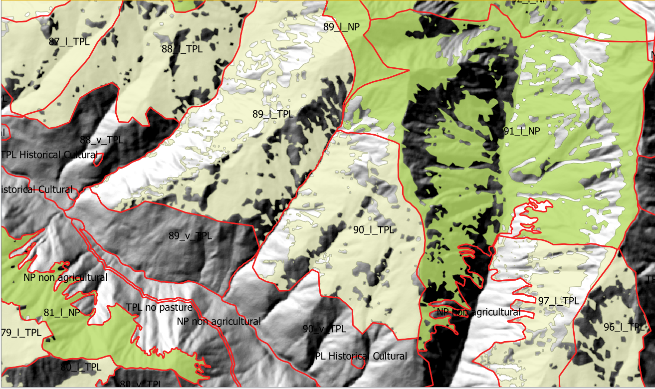
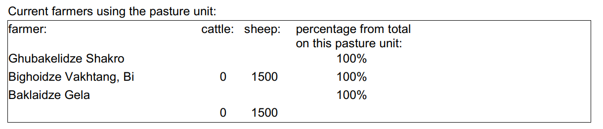
As part of the spatial planning of Akhmeta municipality, pastureland that can be leased to shepherds was separated from land used as hay meadows, farmland or pastures belonging to the villagers. The resulting map shows land available to the village and land available for lease. To understand the current use of pastureland, farms, livestock numbers and pasture units were assessed. In workshops with the local stakeholders and potential users of the results (shepherds, Tusheti Protected Landscape Administration, Tusheti NP Administration, APA), the design of the pasture passports was developed. Each pasture unit is described on four pages in the pasture passport.
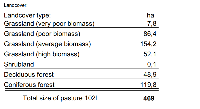
Each pasture unit is described on four pages in the pasture passport: Header: the number (code), total area; content: map of the land cover types, the area of each land cover type, map of available biomass and carrying capacity, name of farmers/shepherds and their livestock numbers using the pasture unit
Spatial Planning Department and Construction Policy (within the Ministry of Regional Development and Infrastructure MRDI), and the Agency of Protected Areas APA (within the Ministry of Environmental Protection and Agriculture MEPA), are key stakeholders to use the pasture passports and to further develop and upscale this approach to other protected areas in Georgia. Beside APA, the Tusheti Protected Landscape Administration (TPLA), located within the Akhmeta municipality administration, is the second important user of pasture passports.
The pasture passports are showing not only the boundaries of each pasture unit, but also those areas that must not be grazed because this lands are part of strict protected areas or areas of high erosion risk. This helps shepherds to guide their flocks to the right places and the park rangers to check, if the regulations are respected correctly.
2.3 Фотографии, иллюстрирующие Подход
Медиа-галерея
2.5 Страна/ регион/ место, где применялся Подход
Страна:
Грузия
Административная единица (Район/Область):
Tusheti
Более точная привязка места:
Entire territory of Tusheti Protected Areas (1100 km²)
Комментарии:
Tusheti is located in the north-eastern of Georgia in the Higher Caucasus bordering Dagestan, Russia. The territory consists of the Tusheti Strict Nature Reserve (12,627 ha), Tusheti National Park (69,515 ha), and Tusheti Protected Landscape (31,517 ha), which includes around 40 villages and settlements.
Full territory of Tusheti Protected Areas (1100 km²)
Map
×2.6 Даты начала и окончания реализации Подхода
Год начала реализации:
2016
2.7 Тип Подхода
- в рамках проекта/ программы
2.8 Каковы цели/ задачи Подхода
Support land use planning and decision-making processes for better management of natural resources, especially pastures.
2.9 Условия содействующие применению Технологии/ Технологий в рамках Подхода или затрудняющие его
Социальные/ культурные/ религиозные нормы и ценности
- содействуют
There is a strong identification of the local communities with the traditional pasture land use and the communities are willing to establish a long-term sustainable land management.
Наличие/ доступность финансовых ресурсов и услуг
- затрудняют
Missing financial resources is hindering the implementation of the approach.
Институциональные условия
- содействуют
Good cooperation between the relevant institutions on the national and municipal level enabled a successful implementation. The Agency of Protected Areas (APA) located at the Ministry of Environmental Protection and Agriculture (MEPA) and the Tusheti Protected Landscape Administration (TPLA), located within the Akhmeta municipality administration are responsible for contracting lease agreements with shepherds and should not only be able to understand the technology behind the passports but should also have the capacity to handle the technology to be able to adapt the passports if needed (e.g., by changing boundaries of pasture units). For this issue, training workshops with decision-makers and technicians from the MoEPA, APA with TNP Administration and Administration of Akhmeta Munucuaplity with TPLA have been implemented.
Collaboration/ coordination of actors: All relevant national and local authorities that are dealing with spatial or environmental data participated in the workshop to discuss the approach and institutional suitability to host the sensitivity modelSoil Erosion Risk Model.
Сотрудничество/ координация действий
- содействуют
All relevant national and local authorities that are dealing with spatial or environmental data participated in the workshop to discuss the approach and institutional suitability to host the Soil Erosion Risk Model.
Осведомленность в области УЗП, доступность технической поддержки
- затрудняют
There is a high need for technical infrastructure and strong human capacity development.
3. Участие и распределение ролей заинтересованных сторон
3.1 Заинтересованные стороны, участвующие в реализации Подхода и их роли
- местные землепользователи/ местные сообщества
Shephards, local communities
Participation at the workshop/meeting and
making contributions through comments,
suggestions and sharing their analytical point
of view.
- эксперты по УЗП/ сельскому хозяйству
GIS-LAB (Georgian scientific GIS service provider)
National experts on remote sensing and modelling of erosion risk.
- ученые-исследователи
National ecologists from universities
- общественные организации
Centre for Biodiversity Research & Conservation (NACRES);
staff and experts from FATPA (Friends Association of Tusheti Protected Areas);
local NGO's
Interviews with local stakeholders, field experts
- местные власти
Municipality of Akhmeta and Tusheti Protected Landscape Management
Participation at the workshop where they have given input and made contributions to the topic of technical aspects of the approach.
- государственные власти (отвечающие за планирование или принятие решений)
National Park management and APA (Agency for Protected Areas)
Long term aplication and upscaling on national level.
- международные организации
Deutsche Gesellschaft fuer Zusammenarbeit (GIZ)
Funding and supervision of the implementation process.
3.2 Участие местных землепользователей/ местных сообществ на разных стадиях реализации Подхода
| Участие местных землепользователей/ местных сообществ | Перечислите участников и опишите их вовлеченность | |
|---|---|---|
| инициирование/ мотивация | пассивное | |
| планирование | пассивное | |
| выполнение | интерактивное | Organized meetings, workshop where stakeholders, local communities discussed different technical methodologies, visited the project communities and evaluated the preliminary result maps of erosion risk in the field. |
| мониторинг/ оценка | пассивное |
3.3 Схема реализации (если имеется)
Описание:
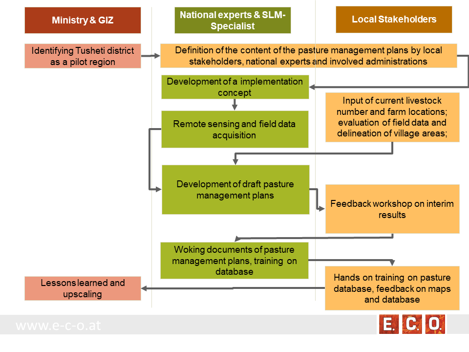
The process of generating pasture passports consists of several phases. The needs and expected content of the pasture management plans was defined in the early stage of the project by the local stakeholders, national experts and involved administrations. The preparation of the pasture management plans was an iterative process between the remotsensing and field sampling results and feedback and input from local stakeholders.
•
Автор:
Hanns Kirchmeir
3.4 Принятие решений по выбору Технологии/ Технологий УЗП
Укажите, кто принимал решение по выбору применяемой Технологии/ Технологий:
- преимущественно специалисты по УЗП после консультаций с землепользователями
Поясните на чём было основано принятие решений:
- анализ подробно описанного опыта и знаний по УЗП (принятие решений на основе подтвержденных фактов)
4. Техническая поддержка, повышение компетенций и управление знаниями
4.1 Повышение компетенций/ обучение
Проводилось ли обучение землепользователей/ других заинтересованных лиц?
Да
Укажите, кто проходил обучение:
- местный персонал/консультанты
Тип обучения:
- опытные участки
Тип обучения:
- workshop with field mission
Рассматриваемые темы:
Evaluation of model results, preliminary result maps of erosion risk in the field, technical implementation of the sensitivity model in Georgia.
Комментарии:
The workshops were combined with field missions to evaluate model results directly in the field. The expert teams went into the project communities and evaluated the preliminary result maps of erosion risk in the field together with local stakeholders.
4.2 Консультационные услуги
Есть ли у землепользователей возможность получать консультации?
Да
Укажите, где именно оказываются консультационные услуги:
- в постоянно функционирующих центрах
Описание/ комментарий:
Located on district level in Telavi
4.3 Институциональная (организационная) поддержка
В ходе реализации Подхода были ли организованы новые институциональные структуры или поддержаны уже существующие?
- да, умеренно
Укажите уровень, на котором структуры были укреплены или вновь созданы:
- местные
- региональный
- национальный
Опишите организацию, функции и ответственность, членство и т.д.
The results of the approach implementation in Georgia has been summarized by the Programme ”Integrated Biodiversity Management, South Caucasus” and distributed to the experts in Azerbaijan for the further implementation.
Approach and results have been handed over to the local municipality responsible for the lease contracts in the Protected Landscape and to APA, which is responsible for the land use in the national park to integrate them into their pasture management plans.
Укажите тип поддержки:
- финансовая
- повышение компетенций/ обучение
- sharing the concept, approach
Подробнее:
The concept and approach has been shared with local municipalities and other related experts.
Pilot study financed by GIZ.
4.4 Мониторинг и оценка
Являются ли мониторинг и оценка частью Подхода?
Да
Комментарии:
Within the project a basline was drawn with the current livestock numbers, the current available fodder biomass and the current state of erosion.
Если да, будет ли данный документ использоваться для мониторинга и оценки?
Да
Комментарии:
The remote sensing technology enables a sound methodology to compare the state of erosion and the biomass volume based on satelite data after some years with the baseline values from 2017.
4.5 Научные исследования
Были ли научные исследования частью Подхода?
Да
Укажите темы исследований:
- технология
Напишите подробнее и назовите тех, кто выполнял исследования:
National and international ecologists did research on vegetation details and biomass as well as on the remote sensing technology.
5. Финансирование и внешняя материальная поддержка
5.1 Годовой бюджет мероприятий по УЗП в рамках Подхода
Если точный годовой бюжет неизвестен, укажите примерный диапазон затрат:
- 10000-100000
Комментарий (например, основные источники финансирования/ ключевые доноры):
The funds came from the Integrated Erosion Control project which aas launched as part of the Integrated Biodiversity Management, South Caucasus (IBiS) Programme of the Deutsche Gesellschaft für Internationale Zusammenarbeit (GIZ)
5.2 Финансирование и внешняя материальная поддержка, предоставляемая землепользователям
Предоставлялась ли землепользователям финансовая/ материальная поддержка для применения Технологии /Технологий?
Нет
5.3 Субсидии на отдельные затраты (включая оплату труда)
- нет
Если труд землепользователя был существенным вкладом, укажите, был ли этот вклад:
- добровольный
Комментарии:
There was a questionnaire and land-users shared their information on land-use practice.
5.4 Кредитование
Предоставлялись ли в рамках Подхода кредиты на мероприятия УЗП?
Нет
5.5 Другие методы или инструменты стимулирования
Использовались ли другие методы или инструменты стимулирования для продвижения Технологий УЗП?
Да
Если да, поясните:
The Agency of Protected Areas (APA) thinks about upscaling the pasture passport method on a national level and establish the approach also in other protected areas of Georgia.
6. Анализ влияния и заключительные положения
6.1 Влияние Подхода
Сумел ли Подход расширить возможности местных землепользователей, повысить участие заинтересованных сторон?
- Нет
- Да, немного
- Да, умеренно
- Да, существенно
Through the field visits and workshops, it has involved both experts and authorities, where they have assessed, analysed and given input.
Сумел ли Подход дать возможность принимать решения на основе подтвержденных фактов?
- Нет
- Да, немного
- Да, умеренно
- Да, существенно
By the assessment of biomass, the carrying capacity of each pasture unit was calculated.
Сумел ли Подход расширить знания и возможности землепользователей в применении практик УЗП?
- Нет
- Да, немного
- Да, умеренно
- Да, существенно
The perception of the key stakeholders and management towards the importance of biodiversity and ecosystem services has become more positive.
Сумел ли Подход расширить знания и возможности других заинтересованных сторон?
- Нет
- Да, немного
- Да, умеренно
- Да, существенно
The implementation capacity of line ministries, their subordinate bodies and of training institutions regarding the management of biodiversity and ecosystem services is improved at the national level.
Сумел ли Подход укрепить сотрудничество между заинтересоваными сторонами/ выстроить механизмы сотрудничества?
- Нет
- Да, немного
- Да, умеренно
- Да, существенно
A cooperation between the local Administration of the Protected Landscape (managed by municipality) and the Administration of National Park (managed by national Agency of Protected Areas) was strengthened.
Promoted better coordination of biodiversity and ecosystem services management across sectors based on solid data.
6.2 Основные причины, побуждающие землепользователей внедрять УЗП
- рост продуктивности
- снижение деградации земель
6.3 Долгосрочная устойчивость мероприятий в рамках Подхода
Могут ли землепользователи самостоятельно (без внешней поддержки) продолжать применение того, что было реализовано в рамках Подхода?
- да
Если да, опишите как:
The remote sensing technology is not available to the land users, but the results (pasture passports) can be used by shepherds and local authorities to adjust the grazing intensity to the maximum carrying capacity of each pasture unit.
6.4 Сильные стороны/ преимущества Подхода
| Сильные стороны/ преимущества/ возможности по мнению землепользователей |
|---|
| The pasture passports are describing each pasture unit available for lease not only by size but also by the amount of available fodder biomass. This is representing the productivity and the maps are showing the accessibility of the fodder biomass to the livestock. This is essential for a more accurate prize estimation on the value of each pasture compared to old data just giving the size of the pasture unit. |
| The pasture passports are improving the legal basis for the lease contract. Areas that should not be grazed (strict protected areas, forests, areas of high erosion risk) are clearly shown on the map. |
| During the preparation process the village related areas and the pastures for lease have been defined and mapped. This leads to clear responsibilities for the different pasture lands. |
| Сильные стороны/ преимущества/ возможности по мнению составителя или других ключевых специалистов |
|---|
| Contribution to the work by local municipalities - the overall results have been handed over to the municipality, responsible for the lease contracts in the Protected Landscape and to APA, responsible for the land use in the National Park. |
| The remote sensing technology is an objective method to assess the state of the pasture land and can be reproduced at any future time or in other areas of the Caucasus. |
| The GIS data and databases can support the administrative process of preparing lease contracts and can additionally be used for further research activities. |
6.5 Слабые стороны/ недостатки Подхода и пути их преодоления
| Слабые стороны/ недостатки/ риски по мнению землепользователей | Возможные пути их преодоления/снижения? |
|---|---|
| Informal land use practises are now documented and fixed in lease contracts. That might lead to higher costs (lease) and reduce the profit of the shepherd/livestock owner. | It needs to be communicated that long term lease contracts guarantee the shepherds/livestock owner grazing rights for several years. Investments into pasture quality and infrastructure become more meaningful. |
| Слабые стороны/ недостатки/ риски по мнению составителя или ответственных специалистов | Возможные пути их преодоления/снижения? |
|---|---|
| The preparation process includes high investment of resources in the first setup of the remote sensing data, field evaluation and database development. It needs special experts and know how. | Remote sensing becomes cheaper when applied on large areas. A distribution of field samples across the whole Caucasus range would enable to upscale from the pilot area to a much wider range with less costs per hectare pasture land. |
7. Справочные материалы и ссылки
7.1 Методы сбора/источники информации
- выезды на места, полевые обследования
- опросы специалистов/экспертов по УЗП
34 experts have participated at the workshop on remote-sensing tools for erosion control and pasture management in Tusheti.
7.2 Ссылки на опубликованные материалы
Название, автор, год публикации, ISBN:
Kirchmeir H. 12/2018: Implementation of an Erosion Risk Assessment tool on pilot regions in the Southern Caucasus. The Programme „Integrated Biodiversity Management, South Caucasus”
7.3 Ссылки на материалы, доступные онлайн
Название/ описание:
The European GeoNode system
Адрес в сети Интернет:
http://pegasosdi.uab.es/geoportal/
Название/ описание:
Monitoring Manual for Highland Pastures in the Caucasus
Адрес в сети Интернет:
https://biodivers-southcaucasus.org/uploads/files/Monitoring%20Manual%20Draft%20ENG_new%20%20amendments%20for%20Georgia_v9_acc.amend.pdf
Ссылки и модули
Развернуть все Свернуть всеСсылки
Permanent grass cover in vineyards [Венгрия]
Permanent grass cover under grape vines protects the soil surface against erosion and compaction - and provides better conditions for traffic within the rows during mechanised field operations
- Составитель: Brigitta Szabó
Remote Sensing as a Tool for Land Degradation … [Грузия]
Land degradation contributes to biodiversity loss and the impoverishment of rural livelihoods in Tusheti. Above all, however, land degradation are triggered by climate change as traditional land use practise might not be adapted to new climate conditions which can cause or speed up degradation processes significantly. On the other hand, …
- Составитель: Hanns Kirchmeir
Модули
Нет модулей