Silt fences to trap sediment in areas affected by gully erosion [África do Sul]
- Criação:
- Atualização:
- Compilador/a: Dirk Pretorius
- Editor: –
- Revisores: William Critchley, Rima Mekdaschi Studer
Silt fences
technologies_6174 - África do Sul
Veja as seções
Expandir tudo Recolher tudo1. Informação geral
1.2 Detalhes do contato das pessoas capacitadas e instituições envolvidas na avaliação e documentação da tecnologia
Pessoa(s) capacitada(s)
Especialista em GST:
Van Heerden Heinrich
Eco Rhythm Management
África do Sul
Nome do projeto que facilitou a documentação/avaliação da Tecnologia (se relevante)
Working for Water (Natural Resource Management Programmes – DEA, South Africa)?1.3 Condições em relação ao uso da informação documentada através de WOCAT
O compilador e a(s) pessoa(s) capacitada(s) aceitam as condições relativas ao uso de dados documentados através do WOCAT:
Sim
1.4 Declaração de sustentabilidade da tecnologia descrita
A tecnologia descrita aqui é problemática em relação a degradação da terra de forma que não pode ser declarada uma tecnologia de gestão sustentável de terra?
Não
1.5 Referência ao(s) questionário(s) sobre abordagens GST (documentado(s) usando WOCAT)
Working for Water [África do Sul]
Government funded restoration/rehabilitation initiative as part of Working for Water project. Aim was to eradicate alien invasive.
- Compilador/a: Klaus Kellner
2. Descrição da tecnologia de GST
2.1 Descrição curta da tecnologia
Definição da tecnologia:
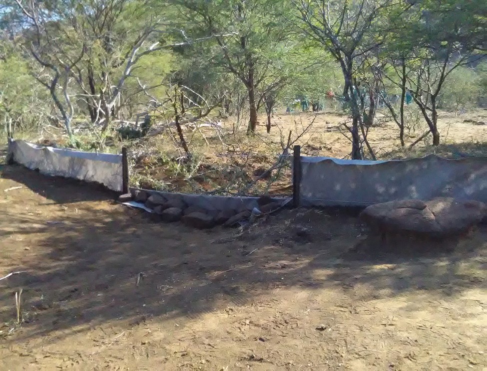
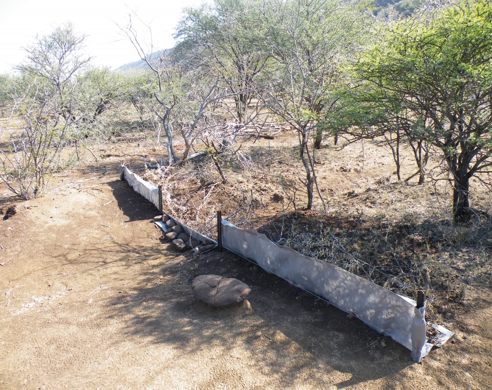
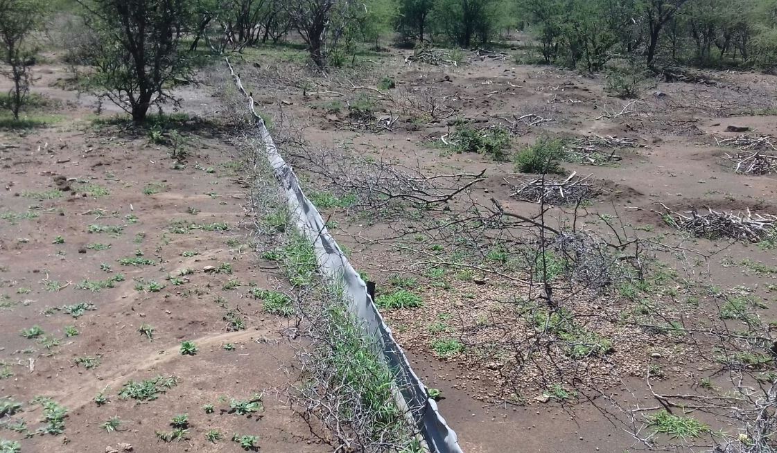
Silt fences together with brush packing were introduced to reduce sediment transport and restoration of gully erosion in the Potlake nature reserve, Limpopo Province, South Africa.
2.2 Descrição detalhada da tecnologia
Descrição:
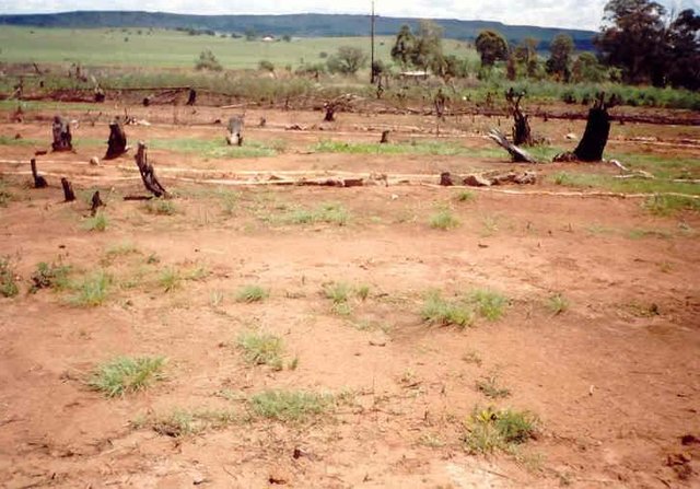
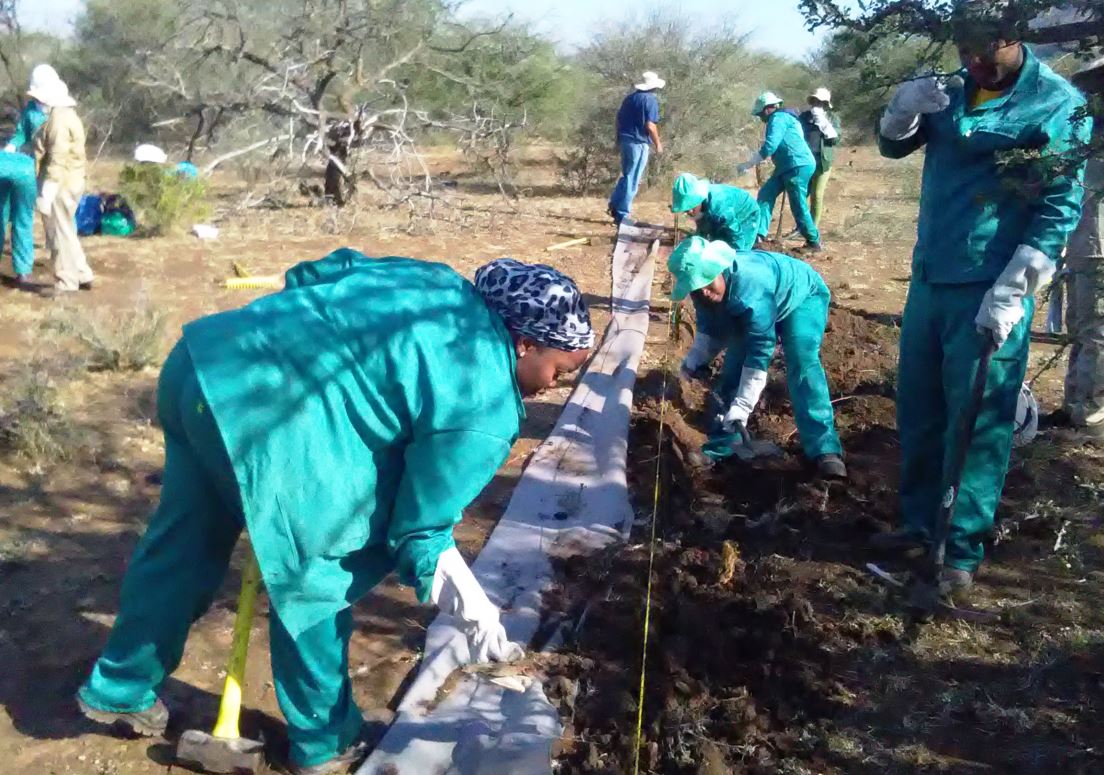
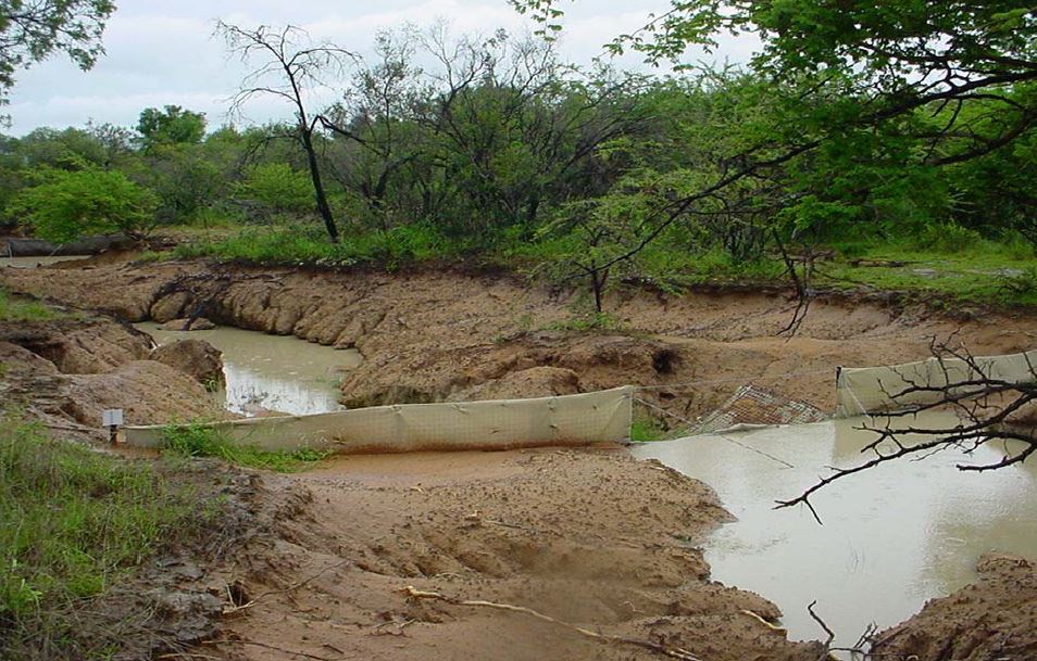
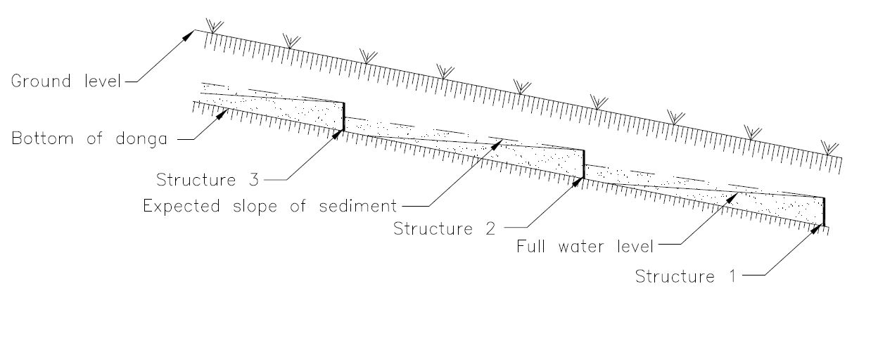
Silt fences, together with brush packing were introduced in the Potlake Game Reserve (2817 ha) in the Limpopo Province of South Africa to rehabilitate areas affected by serious rill and gully erosion. Due to overgrazing on highly erodible soils, gully headcuts are actively migrating upstream. Implementation of the technology leads to enhanced vegetation cover and reduced sediment transport in the gullies. Silt fences are temporary structures and are therefore placed closer together than permanent structures. The placing is such that the silt from the downstream structure builds up against the upstream structure to delay the perishing of the restoration materials. Vegetation must be established in the gully (donga) as soon as possible so that, when the materials decay after about ten years, the area will be restored. Altitudes vary from 1 174 m to 780 m above sea level. The reserve is located in a summer rainfall region and receives an average annual rainfall of 438 mm per year. Clayey duplex soils are prone to both natural and man-induced erosion. The vegetation comprises Central Bushveld vegetation units of the Savanna Biome. Savanna is characterized by a herbaceous layer (usually dominated by grasses) with a woody component. In Southern Africa, Bushveld is an apt description of the vegetation structure, as the vegetation most often does not comprise distinct shrub and tree layers. Instead, the shrubs and trees occur in a matrix with a grass-dominated herb layer. A number of large gullies exist along drainage lines on highly erodible soils. Some of the gullies are up to 1.5 m deep and 5 m wide. A total of around 200 m of silt fences were erected at selected sites in the reserve to retain sediment and to establish vegetation. The following steps were followed in the establishment of the silt fences:
1. Identification of priority sites to erect the silt fences - using Google Earth imagery and field surveys.
2. Acquisition of restoration material and training of local community members on the implementation of the technology (training by Mr. Buckle at that stage from the Department).
3. Levelling of the area where fences would be erected.
4. Construction of fences.
5. Brush packing (upstream of fence) stone packing (downstream in the gully).
2.3 Fotos da tecnologia
Galeria de Mídias
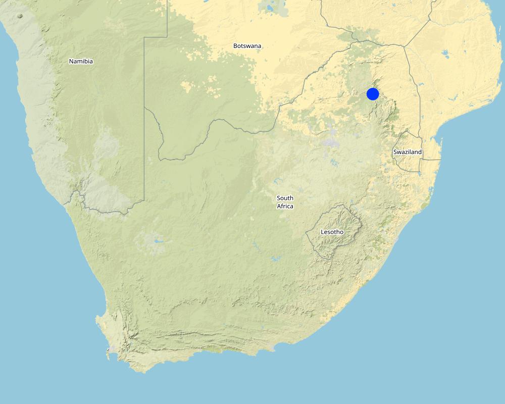
2.5 País/região/locais onde a tecnologia foi aplicada e que estão cobertos nesta avaliação
País:
África do Sul
Região/Estado/Província:
Limpopo Province
Especificação adicional de localização:
Potlake nature reserve
Especifique a difusão da tecnologia:
- Uniformemente difundida numa área
Se a área precisa não for conhecida, indicar a área aproximada coberta:
- 1-10 km2
O(s) local(is) tecnológico(s) está(ão) localizado(s) em uma área permanentemente protegida?
Sim
Caso afirmativo, especifique:
Located in the Potlake nature reserve
Map
×2.6 Data da implementação
Caso o ano exato seja desconhecido, indique a data aproximada:
- menos de 10 anos atrás (recentemente)
2.7 Introdução da tecnologia
Especifique como a tecnologia foi introduzida:
- através de projetos/intervenções externas
3. Classificação da tecnologia de GST
3.1 Principal/principais finalidade(s) da tecnologia
- Reduz, previne, recupera a degradação do solo
- Preserva ecossistema
- Protege uma bacia/zonas a jusante – em combinação com outra tecnologia
3.2 Tipo(s) atualizado(s) de uso da terra onde a tecnologia foi aplicada
Uso do solo misturado dentro da mesma unidade de terra:
Não

Outros
Especifique:
Protected area
Observações:
Potlake nature reserve
3.3 O uso do solo mudou devido à implementação da Tecnologia?
O uso do solo mudou devido à implementação da Tecnologia?
- Não (Continuar com a pergunta 3.4)
Uso do solo misturado dentro da mesma unidade de terra:
Não
3.4 Abastecimento de água
Abastecimento de água para a terra na qual a tecnologia é aplicada:
- Precipitação natural
3.5 Grupo de GST ao qual pertence a tecnologia
- Solo/cobertura vegetal melhorada
- Medidas de curva de nível
3.6 Medidas de GST contendo a tecnologia

Medidas estruturais
- S6: Muros, barreiras, paliçadas, cercas
3.7 Principais tipos de degradação da terra abordados pela tecnologia

Erosão do solo pela água
- Wt: Perda do solo superficial/erosão de superfície
- Wg: Erosão por ravinas/ravinamento
3.8 Redução, prevenção ou recuperação da degradação do solo
Especifique o objetivo da tecnologia em relação a degradação da terra:
- Reduzir a degradação do solo
- Recuperar/reabilitar solo severamente degradado
4. Especificações técnicas, implementação de atividades, entradas e custos
4.1 Desenho técnico da tecnologia
Especificações técnicas (relacionada ao desenho técnico):
Silt fences are cheap and easy to erect, but the overflow depth must be limited. Silt fences are therefore erected in the wider section of a gully.
Autor:
Jan van Heerden
Data:
01/01/2012
Especificações técnicas (relacionada ao desenho técnico):
Silt fences are temporary structures and are therefore placed closer together than permanent structures. The placing is such that the silt from the downstream structure builds up against the upstream structure to delay the perishing of the restoration materials. Vegetation must be established in the gully (donga) as soon as possible so that, when the materials decay after about ten years, the area will be restored.
Autor:
Jan van Heerden
Data:
01/01/2012
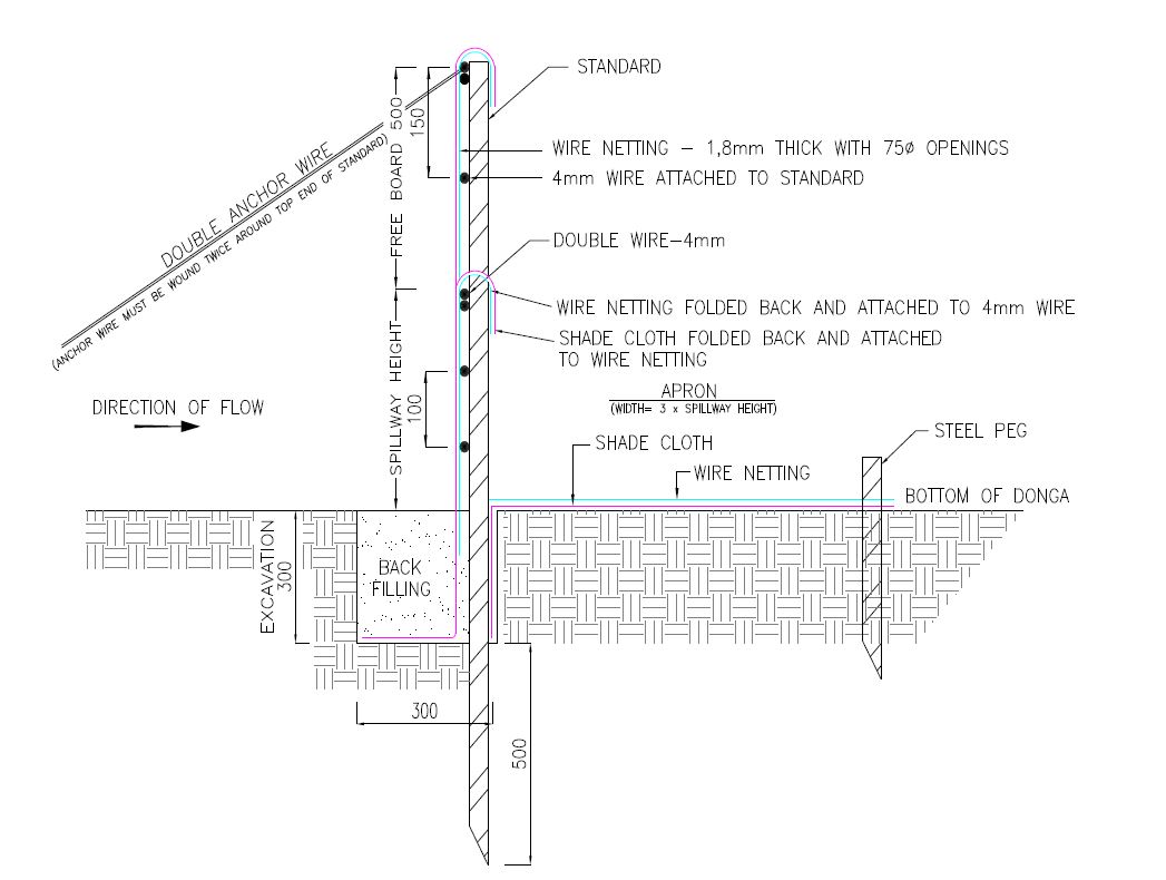
Especificações técnicas (relacionada ao desenho técnico):
1. Dig a pit trench 300 mm × 300 mm from peg to peg over the entire width of the gully.
2. Drive iron standards (iron pole) in on the sides of the spillway length followed by more standards around 1.5 meters apart - ensure equal spacing between standards (standards must be driven in at least 500 mm deep - ensure that eyes (holes in standards) point upstream and that poles are in line with the others. Place apron on the ground from the excavation downstream. The width of the material must be three times the height of the overflow height and it must be at least 500 mm longer on both sides than the spillway length.
3. Span a 4 mm wire between the spillway poles on the total height of the structure. Tighten only manually and fasten on both sides of the two standards.
4. Drive in two anchor poles in line with the structure on both sides of the donga wall.
5. Saw off or cut heads of standards on the height of the structure’s height. Place anchor wires between two outer poles and anchor poles and tighten.
6. Thread 4 mm wire through on spillway height from side to side and bind to the two poles anchored to the anchor poles.
7. Also place wire between the spillway width poles and the end pole on the structure height and tighten.
8. Span wires from the spillway height wire on 100 mm to 150 mm distances apart, downwards until the last wire is at least 100 mm below the surface.
9. Place netting material (course plastic grid placed behind the filter material) on upstream side of the poles into the excavated pit trench and cut according to shape of the structure.
10. Place filter material flat in the pit trench and in front of the netting material on the upstream side of the poles and cut according to the shape of the structure. Tie the material to the structure with binding wire and fill the pit trench with soil.
11. Place netting material on the apron and tie it to the structure with binding wire and drive in T pegs at strategic places on downstream side.
12. The construction of the drop inlet is built in the same way as a weir structure as close as possible to the head of the donga. The gap between the structure and the donga head is filled with soil and must be filled again after the first rains. The spillway is made ±100 mm higher than the normal ground surface. The structure can be built to a maximum of 1 000 mm from the gully floor to the ground level.
13. Brush packing in front of the silt fence and stone packing downstream of the apron in the gully.
14. In order for silt fences to function more efficiently, it is recommended that that portion of the veld is fenced and withdrawn from grazing. Sowing of grasses or planting of common reed or vetiver grass can speed up the repair process considerably.
Autor:
Jan van Heerden
Data:
01/01/2012
4.2 Informação geral em relação ao cálculo de entradas e custos
Especifique como custos e entradas foram calculados:
- Por unidade de tecnologia
Especifique a unidade:
silt fence
Especificar as dimensões da unidade (se for relevante):
6 to 8 meters
Outro/moeda nacional (especifique):
Rand
Se for relevante, indique a taxa de câmbio do USD para moeda local (por exemplo, 1 USD = 79,9 Real): 1 USD =:
16,0
Indique a média salarial da mão-de-obra contratada por dia:
R200
4.3 Atividades de implantação
| Atividade | Periodicidade (estação do ano) | |
|---|---|---|
| 1. | Preparation of the site to be restored | Winter (outside raining season) |
| 2. | Installation of silt fences followed by brush and stone packing | Winter |
4.4 Custos e entradas necessárias para a implantação
| Especifique a entrada | Unidade | Quantidade | Custos por unidade | Custos totais por entrada | % dos custos arcados pelos usuários da terra | |
|---|---|---|---|---|---|---|
| Mão-de-obra | Unskilled labour (including transport) | Per day | 6,0 | 280,0 | 1680,0 | |
| Equipamento | Power tools - electric power generator, angle grinder, hammer drill, | Per day | 3,0 | 500,0 | 1500,0 | |
| Equipamento | Measuring tape, wire tensioning tool, pole driver, heavy and light hammers, pick, spade, pliers and scissors | Per day | 10,0 | 20,0 | 200,0 | |
| Material de construção | 4mm wire | Per meter | 100,0 | 15,0 | 1500,0 | |
| Material de construção | Standards | Per piece | 6,0 | 90,0 | 540,0 | |
| Material de construção | Netting | Per meter | 15,0 | 90,0 | 1350,0 | |
| Material de construção | Anchor poles | Per piece | 6,0 | 10,0 | 60,0 | |
| Material de construção | T pegs | Per piece | 20,0 | 20,0 | 400,0 | |
| Material de construção | Binding wire | Per kg | 5,0 | 40,0 | 200,0 | |
| Material de construção | Filter material (UV treated shade cloth - 80%) | Per meter | 86,0 | 20,0 | 1720,0 | |
| Custos totais para a implantação da tecnologia | 9150,0 | |||||
| Custos totais para o estabelecimento da Tecnologia em USD | 571,88 | |||||
Se o usuário da terra arca com menos que 100% dos custos, indique quem cobre os custos remanescentes:
Department of Forestry, Fisheries and the Environment - South Africa
4.5 Atividades recorrentes/manutenção
| Atividade | Periodicidade/frequência | |
|---|---|---|
| 1. | Repair of fences after floods | After flooding event |
4.6 Custos e entradas necessárias pata a manutenção/atividades recorrentes (por ano)
| Especifique a entrada | Unidade | Quantidade | Custos por unidade | Custos totais por entrada | % dos custos arcados pelos usuários da terra | |
|---|---|---|---|---|---|---|
| Mão-de-obra | Repair of fences | Per day | 2,0 | 280,0 | 560,0 | |
| Equipamento | Pliers, hammers, wire tensioning tool, pick, spade, pliers and scissors | Per day | 5,0 | 20,0 | 100,0 | |
| Material de construção | Binding wire and filter material | Per meter | 4,0 | 150,0 | 600,0 | |
| Custos totais para a manutenção da tecnologia | 1260,0 | |||||
| Custos totais de manutenção da Tecnologia em USD | 78,75 | |||||
Se o usuário da terra arca com menos que 100% dos custos, indique quem cobre os custos remanescentes:
Department of Forestry, Fisheries and the Environment
4.7 Fatores mais importantes que afetam os custos
Descreva os fatores mais determinantes que afetam os custos:
1. Timing - during the raining season these areas could be inaccessible due to clayey soils and water in gullies.
2, Availability of labour.
5. Ambiente natural e humano
5.1 Clima
Precipitação pluviométrica anual
- <250 mm
- 251-500 mm
- 501-750 mm
- 751-1.000 mm
- 1.001-1.500 mm
- 1.501-2.000 mm
- 2.001-3.000 mm
- 3.001-4.000 mm
- > 4.000 mm
Especifique a média pluviométrica anual em mm (se conhecida):
438,00
Zona agroclimática
- Semiárido
5.2 Topografia
Declividade média:
- Plano (0-2%)
- Suave ondulado (3-5%)
- Ondulado (6-10%)
- Moderadamente ondulado (11-15%)
- Forte ondulado (16-30%)
- Montanhoso (31-60%)
- Escarpado (>60%)
Formas de relevo:
- Planalto/planície
- Cumes
- Encosta de serra
- Encosta de morro
- Sopés
- Fundos de vale
Zona de altitude:
- 0-100 m s.n.m.
- 101-500 m s.n.m.
- 501-1.000 m s.n.m.
- 1.001-1.500 m s.n.m.
- 1.501-2.000 m s.n.m.
- 2.001-2.500 m s.n.m.
- 2.501-3.000 m s.n.m.
- 3.001-4.000 m s.n.m.
- > 4.000 m s.n.m.
Indique se a tecnologia é aplicada especificamente em:
- Posições côncavas
5.3 Solos
Profundidade do solo em média:
- Muito raso (0-20 cm)
- Raso (21-50 cm)
- Moderadamente profundo (51-80 cm)
- Profundo (81-120 cm)
- Muito profundo (>120 cm)
Textura do solo (solo superficial):
- Médio (limoso, siltoso)
Textura do solo (>20 cm abaixo da superfície):
- Fino/pesado (argila)
Matéria orgânica do solo superficial:
- Médio (1-3%)
Caso disponível anexe a descrição completa do solo ou especifique as informações disponíveis, p. ex. tipo de solo, PH/acidez do solo, nitrogênio, capacidade de troca catiônica, salinidade, etc.
A variety of soil forms occur in the reserve and can generally be grouped according to the vegetation unit it supports. Sekhukhune Mountain Bushveld soils are predominantly shallow, rocky and clayey, with lime soils of the Glenrosa and Mispah soil forms often occurring in low-lying areas. Steep slopes commonly have rocky areas with no soil. The Dwars River valley is characterised by prismacutanic horizons with melanic structured diagnostic horizons.
Sekhukhune Plains Bushveld mainly occurs on red apedal clayey soils rich in metals. Soils on the plains are characterised by deep loamy Valsrivier soils. Shallow Glenrosa soils are found on the low-lying, rocky hills. Small mountains commonly have erodible black, melanic structured horizons.
5.4 Disponibilidade e qualidade de água
Lençol freático:
5-50 m
Disponibilidade de água de superfície:
Médio
Qualidade da água (não tratada):
Água potável boa
A qualidade da água refere-se a:
águas subterrâneas
A salinidade da água é um problema?
Não
Ocorre inundação da área?
Sim
5.5 Biodiversidade
Diversidade de espécies:
- Alto
Diversidade de habitat:
- Alto
Comentários e outras especificações sobre biodiversidade:
Although the reserve has a very high biodiversity it also includes a potential 16 plant species of conservation concern, of which one is critically endangered and two are endangered.
The reserve has a fair representation of game for its size, but it should be noted that the area is very prone to erosion if its ecological capacity is exceeded. During an aerial census conducted in the reserve a total of 582 head of game was recorded. There are currently 78 verified avian species occurring at the reserve, of which 10 occur on the IUCN Red List of Threatened Species. A total of 33 reptile species has been recorded and a possible 32 amphibian species. No data is currently available for the fish species occurring at the reserve.
5.6 Características dos usuários da terra que utilizam a tecnologia
Outros (especificar):
Tourists
Orientação de mercado do sistema de produção:
- Comercial/mercado
Rendimento não agrícola:
- 10-50% de toda renda
Nível relativo de riqueza:
- Pobre
Indivíduos ou grupos:
- Empregado (empresa, governo)
Nível de mecanização:
- Mecanizado/motorizado
Gênero:
- Mulheres
- Homens
Idade dos usuários da terra:
- Jovens
- meia-idade
- idosos
Indique outras características relevantes dos usuários da terra:
Nature reserve - tourism
5.7 Área média de terrenos utilizados pelos usuários de terrenos que aplicam a Tecnologia
- < 0,5 ha
- 0,5-1 ha
- 1-2 ha
- 2-5 ha
- 5-15 ha
- 15-50 ha
- 50-100 ha
- 100-500 ha
- 500-1.000 ha
- 1.000-10.000 ha
- > 10.000 ha
É considerado pequena, média ou grande escala (referente ao contexto local)?
- Pequena escala
5.8 Propriedade de terra, direitos de uso da terra e de uso da água
Propriedade da terra:
- Estado
- State land
- State land
Os direitos de uso da terra são baseados em um sistema jurídico tradicional?
Não
5.9 Acesso a serviços e infraestrutura
Saúde:
- Pobre
- Moderado
- Bom
Educação:
- Pobre
- Moderado
- Bom
Assistência técnica:
- Pobre
- Moderado
- Bom
Emprego (p. ex. não agrícola):
- Pobre
- Moderado
- Bom
Mercados:
- Pobre
- Moderado
- Bom
Energia:
- Pobre
- Moderado
- Bom
Vias e transporte:
- Pobre
- Moderado
- Bom
Água potável e saneamento:
- Pobre
- Moderado
- Bom
Serviços financeiros:
- Pobre
- Moderado
- Bom
6. Impactos e declarações finais
6.1 Impactos no local mostrados pela tecnologia
Impactos socioeconômicos
Outros impactos socioeconômicos
Job creation
Impactos ecológicos
Solo
Umidade do solo
Cobertura do solo
Perda de solo
Acumulação de solo
Especificar a avaliação dos impactos no local (medidas):
The on-site impact assessment mainly includes a visual assessment of the amount of sediment trapped behind the silt fences and the establishment of vegetation.
6.2 Impactos externos mostrados pela tecnologia
Sedimentação a jusante
6.3 Exposição e sensibilidade da tecnologia às mudanças climáticas graduais e extremos/desastres relacionados ao clima (conforme o ponto de vista dos usuários da terra)
Extremos (desastres) relacionados ao clima
Desastres meteorológicos
| Como a tecnologia lida com isso? | |
|---|---|
| Trovoada local | moderadamente |
Desastres hidrológicos
| Como a tecnologia lida com isso? | |
|---|---|
| Inundação súbita | moderadamente |
6.4 Análise do custo-benefício
Como os benefícios se comparam aos custos de implantação (do ponto de vista dos usuários da terra)?
Retornos a curto prazo:
positivo
Retornos a longo prazo:
positivo
Como os benefícios se comparam aos custos recorrentes/de manutenção(do ponto de vista dos usuários da terra)?
Retornos a curto prazo:
positivo
Retornos a longo prazo:
positivo
6.5 Adoção da tecnologia
- 11-50%
De todos aqueles que adotaram a Tecnologia, quantos o fizeram espontaneamente, ou seja, sem receber nenhum incentivo/ pagamento material?
- 0-10%
6.6 Adaptação
A tecnologia foi recentemente modificada para adaptar-se as condições variáveis?
Não
6.7 Pontos fortes/vantagens/oportunidades da tecnologia
| Pontos fortes/vantagens/oportunidades na visão do usuário da terra |
|---|
| Very important to stabilise landscapes. |
| Helps to improve the habitat for wildlife, biodiversity in the protected area. |
| Pontos fortes/vantagens/oportunidades na visão do compilador ou de outra pessoa capacitada |
|---|
| Helps to improve the habitat for wildlife, biodiversity in the protected area. |
6.8 Pontos fracos, desvantagens/riscos da tecnologia e formas de superá-los
| Pontos fracos/desvantagens/riscos na visão do usuário da terra | Como eles podem ser superados? |
|---|---|
| Sensitive to floods | Timing of construction crucial - ready before the floods occur |
| Pontos fracos/vantagens/riscos na visão do compilador ou de outra pessoa capacitada | Como eles podem ser superados? |
|---|---|
| Same as above |
7. Referências e links
7.1 Métodos/fontes de informação
- visitas de campo, pesquisas de campo
Revisited the restoration sites by Mr. Van Heerden
- entrevistas com especialistas em GST
Various discussions with Mr. Van Heerden and Mr. Buckle
- compilação de relatórios e outra documentação existente
Silt fence report by Mr. Jan van Heerden (Agricultural Research Council) and the Strategic plan for the Potlake Nature Reserve (Limpopo Department of Economic Development, Environment and Tourism - LEDET)
Quando os dados foram compilados (no campo)?
09/09/2021
Comentários:
Meetings commenced with Mr. Buckle
7.2 Referências às publicações disponíveis
Título, autor, ano, ISBN:
Combating erosion with silt fences, Jan van Heerden, 2006, ISBN 1-919849-76-9
Disponível de onde? Custos?
https://www.arc.agric.za/arc-iae/Documents/Publication%20List%20and%20Orderform.pdf
Título, autor, ano, ISBN:
Five-year strategic plan for the Potlake Nature Reserve, Limpopo Province, South Africa
Disponível de onde? Custos?
LEDET - no cost
Links e módulos
Expandir tudo Recolher tudoLinks
Working for Water [África do Sul]
Government funded restoration/rehabilitation initiative as part of Working for Water project. Aim was to eradicate alien invasive.
- Compilador/a: Klaus Kellner
Módulos
Não há módulos