Silt fences to trap sediment in areas affected by gully erosion [ប្រទេសអាហ្រ្វិកខាងត្បូង]
- ការបង្កើត៖
- បច្ចុប្បន្នភាព
- អ្នកចងក្រង៖ Dirk Pretorius
- អ្នកកែសម្រួល៖ –
- អ្នកត្រួតពិនិត្យច្រើនទៀត៖ William Critchley, Rima Mekdaschi Studer
Silt fences
technologies_6174 - ប្រទេសអាហ្រ្វិកខាងត្បូង
ពិនិត្យមើលគ្រប់ផ្នែក
ពង្រីកមើលទាំងអស់ បង្រួមទាំងអស់1. ព័ត៌មានទូទៅ
1.2 ព័ត៌មានលម្អិតពីបុគ្គលសំខាន់ៗ និងស្ថាប័នដែលចូលរួមក្នុងការវាយតម្លៃ និងចងក្រងឯកសារនៃបច្ចេកទេស
បុគ្គលសំខាន់ម្នាក់ (ច្រើននាក់)
អ្នកជំនាញឯកទេស SLM:
Van Heerden Heinrich
Eco Rhythm Management
ប្រទេសអាហ្រ្វិកខាងត្បូង
ឈ្មោះគម្រោងដែលបានចងក្រងឯកសារ/ វាយតម្លៃលើបច្ចេកទេស (បើទាក់ទង)
Working for Water (Natural Resource Management Programmes – DEA, South Africa)?1.3 លក្ខខណ្ឌទាក់ទងទៅនឹងការប្រើប្រាស់ទិន្នន័យដែលបានចងក្រងតាមរយៈ វ៉ូខេត
អ្នកចងក្រង និង(បុគ្គលសំខាន់ៗ)យល់ព្រមទទួលយកនូវលក្ខខណ្ឌនានាទាក់ទងទៅនឹងការប្រើប្រាស់ទិន្នន័យដែលបានចងក្រងតាមរយៈវ៉ូខេត:
បាទ/ចា៎
1.4 សេចក្តីប្រកាសស្តីពីចីរភាពនៃការពណ៌នាពីបច្ចេកទេស
តើបច្ចេកទេសដែលបានពណ៌នានេះមានបញ្ហាដែលផ្តោតលើការធ្លាក់ចុះគុណភាពដី, បើដូច្នេះវាមិនអាចត្រូវបានប្រកាសថាជាបច្ចេកទេសនៃការគ្រប់គ្រងប្រកបដោយចីរភាពទេ?
ទេ
1.5 ការយោងទៅលើកម្រងបញ្ជីសំណួរ (មួយ ឬច្រើន) នៃវិធីសាស្ត្រផ្សព្វផ្សាយ SLM (ដែលបានចងក្រងដោយទស្សនៈពិភពលោកស្តីពីវិធីសាស្ត្រ និងបច្ចេកទេសងអភិរក្ស WOCAT)
Working for Water [ប្រទេសអាហ្រ្វិកខាងត្បូង]
Government funded restoration/rehabilitation initiative as part of Working for Water project. Aim was to eradicate alien invasive.
- អ្នកចងក្រង៖ Klaus Kellner
2. ការពណ៌នាពីបច្ចេកទេស SLM
2.1 ការពណ៌នាដោយសង្ខេបពីបច្ចេកទេស
និយមន័យបច្ចេកទេស:
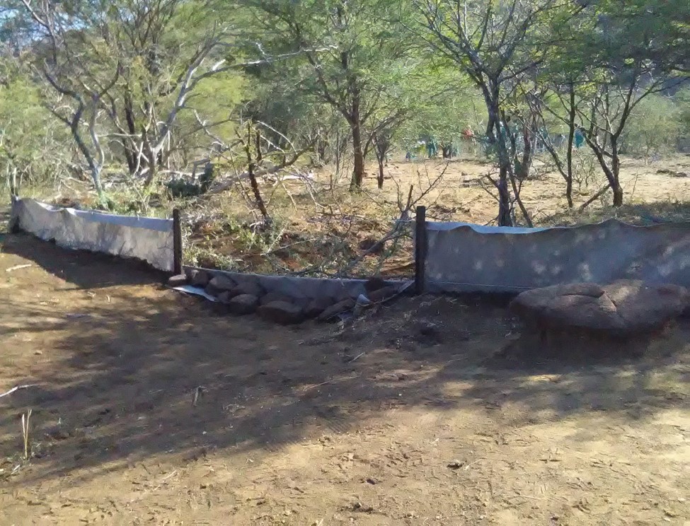
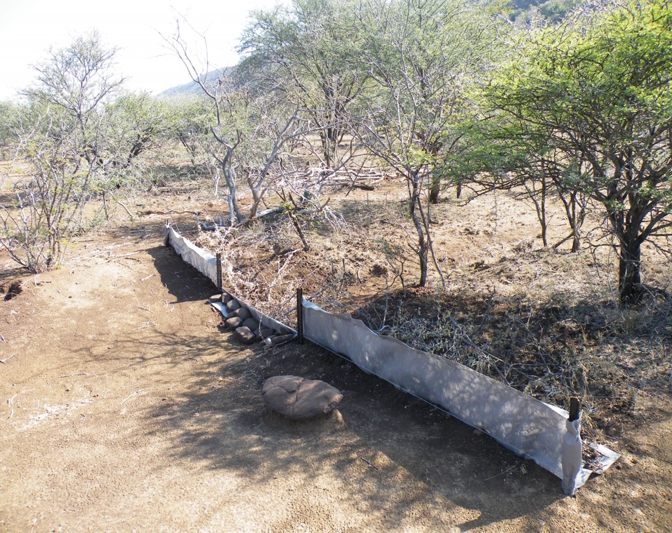
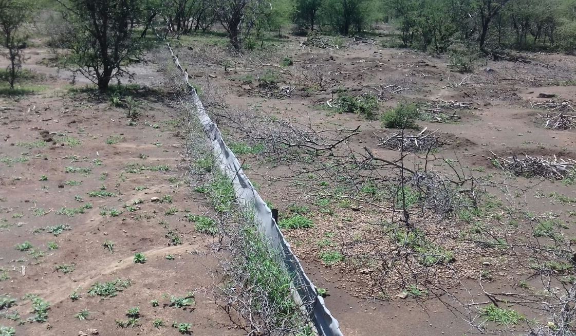
Silt fences together with brush packing were introduced to reduce sediment transport and restoration of gully erosion in the Potlake nature reserve, Limpopo Province, South Africa.
2.2 ការពណ៌នាលម្អិតពីបច្ចេកទេស
ការពណ៌នា:
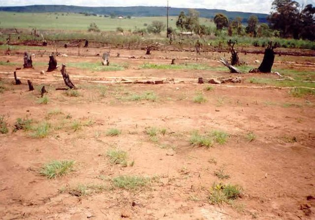
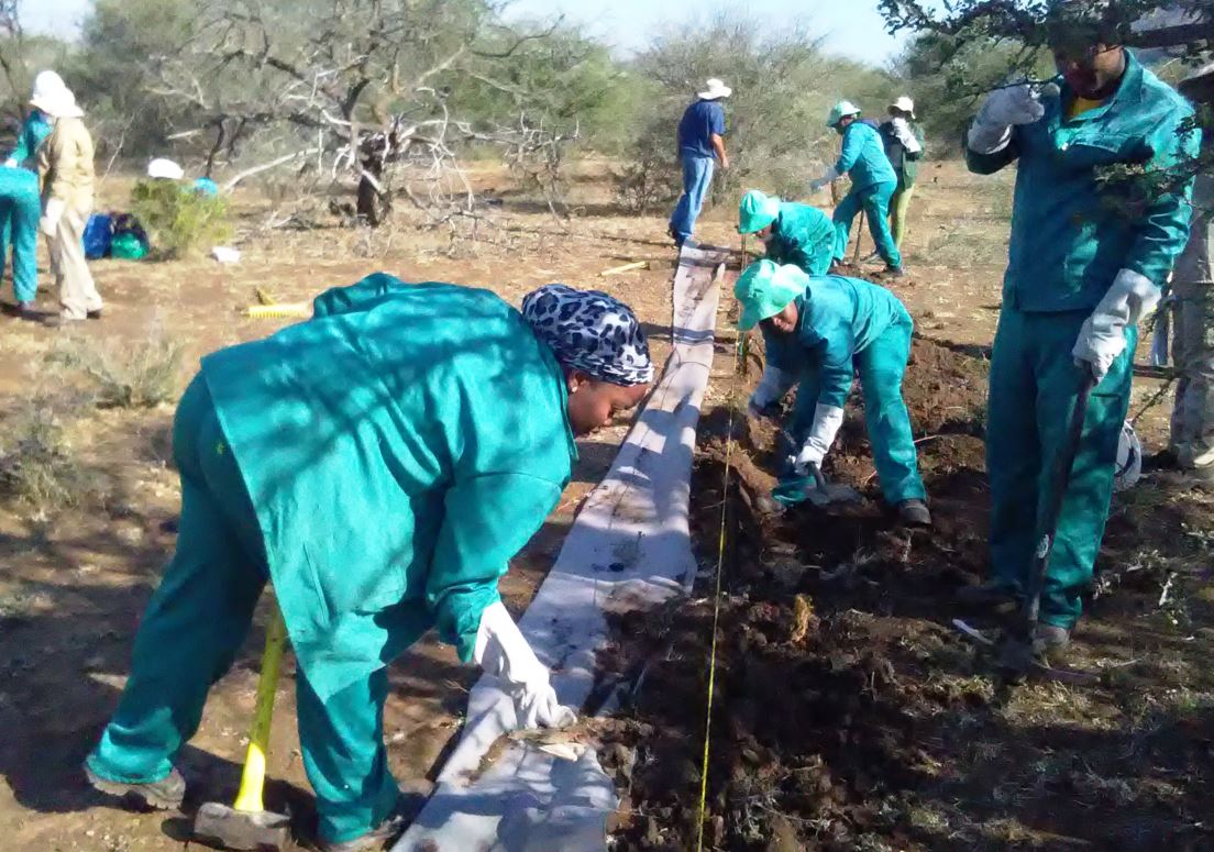
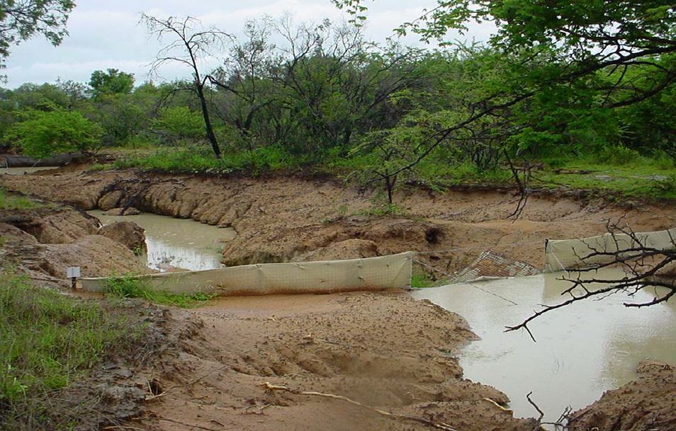
Silt fences, together with brush packing were introduced in the Potlake Game Reserve (2817 ha) in the Limpopo Province of South Africa to rehabilitate areas affected by serious rill and gully erosion. Due to overgrazing on highly erodible soils, gully headcuts are actively migrating upstream. Implementation of the technology leads to enhanced vegetation cover and reduced sediment transport in the gullies. Silt fences are temporary structures and are therefore placed closer together than permanent structures. The placing is such that the silt from the downstream structure builds up against the upstream structure to delay the perishing of the restoration materials. Vegetation must be established in the gully (donga) as soon as possible so that, when the materials decay after about ten years, the area will be restored. Altitudes vary from 1 174 m to 780 m above sea level. The reserve is located in a summer rainfall region and receives an average annual rainfall of 438 mm per year. Clayey duplex soils are prone to both natural and man-induced erosion. The vegetation comprises Central Bushveld vegetation units of the Savanna Biome. Savanna is characterized by a herbaceous layer (usually dominated by grasses) with a woody component. In Southern Africa, Bushveld is an apt description of the vegetation structure, as the vegetation most often does not comprise distinct shrub and tree layers. Instead, the shrubs and trees occur in a matrix with a grass-dominated herb layer. A number of large gullies exist along drainage lines on highly erodible soils. Some of the gullies are up to 1.5 m deep and 5 m wide. A total of around 200 m of silt fences were erected at selected sites in the reserve to retain sediment and to establish vegetation. The following steps were followed in the establishment of the silt fences:
1. Identification of priority sites to erect the silt fences - using Google Earth imagery and field surveys.
2. Acquisition of restoration material and training of local community members on the implementation of the technology (training by Mr. Buckle at that stage from the Department).
3. Levelling of the area where fences would be erected.
4. Construction of fences.
5. Brush packing (upstream of fence) stone packing (downstream in the gully).
2.3 រូបភាពនៃបច្ចេកទេស
វិចិត្រសាលប្រព័ន្ធផ្សព្វផ្សាយ
2.5 ប្រទេស/តំបន់/ទីតាំងកន្លែង ដែលបច្ចេកទេសត្រូវបានអនុវត្ត និងបានគ្រប់ដណ្តប់ដោយការវាយតម្លៃនេះ
ប្រទេស:
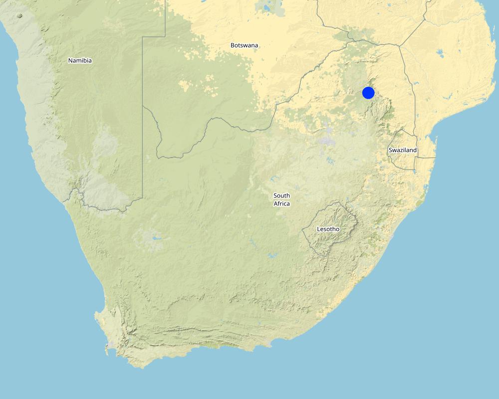
ប្រទេសអាហ្រ្វិកខាងត្បូង
តំបន់/រដ្ឋ/ខេត្ត:
Limpopo Province
បញ្ជាក់បន្ថែមពីលក្ខណៈនៃទីតាំង:
Potlake nature reserve
បញ្ជាក់ពីការសាយភាយនៃបច្ចេកទេស:
- ត្រូវបានផ្សព្វផ្សាយត្រឹមតំបន់មួយ
ប្រសិនបើមិនច្បាស់ពីទំហំផ្ទៃដី សូមធ្វើការប៉ាន់ប្រម៉ាណ:
- 1-10 គម2
តើបច្ចេកទេស (មួយ ឬច្រើន) ទាំងនោះស្ថិតនៅក្នុងតំបន់ការពារជាអចិន្ត្រៃយ៍ណាមួយដែរឬទេ?
បាទ/ចា៎
បើបាទ/ច៎ា សូមបញ្ជាក់:
Located in the Potlake nature reserve
Map
×2.6 កាលបរិច្ឆេទនៃការអនុវត្ត
ប្រសិនបើមិនច្បាស់ឆ្នាំ សូមបញ្ជាក់កាលបរិច្ឆេទដែលប្រហាក់ប្រហែល:
- តិចជាង 10ឆ្នាំមុន (ថ្មី)
2.7 ការណែនាំពីបច្ចេកទេស
សូមបញ្ជាក់តើបច្ចេកទេសត្រូវបានណែនាំឱ្យអនុវត្តដោយរបៀបណា:
- តាមរយៈគម្រោង / អន្តរាគមន៍ពីខាងក្រៅ
3. ចំណាត់ថ្នាក់នៃបច្ចេកទេស SLM
3.1 គោលបំណងចម្បង (១ ឬច្រើន) នៃបច្ចេកទេសនេះ
- កាត់បន្ថយ, បង្ការ, ស្តារឡើងវិញនូវការធ្លាក់ចុះគុណភាពដី
- អភិរក្សប្រព័ន្ធអេកូឡូស៊ី
- ការពារតំបន់ទីជម្រាល/តំបន់ខ្សែទឹកខាងក្រោមបញ្ចូលជាមួយបច្ចេកទេសផ្សេងទៀត
3.2 ប្រភេទដីប្រើប្រាស់មួយប្រភេទ (ច្រើនប្រភេទ) ដែលបានអនុវត្តបច្ចេកទេស
ដីប្រើប្រាស់ចម្រុះនៅលើដីតែមួយ:
ទេ

ផ្សេងៗ
សូមបញ្ជាក់:
Protected area
កំណត់សម្គាល់:
Potlake nature reserve
3.3 បន្ទាប់ពីអនុវត្តបច្ចេកទេស តើដីប្រើប្រាស់មានការប្រែប្រួលដែររឺទេ?
បន្ទាប់ពីអនុវត្តបច្ចេកទេស តើដីប្រើប្រាស់មានការប្រែប្រួលដែររឺទេ?
- ទេ (បន្តទៅសំណួរ 3.4)
ដីប្រើប្រាស់ចម្រុះនៅលើដីតែមួយ:
ទេ
3.4 ការផ្គត់ផ្គង់ទឹក
ការផ្គត់ផ្គង់ទឹកនៅកន្លែងអនុវត្តបច្ចេកទេស:
- ទឹកភ្លៀង
3.5 ក្រុម SLM ដែលបច្ចេកទេសស្ថិតនៅក្នុង
- ធ្វើឱ្យប្រសើរឡើងគម្របដី/ ដំណាំគម្របដី
- វិធានការអនុវត្តកាត់ទទឹងទីជម្រាល
3.6 វិធានការ SLM ដែលបញ្ចូលនូវបច្ចេកទេស

វិធានការរចនាស័ម្ពន្ធ
- S6: ជញ្ជាំង, របាំង, របងឈើខ្ពស់ៗ
3.7 កំណត់ប្រភេទនៃការធ្លាក់ចុះគុណភាពដីសំខាន់ៗដែលបច្ចេកទេសនេះបានដោះស្រាយ

ការហូរច្រោះដីដោយសារទឹក
- Wt: ការបាត់ដីស្រទាប់លើដោយការហូរច្រោះ
- Wg: ការកកើតឡើងនូវកំទេចកំទីដីស្រទាប់ក្រោម
3.8 ការពារ កាត់បន្ថយ ឬស្តារឡើងវិញនៃការធ្លាក់ចុះគុណភាពដី
បញ្ជាក់ពីគោលដៅរបស់បច្ចេកទេស ដែលផ្តោតទៅការធ្លាក់ចុះគុណភាពដី:
- ការកាត់បន្ថយការធ្លាក់ចុះគុណភាពដី
- ការជួសជុល/ ស្តារឡើងវិញនៃឱនភាពដីធ្ងន់ធ្ងរ
4. បច្ចេកទេសជាក់លាក់ សកម្មភាពអនុវត្ត ធាតុចូល និងថ្លៃដើម
4.1 គំនូសបច្ចេកទេសនៃបច្ចេកទេសនេះ
លក្ខណៈពិសេសនៃបច្ចេកទេស (ទាក់ទងនឺងគំនូរបច្ចេកទេស):
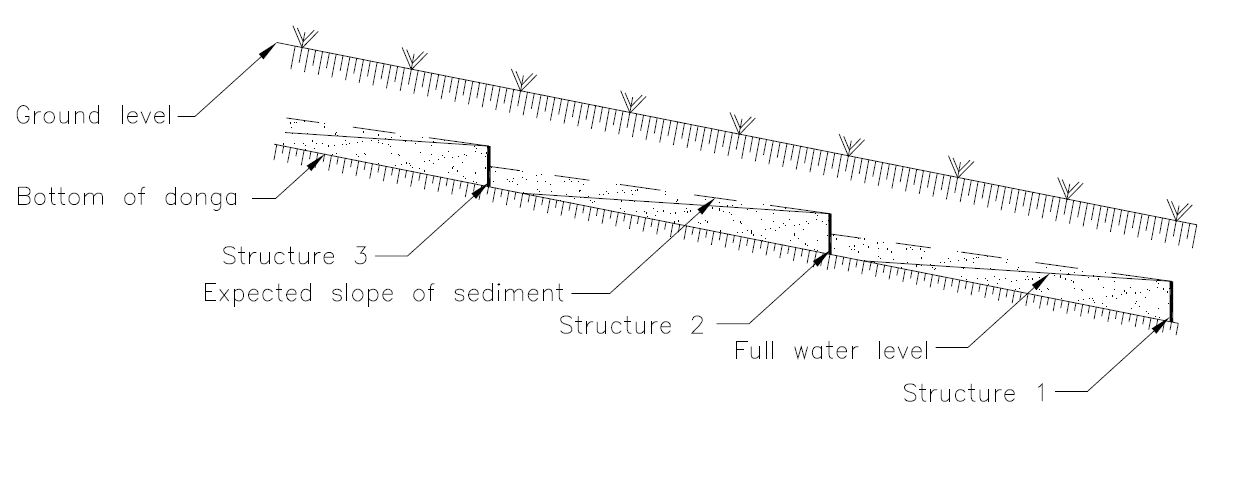
Silt fences are cheap and easy to erect, but the overflow depth must be limited. Silt fences are therefore erected in the wider section of a gully.
ឈ្មោះអ្នកនិពន្ធ:
Jan van Heerden
កាលបរិច្ឆេទ:
01/01/2012
លក្ខណៈពិសេសនៃបច្ចេកទេស (ទាក់ទងនឺងគំនូរបច្ចេកទេស):
Silt fences are temporary structures and are therefore placed closer together than permanent structures. The placing is such that the silt from the downstream structure builds up against the upstream structure to delay the perishing of the restoration materials. Vegetation must be established in the gully (donga) as soon as possible so that, when the materials decay after about ten years, the area will be restored.
ឈ្មោះអ្នកនិពន្ធ:
Jan van Heerden
កាលបរិច្ឆេទ:
01/01/2012
លក្ខណៈពិសេសនៃបច្ចេកទេស (ទាក់ទងនឺងគំនូរបច្ចេកទេស):
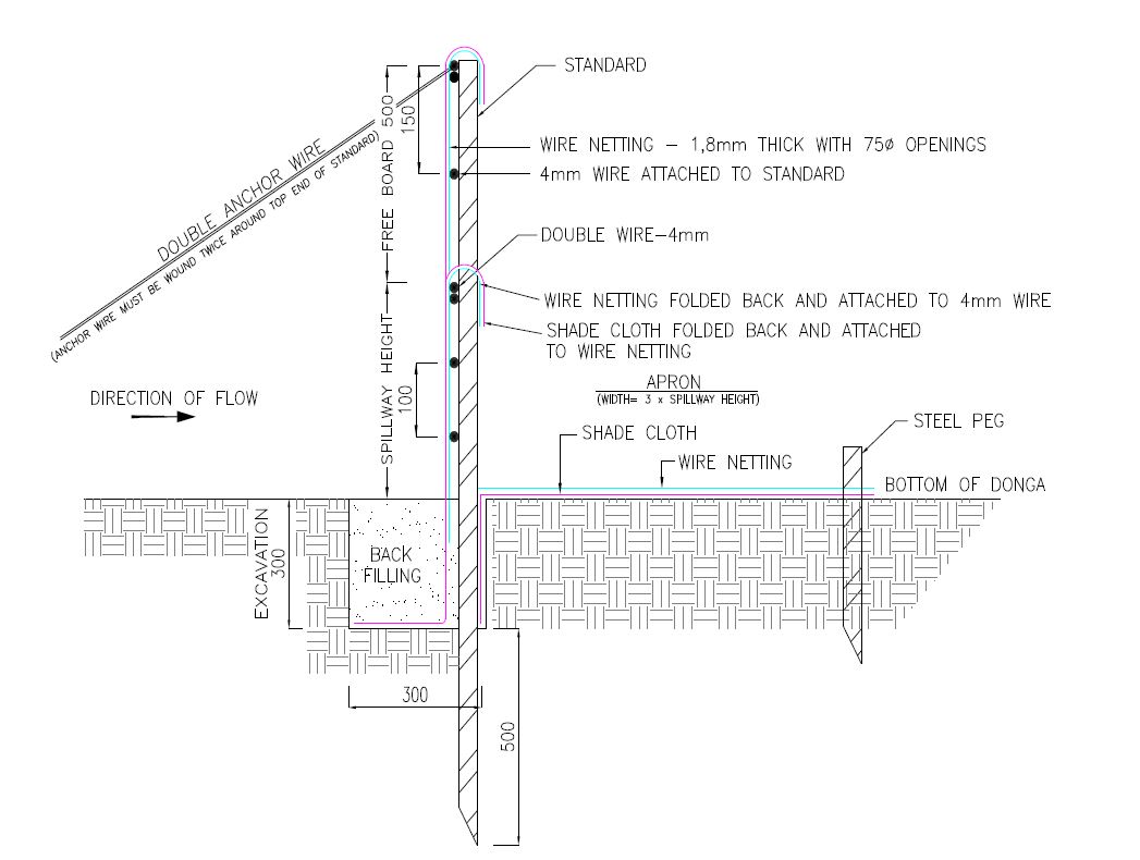
1. Dig a pit trench 300 mm × 300 mm from peg to peg over the entire width of the gully.
2. Drive iron standards (iron pole) in on the sides of the spillway length followed by more standards around 1.5 meters apart - ensure equal spacing between standards (standards must be driven in at least 500 mm deep - ensure that eyes (holes in standards) point upstream and that poles are in line with the others. Place apron on the ground from the excavation downstream. The width of the material must be three times the height of the overflow height and it must be at least 500 mm longer on both sides than the spillway length.
3. Span a 4 mm wire between the spillway poles on the total height of the structure. Tighten only manually and fasten on both sides of the two standards.
4. Drive in two anchor poles in line with the structure on both sides of the donga wall.
5. Saw off or cut heads of standards on the height of the structure’s height. Place anchor wires between two outer poles and anchor poles and tighten.
6. Thread 4 mm wire through on spillway height from side to side and bind to the two poles anchored to the anchor poles.
7. Also place wire between the spillway width poles and the end pole on the structure height and tighten.
8. Span wires from the spillway height wire on 100 mm to 150 mm distances apart, downwards until the last wire is at least 100 mm below the surface.
9. Place netting material (course plastic grid placed behind the filter material) on upstream side of the poles into the excavated pit trench and cut according to shape of the structure.
10. Place filter material flat in the pit trench and in front of the netting material on the upstream side of the poles and cut according to the shape of the structure. Tie the material to the structure with binding wire and fill the pit trench with soil.
11. Place netting material on the apron and tie it to the structure with binding wire and drive in T pegs at strategic places on downstream side.
12. The construction of the drop inlet is built in the same way as a weir structure as close as possible to the head of the donga. The gap between the structure and the donga head is filled with soil and must be filled again after the first rains. The spillway is made ±100 mm higher than the normal ground surface. The structure can be built to a maximum of 1 000 mm from the gully floor to the ground level.
13. Brush packing in front of the silt fence and stone packing downstream of the apron in the gully.
14. In order for silt fences to function more efficiently, it is recommended that that portion of the veld is fenced and withdrawn from grazing. Sowing of grasses or planting of common reed or vetiver grass can speed up the repair process considerably.
ឈ្មោះអ្នកនិពន្ធ:
Jan van Heerden
កាលបរិច្ឆេទ:
01/01/2012
4.2 ព័ត៌មានទូទៅដែលពាក់ព័ន្ធនឹងការគណនាធាតុចូល និងថ្លៃដើម
កំណត់របៀបនៃការគណនាថ្លៃដើម និងធាតុចូល:
- ក្នុងឯកតាបច្ចេកទេស
បញ្ជាក់ឯកតា:
silt fence
បញ្ជាក់ពីទំហំនៃឯកតា (បើពាក់ព័ន្ធ):
6 to 8 meters
ផ្សេងៗ/ រូបិយប័ណ្ណជាតិ (បញ្ជាក់):
Rand
បើពាក់ព័ន្ធសូមកំណត់អត្រាប្តូរប្រាក់ពីដុល្លាទៅរូបិយប័ណ្ណតំបន់ (ឧ. 1 ដុល្លារ = 79.9 រៀលនៃរូបិយប័ណ្ណប្រេស៊ីល) ៖ 1 ដុល្លារ =:
16,0
កំណត់ថ្លៃឈ្នួលជាមធ្យមនៃការជួលកម្លាំងពលកម្មក្នុងមួយថ្ងៃ:
R200
4.3 សកម្មភាពបង្កើត
| សកម្មភាព | រយៈពេល (រដូវកាល) | |
|---|---|---|
| 1. | Preparation of the site to be restored | Winter (outside raining season) |
| 2. | Installation of silt fences followed by brush and stone packing | Winter |
4.4 ថ្លៃដើម និងធាតុចូលដែលត្រូវការសម្រាប់ការបង្កើតបច្ចេកទេស
| បញ្ជាក់ពីធាតុចូល | ឯកតា | បរិមាណ | ថ្លៃដើមក្នុងមួយឯកតា | ថ្លៃធាតុចូលសរុប | % នៃថ្លៃដើមដែលចំណាយដោយអ្នកប្រើប្រាស់ដី | |
|---|---|---|---|---|---|---|
| កម្លាំងពលកម្ម | Unskilled labour (including transport) | Per day | 6,0 | 280,0 | 1680,0 | |
| សម្ភារៈ | Power tools - electric power generator, angle grinder, hammer drill, | Per day | 3,0 | 500,0 | 1500,0 | |
| សម្ភារៈ | Measuring tape, wire tensioning tool, pole driver, heavy and light hammers, pick, spade, pliers and scissors | Per day | 10,0 | 20,0 | 200,0 | |
| សម្ភារៈសាងសង់ | 4mm wire | Per meter | 100,0 | 15,0 | 1500,0 | |
| សម្ភារៈសាងសង់ | Standards | Per piece | 6,0 | 90,0 | 540,0 | |
| សម្ភារៈសាងសង់ | Netting | Per meter | 15,0 | 90,0 | 1350,0 | |
| សម្ភារៈសាងសង់ | Anchor poles | Per piece | 6,0 | 10,0 | 60,0 | |
| សម្ភារៈសាងសង់ | T pegs | Per piece | 20,0 | 20,0 | 400,0 | |
| សម្ភារៈសាងសង់ | Binding wire | Per kg | 5,0 | 40,0 | 200,0 | |
| សម្ភារៈសាងសង់ | Filter material (UV treated shade cloth - 80%) | Per meter | 86,0 | 20,0 | 1720,0 | |
| ថ្លៃដើមសរុបក្នុងការបង្កើតបច្ចេកទេស | 9150,0 | |||||
| ថ្លៃដើមសរុបក្នុងការបង្កើតបច្ចេកទេសគិតជាដុល្លារ | 571,88 | |||||
ប្រសិនបើអ្នកប្រើប្រាស់ដីមិនមានថ្លៃដើម 100% សូមបញ្ជាក់ថានរណាដែលចំណាយថ្លៃដើមដែលនៅសល់:
Department of Forestry, Fisheries and the Environment - South Africa
4.5 សកម្មភាពថែទាំ
| សកម្មភាព | ពេលវេលា/ ភាពញឹកញាប់ | |
|---|---|---|
| 1. | Repair of fences after floods | After flooding event |
4.6 កំណត់ថ្លៃដើមសម្រាប់ការថែទាំ/ សកម្មភាពរបស់បច្ចេកទេស (ក្នុងរយៈពេលមួយឆ្នាំ)
| បញ្ជាក់ពីធាតុចូល | ឯកតា | បរិមាណ | ថ្លៃដើមក្នុងមួយឯកតា | ថ្លៃធាតុចូលសរុប | % នៃថ្លៃដើមដែលចំណាយដោយអ្នកប្រើប្រាស់ដី | |
|---|---|---|---|---|---|---|
| កម្លាំងពលកម្ម | Repair of fences | Per day | 2,0 | 280,0 | 560,0 | |
| សម្ភារៈ | Pliers, hammers, wire tensioning tool, pick, spade, pliers and scissors | Per day | 5,0 | 20,0 | 100,0 | |
| សម្ភារៈសាងសង់ | Binding wire and filter material | Per meter | 4,0 | 150,0 | 600,0 | |
| ថ្លៃដើមសរុបសម្រាប់ការថែទាំដំណាំតាមបច្ចេកទេស | 1260,0 | |||||
| ថ្លៃដើមសរុបសម្រាប់ការថែទាំដំណាំតាមបច្ចេកទេសគិតជាដុល្លារ | 78,75 | |||||
ប្រសិនបើអ្នកប្រើប្រាស់ដីមិនមានថ្លៃដើម 100% សូមបញ្ជាក់ថានរណាដែលចំណាយថ្លៃដើមដែលនៅសល់:
Department of Forestry, Fisheries and the Environment
4.7 កត្តាសំខាន់បំផុតដែលមានឥទ្ធិពលដល់ការចំណាយ
ពណ៌នាពីកត្តាប៉ះពាល់ចម្បងៗទៅលើថ្លៃដើម:
1. Timing - during the raining season these areas could be inaccessible due to clayey soils and water in gullies.
2, Availability of labour.
5. លក្ខណៈបរិស្ថានធម្មជាតិ និងមនុស្ស
5.1 អាកាសធាតុ
បរិមាណទឹកភ្លៀងប្រចាំឆ្នាំ
- < 250 មម
- 251-500 មម
- 501-750 មម
- 751-1,000 មម
- 1,001-1,500 មម
- 1,501-2,000 មម
- 2,001-3,000 មម
- 3,001-4,000 មម
- > 4,000 មម
កំណត់បរិមាណទឹកភ្លៀង (បើដឹង) ជា មីលីម៉ែត្រ:
438,00
តំបន់កសិអាកាសធាតុ
- មានភ្លៀងតិចតួច
5.2 សណ្ឋានដី
ជម្រាលជាមធ្យម:
- រាបស្មើ (0-2%)
- ជម្រាលតិចតួច (3-5%)
- មធ្យម (6-10%)
- ជម្រាលខ្ពស់បន្តិច (11-15%)
- ទីទួល (16-30%)
- ទីទួលចោត (31-60%)
- ទីទួលចោតខ្លាំង (>60%)
ទម្រង់ដី:
- ខ្ពង់រាប
- កំពូលភ្នំ
- ជម្រាលភ្នំ
- ជម្រាលទួល
- ជម្រាលជើងភ្នំ
- បាតជ្រលងភ្នំ
តំបន់តាមរយៈកម្ពស់ :
- 0-100 ម
- 101-500 ម
- 501-1,000 ម
- 1,001-1,500 ម
- 1,501-2,000 ម
- 2,001-2,500 ម
- 2,501-3,000 ម
- 3,001-4,000 ម
- > 4,000 ម
បញ្ជាក់ថាតើបច្ចេកទេសនេះត្រូវបានអនុវត្តន៍នៅក្នុង:
- សណ្ឋានដីផត
5.3 ដី
ជម្រៅដីជាមធ្យម:
- រាក់ខ្លាំង (0-20 សម)
- រាក់ (21-50 សម)
- មធ្យម (51-80 សម)
- ជ្រៅ (81-120 សម)
- ជ្រៅខ្លាំង (> 120 សម)
វាយនភាពដី (ស្រទាប់លើ):
- មធ្យម (ល្បាយ, ល្បាប់)
វាយនភាពដី (> 20 សម ស្រទាប់ក្នុង):
- ម៉ត់/ ធ្ងន់ (ឥដ្ឋ)
សារធាតុសរីរាង្គនៅស្រទាប់ដីខាងលើ:
- មធ្យម (1-3%)
បើអាចសូមភ្ជាប់ការពណ៌នាពីដីឱ្យបានច្បាស់ ឬព័ត៌មានដែលអាចទទួលបាន ឧ. ប្រភេទដី, pH ដី/ ជាតិអាស៊ីត, សមត្ថភាពផ្លាស់ប្តូរកាចុង, វត្តមាននីត្រូសែន, ភាពប្រៃ ។ល។:
A variety of soil forms occur in the reserve and can generally be grouped according to the vegetation unit it supports. Sekhukhune Mountain Bushveld soils are predominantly shallow, rocky and clayey, with lime soils of the Glenrosa and Mispah soil forms often occurring in low-lying areas. Steep slopes commonly have rocky areas with no soil. The Dwars River valley is characterised by prismacutanic horizons with melanic structured diagnostic horizons.
Sekhukhune Plains Bushveld mainly occurs on red apedal clayey soils rich in metals. Soils on the plains are characterised by deep loamy Valsrivier soils. Shallow Glenrosa soils are found on the low-lying, rocky hills. Small mountains commonly have erodible black, melanic structured horizons.
5.4 ទឹកដែលអាចទាញមកប្រើប្រាស់បាន និងគុណភាពទឹក
នីវ៉ូទឹកក្រោមដី:
5-50 ម
ទឹកលើដីដែលអាចទាញយកប្រើប្រាស់បាន:
កម្រិតមធ្យម
គុណភាពទឹក (មិនបានធ្វើប្រត្តិកម្ម):
ទឹកពិសារដែលមានគុណភាពល្អ
គុណភាពទឹក គឺផ្តោតទៅលើ៖:
ទឹកក្រោមដី
តើមានបញ្ហាភាពទឹកប្រៃហូរចូលមកដែរឬទេ?
ទេ
តើទឹកជំនន់កំពុងកើតមាននៅតំបន់នេះដែររឺទេ?
បាទ/ចា៎
5.5 ជីវៈចម្រុះ
ភាពសម្បូរបែបនៃប្រភេទ:
- ខ្ពស់
ភាពសម្បូរបែបនៃទីជម្រក:
- ខ្ពស់
មតិយោបល់ និងលក្ខណៈពិសេសផ្សេងទៀតលើជីវចម្រុះ:
Although the reserve has a very high biodiversity it also includes a potential 16 plant species of conservation concern, of which one is critically endangered and two are endangered.
The reserve has a fair representation of game for its size, but it should be noted that the area is very prone to erosion if its ecological capacity is exceeded. During an aerial census conducted in the reserve a total of 582 head of game was recorded. There are currently 78 verified avian species occurring at the reserve, of which 10 occur on the IUCN Red List of Threatened Species. A total of 33 reptile species has been recorded and a possible 32 amphibian species. No data is currently available for the fish species occurring at the reserve.
5.6 លក្ខណៈនៃអ្នកប្រើប្រាស់ដីដែលអនុវត្តបច្ចេកទេស
ផ្សេងៗ (សូមបញ្ជាក់):
Tourists
ទីផ្សារនៃប្រព័ន្ធផលិតកម្ម:
- ពាណិជ្ជកម្ម/ ទីផ្សារ
ចំណូលក្រៅកសិកម្ម:
- 10-50% នៃចំណូល
កម្រិតជីវភាព:
- មិនល្អ
ឯកជន ឬក្រុម:
- មានបុគ្គលិក (ក្រុមហ៊ុន, រដ្ឋ)
កម្រិតប្រើប្រាស់គ្រឿងយន្ត:
- គ្រឿងយន្ត/ ម៉ាស៊ីន
យេនឌ័រ:
- ស្ត្រី
- បុរស
អាយុរបស់អ្នកប្រើប្រាស់ដី:
- យុវវ័យ
- វ័យកណ្តាល
- មនុស្សចាស់
សូមបញ្ជាក់ពីលក្ខណៈពាក់ព័ន្ធផ្សេងទៀតអំពីអ្នកប្រើប្រាស់ដី:
Nature reserve - tourism
5.7 ទំហំផ្ទៃដីជាមធ្យមនៃដីប្រើប្រាស់ដោយអ្នកប្រើប្រាស់ដី ក្នុងការអនុវត្តបច្ចេកទេស
- < 0.5 ហិកតា
- 0.5-1 ហិកតា
- 1-2 ហិកតា
- 2-5 ហិកតា
- 5-15 ហិកតា
- 15-50 ហិកតា
- 50-100 ហិកតា
- 100-500 ហិកតា
- 500-1,000 ហិកតា
- 1,000-10,000 ហិកតា
- > 10,000 ហិកតា
តើផ្ទៃដីនេះចាត់ទុកជាទំហំកម្រិតណាដែរ ខ្នាតតូច មធ្យម ឬខ្នាតធំ (ធៀបនឹងបរិបទតំបន់)?
- ខ្នាតតូច
5.8 ភាពជាម្ចាស់ដី កម្មសិទ្ធប្រើប្រាស់ដី និងកម្មសិទ្ធប្រើប្រាស់ទឹក
ភាពជាម្ចាស់ដី:
- រដ្ឋ
- State land
- State land
តើកម្មសិទ្ធប្រើប្រាស់ដី គឺផ្អែកលើប្រព័ន្ធច្បាប់បែបបុរាណ?
ទេ
5.9 ការប្រើប្រាស់សេវាកម្ម និងហេដ្ឋារចនាសម្ព័ន្ធ
សុខភាព:
- មិនល្អ
- មធ្យម
- ល្អ
ការអប់រំ:
- មិនល្អ
- មធ្យម
- ល្អ
ជំនួយបច្ចេកទេស:
- មិនល្អ
- មធ្យម
- ល្អ
ការងារ (ឧ. ការងារក្រៅកសិដ្ឋាន):
- មិនល្អ
- មធ្យម
- ល្អ
ទីផ្សារ:
- មិនល្អ
- មធ្យម
- ល្អ
ថាមពល:
- មិនល្អ
- មធ្យម
- ល្អ
ផ្លូវ និងការដឹកជញ្ជូន:
- មិនល្អ
- មធ្យម
- ល្អ
ទឹកផឹក និងអនាម័យ:
- មិនល្អ
- មធ្យម
- ល្អ
សេវាកម្មហិរញ្ញវត្ថុ:
- មិនល្អ
- មធ្យម
- ល្អ
6. ផលប៉ះពាល់ និងការសន្និដ្ឋាន
6.1 ផលប៉ះពាល់ក្នុងបរិវេណអនុវត្តបច្ចេកទេសដែលកើតមាន
ផលប៉ះពាល់លើសេដ្ឋកិច្ចសង្គម
ផលប៉ះពាល់ទៅលើសេដ្ឋកិច្ចសង្គមផ្សេងៗ
Job creation
ផលប៉ះពាល់ទៅលើអេកូឡូស៊ី
ដី
សំណើមដី
គម្របដី
ការបាត់បង់ដី
ការកើនឡើងដី
បញ្ជាក់ពីការប៉ាន់ស្មាននៃផលប៉ះពាល់ក្នុងបរិវេណអនុវត្តបច្ចេកទេស (វាស់វែង):
The on-site impact assessment mainly includes a visual assessment of the amount of sediment trapped behind the silt fences and the establishment of vegetation.
6.2 ផលប៉ះពាល់ក្រៅបរិវេណអនុវត្តបច្ចេកទេសដែលកើតមាន
កំណកល្បាប់ខ្សែទឹកខាងក្រោម
6.3 ភាពប្រឈម និងភាពរួសនៃបច្ចេកទេសទៅនឹងការប្រែប្រួលអាកាសធាតុ និងគ្រោះអាកាសធាតុ/ គ្រោះមហន្តរាយ (ដែលដឹងដោយអ្នកប្រើប្រាស់ដី)
គ្រោះអាកាសធាតុ (មហន្តរាយ)
គ្រោះមហន្តរាយធម្មជាតិ
| លក្ខណៈឆ្លើយតបនៃបច្ចេកទេសទៅនឹងការប្រែប្រួលអាកាសធាតុ | |
|---|---|
| ព្យុះរន្ទះតាមតំបន់ | មធ្យម |
គ្រោះមហន្តរាយទឹក
| លក្ខណៈឆ្លើយតបនៃបច្ចេកទេសទៅនឹងការប្រែប្រួលអាកាសធាតុ | |
|---|---|
| ទឹកជំនន់ដោយទឹកភ្លៀង | មធ្យម |
6.4 ការវិភាគថ្លៃដើម និងអត្ថប្រយោជន៍
តើផលចំណេញ និងថ្លៃដើមត្រូវបានប្រៀបធៀបគ្នាយ៉ាងដូចម្តេច (ទស្សនៈរបស់អ្នកប្រើប្រាស់ដី)?
រយៈពេលខ្លី:
វិជ្ជមាន
រយៈពេលវែង:
វិជ្ជមាន
តើផលចំណេញ និងការថែទាំ/ ជួសជុលត្រូវបានប្រៀបធៀបគ្នាយ៉ាងដូចម្តេច (ទស្សនៈរបស់អ្នកប្រើប្រាស់ដី)?
រយៈពេលខ្លី:
វិជ្ជមាន
រយៈពេលវែង:
វិជ្ជមាន
6.5 ការទទួលយកបច្ចេកទេស
- 11-50%
ក្នុងចំណោមគ្រួសារទាំងអស់ដែលបានអនុវត្តបច្ចេកទេស តើមានប៉ុន្មានគ្រួសារដែលចង់ធ្វើដោយខ្លួនឯង ដោយមិនទទួលបានសម្ភារៈលើកទឹកចិត្ត/ប្រាក់ឧបត្ថម្ភ?:
- 0-10%
6.6 ការបន្សុំា
តើថ្មីៗនេះ បច្ចេកទេសនេះត្រូវបានកែតម្រូវដើម្បីបន្ស៊ាំទៅនឹងស្ថានភាពប្រែប្រួលដែរឬទេ?
ទេ
6.7 ភាពខ្លាំង/ គុណសម្បត្តិ/ ឱកាសនៃបច្ចេកទេស
| ភាពខ្លាំង/ គុណសម្បត្តិ/ ឱកាសនៅកន្លែងរបស់អ្នកប្រើប្រាស់ដី |
|---|
| Very important to stabilise landscapes. |
| Helps to improve the habitat for wildlife, biodiversity in the protected area. |
| ភាពខ្លាំង/ គុណសម្បត្តិ/ ឱកាស ទស្សនៈរបស់បុគ្គលសំខាន់ៗ |
|---|
| Helps to improve the habitat for wildlife, biodiversity in the protected area. |
6.8 ភាពខ្សោយ/ គុណវិបត្តិ/ ហានិភ័យនៃបច្ចេកទេស និងវិធីសាស្ត្រដោះស្រាយ
| ភាពខ្សោយ/ គុណវិបត្តិ/ ហានិភ័យ ទស្សនៈរបស់អ្នកប្រើប្រាស់ដី | តើបច្ចេកទេសទាំងនោះបានដោះស្រាយបញ្ហាដូចម្តេច? |
|---|---|
| Sensitive to floods | Timing of construction crucial - ready before the floods occur |
| ភាពខ្សោយ/ គុណវិបត្តិ/ ហានិភ័យ ទស្សនៈរបស់អ្នកចងក្រងឬបុគ្គលសំខាន់ៗ | តើបច្ចេកទេសទាំងនោះបានដោះស្រាយបញ្ហាដូចម្តេច? |
|---|---|
| Same as above |
7. ឯកសារយោង និងវេបសាយ
7.1 វិធីសាស្ត្រ/ ប្រភពនៃព័ត៌មាន
- តាមការចុះទីវាល ការស្រាវជ្រាវនៅទីវាល
Revisited the restoration sites by Mr. Van Heerden
- ការសម្ភាសន៍ជាមួយអ្នកជំនាញ/ ឯកទេស
Various discussions with Mr. Van Heerden and Mr. Buckle
- ការចងក្រងពីរបាកការណ៍ និងឯកសារផ្សេងៗទៀតដែលមាន
Silt fence report by Mr. Jan van Heerden (Agricultural Research Council) and the Strategic plan for the Potlake Nature Reserve (Limpopo Department of Economic Development, Environment and Tourism - LEDET)
តើពេលណាដែលទិន្នន័យបានចងក្រង (នៅទីវាល)?
09/09/2021
មតិយោបល់:
Meetings commenced with Mr. Buckle
7.2 ឯកសារយោងដែលបានចេញផ្សាយ
ចំណងជើង អ្នកនិពន្ធ ឆ្នាំ ISBN:
Combating erosion with silt fences, Jan van Heerden, 2006, ISBN 1-919849-76-9
មានប្រភពមកពីណា? ថ្លៃដើមប៉ុន្មាន?
https://www.arc.agric.za/arc-iae/Documents/Publication%20List%20and%20Orderform.pdf
ចំណងជើង អ្នកនិពន្ធ ឆ្នាំ ISBN:
Five-year strategic plan for the Potlake Nature Reserve, Limpopo Province, South Africa
មានប្រភពមកពីណា? ថ្លៃដើមប៉ុន្មាន?
LEDET - no cost
ការតភ្ជាប់ និងម៉ូឌុល
ពង្រីកមើលទាំងអស់ បង្រួមទាំងអស់ការតភ្ជាប់
Working for Water [ប្រទេសអាហ្រ្វិកខាងត្បូង]
Government funded restoration/rehabilitation initiative as part of Working for Water project. Aim was to eradicate alien invasive.
- អ្នកចងក្រង៖ Klaus Kellner
ម៉ូឌុល
គ្មានម៉ូឌុល