Silt fences to trap sediment in areas affected by gully erosion [Өмнөд Африк ]
- Шинийг нээх:
- Шинэчлэх:
- Мэдээлэл цуглуулсан: Dirk Pretorius
- Редактор: –
- Хянагчид: William Critchley, Rima Mekdaschi Studer
Silt fences
technologies_6174 - Өмнөд Африк
Бүлгүүдийг үзэх
Бүгдийг харуулах Бүгдийг хаах1. Ерөнхий мэдээлэл
1.2 Технологийг үнэлэх, баримтжуулах ажилд хамаарах мэдээлэл өгсөн хүмүүс, байгууллагуудын холбоо барих мэдээлэл
Мэдээлэл өгсөн хүн (с)
ГТМ мэргэжилтэн :
Van Heerden Heinrich
Eco Rhythm Management
Өмнөд Африк
Технологи баримтжуулах/үнэлэх ажилд дэмжлэг үзүүлсэн төслийн нэр (шаардлагатай бол)
Working for Water (Natural Resource Management Programmes – DEA, South Africa)?1.3 WOCAT-аар баримтжуулсан өгөгдлийг ашиглахтай холбоотой нөхцөл
Эмхэтгэгч болон гол мэдээлэгч хүн(хүмүүс) WOCAT аргачлалаар баримтжуулсан мэдээллийг ашиглахтай холбоотой нөхцлийг хүлээн зөвшөөрсөн.
Тийм
1.4 Технологи тогтвортой гэдгийг баталгаажуулах
Энэ технологи азрын доройтлыг бууруулахад нөлөө үзүүлэхгүй тул газрын тогтвортой менежментийн технологи болж чадахгүй юу?
Үгүй
1.5 ГТМ Арга барилын Асуулга (ууд) руу хандах (WOCAT ашиглан баримтжуулсан)
Working for Water [Өмнөд Африк ]
Government funded restoration/rehabilitation initiative as part of Working for Water project. Aim was to eradicate alien invasive.
- Мэдээлэл цуглуулсан: Klaus Kellner
2. ГТМ Технологийн тодорхойлолт
2.1 Технологийн товч тодорхойлолт
Технологийн тодорхойлолт:
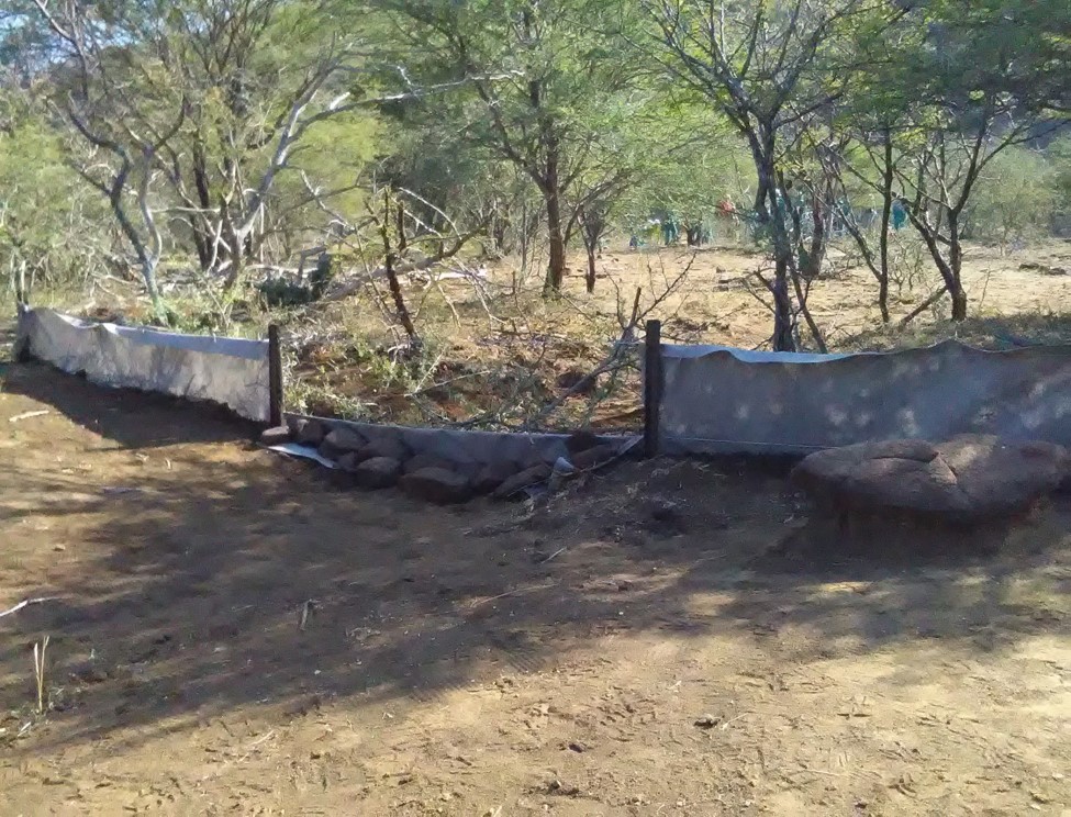
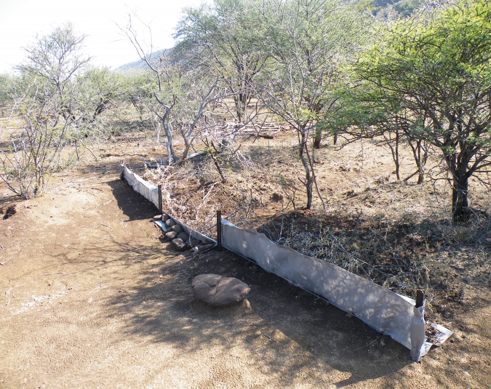
Silt fences together with brush packing were introduced to reduce sediment transport and restoration of gully erosion in the Potlake nature reserve, Limpopo Province, South Africa.
2.2 Технологийн дэлгэрэнгүй тайлбар
Тодорхойлолт:
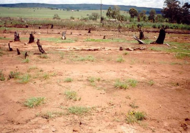
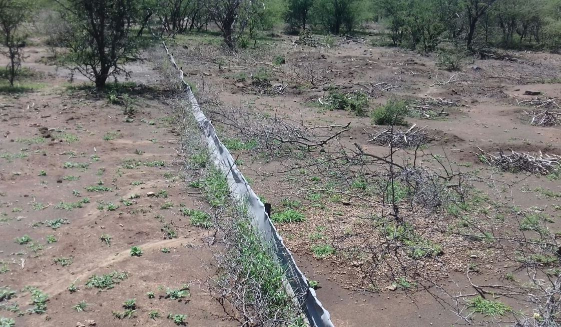
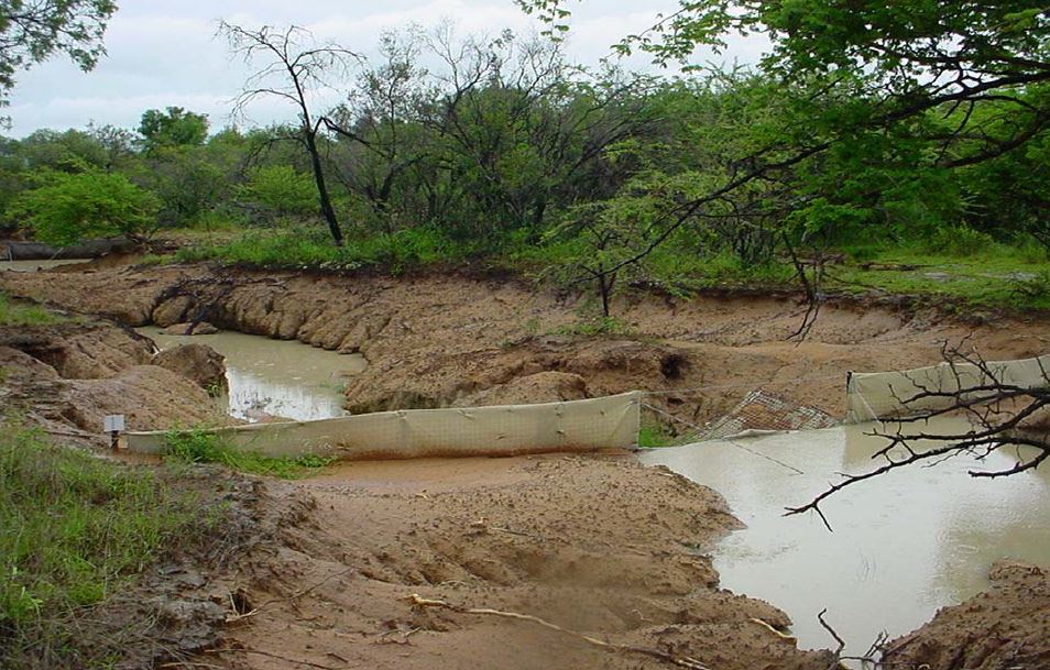
Silt fences, together with brush packing were introduced in the Potlake Game Reserve (2817 ha) in the Limpopo Province of South Africa to rehabilitate areas affected by serious rill and gully erosion. Due to overgrazing on highly erodible soils, gully headcuts are actively migrating upstream. Implementation of the technology leads to enhanced vegetation cover and reduced sediment transport in the gullies. Silt fences are temporary structures and are therefore placed closer together than permanent structures. The placing is such that the silt from the downstream structure builds up against the upstream structure to delay the perishing of the restoration materials. Vegetation must be established in the gully (donga) as soon as possible so that, when the materials decay after about ten years, the area will be restored. Altitudes vary from 1 174 m to 780 m above sea level. The reserve is located in a summer rainfall region and receives an average annual rainfall of 438 mm per year. Clayey duplex soils are prone to both natural and man-induced erosion. The vegetation comprises Central Bushveld vegetation units of the Savanna Biome. Savanna is characterized by a herbaceous layer (usually dominated by grasses) with a woody component. In Southern Africa, Bushveld is an apt description of the vegetation structure, as the vegetation most often does not comprise distinct shrub and tree layers. Instead, the shrubs and trees occur in a matrix with a grass-dominated herb layer. A number of large gullies exist along drainage lines on highly erodible soils. Some of the gullies are up to 1.5 m deep and 5 m wide. A total of around 200 m of silt fences were erected at selected sites in the reserve to retain sediment and to establish vegetation. The following steps were followed in the establishment of the silt fences:
1. Identification of priority sites to erect the silt fences - using Google Earth imagery and field surveys.
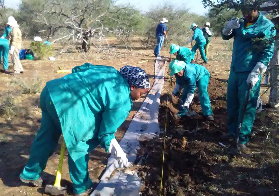
2. Acquisition of restoration material and training of local community members on the implementation of the technology (training by Mr. Buckle at that stage from the Department).
3. Levelling of the area where fences would be erected.
4. Construction of fences.
5. Brush packing (upstream of fence) stone packing (downstream in the gully).
2.3 Технологийн гэрэл зураг
Медиа галерей
2.5 Энэ үнэлгээнд хамрагдсан технологийг хэрэгжүүлсэн улс орон / бүс нутаг / байршил
Улс :
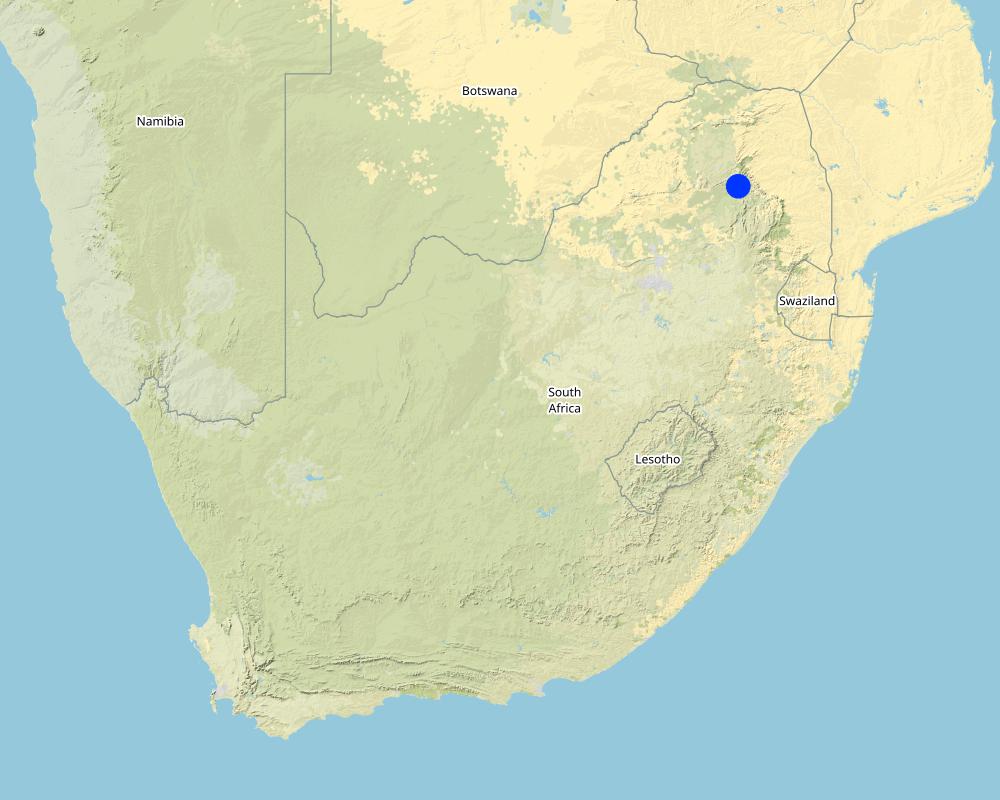
Өмнөд Африк
Улс/аймаг/сум:
Limpopo Province
Байршлын дэлгэрэнгүй тодорхойлолт:
Potlake nature reserve
Технологи өргөн дэлгэрсэн эсхийг тодорхойл:
- газар дээр жигд тархсан
Хэрэв талбайн хэмжээ тодорхойгүй бол талбайн хэмжээг ойролцоогоор тодорхойлно уу.
- 1-10 км2
Технологи(иуд) нэвтрүүлсэн талбай байнгын хамгаалалттай газар нутагт байрладаг уу?
Тийм
Хэрэв тийм бол, тодруулна уу:
Located in the Potlake nature reserve
Map
×2.6 Хэрэгжих огноо
Байгуулсан тодорхой оныг мэдэхгүй бол баримжаа хугацааг тодорхойл:
- <10 жилийн өмнө (саяхны)
2.7 Технологийн танилцуулга
Технологийг хэрхэн нэвтрүүлснийг тодорхойл:
- Гадны төсөл/хөтөлбөрийн дэмжлэгтэйгээр
3. ГТМ технологийн ангилал
3.1 Технологийн үндсэн зорилго (д)
- Газрын доройтлыг бууруулах, сэргийлэх, нөхөн сэргээх
- Экосистемийг хамгаалах
- Сав газар / доод урсгалыг хамгаалах - бусад технологитой хослуулах
3.2 Технологи хэвтрүүлсэн газрын одоогийн газар ашиглалтын хэлбэр(д)
Нэг газр нутгийн хэмжээнд хэрэгжих холимог газар ашиглалт:
Үгүй

Бусад
Тодорхойлно уу:
Protected area
Нэмэлт тодотгол:
Potlake nature reserve
3.3 Технологи хэрэгжүүлснээс газар ашиглалтад өөрчлөлт гарсан уу?
Технологи хэрэгжүүлснээс газар ашиглалтад өөрчлөлт гарсан уу?
- Үгүй (3.4 хариулт руу шилжинэ үү)
Нэг газр нутгийн хэмжээнд хэрэгжих холимог газар ашиглалт:
Үгүй
3.4 Усан хангамж
Технологи хэрэгжүүлсэн газрын усан хангамж:
- Байгалийн усалгаатай
3.5 Технологи ГТМ-ийн аль бүлэгт хамаарах
- гадаргын/ ургамал бүрхэвч сайжрах
- Налуугийн хөндөлн огтлолын дагуух арга хэмжээ
3.6 Технологийг бүрдүүлэх ГТМ арга хэмжээ

Барилга байгууламжийн арга хэмжээ
- S6: Хашаа, саад, явган хашлага, хашаа
3.7 Технологийн шийдвэрлэсэн газрын доройтлын үндсэн төрлүүд

Хөрс усаар эвдрэх
- Wt: Хөрсний гадаргын угаагдал
- Wg: Гуу жалгын элэгдэл
3.8 Газрын доройтлоос урьдчилан сэргийлэх, сааруулах ба нөхөн сэргээх
Газрын доройтолтой холбоотойгоор Технологи ямар зорилго тавьсан болохыг тодорхойл:
- Газрын доройтлыг багасгах сааруулах
- Хүчтэй доройтсон газрыг нөхөн сэргээх/ сайжруулах
4. Техникийн нөхцөл, хэрэгжилтийн үйл ажиллагаа, материал ба зардал
4.1 Технологийн техникийн зураг
Техник тодорхойлолт (техник зурагтай уялдана):
Silt fences are cheap and easy to erect, but the overflow depth must be limited. Silt fences are therefore erected in the wider section of a gully.
Зохиогч:
Jan van Heerden
Он, сар, өдөр:
01/01/2012
Техник тодорхойлолт (техник зурагтай уялдана):
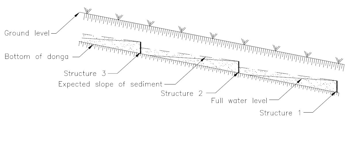
Silt fences are temporary structures and are therefore placed closer together than permanent structures. The placing is such that the silt from the downstream structure builds up against the upstream structure to delay the perishing of the restoration materials. Vegetation must be established in the gully (donga) as soon as possible so that, when the materials decay after about ten years, the area will be restored.
Зохиогч:
Jan van Heerden
Он, сар, өдөр:
01/01/2012
Техник тодорхойлолт (техник зурагтай уялдана):
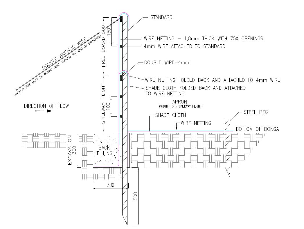
1. Dig a pit trench 300 mm × 300 mm from peg to peg over the entire width of the gully.
2. Drive iron standards (iron pole) in on the sides of the spillway length followed by more standards around 1.5 meters apart - ensure equal spacing between standards (standards must be driven in at least 500 mm deep - ensure that eyes (holes in standards) point upstream and that poles are in line with the others. Place apron on the ground from the excavation downstream. The width of the material must be three times the height of the overflow height and it must be at least 500 mm longer on both sides than the spillway length.
3. Span a 4 mm wire between the spillway poles on the total height of the structure. Tighten only manually and fasten on both sides of the two standards.
4. Drive in two anchor poles in line with the structure on both sides of the donga wall.
5. Saw off or cut heads of standards on the height of the structure’s height. Place anchor wires between two outer poles and anchor poles and tighten.
6. Thread 4 mm wire through on spillway height from side to side and bind to the two poles anchored to the anchor poles.
7. Also place wire between the spillway width poles and the end pole on the structure height and tighten.
8. Span wires from the spillway height wire on 100 mm to 150 mm distances apart, downwards until the last wire is at least 100 mm below the surface.
9. Place netting material (course plastic grid placed behind the filter material) on upstream side of the poles into the excavated pit trench and cut according to shape of the structure.
10. Place filter material flat in the pit trench and in front of the netting material on the upstream side of the poles and cut according to the shape of the structure. Tie the material to the structure with binding wire and fill the pit trench with soil.
11. Place netting material on the apron and tie it to the structure with binding wire and drive in T pegs at strategic places on downstream side.
12. The construction of the drop inlet is built in the same way as a weir structure as close as possible to the head of the donga. The gap between the structure and the donga head is filled with soil and must be filled again after the first rains. The spillway is made ±100 mm higher than the normal ground surface. The structure can be built to a maximum of 1 000 mm from the gully floor to the ground level.
13. Brush packing in front of the silt fence and stone packing downstream of the apron in the gully.
14. In order for silt fences to function more efficiently, it is recommended that that portion of the veld is fenced and withdrawn from grazing. Sowing of grasses or planting of common reed or vetiver grass can speed up the repair process considerably.
Зохиогч:
Jan van Heerden
Он, сар, өдөр:
01/01/2012
4.2 Материал болон зардалд хамаарах ерөнхий мэдээлэл
Үнэ өртөг, оруулсан хувь нэмрийг хэрхэн тооцсоныг тодорхойл:
- Технологийн нэгж тус бүр
Нэгжийг тодорхойл:
silt fence
Нэгж хэмжигдэхүүний хэмжих нэгжийн тодорхойлох (шаардлагатай бол):
6 to 8 meters
бусад/үндэсний мөнгөн нэгж (тодорхойл):
Rand
Хэрэв боломжтой бол үндэсний валютын Америк доллартай харьцах харьцааг бичнэ үү (тухайлбал, 1 ам.дол. = 79,9 Бразил реал): 1 ам.дол. =:
16.0
Хөлсний ажилчны нэг өрдийн ажлын хөлсийг тодорхойл:
R200
4.3 Байгуулах үйл ажиллагаа
| Үйл ажиллагаа | Хугацаа (улирал) | |
|---|---|---|
| 1. | Preparation of the site to be restored | Winter (outside raining season) |
| 2. | Installation of silt fences followed by brush and stone packing | Winter |
4.4 Байгуулалтад шаардагдах зардал ба материал
| Хөрөнгө оруулалтыг дурьдана уу | Хэмжих нэгж | Тоо хэмжээ | Нэгжийн өртөг | Материал бүрийн нийт өртөг | % газар ашиглачаас гарсан зардал | |
|---|---|---|---|---|---|---|
| Хөдөлмөр эрхлэлт | Unskilled labour (including transport) | Per day | 6.0 | 280.0 | 1680.0 | |
| Тоног төхөөрөмж | Power tools - electric power generator, angle grinder, hammer drill, | Per day | 3.0 | 500.0 | 1500.0 | |
| Тоног төхөөрөмж | Measuring tape, wire tensioning tool, pole driver, heavy and light hammers, pick, spade, pliers and scissors | Per day | 10.0 | 20.0 | 200.0 | |
| Барилгын материал | 4mm wire | Per meter | 100.0 | 15.0 | 1500.0 | |
| Барилгын материал | Standards | Per piece | 6.0 | 90.0 | 540.0 | |
| Барилгын материал | Netting | Per meter | 15.0 | 90.0 | 1350.0 | |
| Барилгын материал | Anchor poles | Per piece | 6.0 | 10.0 | 60.0 | |
| Барилгын материал | T pegs | Per piece | 20.0 | 20.0 | 400.0 | |
| Барилгын материал | Binding wire | Per kg | 5.0 | 40.0 | 200.0 | |
| Барилгын материал | Filter material (UV treated shade cloth - 80%) | Per meter | 86.0 | 20.0 | 1720.0 | |
| Технологи бий болгох нийт үнэ өртөг | 9150.0 | |||||
| Технологи бий болгох нийт үнэ өртөг, ам.доллар | 571.88 | |||||
Хэрэв газар ашиглагчаас нийт өртөгийн 100%хүрэхгүй зардал гарсан бол хэн үлдсэн хөрөнгө оруулалтыг хийснийг тодорхойл.
Department of Forestry, Fisheries and the Environment - South Africa
4.5 Засвар үйлчилгээ / давтагдах үйл ажиллагаа
| Үйл ажиллагаа | Хугацаа/ давтамж | |
|---|---|---|
| 1. | Repair of fences after floods | After flooding event |
4.6 Засвар үйлчилгээ / урсгал үйл ажиллагаанд шаардагдах зардал ба материал (жилээр)
| Хөрөнгө оруулалтыг дурьдана уу | Хэмжих нэгж | Тоо хэмжээ | Нэгжийн өртөг | Материал бүрийн нийт өртөг | % газар ашиглачаас гарсан зардал | |
|---|---|---|---|---|---|---|
| Хөдөлмөр эрхлэлт | Repair of fences | Per day | 2.0 | 280.0 | 560.0 | |
| Тоног төхөөрөмж | Pliers, hammers, wire tensioning tool, pick, spade, pliers and scissors | Per day | 5.0 | 20.0 | 100.0 | |
| Барилгын материал | Binding wire and filter material | Per meter | 4.0 | 150.0 | 600.0 | |
| Технологийг арчилах тордоход шаардагдах нийт үнэ өртөг | 1260.0 | |||||
| Технологи сайжруулах нийт үнэ өртөг, ам.доллар | 78.75 | |||||
Хэрэв газар ашиглагчаас нийт өртөгийн 100%хүрэхгүй зардал гарсан бол хэн үлдсэн хөрөнгө оруулалтыг хийснийг тодорхойл.
Department of Forestry, Fisheries and the Environment
4.7 Зардалд нөлөөлж байгаа хамгийн чухал хүчин зүйл
Өртөг зардлыг тодорхойлох гол хүчин зүйлсийг дурьдана уу:
1. Timing - during the raining season these areas could be inaccessible due to clayey soils and water in gullies.
2, Availability of labour.
5. Хүн, байгалийн хүрээлэн буй орчин
5.1 Уур амьсгал
Жилийн нийлбэр хур тундас
- <250 мм
- 251-500 мм
- 501-750 мм
- 751-1,000 мм
- 1,001-1,500 мм
- 1,501-2,000 мм
- 2,001-3,000 мм
- 3,001-4,000 мм
- > 4,000 мм
Жилийн дундаж хур тунадас (хэрэв мэдэгдэж байвал), мм:
438.00
Агро-уур амьсгалын бүс
- Хагас хуурай
5.2 Байрзүйн зураг
Дундаж налуу:
- Тэгш (0-2 %)
- Бага зэрэг хэвгий (3-5 %)
- Дунд зэрэг хэвгий (6-10 % )
- Долгиорхог (11-15 %)
- Толгодорхог (16-30 %)
- Эгц налуу (31-60 % )
- Огцом эгц налуу (>60 %)
Гадаргын хэлбэр:
- Тэгш өндөрлөг/тэгш тал
- Зоо, хяр
- Уулын энгэр, хажуу
- Ухаа, гүвээ, дов толгод
- Уулын бэл
- Хөндий, хоолой, нам хотос
Өндөршлийн бүс:
- 0-100 м д.т.д
- 101-500 м д.т.д
- 501-1,000 м д.т.д
- 1,001-1,500 м д.т.д
- 1,501-2,000 м д.т.д
- 2,001-2,500 м д.т.д
- 2,501-3,000 м д.т.д
- 3,001-4,000 м д.т.д
- > 4,000 м д.т.д
Технологи дараах асуудалд хандсан эсэхийг тодорхойл:
- хотгор нөхцөл
5.3 Хөрс
Хөрсний дундаж зузаан:
- Маш нимгэн (0-20 см)
- Нимгэн (21-50 см)
- Дунд зэрэг зузаан (51-80 см)
- Зузаан (81-120 cм)
- Маш зузаан (>120 cм)
Хөрсний бүтэц (өнгөн хөрс):
- Дунд зэрэг (шавранцар)
Хөрсний бүтэц (>20 см-ээс доош):
- Хүнд (шаварлаг)
Өнгөн хөрсний органик нэгдэл:
- Дунд (1-3 % )
Боломжтой бол хөрсний бүрэн тодорхойлолт, боломжит мэдээллийг өгнө үү, жишээ нь хөрсний төрөл, хөрсний урвалын орчин/хүчиллэг байдал, катион солилцох чадавхи, азотын хэмжээ, давсжилт г.м.
A variety of soil forms occur in the reserve and can generally be grouped according to the vegetation unit it supports. Sekhukhune Mountain Bushveld soils are predominantly shallow, rocky and clayey, with lime soils of the Glenrosa and Mispah soil forms often occurring in low-lying areas. Steep slopes commonly have rocky areas with no soil. The Dwars River valley is characterised by prismacutanic horizons with melanic structured diagnostic horizons.
Sekhukhune Plains Bushveld mainly occurs on red apedal clayey soils rich in metals. Soils on the plains are characterised by deep loamy Valsrivier soils. Shallow Glenrosa soils are found on the low-lying, rocky hills. Small mountains commonly have erodible black, melanic structured horizons.
5.4 Усны хүртээм ба чанар
Хөрсний усны гүн:
5-50 м
Гадаргын усны хүртээмж:
Дунд зэрэг
Усны чанар (цэвэрлээгүй):
Сайн чанарын ундны ус
Усны чанар гэж:
ул хөрсний ус
Усны давсжилт асуудал болдог уу?
Үгүй
Энэ газар үер усанд автдаг уу?
Тийм
5.5 Биологийн төрөл зүйл
Зүйлийн олон янз байдал:
- Их
Амьдрах орчны олон янз байдал:
- Их
Биологийн олон янз байдлын талаархи тайлбар ба бусад тодорхойлолт:
Although the reserve has a very high biodiversity it also includes a potential 16 plant species of conservation concern, of which one is critically endangered and two are endangered.
The reserve has a fair representation of game for its size, but it should be noted that the area is very prone to erosion if its ecological capacity is exceeded. During an aerial census conducted in the reserve a total of 582 head of game was recorded. There are currently 78 verified avian species occurring at the reserve, of which 10 occur on the IUCN Red List of Threatened Species. A total of 33 reptile species has been recorded and a possible 32 amphibian species. No data is currently available for the fish species occurring at the reserve.
5.6 Технологи нэвтрүүлсэн газар ашиглагчидын онцлог шинж
Бусад (тодорхойлно уу):
Tourists
Үйлдвэрлэлийн системийн зах зээлийн чиг баримжаа:
- Худалдаа наймааны/ зах зээлийн
Фермээс гадуурх орлого:
- Нийт орлогын % 10-50 хувь
Чинээлэг байдлыг харьцангуй түвшин:
- Ядуу
Хувь хүн эсвэл бүлэг:
- Ажилтан (компани, засгийн газар)
Механикжилтын түвшин:
- Механикжсан / мотортой
Хүйс:
- Эмэгтэй
- Эрэгтэй
Газар ашиглагчийн нас:
- Залуус
- Дунд нас
- Ахимаг нас
Газар ашиглагчдын бусад шаардлагатай шинж чанарыг тодорхойл:
Nature reserve - tourism
5.7 Технологи нэвтрүүлэхэд газар ашиглагчийн ашигласан газрын дундаж талбай
- < 0.5 га
- 0.5-1 га
- 1-2 га
- 2-5 га
- 5-15 га
- 15-50 га
- 50-100 га
- 100-500 га
- 500-1,000 га
- 1,000-10,000 га
- > 10,000 га
Энэ нь жижиг, дунд, том оворт тооцогдох уу (орон нутгийн чиг баримжаагаар)?
- Бага-хэмжээний
5.8 Газар эзэмшил, газар ашиглах эрх, ус ашиглах эрх
Газар өмчлөл:
- Төр засаг
- State land
- State land
Газар ашиглалтын эрх уламжлалт эрхзүйн тогтолцоонд суурилдаг уу?
Үгүй
5.9 Дэд бүтэц, үйлчилгээний хүртээмж
эрүүл мэнд:
- Ядуу
- Дунд зэргийн
- Сайн
боловсрол:
- Ядуу
- Дунд зэргийн
- Сайн
техник дэмжлэг:
- Ядуу
- Дунд зэргийн
- Сайн
хөдөлмөр эрхлэлт (жишээ нь, ХАА-аас өөр):
- Ядуу
- Дунд зэргийн
- Сайн
зах зээл:
- Ядуу
- Дунд зэргийн
- Сайн
эрчим хүч:
- Ядуу
- Дунд зэргийн
- Сайн
зам ба тээвэр:
- Ядуу
- Дунд зэргийн
- Сайн
ундны ус ба ариутгал:
- Ядуу
- Дунд зэргийн
- Сайн
санхүүгийн үйлчилгээ:
- Ядуу
- Дунд зэргийн
- Сайн
6. Үр нөлөө ба дүгнэлт
6.1 Технологийн талбай дахь үр нөлөө
Нийгэм-эдийн засгийн үр нөлөө
Бусад нийгэм-эдийн засгийн нөлөөллүүд
Job creation
Экологийн үр нөлөө
Хөрс
хөрсний чийг
хөрсөн бүрхэвч
хөрс алдагдах
хөрс хуримтлагдах
Талбай дахь буюу on-site үр нөлөөний үнэлгээг тодорхойлно уу (хэмжилт):
The on-site impact assessment mainly includes a visual assessment of the amount of sediment trapped behind the silt fences and the establishment of vegetation.
6.2 Технологийн талбайн гадна үзүүлсэн үр нөлөө
урсацын адагт лаг шавар хуримтлагдана
6.3 Технологийн уур амьсгалын өөрчлөлт ба Уур амьсгалаас хамаарах аюул/гамшигт үзэгдэлд өртөх байдал ба эмзэг байдал (газар ашиглагч нарын дүгнэлтээр)
Уур амьсгалаас хамаарах аюулууд (гамшигууд)
Цаг уурын гамшигууд
| Технологи түүний нөлөөг хэрхэн бууруулж байна? | |
|---|---|
| Орон нутгийн аянга цахилгаантай бороо | Дунд зэрэг |
Гидрологийн гамшиг
| Технологи түүний нөлөөг хэрхэн бууруулж байна? | |
|---|---|
| Шар усны үер | Дунд зэрэг |
6.4 Зардал ба үр ашгийн шинжилгээ
Үр ашгийг барилга байгууламжийн зардалтай (газар ашиглагчдын үзэл бодлоор) хэрхэн харьцуулах вэ?
Богино хугацаанд эргэн төлөгдөх байдал:
Эерэг
Урт хугацаанд эргэн төлөгдөх байдал:
Эерэг
Үр ашгийг засвар үйлчилгээ/ урсгал зардалтай (газар ашиглагчдын үзэл бодлоор) хэрхэн харьцуулах вэ?
Богино хугацаанд эргэн төлөгдөх байдал:
Эерэг
Урт хугацаанд эргэн төлөгдөх байдал:
Эерэг
6.5 Технологи нутагшуулах
- 11-50%
Технологийг өөрийн талбайд нэвтрүүлсэн бусад иргэдээс хэд нь үүнийг өөрийн хүчээр, өөрөөр хэлбэл ямар нэг материал, техникийн дэмжлэг, төлбөр авалгүй хийсэн бэ?
- 0-10%
6.6 Дасан зохицох
Хувьсан өөрчлөгдөж буй нөхцөл байдалд Технологид сүүлд ямар нэг шинэчлэл хийгдсэн үү?
Үгүй
6.7 Технологийн давуу тал/боломжууд
| Газар ашиглагчдын тодорхойлсон давуу тал/боломжууд |
|---|
| Very important to stabilise landscapes. |
| Helps to improve the habitat for wildlife, biodiversity in the protected area. |
| Эмхэтгэгч, бусад мэдээлэл өгсөн хүмүүсийн өнцгөөс тодорхойлсон давуу тал/боломжууд |
|---|
| Helps to improve the habitat for wildlife, biodiversity in the protected area. |
6.8 Технологийн дутагдалтай/сул тал/аюул болон тэдгээрийн хэрхэн даван туулах арга замууд
| Газар ашиглагч нарын тодорхойлсон сул тал/ дутагдал/ эрсдэл | Тэдгээрийг хэрхэн даван туулах вэ? |
|---|---|
| Sensitive to floods | Timing of construction crucial - ready before the floods occur |
| Эмхэтгэгч, бусад мэдээлэл өгсөн хүмүүсийн өнцгөөс тодорхойлсон сул тал/ дутагдал/ эрсдэл | Тэдгээрийг хэрхэн даван туулах вэ? |
|---|---|
| Same as above |
7. Ном зүй ба холбоосууд
7.1 Мэдээллийн аргууд / эх сурвалжууд
- Хээрийн уулзалт, судалгаа
Revisited the restoration sites by Mr. Van Heerden
- ГТМ-ийн мэргэжилтэн/шинжээчтэй хийсэн ярилцлага
Various discussions with Mr. Van Heerden and Mr. Buckle
- тайлан болон бусад эх сурвалжийн бүрдэл
Silt fence report by Mr. Jan van Heerden (Agricultural Research Council) and the Strategic plan for the Potlake Nature Reserve (Limpopo Department of Economic Development, Environment and Tourism - LEDET)
Мэдээллийг хэзээ (газар дээр нь) цуглуулсан бэ?
09/09/2021
Тайлбар:
Meetings commenced with Mr. Buckle
7.2 Хүртээмжтэй ном, бүтээлийн ишлэл
Гарчиг, зохиогч, он, ISBN:
Combating erosion with silt fences, Jan van Heerden, 2006, ISBN 1-919849-76-9
Хаанаас авч болох вэ? Зардал?
https://www.arc.agric.za/arc-iae/Documents/Publication%20List%20and%20Orderform.pdf
Гарчиг, зохиогч, он, ISBN:
Five-year strategic plan for the Potlake Nature Reserve, Limpopo Province, South Africa
Хаанаас авч болох вэ? Зардал?
LEDET - no cost
Холбоос ба модулууд
Бүгдийг харуулах Бүгдийг хаахХолбоосууд
Working for Water [Өмнөд Африк ]
Government funded restoration/rehabilitation initiative as part of Working for Water project. Aim was to eradicate alien invasive.
- Мэдээлэл цуглуулсан: Klaus Kellner
Модулууд
Модуль байхгүй байна