Silt fences to trap sediment in areas affected by gully erosion [แอฟริกาใต้]
- ผู้สร้างสรรค์:
- การอัพเดท:
- ผู้รวบรวม: Dirk Pretorius
- ผู้เรียบเรียง: –
- ผู้ตรวจสอบ: William Critchley, Rima Mekdaschi Studer
Silt fences
technologies_6174 - แอฟริกาใต้
ดูส่วนย่อย
ขยายทั้งหมด ย่อทั้งหมด1. ข้อมูลทั่วไป
1.2 รายละเอียดที่ติดต่อได้ของผู้รวบรวมและองค์กรที่เกี่ยวข้องในการประเมินและการจัดเตรียมทำเอกสารของเทคโนโลยี
วิทยากรหลัก
ผู้เชี่ยวชาญ SLM:
Van Heerden Heinrich
Eco Rhythm Management
แอฟริกาใต้
ชื่อของโครงการซึ่งอำนวยความสะดวกในการทำเอกสารหรือการประเมินเทคโนโลยี (ถ้าเกี่ยวข้อง)
Working for Water (Natural Resource Management Programmes – DEA, South Africa)?1.3 เงื่อนไขการใช้ข้อมูลที่ได้บันทึกผ่านทาง WOCAT
ผู้รวบรวมและวิทยากรหลักยอมรับเงื่อนไขเกี่ยวกับการใช้ข้อมูลที่ถูกบันทึกผ่านทาง WOCAT:
ใช่
1.4 การเปิดเผยเรื่องความยั่งยืนของเทคโนโลยีที่ได้อธิบายไว้
เทคโนโลยีที่ได้อธิบายไว้นี้เป็นปัญหาของความเสื่อมโทรมโทรมของที่ดินหรือไม่ จึงไม่ได้รับการยอมรับว่าเป็นเทคโนโลยีเพื่อการจัดการที่ดินอย่างยั่งยืน:
ไม่ใช่
1.5 Reference to Questionnaire(s) on SLM Approaches (documented using WOCAT)
Working for Water [แอฟริกาใต้]
Government funded restoration/rehabilitation initiative as part of Working for Water project. Aim was to eradicate alien invasive.
- ผู้รวบรวม: Klaus Kellner
2. การอธิบายลักษณะของเทคโนโลยี SLM
2.1 การอธิบายแบบสั้น ๆ ของเทคโนโลยี
คำจำกัดความของเทคโนโลยี:
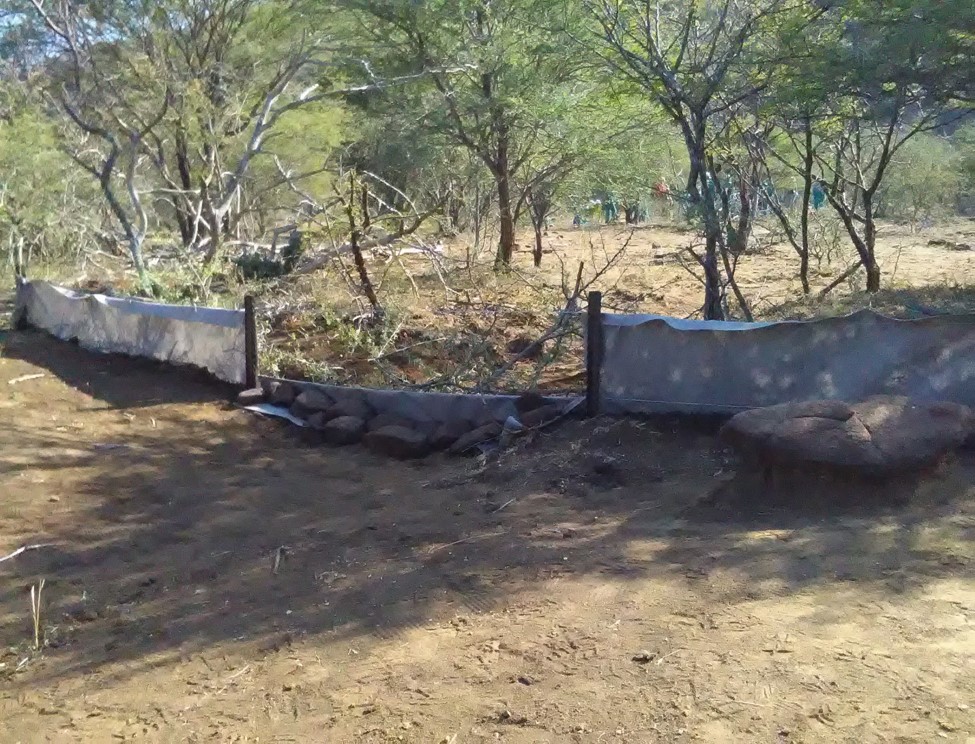
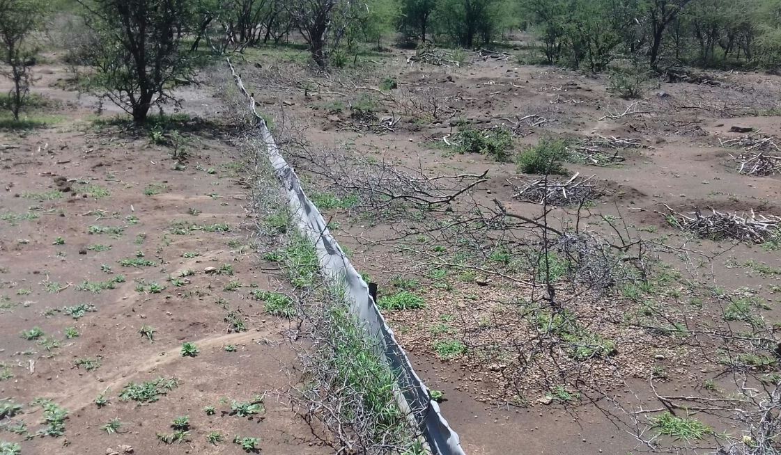
Silt fences together with brush packing were introduced to reduce sediment transport and restoration of gully erosion in the Potlake nature reserve, Limpopo Province, South Africa.
2.2 การอธิบายแบบละเอียดของเทคโนโลยี
คำอธิบาย:
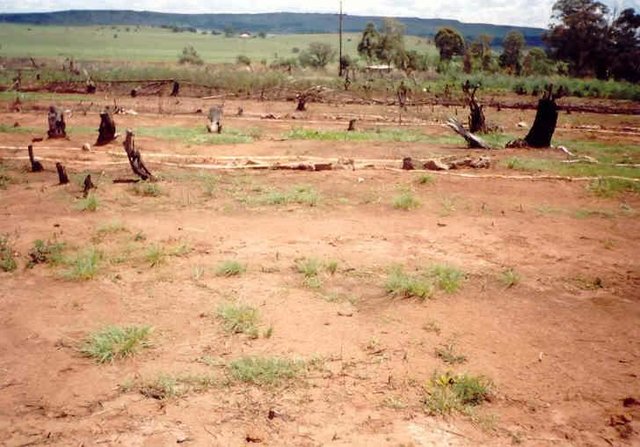
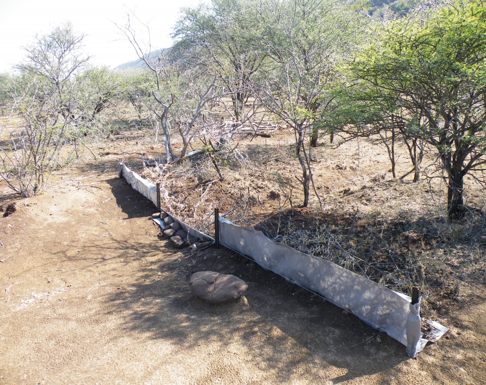
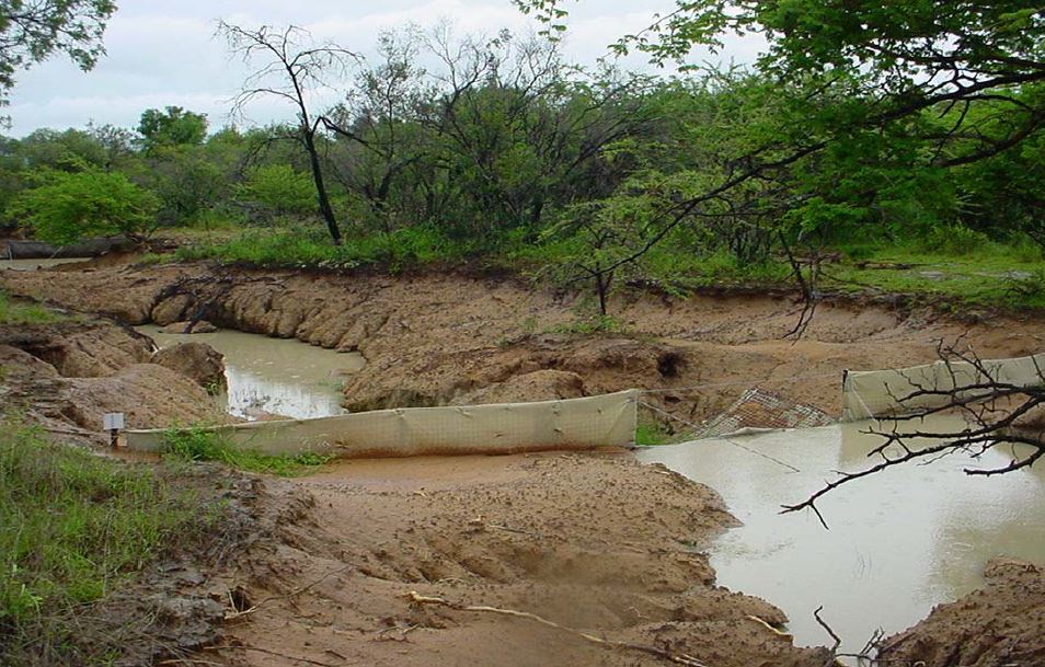
Silt fences, together with brush packing were introduced in the Potlake Game Reserve (2817 ha) in the Limpopo Province of South Africa to rehabilitate areas affected by serious rill and gully erosion. Due to overgrazing on highly erodible soils, gully headcuts are actively migrating upstream. Implementation of the technology leads to enhanced vegetation cover and reduced sediment transport in the gullies. Silt fences are temporary structures and are therefore placed closer together than permanent structures. The placing is such that the silt from the downstream structure builds up against the upstream structure to delay the perishing of the restoration materials. Vegetation must be established in the gully (donga) as soon as possible so that, when the materials decay after about ten years, the area will be restored. Altitudes vary from 1 174 m to 780 m above sea level. The reserve is located in a summer rainfall region and receives an average annual rainfall of 438 mm per year. Clayey duplex soils are prone to both natural and man-induced erosion. The vegetation comprises Central Bushveld vegetation units of the Savanna Biome. Savanna is characterized by a herbaceous layer (usually dominated by grasses) with a woody component. In Southern Africa, Bushveld is an apt description of the vegetation structure, as the vegetation most often does not comprise distinct shrub and tree layers. Instead, the shrubs and trees occur in a matrix with a grass-dominated herb layer. A number of large gullies exist along drainage lines on highly erodible soils. Some of the gullies are up to 1.5 m deep and 5 m wide. A total of around 200 m of silt fences were erected at selected sites in the reserve to retain sediment and to establish vegetation. The following steps were followed in the establishment of the silt fences:
1. Identification of priority sites to erect the silt fences - using Google Earth imagery and field surveys.
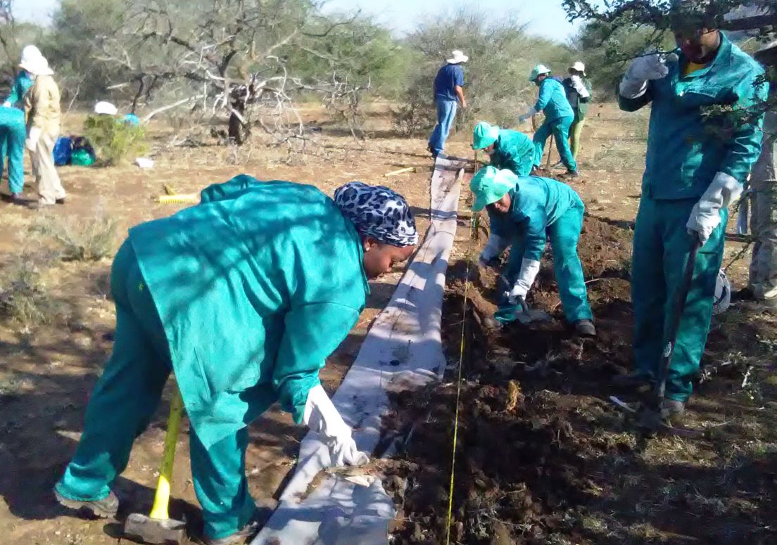
2. Acquisition of restoration material and training of local community members on the implementation of the technology (training by Mr. Buckle at that stage from the Department).
3. Levelling of the area where fences would be erected.
4. Construction of fences.
5. Brush packing (upstream of fence) stone packing (downstream in the gully).
2.3 รูปภาพของเทคโนโลยี
อัลบั้มสื่อบันทึก
2.5 ประเทศภูมิภาค หรือสถานที่ตั้งที่เทคโนโลยีได้นำไปใช้และได้รับการครอบคลุมโดยการประเมินนี้
ประเทศ:
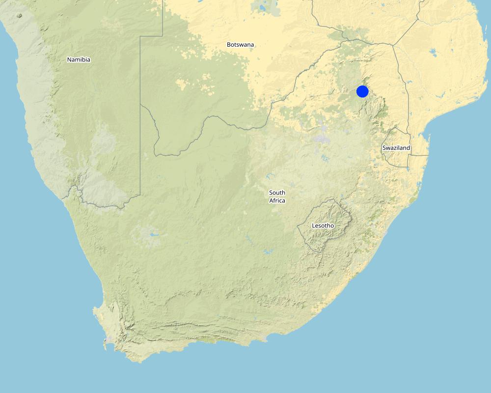
แอฟริกาใต้
ภูมิภาค/รัฐ/จังหวัด:
Limpopo Province
ข้อมูลจำเพาะเพิ่มเติมของสถานที่ตั้ง :
Potlake nature reserve
ระบุการกระจายตัวของเทคโนโลยี:
- กระจายไปอย่างสม่ำเสมอในพื้นที่
If precise area is not known, indicate approximate area covered:
- 1-10 ตร.กม.
Is/are the technology site(s) located in a permanently protected area?
ใช่
ถ้าใช่ ระบุ:
Located in the Potlake nature reserve
Map
×2.6 วันที่การดำเนินการ
ถ้าไม่รู้ปีที่แน่นอน ให้ระบุวันที่โดยประมาณ:
- น้อยกว่า 10 ปี (ไม่นานนี้)
2.7 คำแนะนำของเทคโนโลยี
ให้ระบุว่าเทคโนโลยีถูกแนะนำเข้ามาอย่างไร:
- ทางโครงการหรือจากภายนอก
3. การจัดประเภทของเทคโนโลยี SLM
3.1 วัตถุประสงค์หลักของเทคโนโลยี
- ลด ป้องกัน ฟื้นฟู การเสื่อมโทรมของที่ดิน
- อนุรักษ์ระบบนิเวศน์
- ป้องกันพื้นที่ลุ่มน้ำ/บริเวณท้ายน้ำ โดยร่วมกับเทคโนโลยีอื่นๆ
3.2 ประเภทของการใช้ที่ดินในปัจจุบันที่ได้นำเทคโนโลยีไปใช้
Land use mixed within the same land unit:
ไม่ใช่

อื่น ๆ
ระบุ:
Protected area
ข้อสังเกต:
Potlake nature reserve
3.3 Has land use changed due to the implementation of the Technology?
Has land use changed due to the implementation of the Technology?
- No (Continue with question 3.4)
Land use mixed within the same land unit:
ไม่ใช่
3.4 การใช้น้ำ
การใช้น้ำของที่ดินที่มีการใช้เทคโนโลยีอยู่:
- จากน้ำฝน
3.5 กลุ่ม SLM ที่ตรงกับเทคโนโลยีนี้
- การปรับปรุงดิน / พืชคลุมดิน
- มาตรการปลูกพืชขวางความลาดชัน (cross-slope measure)
3.6 มาตรการ SLM ที่ประกอบกันเป็นเทคโนโลยี

มาตรการอนุรักษ์ด้วยโครงสร้าง
- S6: กำแพง สิ่งกีดขวาง รั้วไม้ รั้วต่างๆ
3.7 รูปแบบหลักของการเสื่อมโทรมของที่ดินที่ได้รับการแก้ไขโดยเทคโนโลยี

การกัดกร่อนของดินโดยน้ำ
- Wt (Loss of topsoil): การสูญเสียดินชั้นบนหรือการกัดกร่อนที่ผิวดิน
- Wg (Gully erosion): การกัดกร่อนแบบร่องธารหรือการทำให้เกิดร่องน้ำเซาะ
3.8 การป้องกัน การลดลง หรือการฟื้นฟูความเสื่อมโทรมของที่ดิน
ระบุเป้าหมายของเทคโนโลยีกับความเสื่อมโทรมของที่ดิน:
- ลดความเสื่อมโทรมของดิน
- ฟื้นฟูบำบัดที่ดินที่เสื่อมโทรมลงอย่างมาก
4. ข้อมูลจำเพาะด้านเทคนิค กิจกรรมการนำไปปฏิบัติใช้ ปัจจัยนำเข้า และค่าใช้จ่าย
4.1 แบบแปลนทางเทคนิคของเทคโนโลยี
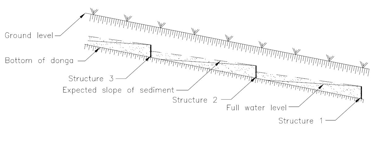
ข้อมูลจำเพาะด้านเทคนิค (แบบแปลนทางเทคนิคของเทคโนโลยี):
Silt fences are cheap and easy to erect, but the overflow depth must be limited. Silt fences are therefore erected in the wider section of a gully.
ผู้เขียน:
Jan van Heerden
วันที่:
01/01/2012
ข้อมูลจำเพาะด้านเทคนิค (แบบแปลนทางเทคนิคของเทคโนโลยี):
Silt fences are temporary structures and are therefore placed closer together than permanent structures. The placing is such that the silt from the downstream structure builds up against the upstream structure to delay the perishing of the restoration materials. Vegetation must be established in the gully (donga) as soon as possible so that, when the materials decay after about ten years, the area will be restored.
ผู้เขียน:
Jan van Heerden
วันที่:
01/01/2012
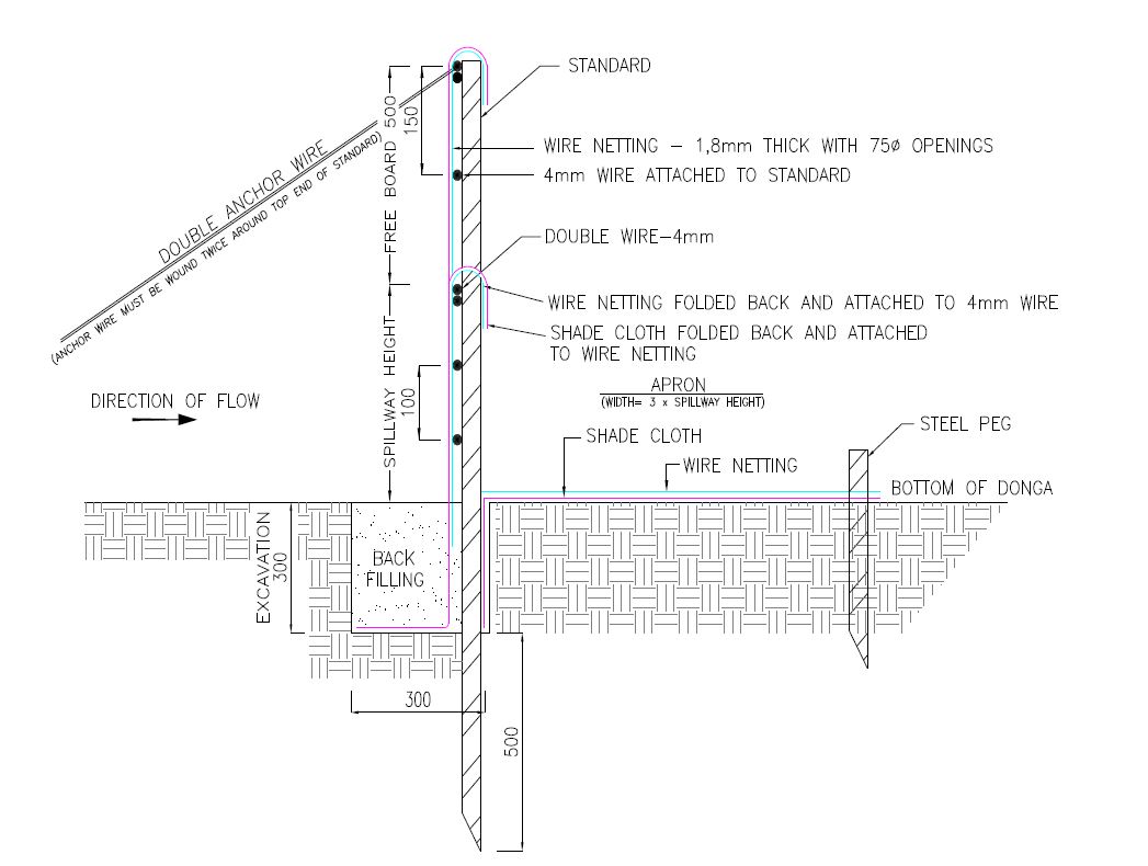
ข้อมูลจำเพาะด้านเทคนิค (แบบแปลนทางเทคนิคของเทคโนโลยี):
1. Dig a pit trench 300 mm × 300 mm from peg to peg over the entire width of the gully.
2. Drive iron standards (iron pole) in on the sides of the spillway length followed by more standards around 1.5 meters apart - ensure equal spacing between standards (standards must be driven in at least 500 mm deep - ensure that eyes (holes in standards) point upstream and that poles are in line with the others. Place apron on the ground from the excavation downstream. The width of the material must be three times the height of the overflow height and it must be at least 500 mm longer on both sides than the spillway length.
3. Span a 4 mm wire between the spillway poles on the total height of the structure. Tighten only manually and fasten on both sides of the two standards.
4. Drive in two anchor poles in line with the structure on both sides of the donga wall.
5. Saw off or cut heads of standards on the height of the structure’s height. Place anchor wires between two outer poles and anchor poles and tighten.
6. Thread 4 mm wire through on spillway height from side to side and bind to the two poles anchored to the anchor poles.
7. Also place wire between the spillway width poles and the end pole on the structure height and tighten.
8. Span wires from the spillway height wire on 100 mm to 150 mm distances apart, downwards until the last wire is at least 100 mm below the surface.
9. Place netting material (course plastic grid placed behind the filter material) on upstream side of the poles into the excavated pit trench and cut according to shape of the structure.
10. Place filter material flat in the pit trench and in front of the netting material on the upstream side of the poles and cut according to the shape of the structure. Tie the material to the structure with binding wire and fill the pit trench with soil.
11. Place netting material on the apron and tie it to the structure with binding wire and drive in T pegs at strategic places on downstream side.
12. The construction of the drop inlet is built in the same way as a weir structure as close as possible to the head of the donga. The gap between the structure and the donga head is filled with soil and must be filled again after the first rains. The spillway is made ±100 mm higher than the normal ground surface. The structure can be built to a maximum of 1 000 mm from the gully floor to the ground level.
13. Brush packing in front of the silt fence and stone packing downstream of the apron in the gully.
14. In order for silt fences to function more efficiently, it is recommended that that portion of the veld is fenced and withdrawn from grazing. Sowing of grasses or planting of common reed or vetiver grass can speed up the repair process considerably.
ผู้เขียน:
Jan van Heerden
วันที่:
01/01/2012
4.2 ข้อมูลทั่วไปเกี่ยวกับการคำนวณปัจจัยนำเข้าและค่าใช้จ่าย
ให้ระบุว่าค่าใช้จ่ายและปัจจัยนำเข้าได้รับการคำนวณอย่างไร:
- ต่อหน่วยเทคโนโลยี
โปรดระบุหน่วย:
silt fence
Specify dimensions of unit (if relevant):
6 to 8 meters
อื่นๆ หรือสกุลเงินประจำชาติ (ระบุ):
Rand
If relevant, indicate exchange rate from USD to local currency (e.g. 1 USD = 79.9 Brazilian Real): 1 USD =:
16.0
ระบุค่าเฉลี่ยของค่าจ้างในการจ้างแรงงานต่อวัน:
R200
4.3 กิจกรรมเพื่อการจัดตั้ง
| กิจกรรม | Timing (season) | |
|---|---|---|
| 1. | Preparation of the site to be restored | Winter (outside raining season) |
| 2. | Installation of silt fences followed by brush and stone packing | Winter |
4.4 ค่าใช้จ่ายของปัจจัยนำเข้าที่จำเป็นสำหรับการจัดตั้ง
| ปัจจัยนำเข้า | หน่วย | ปริมาณ | ค่าใช้จ่ายต่อหน่วย | ค่าใช้จ่ายทั้งหมดต่อปัจจัยนำเข้า | %ของค่าใช้จ่ายที่ก่อให้เกิดขึ้นโดยผู้ใช้ที่ดิน | |
|---|---|---|---|---|---|---|
| แรงงาน | Unskilled labour (including transport) | Per day | 6.0 | 280.0 | 1680.0 | |
| อุปกรณ์ | Power tools - electric power generator, angle grinder, hammer drill, | Per day | 3.0 | 500.0 | 1500.0 | |
| อุปกรณ์ | Measuring tape, wire tensioning tool, pole driver, heavy and light hammers, pick, spade, pliers and scissors | Per day | 10.0 | 20.0 | 200.0 | |
| วัสดุสำหรับก่อสร้าง | 4mm wire | Per meter | 100.0 | 15.0 | 1500.0 | |
| วัสดุสำหรับก่อสร้าง | Standards | Per piece | 6.0 | 90.0 | 540.0 | |
| วัสดุสำหรับก่อสร้าง | Netting | Per meter | 15.0 | 90.0 | 1350.0 | |
| วัสดุสำหรับก่อสร้าง | Anchor poles | Per piece | 6.0 | 10.0 | 60.0 | |
| วัสดุสำหรับก่อสร้าง | T pegs | Per piece | 20.0 | 20.0 | 400.0 | |
| วัสดุสำหรับก่อสร้าง | Binding wire | Per kg | 5.0 | 40.0 | 200.0 | |
| วัสดุสำหรับก่อสร้าง | Filter material (UV treated shade cloth - 80%) | Per meter | 86.0 | 20.0 | 1720.0 | |
| ค่าใช้จ่ายทั้งหมดของการจัดตั้งเทคโนโลยี | 9150.0 | |||||
| Total costs for establishment of the Technology in USD | 571.88 | |||||
ถ้าผู้ใช้ที่ดินรับภาระน้อยกว่า 100% ของค่าใช้จ่าย ให้ระบุว่าใครเป็นผู้รับผิดชอบส่วนที่เหลือ:
Department of Forestry, Fisheries and the Environment - South Africa
4.5 การบำรุงรักษาสภาพหรือกิจกรรมที่เกิดขึ้นเป็นประจำ
| กิจกรรม | ช่วงระยะเวลา/ความถี่ | |
|---|---|---|
| 1. | Repair of fences after floods | After flooding event |
4.6 ค่าใช้จ่ายของปัจจัยนำเข้าและกิจกรรมที่เกิดขึ้นเป็นประจำที่ต้องการการบำรุงรักษา (ต่อปี)
| ปัจจัยนำเข้า | หน่วย | ปริมาณ | ค่าใช้จ่ายต่อหน่วย | ค่าใช้จ่ายทั้งหมดต่อปัจจัยนำเข้า | %ของค่าใช้จ่ายที่ก่อให้เกิดขึ้นโดยผู้ใช้ที่ดิน | |
|---|---|---|---|---|---|---|
| แรงงาน | Repair of fences | Per day | 2.0 | 280.0 | 560.0 | |
| อุปกรณ์ | Pliers, hammers, wire tensioning tool, pick, spade, pliers and scissors | Per day | 5.0 | 20.0 | 100.0 | |
| วัสดุสำหรับก่อสร้าง | Binding wire and filter material | Per meter | 4.0 | 150.0 | 600.0 | |
| ค่าใช้จ่ายทั้งหมดของการบำรุงรักษาสภาพเทคโนโลยี | 1260.0 | |||||
| Total costs for maintenance of the Technology in USD | 78.75 | |||||
ถ้าผู้ใช้ที่ดินรับภาระน้อยกว่า 100% ของค่าใช้จ่าย ให้ระบุว่าใครเป็นผู้รับผิดชอบส่วนที่เหลือ:
Department of Forestry, Fisheries and the Environment
4.7 ปัจจัยสำคัญที่สุดที่มีผลกระทบต่อค่าใช้จ่าย
ปัจจัยสำคัญที่สุดที่มีผลกระทบต่อค่าใช้จ่ายต่างๆ:
1. Timing - during the raining season these areas could be inaccessible due to clayey soils and water in gullies.
2, Availability of labour.
5. สิ่งแวดล้อมทางธรรมชาติและของมนุษย์
5.1 ภูมิอากาศ
ฝนประจำปี
- < 250 ม.ม.
- 251-500 ม.ม.
- 501-750 ม.ม.
- 751-1,000 ม.ม.
- 1,001-1,500 ม.ม.
- 1,501-2,000 ม.ม.
- 2,001-3,000 ม.ม.
- 3,001-4,000 ม.ม.
- > 4,000 ม.ม.
ระบุปริมาณน้ำฝนเฉลี่ยรายปี (ถ้ารู้) :หน่วย ม.ม.
438.00
เขตภูมิอากาศเกษตร
- กึ่งแห้งแล้ง
5.2 สภาพภูมิประเทศ
ค่าเฉลี่ยความลาดชัน:
- ราบเรียบ (0-2%)
- ลาดที่ไม่ชัน (3-5%)
- ปานกลาง (6-10%)
- เป็นลูกคลื่น (11-15%)
- เป็นเนิน (16-30%)
- ชัน (31-60%)
- ชันมาก (>60%)
ธรณีสัณฐาน:
- ที่ราบสูง/ที่ราบ
- สันเขา
- ไหล่เขา
- ไหล่เนินเขา
- ตีนเนิน
- หุบเขา
ระดับความสูง:
- 0-100 เมตร
- 101-500 เมตร
- 501-1,000 เมตร
- 1,001-1,500 เมตร
- 1,501-2,000 เมตร
- 2,001-2,500 เมตร
- 2,501-3,000 เมตร
- 3,001-4,000 เมตร
- > 4,000 เมตร
ให้ระบุถ้าเทคโนโลยีได้ถูกนำไปใช้:
- บริเวณแอ่งบนที่ราบ (concave situations)
5.3 ดิน
ค่าเฉลี่ยความลึกของดิน:
- ตื้นมาก (0-20 ซ.ม.)
- ตื้น (21-50 ซ.ม.)
- ลึกปานกลาง (51-80 ซ.ม.)
- ลึก (81-120 ซ.ม.)
- ลึกมาก (>120 ซ.ม.)
เนื้อดิน (ดินชั้นบน):
- ปานกลาง (ดินร่วน ทรายแป้ง)
เนื้อดินล่าง (> 20 ซ.ม.ต่ำจากผิวดิน):
- ละเอียด/หนัก (ดินเหนียว)
อินทรียวัตถุในดิน:
- ปานกลาง (1-3%)
(ถ้ามี) ให้แนบคำอธิบายเรื่องดินแบบเต็มหรือระบุข้อมูลที่มีอยู่ เช่น ชนิดของดิน ค่า pH ของดินหรือความเป็นกรดของดิน ความสามารถในการแลกเปลี่ยนประจุบวก ไนโตรเจน ความเค็ม เป็นต้น:
A variety of soil forms occur in the reserve and can generally be grouped according to the vegetation unit it supports. Sekhukhune Mountain Bushveld soils are predominantly shallow, rocky and clayey, with lime soils of the Glenrosa and Mispah soil forms often occurring in low-lying areas. Steep slopes commonly have rocky areas with no soil. The Dwars River valley is characterised by prismacutanic horizons with melanic structured diagnostic horizons.
Sekhukhune Plains Bushveld mainly occurs on red apedal clayey soils rich in metals. Soils on the plains are characterised by deep loamy Valsrivier soils. Shallow Glenrosa soils are found on the low-lying, rocky hills. Small mountains commonly have erodible black, melanic structured horizons.
5.4 ความเป็นประโยชน์และคุณภาพของน้ำ
ระดับน้ำใต้ดิน:
5-50 เมตร
น้ำไหลบ่าที่ผิวดิน:
ปานกลาง
คุณภาพน้ำ (ที่ยังไม่ได้บำบัด):
เป็นน้ำเพื่อการดื่มที่ดี
Water quality refers to:
ground water
ความเค็มของน้ำเป็นปัญหาหรือไม่:
ไม่ใช่
กำลังเกิดน้ำท่วมในพื้นที่หรือไม่:
ใช่
5.5 ความหลากหลายทางชีวภาพ
ความหลากหลายทางชนิดพันธุ์:
- สูง
ความหลากหลายของแหล่งที่อยู่:
- สูง
ความคิดเห็นและข้อมูลจำเพาะเพิ่มเติมของความหลากหลายทางชีวภาพ:
Although the reserve has a very high biodiversity it also includes a potential 16 plant species of conservation concern, of which one is critically endangered and two are endangered.
The reserve has a fair representation of game for its size, but it should be noted that the area is very prone to erosion if its ecological capacity is exceeded. During an aerial census conducted in the reserve a total of 582 head of game was recorded. There are currently 78 verified avian species occurring at the reserve, of which 10 occur on the IUCN Red List of Threatened Species. A total of 33 reptile species has been recorded and a possible 32 amphibian species. No data is currently available for the fish species occurring at the reserve.
5.6 ลักษณะของผู้ใช้ที่ดินที่นำเทคโนโลยีไปปฏิบัติใช้
อื่น ๆ (ระบุ):
Tourists
แนวทางการตลาดของระบบการผลิต:
- ทำการค้า/การตลาด
รายได้ที่มาจากนอกฟาร์ม:
- 10-50% ของรายได้ทั้งหมด
ระดับของความมั่งคั่งโดยเปรียบเทียบ:
- จน
เป็นรายบุคคล/ครัวเรือน:
- ลูกจ้าง (บริษัท รัฐบาล)
ระดับของการใช้เครื่องจักรกล:
- การใช้เครื่องจักรหรือเครื่องยนต์
เพศ:
- หญิง
- ชาย
อายุของผู้ใช้ที่ดิน:
- ผู้เยาว์
- วัยกลางคน
- ผู้สูงอายุ
ระบุลักษณะอื่นๆที่เกี่ยวข้องของผู้ใช้ที่ดิน:
Nature reserve - tourism
5.7 Average area of land used by land users applying the Technology
- < 0.5 เฮกตาร์
- 0.5-1 เฮกตาร์
- 1-2 เฮกตาร์
- 2-5 เฮกตาร์
- 5-15 เฮกตาร์
- 15-50 เฮกตาร์
- 50-100 เฮกตาร์
- 100-500 เฮกตาร์
- 500-1,000 เฮกตาร์
- 1,000-10,000 เฮกตาร์
- >10,000 เฮกตาร์
พิจารณาว่าเป็นขนาดเล็ก กลาง หรือขนาดใหญ่ (ซึ่งอ้างอิงถึงบริบทระดับท้องถิ่น):
- ขนาดเล็ก
5.8 กรรมสิทธิ์ในที่ดิน สิทธิในการใช้ที่ดินและสิทธิในการใช้น้ำ
กรรมสิทธิ์ในที่ดิน:
- รัฐ
- State land
- State land
Are land use rights based on a traditional legal system?
ไม่ใช่
5.9 การเข้าถึงบริการและโครงสร้างพื้นฐาน
สุขภาพ:
- จน
- ปานกลาง
- ดี
การศึกษา:
- จน
- ปานกลาง
- ดี
ความช่วยเหลือทางด้านเทคนิค:
- จน
- ปานกลาง
- ดี
การจ้างงาน (เช่น ภายนอกฟาร์ม):
- จน
- ปานกลาง
- ดี
ตลาด:
- จน
- ปานกลาง
- ดี
พลังงาน:
- จน
- ปานกลาง
- ดี
ถนนและการขนส่ง:
- จน
- ปานกลาง
- ดี
น้ำดื่มและการสุขาภิบาล:
- จน
- ปานกลาง
- ดี
บริการด้านการเงิน:
- จน
- ปานกลาง
- ดี
6. ผลกระทบและสรุปคำบอกกล่าว
6.1 ผลกระทบในพื้นที่ดำเนินการ (On-site) จากการใช้เทคโนโลยี
ผลกระทบทางด้านเศรษฐกิจและสังคม
ผลกระทบทางด้านเศรษฐกิจและสังคมอื่น ๆ
Job creation
ผลกระทบด้านนิเวศวิทยา
ดิน
ความชื้นในดิน
สิ่งปกคลุมดิน
การสูญเสียดิน
การสะสมของดิน
Specify assessment of on-site impacts (measurements):
The on-site impact assessment mainly includes a visual assessment of the amount of sediment trapped behind the silt fences and the establishment of vegetation.
6.2 ผลกระทบนอกพื้นที่ดำเนินการ (Off-site) จากการใช้เทคโนโลยี
การทับถมของดินตะกอนพื้นที่ท้ายน้ำ
6.3 การเผชิญและความตอบสนองของเทคโนโลยีต่อการเปลี่ยนแปลงสภาพภูมิอากาศที่ค่อยเป็นค่อยไป และสภาพรุนแรงของภูมิอากาศ / ภัยพิบัติ (ที่รับรู้ได้โดยผู้ใช้ที่ดิน)
สภาพรุนแรงของภูมิอากาศ (ภัยพิบัติ)
ภัยพิบัติทางอุตุนิยมวิทยา
| เทคโนโลยีมีวิธีการรับมืออย่างไร | |
|---|---|
| พายุฝนฟ้าคะนองประจำท้องถิ่น | ปานกลาง |
ภัยพิบัติจากน้ำ
| เทคโนโลยีมีวิธีการรับมืออย่างไร | |
|---|---|
| น้ำท่วมฉับพลัน | ปานกลาง |
6.4 การวิเคราะห์ค่าใช้จ่ายและผลประโยชน์ที่ได้รับ
ผลประโยชน์ที่ได้รับเปรียบเทียบกับค่าใช้จ่ายในการจัดตั้งเป็นอย่างไร (จากมุมมองของผู้ใช้ที่ดิน)
ผลตอบแทนระยะสั้น:
ด้านบวก
ผลตอบแทนระยะยาว:
ด้านบวก
ผลประโยชน์ที่ได้รับเปรียบเทียบกับค่าใช้จ่ายในการบำรุงรักษาหรือต้นทุนที่เกิดขึ้นซ้ำอีก เป็นอย่างไร (จากมุมมองของผู้ใช้ที่ดิน)
ผลตอบแทนระยะสั้น:
ด้านบวก
ผลตอบแทนระยะยาว:
ด้านบวก
6.5 การปรับตัวของเทคโนโลยี
- 11-50%
Of all those who have adopted the Technology, how many did so spontaneously, i.e. without receiving any material incentives/ payments?
- 0-10%
6.6 การปรับตัว
เทคโนโลยีได้รับการปรับเปลี่ยนเมื่อเร็วๆนี้ เพื่อให้ปรับตัวเข้ากับสภาพที่กำลังเปลี่ยนแปลงหรือไม่:
ไม่ใช่
6.7 จุดแข็ง / ข้อได้เปรียบ / โอกาสของเทคโนโลยี
| จุดแข็ง / ข้อได้เปรียบ / โอกาสในทัศนคติของผู้ใช้ที่ดิน |
|---|
| Very important to stabilise landscapes. |
| Helps to improve the habitat for wildlife, biodiversity in the protected area. |
| จุดแข็ง / ข้อได้เปรียบ / โอกาสในทัศนคติของผู้รวบรวมหรือวิทยากรหลัก |
|---|
| Helps to improve the habitat for wildlife, biodiversity in the protected area. |
6.8 จุดอ่อน / ข้อเสียเปรียบ / ความเสี่ยงของเทคโนโลยีและวิธีการแก้ไข
| จุดอ่อน / ข้อเสียเปรียบ / ความเสี่ยงในทัศนคติของผู้ใช้ที่ดิน | มีวิธีการแก้ไขได้อย่างไร |
|---|---|
| Sensitive to floods | Timing of construction crucial - ready before the floods occur |
| จุดอ่อน / ข้อเสียเปรียบ / ความเสี่ยงในทัศนคติของผู้รวบรวมหรือวิทยากรหลัก | มีวิธีการแก้ไขได้อย่างไร |
|---|---|
| Same as above |
7. การอ้างอิงและการเชื่อมต่อ
7.1 วิธีการและแหล่งข้อมูล
- ไปเยี่ยมชมภาคสนาม การสำรวจพื้นที่ภาคสนาม
Revisited the restoration sites by Mr. Van Heerden
- การสัมภาษณ์ผู้เชี่ยวชาญด้าน SLM หรือผู้ชำนาญ
Various discussions with Mr. Van Heerden and Mr. Buckle
- การเก็บรวบรวมมาจากรายงานและเอกสารที่มีอยู่
Silt fence report by Mr. Jan van Heerden (Agricultural Research Council) and the Strategic plan for the Potlake Nature Reserve (Limpopo Department of Economic Development, Environment and Tourism - LEDET)
วันที่เก็บรวบรวมข้อมูล(ภาคสนาม) :
09/09/2021
แสดงความคิดเห็น:
Meetings commenced with Mr. Buckle
7.2 การอ้างอิงถึงสิ่งตีพิมพ์
หัวข้อ, ผู้เขียน, ปี, หมายเลข ISBN:
Combating erosion with silt fences, Jan van Heerden, 2006, ISBN 1-919849-76-9
ชื่อเรื่อง ผู้เขียน ปี ISBN:
https://www.arc.agric.za/arc-iae/Documents/Publication%20List%20and%20Orderform.pdf
หัวข้อ, ผู้เขียน, ปี, หมายเลข ISBN:
Five-year strategic plan for the Potlake Nature Reserve, Limpopo Province, South Africa
ชื่อเรื่อง ผู้เขียน ปี ISBN:
LEDET - no cost
ลิงก์และโมดูล
ขยายทั้งหมด ย่อทั้งหมดลิงก์
Working for Water [แอฟริกาใต้]
Government funded restoration/rehabilitation initiative as part of Working for Water project. Aim was to eradicate alien invasive.
- ผู้รวบรวม: Klaus Kellner
โมดูล
ไม่มีโมดูล