MAPPING, MONITORING, AND MITIGATION OF LAND DEGRADATION IN THE SULTANATE OF OMAN [Оман]
- Создание:
- Обновить:
- Составитель: Laila AlShmali
- Редактор: –
- Рецензенты: William Critchley, Rima Mekdaschi Studer
MAPPING, MONITORING, AND MITIGATION OF LAND DEGRADATION IN THE SULTANATE OF OMAN
approaches_5972 - Оман
Просмотреть разделы
Развернуть все Свернуть все1. Общая информация
1.2 Контактные данные специалистов и организаций, участвующих в описании и оценке Подхода
Ответственный (-ые) специалист (-ы)
Специалист по УЗП:
Al-Sareeria Thuraya
00968 24404762
thuraya.alsareeri@meca.gov.om
Environment Authority
Muscat, Oman
Оман
Специалист по УЗП:
Al-Saadi Saleh Naghmush
00968 24404750
saleh.alsaadi@meca.gov.om
Environment Authority
Muscat, Oman
Оман
researcher:
Al-Wardy Malik
00968 24141224
mwardy@squ.edu.om
Sultan Qaboos University
Muscat, Oman
Оман
Название организации (-ий), содействовавших документированию/оценке Подхода (если применимо)
Sultan Qaboos University (SQU) - Оман1.3 Условия, регламентирующие использование собранных ВОКАТ данных
Когда были собраны данные (на местах)?
15/09/2013
Составитель и ответственный/-ые специалист(-ы) согласны с условиями, регламентирующими использование собранных ВОКАТ данных:
Да
2. Описание Подхода УЗП
2.1 Краткое описание Подхода
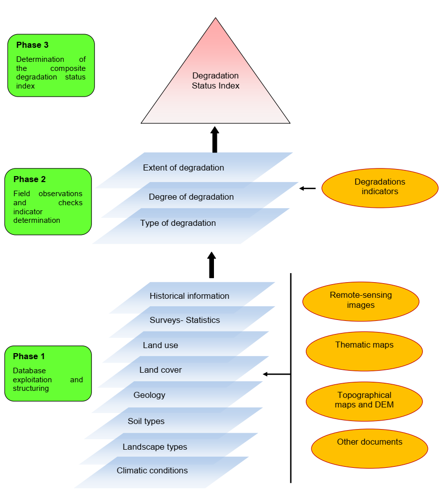
Mapping of land degradation in the Sultanate of Oman to identify areas with various degrees of degradation, and factors and processes causing degradation.
2.2 Подробное описание Подхода
Подробное описание Подхода:
The Environment Authority has implemented land degradation mapping in the Sultanate of Oman in the Governorate of Dhofar, South and North Al Sharqiyah Governorates, and the Governorate of Al Dakhiliyah, in cooperation with Sultan Qaboos University, with the aim of identifying areas with various degrees of degradation and identifying the factors and processes causing degradation.
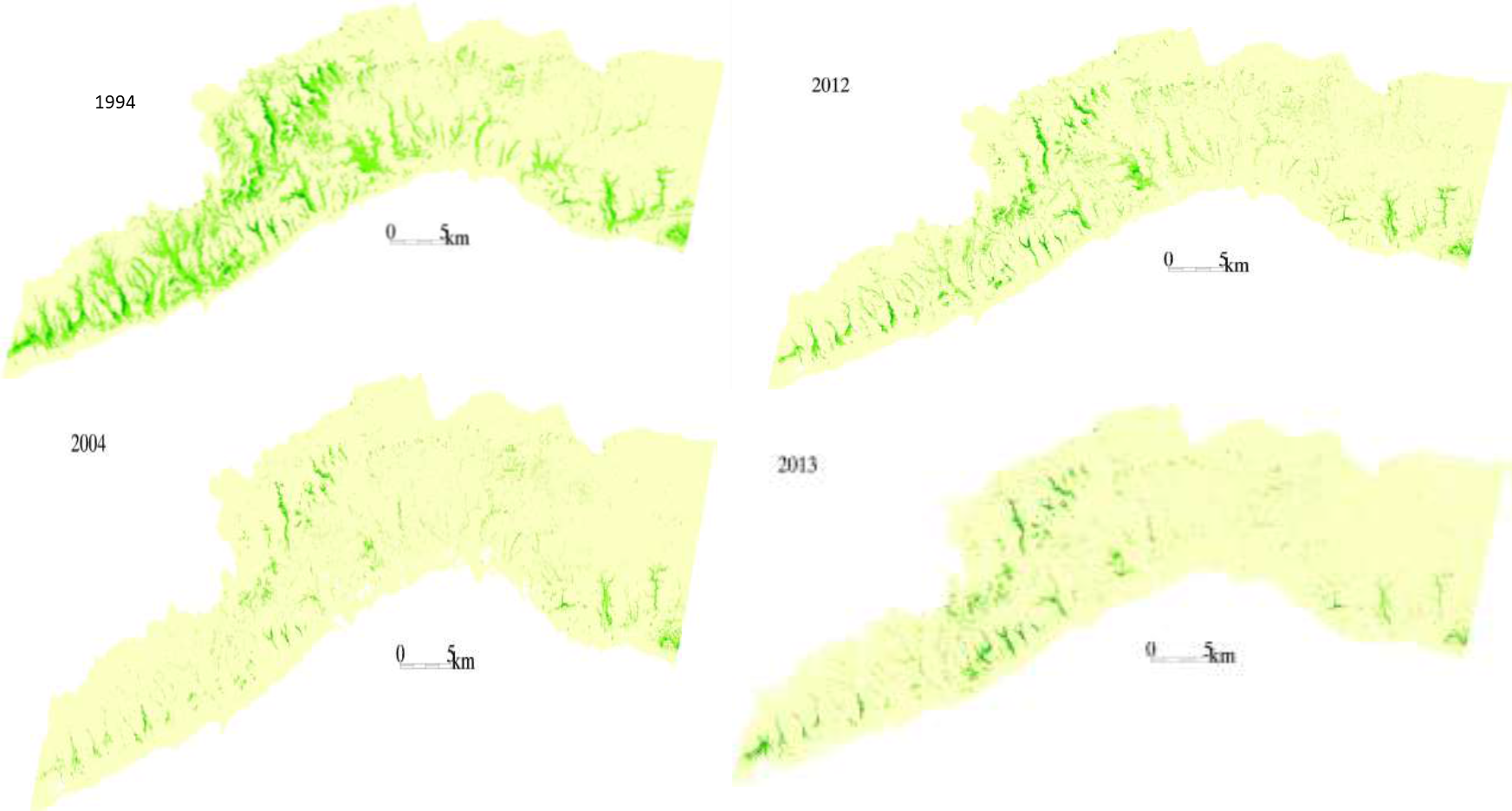
This investigation was based on high-resolution satellite imagery using NDVI as an Index of land degradation in the Dhofar Mountains and the invasion of mesquite (Prosopis juliflora.) in the plain of Salalah, as well as very high resolution aerial and satellite images of Jebal Al-Akhder derived from National Survey Authority. Precipitation data from two WMO stations were also utilized to test the link between precipitation and vegetation health. Vegetation was mapped to monitor changes and its health over time. In addition, a socio-economic survey in the Governorate of Dhofar was conducted, based on random sampling. The survey covered 6 different locations (Taqa, Taaqa farm, Zaik, Qiroon, Marbath, Al-Haqq and Taitam). The preliminary results clearly show that the study area has witnessed significant land use change between 1985 and 2013, marked by the emerging of a significant built-up area and water conservation infrastructure.
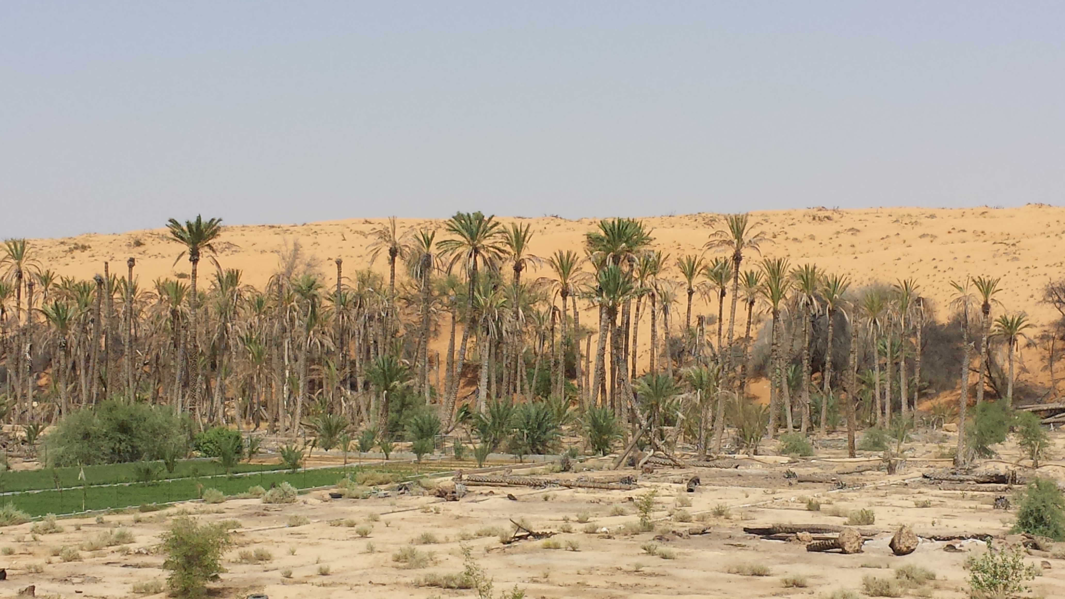
Spot images clearly show sharp changes in vegetation health through the years from 1994 to 2013. Vegetative vigour is lower in all years compared to 1994. Besides, the investigation shows a statistical relationship between rainfall and the status of the health of vegetation. Monsoon rainfall has an impact on the growth of vegetation. Around 2002-2003, the region suffered a major drought. Between 2012 and 2013, vegetative activity shows a decreasing trend. The analysis identified an area affected by the worst degree of land degradation. This area is situated in the southeastern of the Dhofar Mountains. In this area the process of land degradation is very active, with significant decrease in vegetation in 2013 compared to 2004. The mequite invasion in the Salalah Plain contributed to the degradation of natural vegetative cover in Dhofar Governorate. In nearly 30 years, the infested area almost quadrupled, indicating an average rate of expansion of 122,555m2 per year. The mesquite stands seem to have survived through the drought of 2002-2003.
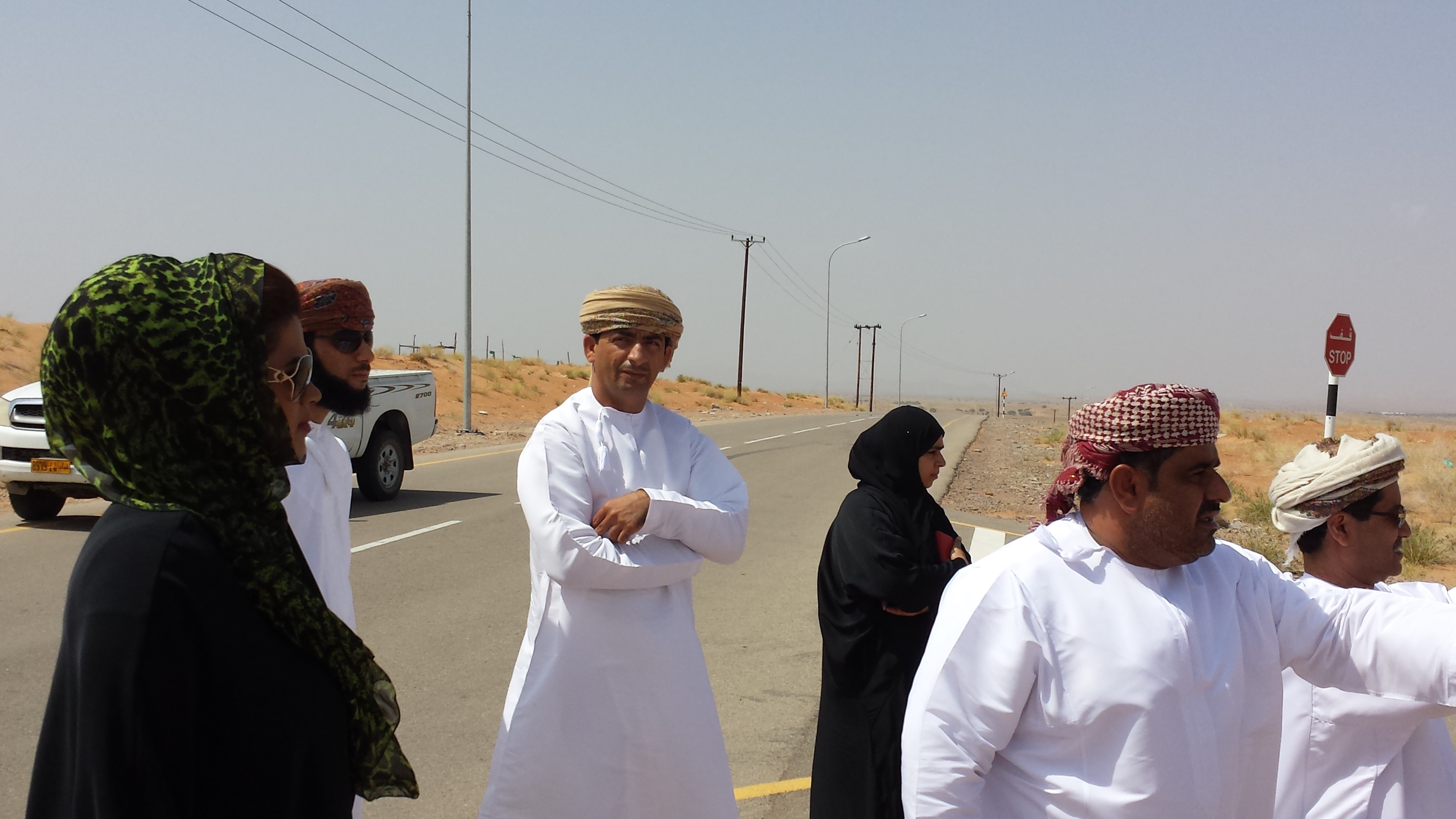
The preliminary results of the survey clearly show that the mountains of Dhofar are under heavy anthropic pressure. The number of livestock is increasing and the native plant species are in great demand for cooking and heating.
Fortunately, the analysis identifies two areas, situated in the south-west of the study area, where vegetation has increased in vigor and density. The areas preserved from this process are usually inaccessible and far from human activities.
Vegetation cover change in Al-Jabal Al-Akhdar from 1985 to 2014 was analysed using very high resolution aerial and satellite images. Vegetation cover is also studied near settlements, dams, in wadis, and in agricultural areas. The change in total vegetation cover in the study area of Al-Jabal Al-Akhdar from 1985 to 2014 is very evident from the analysis of the data and maps produced.
Vegetation cover increased from 7.38 km2 during 1985 to 13.65 km2 in 2014. This change of vegetation cover was most noticeable in wadis and gullies where vegetation increased from 4.56 km2 during to 9.38 km2. One main factor that might be contributing to this increase of vegetation in wadis is the increase in the number of dams for storing surface water, as the number of dams increased from 7 in 1985 in the study area to 27 in 2014. Vegetation within and around 1 km of settlements in the study area increased from 2.09 km2 during 1985 to 5.45 km2 in 2014. In all other areas, that are distant from human activities, there is a considerable change in green vegetation cover between 1985 and 2014 where vegetation cover increased from 2.49 km2 in 1985 to 3.91 km2 in 2014. It is important to note here that vegetation cover density has a strong correlation with the amount of rainfall in Al-Jabal Al-Akhdar and there was a large difference in the annual rainfall between the two years, i.e. 1985 and 2014. The annual rainfall in 1985 was about 150mm for that particular year. The year 1984 was not much better where annual rainfall was lower than 200mm according to available records. The annual rainfall in 2013, the year preceding date of image in 2014, was 466mm, which is three times higher that that of 1985. Given the results of this study, there is a clear indication that the amount of rainfall plays a major role in defining the density of vegetation cover even if land degradation is taking place in very localized areas where there is pressure from grazing, urbanization, and tourism.
2.3 Фотографии, иллюстрирующие Подход
Медиа-галерея

2.5 Страна/ регион/ место, где применялся Подход
Страна:
Оман
Административная единица (Район/Область):
Governorate of Dhofar, North and South Al Sharqiyah Governorates and Governorate of Al Dakhiliyah
Более точная привязка места:
Governorate of Dhofar: Taqa, Taaqa farm, Zaik, Qiroon, Marbath, Al-Haqq and Taitam Governorate of Al Dakhiliyah: Al-Jabal Al-Akhdar
2.6 Даты начала и окончания реализации Подхода
Год начала реализации:
2013
2.7 Тип Подхода
- в рамках проекта/ программы
2.8 Каковы цели/ задачи Подхода
1.Monitoring and survey of land degradation and areas vulnerable to degradation
2.Enhancing human abilities in land degradation issues
3.Identifying various degrees of degraded areas, and factors and processes causing degradation
4.Regular monitoring of degraded areas
2.9 Условия содействующие применению Технологии/ Технологий в рамках Подхода или затрудняющие его
Социальные/ культурные/ религиозные нормы и ценности
- содействуют
Cultural and religious values encourage the protection of land and planting of trees
Сотрудничество/ координация действий
- содействуют
There is always a good collaboration between the government and academic/research institutions to determine the right approaches and technologies for better management practices
Нормативно-правовая база (землевладение, права на земле- и водопользование)
- затрудняют
In some regions land tenure is not defined which affects grazing activities in these regions making it difficult to implement any replanting or reforestation projects
3. Участие и распределение ролей заинтересованных сторон
3.1 Заинтересованные стороны, участвующие в реализации Подхода и их роли
- ученые-исследователи
Researchers from Sultan Qaboos University
Approach development, analysis, and survey
- местные власти
Municipalities, Authority departments, and Governor's offices
Field visits and survey, meeting community
- государственные власти (отвечающие за планирование или принятие решений)
Environment Authority
Funding, planning approach
3.2 Участие местных землепользователей/ местных сообществ на разных стадиях реализации Подхода
| Участие местных землепользователей/ местных сообществ | Перечислите участников и опишите их вовлеченность | |
|---|---|---|
| инициирование/ мотивация | внешняя поддержка | Governor's offices in respective regions played a major role in motivating community leaders to participate in the project |
| выполнение | внешняя поддержка | Regional directorates and Governor offices helped in organizing meetings with local communities to collect information about land use activities, including farming and grazing, in their respective villages |
3.3 Схема реализации (если имеется)
3.4 Принятие решений по выбору Технологии/ Технологий УЗП
Укажите, кто принимал решение по выбору применяемой Технологии/ Технологий:
- политики/ руководители
Поясните на чём было основано принятие решений:
- результаты исследований
4. Техническая поддержка, повышение компетенций и управление знаниями
4.1 Повышение компетенций/ обучение
Проводилось ли обучение землепользователей/ других заинтересованных лиц?
Да
Укажите, кто проходил обучение:
- местный персонал/консультанты
Тип обучения:
- курсы
Рассматриваемые темы:
1.Understanding GIS and geographical approach to land degradation
2. Use of remote sensing techniques for data collection
3. Land degradation assessment in drylands
4.2 Консультационные услуги
Есть ли у землепользователей возможность получать консультации?
Нет
4.3 Институциональная (организационная) поддержка
В ходе реализации Подхода были ли организованы новые институциональные структуры или поддержаны уже существующие?
- да, умеренно
Укажите уровень, на котором структуры были укреплены или вновь созданы:
- национальный
Укажите тип поддержки:
- повышение компетенций/ обучение
4.4 Мониторинг и оценка
Являются ли мониторинг и оценка частью Подхода?
Да
Если да, будет ли данный документ использоваться для мониторинга и оценки?
Нет
4.5 Научные исследования
Были ли научные исследования частью Подхода?
Да
Укажите темы исследований:
- социология
- экология
5. Финансирование и внешняя материальная поддержка
5.1 Годовой бюджет мероприятий по УЗП в рамках Подхода
Если точный годовой бюжет неизвестен, укажите примерный диапазон затрат:
- 100 000-1 000 000
5.2 Финансирование и внешняя материальная поддержка, предоставляемая землепользователям
Предоставлялась ли землепользователям финансовая/ материальная поддержка для применения Технологии /Технологий?
Нет
5.4 Кредитование
Предоставлялись ли в рамках Подхода кредиты на мероприятия УЗП?
Нет
5.5 Другие методы или инструменты стимулирования
Использовались ли другие методы или инструменты стимулирования для продвижения Технологий УЗП?
Нет
6. Анализ влияния и заключительные положения
6.1 Влияние Подхода
Сумел ли Подход расширить возможности местных землепользователей, повысить участие заинтересованных сторон?
- Нет
- Да, немного
- Да, умеренно
- Да, существенно
Stakeholders participated in collecting social data by visiting different towns and sitting with the community to explain the approach, define the problems, and evaluate solutions
Сумел ли Подход дать возможность принимать решения на основе подтвержденных фактов?
- Нет
- Да, немного
- Да, умеренно
- Да, существенно
Solutions and practices suggested resulted from extensive field work and image analysis
Сумел ли Подход мобилизовать/ расширить доступ к финансовым ресурсам для применения практик УЗП?
- Нет
- Да, немного
- Да, умеренно
- Да, существенно
Financial resources were mobilized and directed towards plantation of trees in degraded lands
Сумел ли Подход расширить знания и возможности других заинтересованных сторон?
- Нет
- Да, немного
- Да, умеренно
- Да, существенно
Training courses were developed for government staff to collect field and social data
Сумел ли Подход укрепить сотрудничество между заинтересоваными сторонами/ выстроить механизмы сотрудничества?
- Нет
- Да, немного
- Да, умеренно
- Да, существенно
6.2 Основные причины, побуждающие землепользователей внедрять УЗП
- снижение деградации земель
- экологическая сознательность
- приобретение знаний и опыта в области УЗП
6.3 Долгосрочная устойчивость мероприятий в рамках Подхода
Могут ли землепользователи самостоятельно (без внешней поддержки) продолжать применение того, что было реализовано в рамках Подхода?
- нет уверенности
6.4 Сильные стороны/ преимущества Подхода
| Сильные стороны/ преимущества/ возможности по мнению составителя или других ключевых специалистов |
|---|
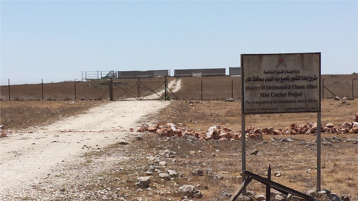
| 1-As the results show that the amount of rainfall plays a major role in defining the density of vegetation, water catchment techniques can be deployed during rainfall periods – especially during Dhofar monsoon characterized with white fog and light rains- such as fog harvesting, increasing recharge dams, using new irrigation techniques from dams for affected areas |
| 2-By mapping land degradation in the Sultanate, areas that need protective strategies and policies can be defined, to avoid the degradation of areas of similar features through the coordination with respective sectors including urban planning, tourism, and agriculture. |
| 3- As the analysis identifies areas where vegetation has increased in vigor and density, factors leading to that may be explored and studied in order to apply same factors in similar environments. |
6.5 Слабые стороны/ недостатки Подхода и пути их преодоления
| Слабые стороны/ недостатки/ риски по мнению составителя или ответственных специалистов | Возможные пути их преодоления/снижения? |
|---|---|
| 1-As the spread and type of vegetation and climatic conditions differs greatly from area to area in the Sultanate of Oman, different procedures and techniques need to be employed. | studying the general conditions and features of each area and applying different procedures and techniques based on specific characteristics. |
| 2-Analysis of vegetation change using satellite images in terrain characterized by deep slopes and deep valleys in some areas in the Sultanate is very difficult. | using very high resolution remotely sensed images |
| 3-High resolution remotely sensed images are sometimes unavailable for past periods, which hinder studying vegetation change in this region where using satellite is difficult as well. |
7. Справочные материалы и ссылки
7.1 Методы сбора/источники информации
- выезды на места, полевые обследования
- опросы землепользователей
More than 500 questionnaires
Ссылки и модули
Развернуть все Свернуть всеСсылки
Нет ссылок
Модули
Нет модулей