Level ditches in cropland [สโลวาเกีย]
- ผู้สร้างสรรค์:
- การอัพเดท:
- ผู้รวบรวม: Zuzana Studvova
- ผู้เรียบเรียง: –
- ผู้ตรวจสอบ: Fabian Ottiger, Alexandra Gavilano
Záchytné pásy na poľnohospodárskej pôde (Slovak language)
technologies_1666 - สโลวาเกีย
ดูส่วนย่อย
ขยายทั้งหมด ย่อทั้งหมด1. ข้อมูลทั่วไป
1.2 รายละเอียดที่ติดต่อได้ของผู้รวบรวมและองค์กรที่เกี่ยวข้องในการประเมินและการจัดเตรียมทำเอกสารของเทคโนโลยี
ชื่อของโครงการซึ่งอำนวยความสะดวกในการทำเอกสารหรือการประเมินเทคโนโลยี (ถ้าเกี่ยวข้อง)
Preventing and Remediating degradation of soils in Europe through Land Care (EU-RECARE )ชื่อขององค์กรซึ่งอำนวยความสะดวกในการทำเอกสารหรือการประเมินเทคโนโลยี (ถ้าเกี่ยวข้อง)
Slovak University of Technology (Slovak University of Technology) - สโลวาเกีย1.3 เงื่อนไขการใช้ข้อมูลที่ได้บันทึกผ่านทาง WOCAT
ผู้รวบรวมและวิทยากรหลักยอมรับเงื่อนไขเกี่ยวกับการใช้ข้อมูลที่ถูกบันทึกผ่านทาง WOCAT:
ใช่
1.5 Reference to Questionnaire(s) on SLM Approaches (documented using WOCAT)
The programme of landscape revitalization and integrated river … [สโลวาเกีย]
This approach is devoted to the implementation of 'The Landscape Revitalisation Programme and integrated river basins management of the Slovak Republic' in the Sobotište village.
- ผู้รวบรวม: Zuzana Studvova
2. การอธิบายลักษณะของเทคโนโลยี SLM
2.1 การอธิบายแบบสั้น ๆ ของเทคโนโลยี
คำจำกัดความของเทคโนโลยี:
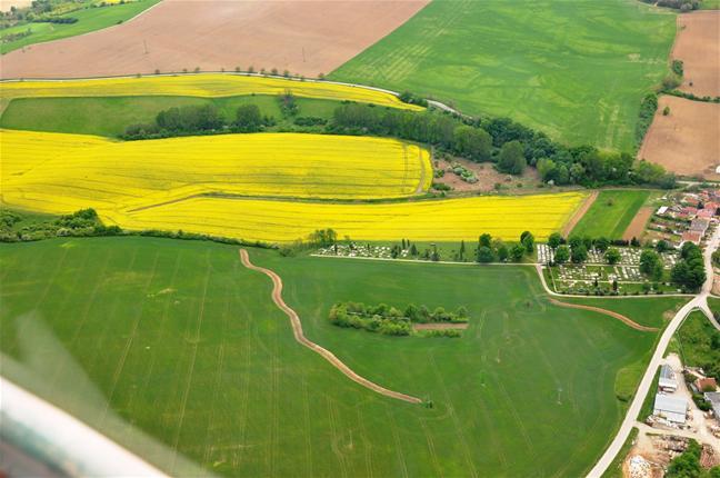
Conservation measures for eroded cropland. The technology contains level ditches of various lengths, which are digged along a contour.
2.2 การอธิบายแบบละเอียดของเทคโนโลยี
คำอธิบาย:
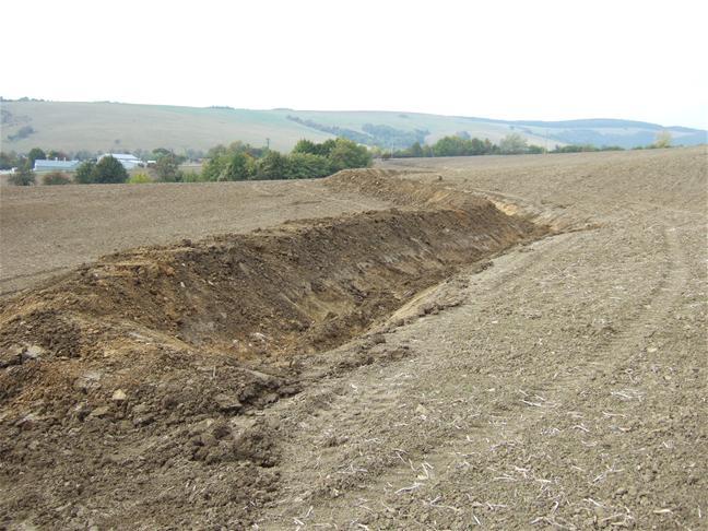
The structural measures are characterized as small technical structures to control and slow down surface runoff, created after extreme rainfall. The ditch is digged across the slope (along the contour) according to the terrain. Along the four of dithes there were also vegetative strips that should protect and retain rainfall.
Purpose of the Technology: Some damage has been observed on the farmland during storm rainfalls, long-lasting rainfalls, and periods of melting snow. The aim of the conservation measures is to eliminate hazards and damage to health and the economy, to improve the accumulation and infiltration of water into the soil, and to retard the surface runoff on the farmland.
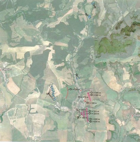
Establishment / maintenance activities and inputs: There are 7 ditches in the area (2842 m in total/ 23873 m3). In the locality of Padelky there are level ditches with lengths of 160 m + 320 m+ 830m = 1310 m; in the locality of Kubíny there are level ditches with lengths of 500 m + 100 m + 175 m = 775 m; in the locality of Šlachovec there is one ditch with the length of 750 m. The total water retention volume is 23873 m3. The ditches are in the shape of a trapezoid with a base width of 1 m, a height according to the terrain, and a slope of 1:1.5 while the digged soil is moved to the lower part of the ditch.
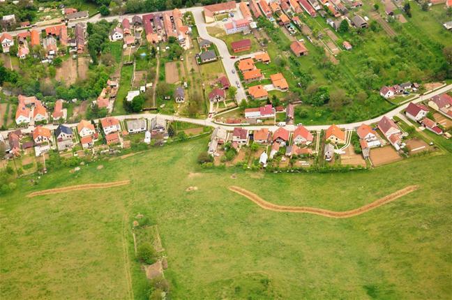
Natural / human environment: Sobotište is a village in the Teplica river basin; it is situated near the town of Senica in the Trnava region of western Slovakia. It is located in a valley at the foothills of the White Carpathians, which are part of the Carpathian Flysch Belt. The sedimentary flysh rocks are erodible, disintegrable, and sensitive to erosion.
2.3 รูปภาพของเทคโนโลยี
อัลบั้มสื่อบันทึก
2.5 ประเทศภูมิภาค หรือสถานที่ตั้งที่เทคโนโลยีได้นำไปใช้และได้รับการครอบคลุมโดยการประเมินนี้
ประเทศ:
สโลวาเกีย
ภูมิภาค/รัฐ/จังหวัด:
Slovakia
ข้อมูลจำเพาะเพิ่มเติมของสถานที่ตั้ง :
Sobotište
แสดงความคิดเห็น:
Total area covered by the SLM Technology is 12.4 km2.
Total area of the cropland cover is 12.37 km2 and the eroded area was estimated as 40 % (4.948 km2). This technology is used in the locality of Padelky and Kubina. Together 7 ditches were built. The area of the village 32.3 km2.
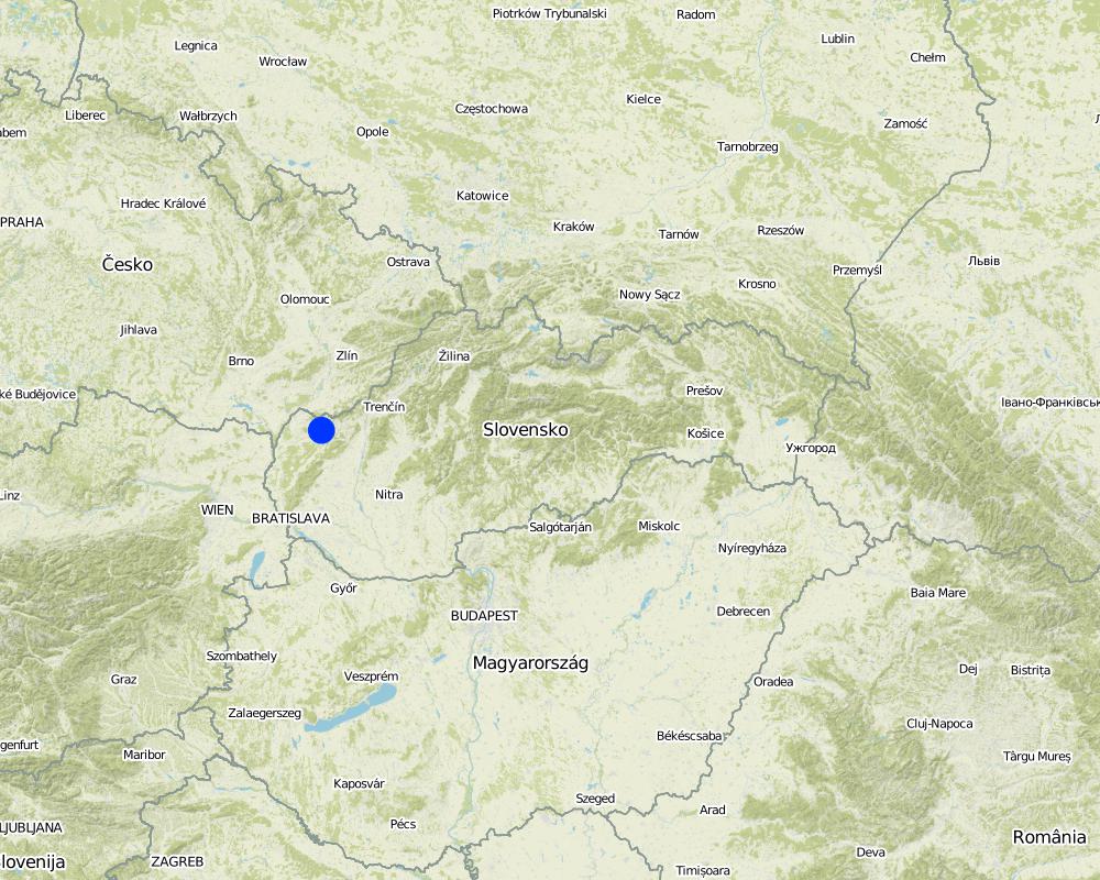
Map
×3. การจัดประเภทของเทคโนโลยี SLM
3.2 ประเภทของการใช้ที่ดินในปัจจุบันที่ได้นำเทคโนโลยีไปใช้

พื้นที่ปลูกพืช
- การปลูกพืชล้มลุกอายุปีเดียว
Annual cropping - Specify crops:
- oilseed crops - sunflower, rapeseed, other
จำนวนของฤดูเพาะปลูกต่อปี:
- 1
ระบุ:
Longest growing period in days: 180Longest growing period from month to month: April to September
แสดงความคิดเห็น:
Major land use problems (compiler’s opinion): The major problem is surface runoff that is formed by extreme rainfall whereby tillage, gully,or interrill erosion is forming.
Major land use problems (land users’ perception): There are some soil threads connected with erosion probably due to agricultural practises and heavy mechanism that are visible e.g.: people had noticed a decrease of the hills peak that is tilled. Some problems with sediments occured after heavy rains, mud flowing directly to the city (cemetery, roads etc.) from the surrounding hills and fields.
Future (final) land use (after implementation of SLM Technology): Cropland: Ca: Annual cropping
3.3 Has land use changed due to the implementation of the Technology?
Has land use changed due to the implementation of the Technology?
- Yes (Please fill out the questions below with regard to the land use before implementation of the Technology)
พื้นที่ปลูกพืช
- การปลูกพืชล้มลุกอายุปีเดียว
3.4 การใช้น้ำ
การใช้น้ำของที่ดินที่มีการใช้เทคโนโลยีอยู่:
- น้ำฝนร่วมกับการชลประทาน
3.5 กลุ่ม SLM ที่ตรงกับเทคโนโลยีนี้
- มาตรการปลูกพืชขวางความลาดชัน (cross-slope measure)
3.6 มาตรการ SLM ที่ประกอบกันเป็นเทคโนโลยี

มาตรการอนุรักษ์ด้วยวิธีพืช
- V2: หญ้าและไม้ยืนต้น

มาตรการอนุรักษ์ด้วยโครงสร้าง
- S4: คูน้ำแนวระดับ หลุม
แสดงความคิดเห็น:
Main measures: structural measures
Secondary measures: vegetative measures
Type of vegetative measures: aligned: -contour
3.7 รูปแบบหลักของการเสื่อมโทรมของที่ดินที่ได้รับการแก้ไขโดยเทคโนโลยี

การกัดกร่อนของดินโดยน้ำ
- Wt (Loss of topsoil): การสูญเสียดินชั้นบนหรือการกัดกร่อนที่ผิวดิน
- Wo (Offsite degradation): ผลกระทบนอกพื้นที่
แสดงความคิดเห็น:
Main type of degradation addressed: Wt: loss of topsoil / surface erosion
Main causes of degradation: Heavy / extreme rainfall (intensity/amounts) (Slope in connection with heavy rainfall results in surface runoff that causes erosion and mud floods in the part of the city and nearby roads), other natural causes (avalanches, volcanic eruptions, mud flows, highly susceptible natural resources, extreme topography, etc.) specify (mud flows)
Secondary causes of degradation: soil management (tillage along the slopes, deep tillage), land tenure (Land belongs to private owners and there is often a problem to get permission to use their land for other purposes, or to built conservation measures. The process of land consolidation is too long.), governance / institutional (Legislation: The financial support from the state is mainly focused on flood protection for the main rivers.)
3.8 การป้องกัน การลดลง หรือการฟื้นฟูความเสื่อมโทรมของที่ดิน
ระบุเป้าหมายของเทคโนโลยีกับความเสื่อมโทรมของที่ดิน:
- ป้องกันความเสื่อมโทรมของที่ดิน
- ลดความเสื่อมโทรมของดิน
แสดงความคิดเห็น:
Main goals: mitigation / reduction of land degradation
Secondary goals: prevention of land degradation
4. ข้อมูลจำเพาะด้านเทคนิค กิจกรรมการนำไปปฏิบัติใช้ ปัจจัยนำเข้า และค่าใช้จ่าย
4.1 แบบแปลนทางเทคนิคของเทคโนโลยี
ข้อมูลจำเพาะด้านเทคนิค (แบบแปลนทางเทคนิคของเทคโนโลยี):
There are 7 ditches in the area (2842 m in total/ 23873 m3). In the locality of Padelky there are level ditches with lengths of 160 m + 320 m+ 830m = 1310 m; in the locality of Kubíny there are level ditches with lengths of 500 m + 100 m + 175 m = 775 m; in the locality of Šlachovec there is one ditch with the length of 750 m. The total water retention volume is 23873 m3. The ditches are in the shape of a trapezoid with a base width of 1 m, a height according to the terrain, and a slope of 1:1.5 while the digged soil is moved to the lower part of the ditch.
Location: Sobotište. Myjava, Slovakia
Technical knowledge required for field staff / advisors: moderate
Technical knowledge required for land users: low
Main technical functions: control of concentrated runoff: retain / trap
Secondary technical functions: reduction of slope length, sediment retention / trapping, sediment harvesting
Aligned: -contour
Vegetative material: O : other
Number of plants per (ha): -
Vertical interval between rows / strips / blocks (m): -
Spacing between rows / strips / blocks (m): -
Vertical interval within rows / strips / blocks (m): -
Width within rows / strips / blocks (m): 40
Other species: Red clover, seeded along the ditch
Retention/infiltration ditch/pit, sediment/sand trap
Depth of ditches/pits/dams (m): 1
Width of ditches/pits/dams (m): 1
Length of ditches/pits/dams (m): various, 2842 m in total
Construction material (earth): The excavated earth is placed on the lower part and mechanically compacted to hold retained water.
Specification of dams/ pans/ ponds: Capacity 23873m3
Catchment area: 12 ham2
4.2 ข้อมูลทั่วไปเกี่ยวกับการคำนวณปัจจัยนำเข้าและค่าใช้จ่าย
อื่นๆ หรือสกุลเงินประจำชาติ (ระบุ):
Eur
If relevant, indicate exchange rate from USD to local currency (e.g. 1 USD = 79.9 Brazilian Real): 1 USD =:
0.88
4.3 กิจกรรมเพื่อการจัดตั้ง
| กิจกรรม | Timing (season) | |
|---|---|---|
| 1. | Digging of the ditch for 600 mm width | |
| 2. | Adjustment of the ditch´s embankment | |
| 3. | Digging of the ditch for 600-2000 mm width | |
| 4. | Digging of the ditch for over 2000 mm width | |
| 5. | expert guarantor and planner | |
| 6. | Transfer | |
| 7. | Vegetative strips next to the ditch in 40 m width. Red clover. | spring |
4.4 ค่าใช้จ่ายของปัจจัยนำเข้าที่จำเป็นสำหรับการจัดตั้ง
| ปัจจัยนำเข้า | หน่วย | ปริมาณ | ค่าใช้จ่ายต่อหน่วย | ค่าใช้จ่ายทั้งหมดต่อปัจจัยนำเข้า | %ของค่าใช้จ่ายที่ก่อให้เกิดขึ้นโดยผู้ใช้ที่ดิน | |
|---|---|---|---|---|---|---|
| แรงงาน | Digging of the ditch for 600 mm width | m3 | 9.9 | 18.14 | 179.59 | |
| แรงงาน | Adjustment of the ditch´s embankment | m2 | 3861.0 | 0.82 | 3166.02 | |
| แรงงาน | Digging of the ditch for 600-2000 mm width | m2 | 5253.0 | 10.24 | 53790.72 | |
| แรงงาน | or Digging of the ditch for over 2000 mm width | m2 | 5253.0 | 1.26 | 6618.78 | |
| วัสดุด้านพืช | Seeds for vegetative strips next to the ditch in 40 m width. Red clover. | kg | 704.0 | 8.15 | 5737.6 | |
| อื่น ๆ | expert guarantor and planner | person | 1.0 | 3062.61 | 3062.61 | |
| อื่น ๆ | Transfer | t | 58.655 | 46.11 | 2704.58 | |
| ค่าใช้จ่ายทั้งหมดของการจัดตั้งเทคโนโลยี | 75259.9 | |||||
| Total costs for establishment of the Technology in USD | 85522.61 | |||||
4.6 ค่าใช้จ่ายของปัจจัยนำเข้าและกิจกรรมที่เกิดขึ้นเป็นประจำที่ต้องการการบำรุงรักษา (ต่อปี)
แสดงความคิดเห็น:
Together 7 ditches were built in the study area (1240 ha of cropland). The prices and costs were available as a summary for whole project, therefore the prices correspond for all 7 ditches together. Each of the ditches were slitly different (e.g., the length). The prices are valid for the year 2011. The prices are mostly given for m3 as a unit. (The prices were calculated with the 20% VAT)
4.7 ปัจจัยสำคัญที่สุดที่มีผลกระทบต่อค่าใช้จ่าย
ปัจจัยสำคัญที่สุดที่มีผลกระทบต่อค่าใช้จ่ายต่างๆ:
The costs differ from project to project, it depends on the design, building company atc.
5. สิ่งแวดล้อมทางธรรมชาติและของมนุษย์
5.1 ภูมิอากาศ
ฝนประจำปี
- < 250 ม.ม.
- 251-500 ม.ม.
- 501-750 ม.ม.
- 751-1,000 ม.ม.
- 1,001-1,500 ม.ม.
- 1,501-2,000 ม.ม.
- 2,001-3,000 ม.ม.
- 3,001-4,000 ม.ม.
- > 4,000 ม.ม.
เขตภูมิอากาศเกษตร
- กึ่งชุ่มชื้น
Thermal climate class: temperate
5.2 สภาพภูมิประเทศ
ค่าเฉลี่ยความลาดชัน:
- ราบเรียบ (0-2%)
- ลาดที่ไม่ชัน (3-5%)
- ปานกลาง (6-10%)
- เป็นลูกคลื่น (11-15%)
- เป็นเนิน (16-30%)
- ชัน (31-60%)
- ชันมาก (>60%)
ธรณีสัณฐาน:
- ที่ราบสูง/ที่ราบ
- สันเขา
- ไหล่เขา
- ไหล่เนินเขา
- ตีนเนิน
- หุบเขา
ระดับความสูง:
- 0-100 เมตร
- 101-500 เมตร
- 501-1,000 เมตร
- 1,001-1,500 เมตร
- 1,501-2,000 เมตร
- 2,001-2,500 เมตร
- 2,501-3,000 เมตร
- 3,001-4,000 เมตร
- > 4,000 เมตร
ความคิดเห็นและข้อมูลจำเพาะเพิ่มเติมเรื่องสภาพภูมิประเทศ:
Slopes on average: Flat (59%), gentle, (23%) and moderate (9%)
5.3 ดิน
ค่าเฉลี่ยความลึกของดิน:
- ตื้นมาก (0-20 ซ.ม.)
- ตื้น (21-50 ซ.ม.)
- ลึกปานกลาง (51-80 ซ.ม.)
- ลึก (81-120 ซ.ม.)
- ลึกมาก (>120 ซ.ม.)
เนื้อดิน (ดินชั้นบน):
- หยาบ/เบา (ดินทราย)
(ถ้ามี) ให้แนบคำอธิบายเรื่องดินแบบเต็มหรือระบุข้อมูลที่มีอยู่ เช่น ชนิดของดิน ค่า pH ของดินหรือความเป็นกรดของดิน ความสามารถในการแลกเปลี่ยนประจุบวก ไนโตรเจน ความเค็ม เป็นต้น:
Soil depth on average: Moderately deep (75%), shallow (17%) and very shallow (5%)
Soil texture is coarse/light (34%), fine/heavy (12%) and medium (5%)
Soil fertiliy is medium
Top soil organic matter is unknown
Soil drainage/infiltration is good
Soil water storage capacity is unknown
5.4 ความเป็นประโยชน์และคุณภาพของน้ำ
น้ำไหลบ่าที่ผิวดิน:
เกินพอ
คุณภาพน้ำ (ที่ยังไม่ได้บำบัด):
เป็นน้ำเพื่อการดื่มที่ดี
ความคิดเห็นและข้อมูลจำเพาะเพิ่มเติมเรื่องคุณภาพและปริมาณน้ำ:
Ground water table is unknown
5.5 ความหลากหลายทางชีวภาพ
ความหลากหลายทางชนิดพันธุ์:
- ปานกลาง
5.6 ลักษณะของผู้ใช้ที่ดินที่นำเทคโนโลยีไปปฏิบัติใช้
แนวทางการตลาดของระบบการผลิต:
- mixed (subsistence/ commercial)
- ทำการค้า/การตลาด
ระดับของความมั่งคั่งโดยเปรียบเทียบ:
- พอมีพอกิน
เป็นรายบุคคล/ครัวเรือน:
- กลุ่ม/ชุมชน
ระดับของการใช้เครื่องจักรกล:
- การใช้เครื่องจักรหรือเครื่องยนต์
เพศ:
- หญิง
- ชาย
ระบุลักษณะอื่นๆที่เกี่ยวข้องของผู้ใช้ที่ดิน:
Land users applying the Technology are mainly common / average land users
Difference in the involvement of women and men: no.
Population density: 10-50 persons/km2
Annual population growth: > 4%; 16%
Off-farm income specification: unknown
5.7 Average area of land used by land users applying the Technology
- < 0.5 เฮกตาร์
- 0.5-1 เฮกตาร์
- 1-2 เฮกตาร์
- 2-5 เฮกตาร์
- 5-15 เฮกตาร์
- 15-50 เฮกตาร์
- 50-100 เฮกตาร์
- 100-500 เฮกตาร์
- 500-1,000 เฮกตาร์
- 1,000-10,000 เฮกตาร์
- >10,000 เฮกตาร์
พิจารณาว่าเป็นขนาดเล็ก กลาง หรือขนาดใหญ่ (ซึ่งอ้างอิงถึงบริบทระดับท้องถิ่น):
- ขนาดกลาง
แสดงความคิดเห็น:
There are 485 permanently occupied dwellings (2001)
5.8 กรรมสิทธิ์ในที่ดิน สิทธิในการใช้ที่ดินและสิทธิในการใช้น้ำ
กรรมสิทธิ์ในที่ดิน:
- เป็นแบบชุมชนหรือหมู่บ้าน
สิทธิในการใช้ที่ดิน:
- เกี่ยวกับชุมชน (ถูกจัดระเบียบ)
- รายบุคคล
สิทธิในการใช้น้ำ:
- เกี่ยวกับชุมชน (ถูกจัดระเบียบ)
- รายบุคคล
5.9 การเข้าถึงบริการและโครงสร้างพื้นฐาน
สุขภาพ:
- จน
- ปานกลาง
- ดี
การศึกษา:
- จน
- ปานกลาง
- ดี
ความช่วยเหลือทางด้านเทคนิค:
- จน
- ปานกลาง
- ดี
การจ้างงาน (เช่น ภายนอกฟาร์ม):
- จน
- ปานกลาง
- ดี
ตลาด:
- จน
- ปานกลาง
- ดี
พลังงาน:
- จน
- ปานกลาง
- ดี
ถนนและการขนส่ง:
- จน
- ปานกลาง
- ดี
น้ำดื่มและการสุขาภิบาล:
- จน
- ปานกลาง
- ดี
บริการด้านการเงิน:
- จน
- ปานกลาง
- ดี
6. ผลกระทบและสรุปคำบอกกล่าว
6.1 ผลกระทบในพื้นที่ดำเนินการ (On-site) จากการใช้เทคโนโลยี
ผลกระทบทางด้านเศรษฐกิจและสังคม
การผลิต
การผลิตพืชผล
ผลกระทบด้านสังคมวัฒนธรรมอื่น ๆ
Improved livelihoods and human well-being
แสดงความคิดเห็น/ระบุ:
The technology decreased risk of the mud flows that are capable of destroying homes, washing out roads, knocking down trees, and obstructing roadways.
ผลกระทบด้านนิเวศวิทยา
วัฐจักรน้ำหรือน้ำบ่า
น้ำไหลบ่าที่ผิวดิน
ดิน
สิ่งปกคลุมดิน
การสูญเสียดิน
ผลกระทบด้านนิเวศวิทยาอื่น ๆ
Risk of mud flood
Hazard towards averse events
6.2 ผลกระทบนอกพื้นที่ดำเนินการ (Off-site) จากการใช้เทคโนโลยี
ความเสียหายต่อโครงสร้างพื้นฐานของรัฐหรือของเอกชน
แสดงความคิดเห็น/ระบุ:
Reduced risk of flooding and damage of the gardens and household.
Reduced the hazards and damage of the surrounding area by heavy rainfall events.
6.3 การเผชิญและความตอบสนองของเทคโนโลยีต่อการเปลี่ยนแปลงสภาพภูมิอากาศที่ค่อยเป็นค่อยไป และสภาพรุนแรงของภูมิอากาศ / ภัยพิบัติ (ที่รับรู้ได้โดยผู้ใช้ที่ดิน)
การเปลี่ยนแปลงสภาพภูมิอากาศที่ค่อยเป็นค่อยไป
การเปลี่ยนแปลงสภาพภูมิอากาศที่ค่อยเป็นค่อยไป
| ฤดู | increase or decrease | เทคโนโลยีมีวิธีการรับมืออย่างไร | |
|---|---|---|---|
| อุณหภูมิประจำปี | เพิ่มขึ้น | ดี |
สภาพรุนแรงของภูมิอากาศ (ภัยพิบัติ)
ภัยพิบัติทางอุตุนิยมวิทยา
| เทคโนโลยีมีวิธีการรับมืออย่างไร | |
|---|---|
| พายุฝนประจำท้องถิ่น | ไม่ค่อยดี |
| พายุลมประจำท้องถิ่น | ดี |
ภัยพิบัติจากสภาพภูมิอากาศ
| เทคโนโลยีมีวิธีการรับมืออย่างไร | |
|---|---|
| ภัยจากฝนแล้ง | ดี |
ภัยพิบัติจากน้ำ
| เทคโนโลยีมีวิธีการรับมืออย่างไร | |
|---|---|
| น้ำท่วมตามปกติ (แม่น้ำ) | ไม่ค่อยดี |
ผลลัพธ์ตามมาที่เกี่ยวข้องกับภูมิอากาศอื่น ๆ
ผลลัพธ์ตามมาที่เกี่ยวข้องกับภูมิอากาศอื่น ๆ
| เทคโนโลยีมีวิธีการรับมืออย่างไร | |
|---|---|
| ช่วงการปลูกพืชที่ลดลงมา | ดี |
6.4 การวิเคราะห์ค่าใช้จ่ายและผลประโยชน์ที่ได้รับ
ผลประโยชน์ที่ได้รับเปรียบเทียบกับค่าใช้จ่ายในการจัดตั้งเป็นอย่างไร (จากมุมมองของผู้ใช้ที่ดิน)
ผลตอบแทนระยะสั้น:
ด้านบวกอย่างมาก
ผลตอบแทนระยะยาว:
ด้านบวก
ผลประโยชน์ที่ได้รับเปรียบเทียบกับค่าใช้จ่ายในการบำรุงรักษาหรือต้นทุนที่เกิดขึ้นซ้ำอีก เป็นอย่างไร (จากมุมมองของผู้ใช้ที่ดิน)
ผลตอบแทนระยะสั้น:
ด้านบวกอย่างมาก
ผลตอบแทนระยะยาว:
ด้านบวก
แสดงความคิดเห็น:
There were no maintanance required so far.
6.5 การปรับตัวของเทคโนโลยี
Of all those who have adopted the Technology, how many did so spontaneously, i.e. without receiving any material incentives/ payments?
- 0-10%
แสดงความคิดเห็น:
100% of land user families have adopted the Technology with external material support
Comments on acceptance with external material support: The implementation of the technology was founded by the state (subsidy).
Comments on adoption trend: UNknown
6.7 จุดแข็ง / ข้อได้เปรียบ / โอกาสของเทคโนโลยี
| จุดแข็ง / ข้อได้เปรียบ / โอกาสในทัศนคติของผู้ใช้ที่ดิน |
|---|
| The technology shows to be effective, however the rainfall events that have occured so far were not that extreme as before the implementation. |
| จุดแข็ง / ข้อได้เปรียบ / โอกาสในทัศนคติของผู้รวบรวมหรือวิทยากรหลัก |
|---|
| The technology is easy to realize. There is no extra knowledge required. The mechanism used to implement the technology is easy to provide. |
6.8 จุดอ่อน / ข้อเสียเปรียบ / ความเสี่ยงของเทคโนโลยีและวิธีการแก้ไข
| จุดอ่อน / ข้อเสียเปรียบ / ความเสี่ยงในทัศนคติของผู้ใช้ที่ดิน | มีวิธีการแก้ไขได้อย่างไร |
|---|---|
| The land users are satisfied with effectivness of the technology. |
| จุดอ่อน / ข้อเสียเปรียบ / ความเสี่ยงในทัศนคติของผู้รวบรวมหรือวิทยากรหลัก | มีวิธีการแก้ไขได้อย่างไร |
|---|---|
| I don´t see any disadvantage or weekness of the technology. |
7. การอ้างอิงและการเชื่อมต่อ
7.1 วิธีการและแหล่งข้อมูล
7.2 การอ้างอิงถึงสิ่งตีพิมพ์
หัวข้อ, ผู้เขียน, ปี, หมายเลข ISBN:
Project documentation, Hydrotechnológia Bratislava, s.r.o., April 2011
7.3 Links to relevant online information
URL:
http://www.obecsobotiste.sk/Vodozadrzne-opatrenia.aspx
URL:
https://www.nku.gov.sk/documents/10157/19a2305b-d9c2-43a7-8262-743650db289b
ลิงก์และโมดูล
ขยายทั้งหมด ย่อทั้งหมดลิงก์
The programme of landscape revitalization and integrated river … [สโลวาเกีย]
This approach is devoted to the implementation of 'The Landscape Revitalisation Programme and integrated river basins management of the Slovak Republic' in the Sobotište village.
- ผู้รวบรวม: Zuzana Studvova
โมดูล
ไม่มีโมดูล