Natural riparian vegetation to sustain a stable riverbank at Naro Moru River [Kenya]
- Creation:
- Update:
- Compiler: Manuel Fischer
- Editor: –
- Reviewers: David Streiff, Alexandra Gavilano
technologies_1569 - Kenya
- Full summary as PDF
- Full summary as PDF for print
- Full summary in the browser
- Full summary (unformatted)
- Natural riparian vegetation to sustain a stable riverbank at Naro Moru River: March 30, 2017 (inactive)
- Natural riparian vegetation to sustain a stable riverbank at Naro Moru River: March 30, 2017 (inactive)
- Natural riparian vegetation to sustain a stable riverbank at Naro Moru River: May 8, 2019 (public)
View sections
Expand all Collapse all1. General information
1.2 Contact details of resource persons and institutions involved in the assessment and documentation of the Technology
land user:
Ngunjiri Simon
Kenya
1.3 Conditions regarding the use of data documented through WOCAT
The compiler and key resource person(s) accept the conditions regarding the use of data documented through WOCAT:
Yes
2. Description of the SLM Technology
2.1 Short description of the Technology
Definition of the Technology:
Riverbank erosion and biodiversity decline in the riparian area can be overcome by leaving the natural vegetation undisturbed.
2.2 Detailed description of the Technology
Description:
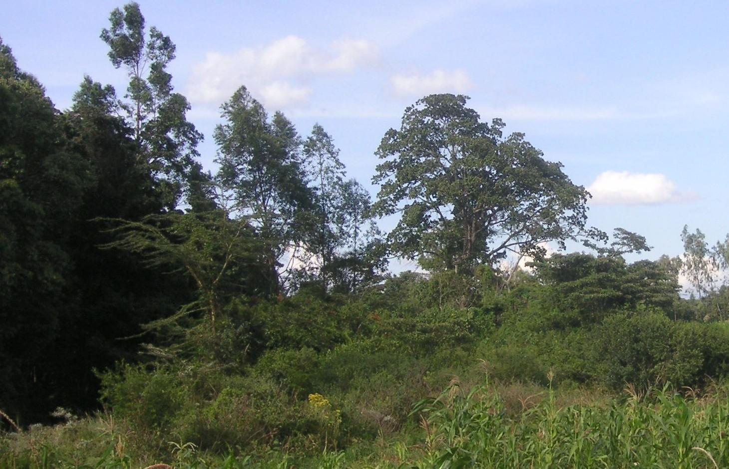
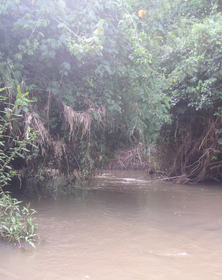
The studied land plot is situated in the semi-arid savannah zone of the Naro Moru sub-catchment at the foot of Mt. Kenya. A small-scale farmer leaves the riparian vegetation undisturbed, which enables the growth of dense bushes. On the one hand, the riparian vegetation contributes to prevent land loss caused by riverbank erosion, on the other hand it is a habitat for the special riparian fauna and flora.
Purpose of the Technology: Despite semi-arid conditions, there is a high probability of flooding. Heavy rainfalls on upper slopes of Mt. Kenya lead to flood events in the semi-arid areas of Naro Moru River. These events have a destructive effect on the riverbanks, which have become instable by human induced activities such as overgrazing and deforestation. The instable riparian soils are eroded easily. The farmers lose their precious land and the water is polluted.
Establishment / maintenance activities and inputs: A good way to overcome the riverbank degradation triggered by high runoff is a passive approach: simply leaving the riparian area undisturbed by human interference. Trees, bushes and grasses stabilize even steep riverbanks with their invading roots. As a result, almost no erosion takes place and infiltration is enhanced during rain events. The riparian microclimate, which is characterized by cooler temperatures during the day and slightly warmer temperatures during the night, is very special compared to the surrounding semi-arid zones. Also water availability is much higher than in the surroundings. Thus, this habitat offers a high biodiversity.
Natural / human environment: The plot is situated on a plateau at the western side of Mt. Kenya. There is not the same amount of precipitation as at the foot slopes of Mt. Kenya. However, the area still benefits from the runoff that is generated on the mountain. Precipitation in the so-called savannah zone ranges from 600mm to 900mm per year. Due to the high evaporation, rain-fed agriculture is only partly possible. Therefore most land users depend on irrigation using river water.
During the last decades, the region has experienced a still continuing population growth which increases population pressure in the area and removal and use of the vegetation along the rivers. The good accessibility and the moderate tourism allow even off-farm income-generation.
2.3 Photos of the Technology
Media Gallery
2.5 Country/ region/ locations where the Technology has been applied and which are covered by this assessment
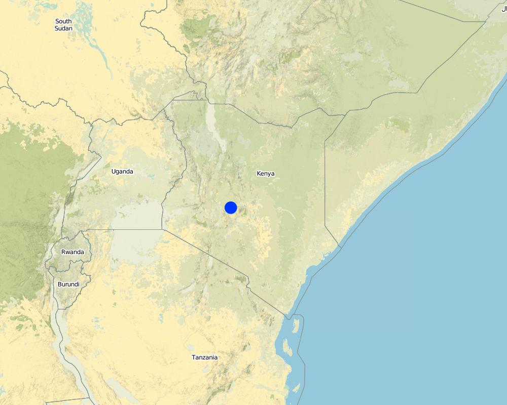
Country:
Kenya
Region/ State/ Province:
Kenya/Central Province
Further specification of location:
Naro Moru
Specify the spread of the Technology:
- evenly spread over an area
If precise area is not known, indicate approximate area covered:
- < 0.1 km2 (10 ha)
Comments:
The riparian area is very small, thus the whole plot of the farmer is indicated.
Map
×2.6 Date of implementation
If precise year is not known, indicate approximate date:
- 10-50 years ago
2.7 Introduction of the Technology
Specify how the Technology was introduced:
- through land users' innovation
Comments (type of project, etc.):
The farmer has not touched the land since 20 years.
3. Classification of the SLM Technology
3.1 Main purpose(s) of the Technology
- preserve/ improve biodiversity
- reduce risk of disasters
3.2 Current land use type(s) where the Technology is applied

Forest/ woodlands
Products and services:
- Nature conservation/ protection
- Protection against natural hazards
Comments:
Major land use problems (compiler’s opinion): In not treated areas, land users have to fight serious riverbank erosion. Due to steep riverbanks, stabilisation is very tricky.
Major land use problems (land users’ perception): Deforested riverbanks are very difficult to control, land loss is a consequence.
Other type of forest: Protected riparian forest
Problems / comments regarding forest use: The forest is left as protected forest because it stabilizes the riverbank.
Forest products and services: nature conservation / protection, protection against natural hazards
Number of growing seasons per year: 2
Longest growing period in days: 60 Longest growing period from month to month: april to may Second longest growing period in days: 60 Second longest growing period from month to month: october to november
3.5 SLM group to which the Technology belongs
- area closure (stop use, support restoration)
- surface water management (spring, river, lakes, sea)
3.6 SLM measures comprising the Technology

management measures
- M5: Control/ change of species composition
Comments:
Main measures: management measures
3.7 Main types of land degradation addressed by the Technology

soil erosion by water
- Wt: loss of topsoil/ surface erosion
- Wr: riverbank erosion

biological degradation
- Bc: reduction of vegetation cover
- Bh: loss of habitats
- Bq: quantity/ biomass decline

water degradation
- Hg: change in groundwater/aquifer level
- Hp: decline of surface water quality
- Hw: reduction of the buffering capacity of wetland areas
Comments:
Main type of degradation addressed: Wr: riverbank erosion, Hp: decline of surface water quality
Secondary types of degradation addressed: Wt: loss of topsoil / surface erosion, Bc: reduction of vegetation cover, Bh: loss of habitats, Bq: quantity / biomass decline, Hg: change in groundwater / aquifer level, Hw: reduction of the buffering capacity of wetland areas
Main causes of degradation: deforestation / removal of natural vegetation (incl. forest fires), over-exploitation of vegetation for domestic use, overgrazing, floods
Secondary causes of degradation: Heavy / extreme rainfall (intensity/amounts), population pressure, poverty / wealth
3.8 Prevention, reduction, or restoration of land degradation
Specify the goal of the Technology with regard to land degradation:
- prevent land degradation
4. Technical specifications, implementation activities, inputs, and costs
4.1 Technical drawing of the Technology
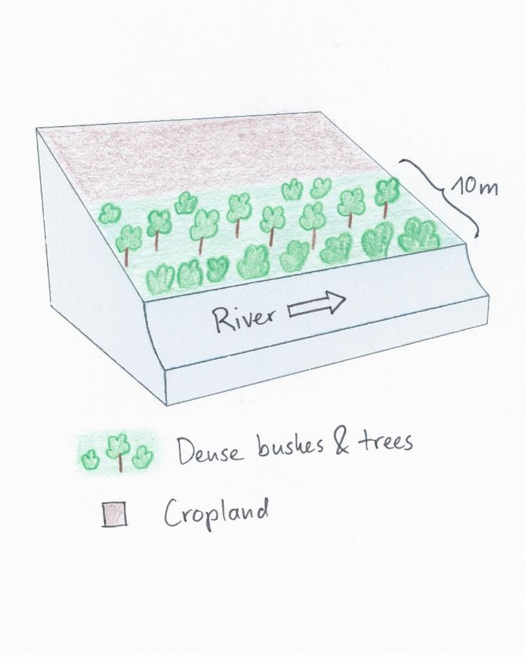
Technical specifications (related to technical drawing):
The land user noticed the riverbank erosion problems neighbours had after clearing of the riparian vegetation. This led to the protective approach of natural trees and bushes. Adjacent to the riparian area, crops are cultivated.
Location: Naro Moru. Nyeri / Central Province
Date: 28.12.2013
Technical knowledge required for field staff / advisors: low
Technical knowledge required for land users: low
Main technical functions: stabilisation of soil (eg by tree roots against land slides), increase of infiltration, improvement of water quality, buffering / filtering water, sediment retention / trapping, sediment harvesting
Secondary technical functions: improvement of ground cover, increase of surface roughness, increase / maintain water stored in soil, increase of groundwater level / recharge of groundwater
Control / change of species composition: In the protected area only indigenous tress, bushes and grasses should be present. Especially indigenous trees do not need much water and allow more water to infiltrate into the soil.
Author:
Manuel Fischer
4.2 General information regarding the calculation of inputs and costs
Specify how costs and inputs were calculated:
- per Technology unit
Specify unit:
Riparian area
Specify dimensions of unit (if relevant):
60 m
other/ national currency (specify):
Kenyan Shilling
If relevant, indicate exchange rate from USD to local currency (e.g. 1 USD = 79.9 Brazilian Real): 1 USD =:
90.0
Indicate average wage cost of hired labour per day:
2.70
4.3 Establishment activities
| Activity | Timing (season) | |
|---|---|---|
| 1. | No activities were needed |
4.5 Maintenance/ recurrent activities
| Activity | Timing/ frequency | |
|---|---|---|
| 1. | Control of species composition and destruction of invading plants | during rainy season |
4.6 Costs and inputs needed for maintenance/ recurrent activities (per year)
| Specify input | Unit | Quantity | Costs per Unit | Total costs per input | % of costs borne by land users | |
|---|---|---|---|---|---|---|
| Labour | Control of species composition and destruction of invading plants | Persons/day | 2.0 | 3.0 | 6.0 | 100.0 |
| Total costs for maintenance of the Technology | 6.0 | |||||
| Total costs for maintenance of the Technology in USD | 0.07 | |||||
5. Natural and human environment
5.1 Climate
Annual rainfall
- < 250 mm
- 251-500 mm
- 501-750 mm
- 751-1,000 mm
- 1,001-1,500 mm
- 1,501-2,000 mm
- 2,001-3,000 mm
- 3,001-4,000 mm
- > 4,000 mm
Agro-climatic zone
- semi-arid
Thermal climate class: subtropics
5.2 Topography
Slopes on average:
- flat (0-2%)
- gentle (3-5%)
- moderate (6-10%)
- rolling (11-15%)
- hilly (16-30%)
- steep (31-60%)
- very steep (>60%)
Landforms:
- plateau/plains
- ridges
- mountain slopes
- hill slopes
- footslopes
- valley floors
Altitudinal zone:
- 0-100 m a.s.l.
- 101-500 m a.s.l.
- 501-1,000 m a.s.l.
- 1,001-1,500 m a.s.l.
- 1,501-2,000 m a.s.l.
- 2,001-2,500 m a.s.l.
- 2,501-3,000 m a.s.l.
- 3,001-4,000 m a.s.l.
- > 4,000 m a.s.l.
Comments and further specifications on topography:
Altitudinal zone: 1800 m a.s.l.
5.3 Soils
Soil depth on average:
- very shallow (0-20 cm)
- shallow (21-50 cm)
- moderately deep (51-80 cm)
- deep (81-120 cm)
- very deep (> 120 cm)
Soil texture (topsoil):
- medium (loamy, silty)
Topsoil organic matter:
- medium (1-3%)
If available, attach full soil description or specify the available information, e.g. soil type, soil PH/ acidity, Cation Exchange Capacity, nitrogen, salinity etc.
Soil fertility is medium
Soil drainage / infiltration is poor - medium
Soil water storage capacity is low but with mulching it changes to medium
5.4 Water availability and quality
Ground water table:
< 5 m
Availability of surface water:
good
Water quality (untreated):
poor drinking water (treatment required)
Comments and further specifications on water quality and quantity:
Ground water table: Just along the river, deeper ground water level 50-100m
5.5 Biodiversity
Species diversity:
- medium
5.6 Characteristics of land users applying the Technology
Market orientation of production system:
- subsistence (self-supply)
Off-farm income:
- less than 10% of all income
Relative level of wealth:
- poor
Individuals or groups:
- individual/ household
Gender:
- women
- men
Indicate other relevant characteristics of the land users:
Land users applying the Technology are mainly common / average land users
Population density: 200-500 persons/km2
Off-farm income specification: The farmer has no off-farm income.
5.7 Average area of land used by land users applying the Technology
- < 0.5 ha
- 0.5-1 ha
- 1-2 ha
- 2-5 ha
- 5-15 ha
- 15-50 ha
- 50-100 ha
- 100-500 ha
- 500-1,000 ha
- 1,000-10,000 ha
- > 10,000 ha
Is this considered small-, medium- or large-scale (referring to local context)?
- small-scale
5.8 Land ownership, land use rights, and water use rights
Land ownership:
- individual, not titled
Land use rights:
- individual
Water use rights:
- open access (unorganized)
- communal (organized)
5.9 Access to services and infrastructure
health:
- poor
- moderate
- good
education:
- poor
- moderate
- good
technical assistance:
- poor
- moderate
- good
employment (e.g. off-farm):
- poor
- moderate
- good
markets:
- poor
- moderate
- good
energy:
- poor
- moderate
- good
roads and transport:
- poor
- moderate
- good
drinking water and sanitation:
- poor
- moderate
- good
financial services:
- poor
- moderate
- good
6. Impacts and concluding statements
6.1 On-site impacts the Technology has shown
Socio-economic impacts
Production
wood production
Comments/ specify:
Before the establishment of the technology, the farmer used to prune the trees. He does not do that anymore.
Socio-cultural impacts
SLM/ land degradation knowledge
aesthetics
Livelihood and human well-being
Comments/ specify:
Erosion knowledge was improved
Ecological impacts
Water cycle/ runoff
water quantity
water quality
groundwater table/ aquifer
Soil
soil moisture
soil cover
Biodiversity: vegetation, animals
plant diversity
beneficial species
habitat diversity
Climate and disaster risk reduction
drought impacts
Other ecological impacts
Riverbank erosion
6.2 Off-site impacts the Technology has shown
water availability
reliable and stable stream flows in dry season
downstream siltation
groundwater/ river pollution
buffering/ filtering capacity
6.3 Exposure and sensitivity of the Technology to gradual climate change and climate-related extremes/ disasters (as perceived by land users)
Gradual climate change
Gradual climate change
| Season | increase or decrease | How does the Technology cope with it? | |
|---|---|---|---|
| annual temperature | increase | well |
Climate-related extremes (disasters)
Meteorological disasters
| How does the Technology cope with it? | |
|---|---|
| local rainstorm | well |
| local windstorm | well |
Climatological disasters
| How does the Technology cope with it? | |
|---|---|
| drought | well |
Hydrological disasters
| How does the Technology cope with it? | |
|---|---|
| general (river) flood | well |
Other climate-related consequences
Other climate-related consequences
| How does the Technology cope with it? | |
|---|---|
| reduced growing period | well |
6.4 Cost-benefit analysis
How do the benefits compare with the establishment costs (from land users’ perspective)?
Short-term returns:
neutral/ balanced
Long-term returns:
slightly positive
How do the benefits compare with the maintenance/ recurrent costs (from land users' perspective)?
Short-term returns:
neutral/ balanced
Long-term returns:
slightly positive
Comments:
There are no establishment costs, that is why the short-term returns ares neutral. After some years, the benefits develop as long-term returns
6.5 Adoption of the Technology
- single cases/ experimental
Of all those who have adopted the Technology, how many did so spontaneously, i.e. without receiving any material incentives/ payments?
- 11-50%
Comments:
20% of land user families have adopted the Technology without any external material support
There is a little trend towards spontaneous adoption of the Technology
Comments on adoption trend: There are some farmers who are very convinced. The number of farmers adopting the technology is growing slowly.
6.7 Strengths/ advantages/ opportunities of the Technology
| Strengths/ advantages/ opportunities in the land user’s view |
|---|
|
There are no problems with riverbank erosion. How can they be sustained / enhanced? Keep the vegetation cover and do not perform too many activities in the riparian zone. |
| Strengths/ advantages/ opportunities in the compiler’s or other key resource person’s view |
|---|
|
The technology creates a habitat for the very specific riparian fauna and flora and this boosts biodiversity. How can they be sustained / enhanced? By enlarging the riparian zone. |
6.8 Weaknesses/ disadvantages/ risks of the Technology and ways of overcoming them
| Weaknesses/ disadvantages/ risks in the compiler’s or other key resource person’s view | How can they be overcome? |
|---|---|
| There is no productive use of this technology, therefore it is difficult to convince other farmers to adopt this technology. | Slight use of the riparian brings already good returns of fodder and fuelwood and still allows good protection. |
7. References and links
7.1 Methods/ sources of information
Links and modules
Expand all Collapse allLinks
No links
Modules
No modules