Fog water capture system [Ecuador]
- Creación:
- Actualización:
- Compilador: Raul Galeas
- Editor: –
- Revisores: Tatenda Lemann, Johanna Jacobi
Implementation of a fog water capture system in a conservation area in the community of Shaushi.
technologies_4050 - Ecuador
Visualizar secciones
Expandir todo Colapsar todos1. Información general
1.2 Detalles de contacto de las personas de referencia e instituciones involucradas en la evaluación y la documentación de la Tecnología
Persona(s) de referencia clave
Galeas Raul
0986027084
raul12hc@gmail.com
CONDESAN
Calle Germán Alemán E12-123 y Carlos Arroyo del Río.
Ecuador
1.3 Condiciones referidas al uso de datos documentados mediante WOCAT
¿Cuándo se compilaron los datos (en el campo)?
01/05/2017
El compilador y la/s persona(s) de referencia claves aceptan las condiciones acerca del uso de los datos documentados mediante WOCAT:
Sí
1.4 Declaración de la sostenibilidad de la Tecnología descrita
¿La Tecnología aquí descrita resulta problemática en relación a la degradación de la tierra, de tal forma que no puede considerársela una tecnología sostenible para el manejo de la tierra?
No
Comentarios:
Land management practice is intended to preserve and restore soil conditions in the area of implementation.
2. Descripción de la Tecnología MST
2.1 Breve descripción de la Tecnología
Definición de la Tecnología:
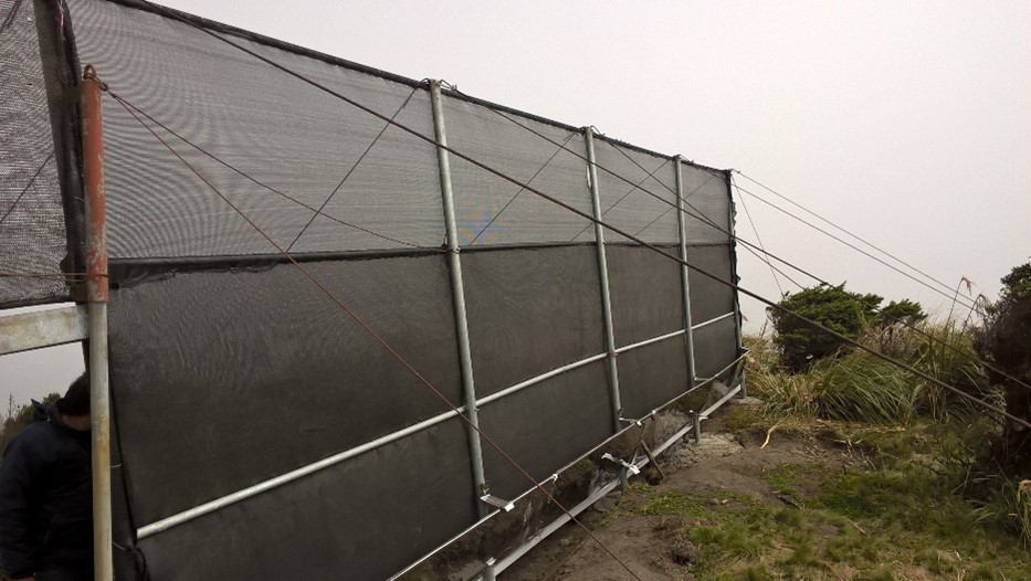
The practice consists in the installation of a water capture system, coming from the fog of the Cerro Shaushi zone, that allows to cover the need of water for domestic consumption of the inhabitants of the upper zone of the Community of Shaushi.
2.2 Descripción detallada de la Tecnología
Descripción:
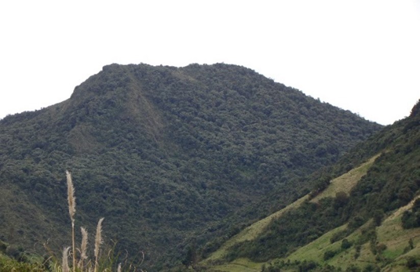
The technology was applied in the Shaushi community in La Matriz parish, Canton Quero, province of Tungurahua. It consists in the installation of fog water capture system, declaration of a conservation and protection area, and participatory monitoring of water quality and quantity. Among the purposes of the technology is to make the population aware of the sustainable use of the territory and of the environmental services it provides, and to motivate them to take an active part in the conservation and protection of natural areas and water sources. Major activities are the periodic revision of the water capture system, repair and/or replacement of deteriorated or destroyed elements, and the continuous evaluation of the functionality of the practice, and continuous monitoring of water quality and quantity. The main benefit is the availability of water for human consumption in quantity and quality, conservation of natural areas, improvement of the relationship between human beings and nature, and to have hydrometeorological information for research purposes. The users of the practice are satisfied with its implementation and the benefits perceived so far, as they have been able to demonstrate the improvements described. As an opportunity for improvement, the need to deepen the knowledge about the páramo ecosystem and its benefits within the community is established. In addition, the initiative to implement this system in other geographical points is proposed, considering its benefits and the natural conditions of the area that make possible the availability of water for the community.
2.3 Fotografías de la Tecnología
Galería de medios
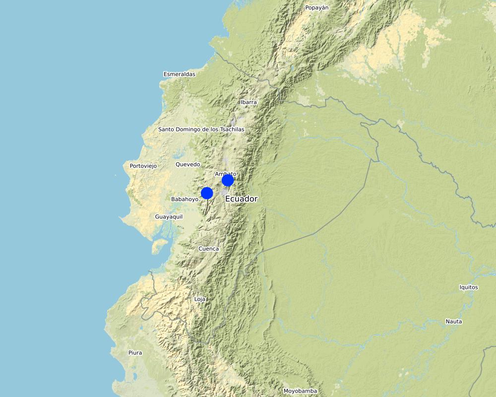
2.5 País/ región/ lugares donde la Tecnología fue aplicada y que se hallan comprendidos por esta evaluación
País:
Ecuador
Región/ Estado/ Provincia:
Tungurahua
Especifique más el lugar :
Shaushi
Comentarios:
The reserve tank stores water from the fog water capture system and from the Quintina water source for domestic consumption in the Shuashi Community, with which it can supply the beneficiary population (30 families).
Map
×2.6 Fecha de la implementación
Si no se conoce el año preciso, indique la fecha aproximada:
- hace menos de 10 años (recientemente)
2.7 Introducción de la Tecnología
Especifique cómo se introdujo la Tecnología:
- mediante la innovación de usuarios de tierras
- durante experimentos/ investigación
- mediante proyectos/ intervenciones externas
Comentarios (tipo de proyecto, etc.):
This practice was established thanks to the management carried out by the "Mancomunidda del Frente Sur Occidental", "Fondo de Páramos de Tungurahua" and "the international organization Figth Against Poverty", with the financing of cooperating entities such as "Consorcio para el Desarrollo de la Ecorregión Andina" (CONDESAN) and the Ministry of the Environment, however, it was also a decision of the community of Shaushi, who assigned the area of implementation of the practice for conservation purposes.The reserve tank stores water from the fog water capture system and from the Quintina water source for domestic consumption in the Shuashi Community, with which it can supply the beneficiary population (30 families).
3. Clasificación de la Tecnología MST
3.1 Propósito(s) principal(es) de la Tecnología MST
- reducir, prevenir, restaurar la degradación del suelo
- conservar el ecosistema
- proteger una cuenca hidrográfica/ áreas corriente abajo – en combinación con otras Tecnologías
- preservar/ mejorar biodiversidad
- crear impacto social benéfico
3.2 Tipo(s) actuales de uso de la tierra donde se aplica la Tecnología

Cultivos asociados (cultivos/ pastoreo/ árboles), incl. agroforestería
- Agropastoreo
Principales productos/ servicios:
In the area of implementation of the practice outside the conservation area alternately develops short cycle crops mainly and livestock.

Otros
Especifique:
Paramo
Comentarios:
The practice was implemented in an area that preserves its natural conditions and is in recovery. This area was declared a conservation and protection area. In the area of implementation of the practice outside the conservation area alternately develops short cycle crops mainly and livestock.
Si el uso de la tierra ha cambiado debido a la implementación de la Tecnología, indique el uso de la tierra antes de la implementación de la Tecnología.
The area where the practice was implemented was an area that was partially intervened with activities related to agriculture, grazing and forest plantations (native species and pine). Today the area is restricted under a conservation and protection agreement.
3.3 Información adicional sobre el uso de tierras
Provisión de agua para la tierra donde se aplica la Tecnología:
- mixta de secano – irrigada
Comentarios:
The area where the practice is applied does not require irrigation since it is currently under conservation agreement. The area of direct influence, outside the conservation area, in the Shaushi community uses rainwater and the Mocha - Quero Canal irrigation system as irrigation water.
Número de temporadas de cultivo por año:
- 2
Especifique:
In the cultivated area the crops (outside the conservation area) are rotated approximately after 4 to 6 months, depending on the product.
Densidad del ganado (si fuese relevante):
In the Shaushi Community, an average of 5-7 cattle per hectare is evident.
3.4 Grupo MST al que pertenece la Tecnología
- veda de zona (detener uso, apoyar la restauración)
- cosecha de agua
- protección/manejo de humedales
3.5 Difusión de la Tecnología
Especifique la difusión de la Tecnología:
- aplicada en puntos específicos/ concentrada en un área pequeña
Comentarios:
The practice of applying a water capture system, although installed in specific points, is accompanied by the declaration of the implantation zone as a conservation and protection area.
3.6 Medidas MST que componen la Tecnología

medidas estructurales
- S7: Equipo para cosechar agua / provisión de agua/ irrigación

medidas de manejo
- M1: Cambio de tipo de uso de la tierra
otras medidas
Comentarios:
Monitoring of water quality and quantity. The measures chosen correspond in the first case to the water capture system and in the second case refers to the declaration of the area of implantation of the practice as a conservation area.
3.7 Principales tipos de degradación del suelo encarados con la Tecnología

deterioro físico del suelo
- Pc: compactación

degradación biológica
- Bc: reducción de la cobertura vegetal del suelo
- Bq: reducción de la cantidad/ biomasa
- Bl: pérdida de la vida del suelo

degradación del agua
- Ha: aridificación
- Hs: cambio en la cantidad de aguas superficiales
- Hq: reducción de la calidad de subterráneas
- Hq: reducción de la calidad de aguas subterráneas
- Hw: reducción de la capacidad de amortiguación de las áreas humedales
Comentarios:
The practice avoids that in the area of conservation and sources of water they are intervened by the inhabitants of the Community of Shaushi and by the cattle of their property, with the development of sustainable activities like the capture of fog water that does not affect the availability of the resource. The water supply for domestic use for the inhabitants of Shaushi is currently provided by the Junta de Shaushi, San Vicente and Pueblo Viejo Drinking Water System. However, service coverage is partial; the inhabitants of the upper area of the Shaushi community do not have access to the water because the population has expanded over time to higher altitudes, making it impossible for the system to provide service for technical and infrastructural reasons. However, the population could not be fully supplied and there was a risk of contamination because there was no adequate infrastructure to distribute water for the two required uses.
3.8 Prevención, reducción o restauración de la degradación del suelo
Especifique la meta de la Tecnología con relación a la degradación de la tierra:
- prevenir la degradación del suelo
- reducir la degradación del suelo
Comentarios:
The practice also includes the sustainable management of soil and territory with the capture of water from the fog, the declaration of this area as an area of conservation and protection that will prevent deep soil degradation.
4. Especificaciones técnicas, actividades de implementación, insumos y costos
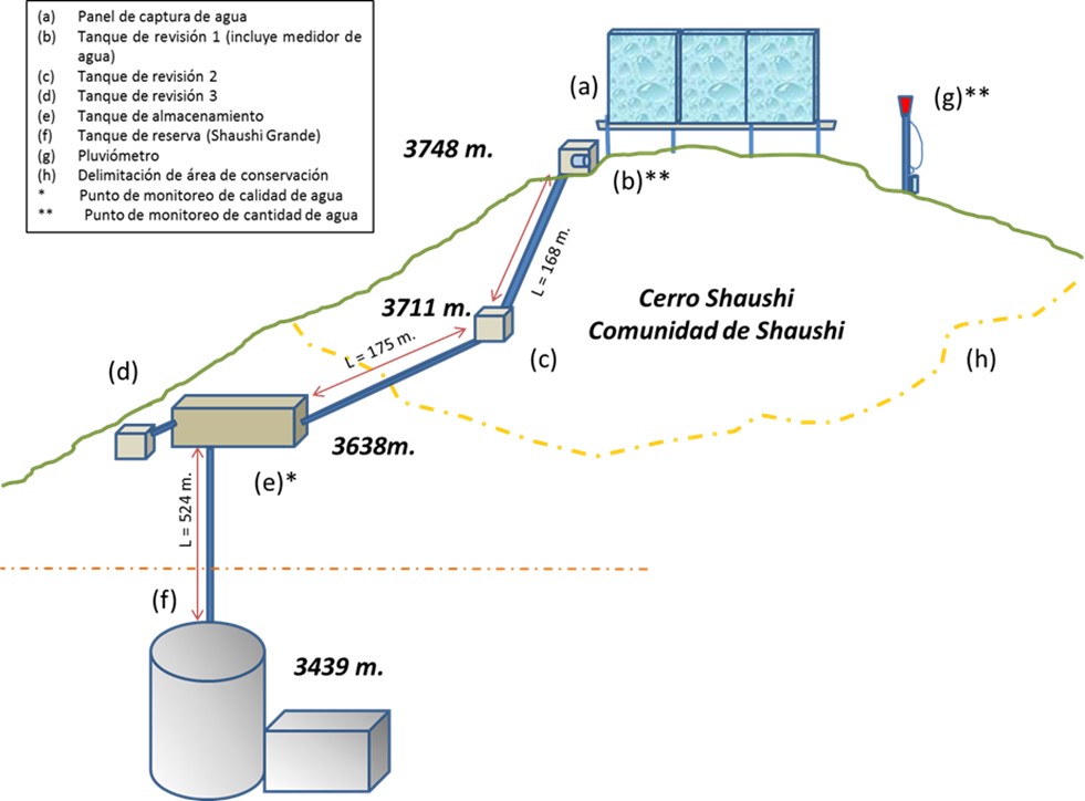
4.1 Dibujo técnico de la Tecnología
Autor:
General diagram of the practice
Fecha:
01/05/2017
4.2 Especificaciones técnicas/ explicaciones del dibujo técnico
Dimensions
Capture Panel Review and Breakthrough Tanks
Height = 4 m. length = 1.0 m.
Length = 10 m. width = 1.0 m.
depth = 1.0 m.
Driving line storage tank
Length = 343 m. length = 3 m.
Diameter = 32 mm. width = 2 m.
depth = 2 m.
Tank capacity Overhaul and breaker tanks
Volume = 1 m3
Storage tank
Volume = 12 m3
Slope angle: Mostly the terrain of the practice implantation zone is 30-40%.
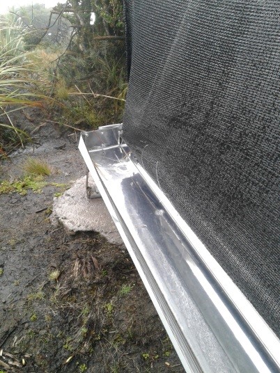
Construction material used: Galvanized steel pipes, zaran mesh, cement, stone, sand and gravel, PVC pipes, fittings (keys, elbows, valves, etc.), iron stakes for supports, tensioners, tol lids for tanks.
Area 137 ha, owned by Shaushi Community
Altitude range approx. 3400-3700 m
Slope range 30 - 40 %.
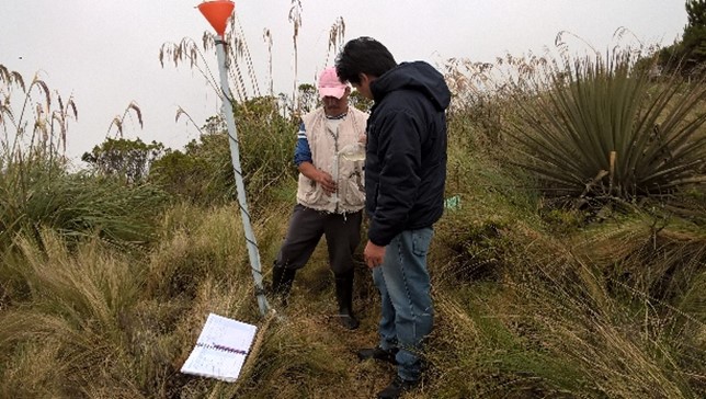
Parameters considered: pH, conductivity, total dissolved solids, water temperature, precipitation and flow.
Monitoring points water storage tank.
1) Precipitation: Nearby of the water capture screen (neblinometer).
2) Flow: to one side of the water capture panel (neblinometer).
Monthly frequency
1) Precipitation: Weekly
2) Flow: Weekly
Materials and/or equipment used
1) pH, conductivity, total dissolved solids: Multiparametric equipment.
2) Water temperature: Thermometer and/or multiparametric
equipment
1) Precipitation: Totalizer rain gauge (wooden stake, plastic bottle, mangueta, measuring probe.
2) Flow: Micrometer (water meter).
4.3 Información general sobre el cálculo de insumos y costos
Especifique cómo se calcularon los costos e insumos:
- por área de Tecnología
Especifique la moneda usada para calcular costos:
- dólares americanos
Indique el costo promedio del salario de trabajo contratado por día:
10-20
4.4 Actividades de establecimiento
| Actividad | Tipo de medida | Momento | |
|---|---|---|---|
| 1. | Installation of fog water capture system | Estructurales | Only once the site has been identified. |
| 2. | Declaration of conservation and protection area in the area of implementation of the practice | Manejo | Only once the area of interest has been identified. |
| 3. | Participatory monitoring of water quality and quantity. | Otras medidas | Amount of water: weekly Water quality: monthly |
Comentarios:
The most relevant activities carried out for the implementation of the practice are considered. In the following paragraphs the declaration activity of the conservation area will not be considered due to the fact that it is an inter-institutional management activity only.
4.5 Costos e insumos necesarios para el establecimiento
Si fuera posible, desglose los costos de establecimiento de acuerdo a la siguiente tabla, especificando insumos y costos por insumo. Si usted no pudiese desglosar los costos, proporcione un estimado de los costos totales para establecer la Tecnología:
33238,86
| Especifique insumo | Unidad | Cantidad | Costos por unidad | Costos totales por insumo | % de los costos cubiertos por los usuarios de las tierras | |
|---|---|---|---|---|---|---|
| Mano de obra | Construction and installation of the elements of the water capture system. Skilled and unskilled labor. | 1 | 1,0 | 26176,33 | 26176,33 | 3,4 |
| Mano de obra | Water quality and quantity monitoring (measurements) | 1 | 1,0 | 500,0 | 500,0 | 100,0 |
| Equipo | Miscellaneous materials for the construction and installation of the water harvesting system | 1 | 1,0 | 2012,53 | 2012,53 | |
| Equipo | Materials and equipment for water quality and quantity sampling and measurements | 1 | 1,0 | 4550,0 | 4550,0 | |
| Costos totales para establecer la Tecnología | 33238,86 | |||||
Si el usuario de la tierra no cubrió el 100% de los costos, indique quién financió el resto del costo:
The cooperating entities for the application of the practice were: CONDESAN, Ministry of Environment MAE (Project GIDACC), FMPLPT, Autonomous Decentralized Municipal Government of the canton Santiago Quero and the Commonwealth of FSO.
Comentarios:
The costs were estimated on the basis of the information available from the cooperating entities.
4.6 Actividades de establecimiento/ recurrentes
| Actividad | Tipo de medida | Momento/ frequencia | |
|---|---|---|---|
| 1. | Review of fog water capture system and additional elements for monitoring. | Otras medidas | weekly |
| 2. | Repair and/or replacement of deteriorated or damaged elements. | Estructurales | when necessary |
4.7 Costos e insumos necesarios para actividades de mantenimiento/ recurrentes (por año)
Si fuera posible, desglose los costos de mantenimiento de acuerdo a la siguiente tabla, especificando insumos y costos por insumo. Si usted no pudiese desglosar los costos, proporcione un estimado de los costos totales que se necesitan para el mantenimiento de la Tecnología:
4900,0
Si el usuario de la tierra no cubrió el 100% de los costos, indique quién financió el resto del costo:
The costs so far have been assumed by the Technical Unit of the Commonwealth of Southern Western Front.
Comentarios:
It is proposed that an agreement be made with the community to establish responsibilities for the maintenance of the practice.
4.8 Factores más determinantes que afectan los costos:
Describa los factores más determinantes que afectan los costos:
According to the perception of the beneficiaries, the most important factor that can affect the system and therefore the costs, are the environmental conditions of the area, especially the presence of strong winds that could mainly affect the water capture panel fog.
5. Entorno natural y humano
5.1 Clima
Lluvia anual
- < 250 mm
- 251-500 mm
- 501-750 mm
- 751-1,000 mm
- 1,001-1,500 mm
- 1,501-2,000 mm
- 2,001-3,000 mm
- 3,001-4,000 mm
- > 4,000 mm
Especifique el promedio anual de lluvia (si lo conoce), en mm:
615,00
Especificaciones/ comentarios sobre la cantidad de lluvia:
In the Inter-Andean region the Rainy Period presents a bimodal distribution, presenting a Secondary Rainy Period during the months of September to November and the Main Rainy Period during the months of February to May.
Indique el nombre de la estación metereológica de referencia considerada:
Querochaca and Huambalo from INAMHI
Zona agroclimática
- Sub-húmeda
The agroclimatic zone was determined based on the information of the biophysical characterization provided in the Diagnosis of the Quero Canton in the Cubillo Paulina Grade Thesis.
5.2 Topografía
Pendientes en promedio:
- plana (0-2 %)
- ligera (3-5%)
- moderada (6-10%)
- ondulada (11-15%)
- accidentada (16-30%)
- empinada (31-60%)
- muy empinada (>60%)
Formaciones telúricas:
- meseta/ planicies
- cordilleras
- laderas montañosas
- laderas de cerro
- pies de monte
- fondo del valle
Zona altitudinal:
- 0-100 m s.n.m.
- 101-500 m s.n.m.
- 501-1,000 m s.n.m
- 1,001-1,500 m s.n.m
- 1,501-2,000 m s.n.m
- 2,001-2,500 m s.n.m
- 2,501-3,000 m s.n.m
- 3,001-4,000 m s.n.m
- > 4,000 m s.n.m
Indique si la Tecnología se aplica específicamente en:
- situaciones convexas
Comentarios y especificaciones adicionales sobre topografía :
The actions carried out as part of the practice are located in an area with rugged topography, mostly in convex areas.
5.3 Suelos
Profundidad promedio del suelo:
- muy superficial (0-20 cm)
- superficial (21-50 cm)
- moderadamente profunda (51-80 cm)
- profunda (81-120 cm)
- muy profunda (>120 cm)
Textura del suelo (capa arable):
- áspera/ ligera (arenosa)
- fina/ pesada (arcilla)
Textura del suelo (> 20 cm debajo de la superficie):
- áspera/ ligera (arenosa)
- fina/ pesada (arcilla)
Materia orgánica de capa arable:
- elevada (>3%)
Si se halla disponible, adjunte una descripción completa de los suelos o especifique la información disponible, por ej., tipo de suelo, pH/ acidez de suelo, capacidad de intercambio catiónico, nitrógeno, salinidad, etc. :
The soils of Quero are volcanic and are mainly differentiated by the parental material: there are soils formed in recent volcanic ash (Andosoles: northern and central soils) and soils formed in meteorized metamorphic rock (Inceptisoles: southern soils).
Specifically they are evidenced from Udic Eutrandepts soils (Hv) and their characteristics are: isothermal black; francs with fine to medium sand with clear presence of silt; 4 to 5% organic matter from 0 to 20 cm; deep (1m); friable; well drained; water retention from 10 to 20%; neutral pH; medium natural fertility.
In this area, also have an Entic Distrandepts soils (Dny) and their characteristics are: with content of coarse pumice sand in more than 35% over the whole profile. Moderate to high water retention capacity, 50 to 80%; very black; loamy pseudo-silt textures; deep; well drained.
5.4 Disponibilidad y calidad de agua
Agua subterránea:
en superficie
Disponibilidad de aguas superficiales:
mediana
Calidad de agua (sin tratar):
agua potable de mala calidad (requiere tratamiento)
¿La salinidad del agua es un problema?
No
¿Se está llevando a cabo la inundación del área? :
No
Comentarios y especificaciones adicionales sobre calidad y cantidad de agua:
The monitoring of the captured water is currently being carried out, with the result that up to now the water is of acceptable quality. There is no specific groundwater information available for the area. It is estimated that the soil is not very permeable and the aquifers are very localized (INAMHI, 2015).
5.5 Biodiversidad
Diversidad de especies:
- mediana
Diversidad de hábitats:
- mediana
Comentarios y especificaciones adicionales sobre biodiversidad:
In order to determine the diversity of the practice area, the following data are considered: The Sierra del Ecuador region is characterized for being crossed by knots and high mountain chains (with their moors), which have their own biodiversity and diversity of environments and habitats, due to isolation. The ecosystem maintains shrub and herbaceous vegetation (Mena and Medina, 2001). The moor in Quero canton has an evident fragility, due to the constant expansion of the agricultural frontier, overgrazing, burning of grasslands, deforestation, etc., so that the area destined for conservation and protection in the Community of Shaushi is only a remnant of this ecosystem (GAD Quero, 2014).
5.6 Las características de los usuarios de la tierra que aplican la Tecnología
Sedentario o nómada:
- Sedentario
Orientación del mercado del sistema de producción:
- mixta (subsistencia/ comercial)
Ingresos no agrarios:
- menos del 10% de todos los ingresos
Individuos o grupos:
- individual/ doméstico
- grupos/ comunal
Nivel de mecanización:
- trabajo manual
- mecanizado/motorizado
Género:
- mujeres
- hombres
Edad de los usuarios de la tierra:
- personas de mediana edad
Indique otras características relevantes de los usuarios de las tierras:
In order to determine the relative level of poverty, data are taken from the 2010 National Census conducted by INEC, which indicates that the percentage of poor due to unsatisfied basic needs in Quero canton is 84.5% (GAD Quero, 2014; SNI, 2017). The components or dimensions: (i) quality of housing, (ii) overcrowding, (iii) access to basic services, (iv) access to education and (v) economic capacity (INEC, 2016).
5.7 Área promedio de la tierra que pertenece a o es arrendada por usuarios de tierra que aplican la Tecnología
- < 0.5 ha
- 0.5-1 ha
- 1-2 ha
- 2-5 ha
- 5-15 ha
- 15-50 ha
- 50-100 ha
- 100-500 ha
- 500-1,000 ha
- 1,000-10,000 ha
- > 10,000 ha
¿Esto se considera de pequeña, mediana o gran escala (refiriéndose al contexto local)?
- pequeña escala
Comentarios:
The inhabitants of the Shaushi Community have an average area of less than 3 ha.
5.8 Tenencia de tierra, uso de tierra y derechos de uso de agua
- mixed
- mixed
Derechos de uso de agua:
- comunitarios (organizado)
Comentarios:
In the area of direct influence (Shaushi Community) the lands are individual property except for the area destined for conservation and protection which is communal.
5.9 Acceso a servicios e infraestructura
salud:
- pobre
- moderado
- bueno
educación:
- pobre
- moderado
- bueno
asistencia técnica:
- pobre
- moderado
- bueno
empleo (ej. fuera de la granja):
- pobre
- moderado
- bueno
mercados:
- pobre
- moderado
- bueno
energía:
- pobre
- moderado
- bueno
caminos y transporte:
- pobre
- moderado
- bueno
agua potable y saneamiento:
- pobre
- moderado
- bueno
servicios financieros:
- pobre
- moderado
- bueno
6. Impactos y comentarios para concluir
6.1 Impactos in situ demostrados por la Tecnología
Impactos socioeconómicos
Disponibilidad y calidad de agua
disponibilidad de agua potable
calidad de agua potable
Impactos socioculturales
situación de salud
derechos de uso de la tierra/ agua
instituciones comunitarias
MST/ conocimiento de la degradación del suelo
mitigación de conflicto
Impactos ecológicos
Ciclo de agua/ escurrimiento de sedimento
cantidad de agua
calidad de agua
cosecha/ recolección de agua
Suelo
humedad del suelo
cubierta del suelo
compactación de suelo
Biodiversidad: vegetación, animales
Cubierta vegetal
diversidad vegetal
Reducción de riesgos de desastres y riesgos climáticos
impactos de sequías
emisión de carbono y gases de invernadero
micro-clima
6.2 Impactos fuera del sitio demostrados por la Tecnología
disponibilidad de agua
corriente confiable y estable fluye en estación seca
Comentarios acerca de la evaluación del impacto:
Impacts that have been classified as insignificant are thus valued because they are impacts expected by the practices considering their scope, but which have not been measured or perceived by the population as opposed to the impacts valued at the time of analysis.
6.3 Exposición y sensibilidad de la Tecnología al cambio climático gradual y a extremos relacionados al clima/ desastres (desde la percepción de los usuarios de tierras)
Cambio climático gradual
Cambio climático gradual
| Estación | tipo de cambios climáticos/ climas extremos | ¿Cómo es que la tecnología soporta esto? | |
|---|---|---|---|
| temperatura anual | incrementó | no se sabe | |
| lluvia anual | incrementó | bien | |
| Otro cambio climático gradual | Loss of seasonality | incrementó | no se sabe |
Extremos (desastres) relacionados al clima
Desastres climatológicos
| ¿Cómo es que la tecnología soporta esto? | |
|---|---|
| ola de frío | bien |
6.4 Análisis costo-beneficio
¿Cómo se comparan los beneficios con los costos de establecimiento (desde la perspectiva de los usuarios de tierra)?
Ingresos a corto plazo:
muy positivo
Ingresos a largo plazo:
muy positivo
¿Cómo se comparan los beneficios con los costos de mantenimiento/ recurrentes (desde la perspectiva de los usuarios de tierra)?
Ingresos a corto plazo:
muy positivo
Ingresos a largo plazo:
muy positivo
Comentarios:
The most plausible benefit for the population of the Shaushi Community is the availability of water for human consumption for the inhabitants who did not have it, so the comparison in terms of costs is assumed in the case of not having the practice, which would represent carrying out a project to transport the water from another geographical point, which would be more costly. On the other hand, the perceived benefits also include environmental and health benefits, which are not quantified economically, thanks to the conservation of the area of implantation of the practice.
6.5 Adopción de la Tecnología
- más de 50%
Si tiene la información disponible, cuantifique (número de hogares y/o área cubierta):
23
De todos quienes adoptaron la Tecnología, ¿cuántos lo hicieron espontáneamente, es decir, sin recibir incentivos/ pagos materiales?
- 90-100%
Comentarios:
The decision to adopt the practice was made within the Shaushi Community (beneficiaries) for those who did not have the service, where the villagers understood the need to allocate the area for conservation and protection considering the benefits it provides, and the advantage of having a system that would provide water for the consumption of the villagers who did not have the resource.
6.6 Adaptación
¿La tecnología fue modificada recientemente para adaptarse a las condiciones cambiantes?
Sí
otros (especifique):
Climatic conditions, terrain and structure of the water capture panel.
Especifique la adaptación de la Tecnología (diseño, material/ especies, etc.):
The dimensions of the excavations were reviewed to place the holders and turnbuckles, considering the slope and shape of the relief so that the system is stable.
6.7 Fuerzas/ ventajas/ oportunidades de la Tecnología
| Fuerzas/ ventajas/ oportunidades desde la perspectiva del usuario de la tierra |
|---|
| The commitment of the inhabitants of the community to preserve the environment and specifically the protection area that provides them with water in quantity and quality. |
| The water capture system provides them with direct benefits in terms of the availability of drinking water for this zone. |
| Participatory monitoring is beneficial because it allows them to control the quality and quantity of water that the system can provide. |
| Fuerzas/ ventajas/ oportunidades desde la perspectiva del compilador o de otra persona de referencia clave |
|---|
| Plant restoration trials can be carried out to improve knowledge in these ecosystems, which were intervened and which are subsequently destined for conservation. |
| It is possible to investigate how a natural ecosystem in conservation interacts with the areas in its surroundings that are highly intervened and how it could affect it. |
| Decrease in dependence on other water sources for sustainable management of soil and other resources. |
| Investigations can be carried out based on the measurements and analysis of water quantity and quality carried out and to be carried out. Analysis of soil moisture and other elements may be included. |
| Implementation of other practices for research and/or sustainable use of soil and water, with high community participation. |
| The community can be strengthened with respect to issues related to the conservation of these ecosystems and the services they provide, so that they can be properly managed and managed. |
6.8 Debilidades/ desventajas/ riesgos de la Tecnología y formas de sobreponerse a ellos
| Debilidades/ desventajas/ riesgos desde la perspectiva del usuario de la tierra | ¿Cómo sobreponerse a ellas? |
|---|---|
| Some users do not respect the rules established for the management of the area destined for conservation, and residues from past activities are still observed. | Sanctions can be established for the presence of any improper action, however, in parallel with the practice, training should continue to involve users more in the review and maintenance activities, in order to achieve a better result. |
| The environmental conditions of the site, especially the strength of the wind in the area. | It is being continuously reviewed to detect any impact on the system, especially on the water capture panel, which could break or become dislocated. |
| In the water capture panel fog, due to the height of the water collection gutter, it splashes in heavy rain events allowing soil to enter into the system from the ground. The same factor when the system becomes saturated or plugged the water overflows into the gutter, so collection is sometimes inefficient. | The functionality of the system is being reviewed, if necessary any modifications will be made in coordination with the community. |
| Debilidades/ desventajas/ riesgos desde la perspectiva del compilador o de otra persona de referencia clave | ¿Cómo sobreponerse a ellas? |
|---|---|
| Lack of a preventive and corrective maintenance plan to maintain optimal conditions. | It is neccesary to include a preventive and corrective maintenance plan that should be agreed between the technical area of the cooperating entities and with the users of the communities for its application. |
| The practice of permanent monitoring is insufficient, because data collection is minimal. | The cooperating entities and community authorities can establish a monitoring action plan that covers several lines, including infrastructure such as monitoring for research purposes. |
7. Referencias y vínculos
7.1 Métodos/ fuentes de información
- visitas de campo, encuestas de campo
Se entrevistaron a usuarios de la Tierra y técnicos de las entidades cooperantes.
- entrevistas con usuarios de tierras
3 usuarios de la tierra, uno de ellos es el Presidente de la Junta de Agua Potable.
- entrevistas con especialistas/ expertos en MST
Tres técnicos de las entidades cooperantes: Mancomunidad FSO y Fondo de Páramos
- compilación de informes y otra documentación existente
Los documentos utilizados comprenden los informes técnicos elaborados por los técnicos del Fondo de Páramos, informes y términos de referencia elaborados por la Unidad Técnica de la Mancomunidad de FSO.
7.2 Vínculos a las publicaciones disponibles
Título, autor, año, ISBN:
"Los páramos del Ecuador". Mena Vásconez Patricio y Medina Galo. 2001. Abya-Yala / Proyecto Páramo, Quito.
¿Dónde se halla disponible? ¿Costo?
Available for free online: https://www.portalces.org/sites/default/files/references/044_Mena%20et%20al.%20(Eds.).%20%202001.Paramos%20Ecuador%20PORTADA%2B_%2BHOJA%2BTECNICA%2BY%2BPRESENTACION.pdf
Título, autor, año, ISBN:
"La biodiversidad en el Ecuador". Bravo Velásquez Elizabeth. 2014. Universidad Politécnica Salesiana. Cuenca-Ecuador.
¿Dónde se halla disponible? ¿Costo?
Available for free online: https://dspace.ups.edu.ec/handle/123456789/6788
Título, autor, año, ISBN:
Actualización Plan de Desarrollo y Ordenamiento Territorial-Quero 2014. Gobierno Autónomo Descentralizado Municipal del Cantón Quero. 2014.
¿Dónde se halla disponible? ¿Costo?
Available for free online: http://app.sni.gob.ec/sni-link/sni/PORTAL_SNI/data_sigad_plus/sigadplusdiagnostico/1860000800001_PDYOT%20QUERO%20CONSOLIDADO_19-04-2015_20-19-44.pdf
Título, autor, año, ISBN:
Informe de implementación de un sistema de captura de agua niebla en la comunidad de Shaushi, en el cantón Quero. Guevara Rocío. 2017. Fondo de Manejo de Páramos y Lucha contra la pobreza Tungurahua.
¿Dónde se halla disponible? ¿Costo?
In the archives of the Tungurahua Wetland Fund and Fight against Poverty in the GAD of the province of Tungurahua.
Título, autor, año, ISBN:
Informe y base de datos de Shaushi y Llimpes, que incluye la línea base llena y estructurada de acuerdo a los lineamientos de CONDESAN. Calle Juan. 2017. CONDESAN.
¿Dónde se halla disponible? ¿Costo?
In the archives of the Consortium for Sustainable Development of the Andean Ecoregion CONDESAN.
Título, autor, año, ISBN:
Informe final de “Construcción de un sistema de captura de agua niebla en la comunidad de Shaushi, cantón Quero”. Mancomunidad de GADs municipales “Frente Sur Occidental” de la provincia de Tungurahua. 2017.
¿Dónde se halla disponible? ¿Costo?
In the archives of the Technical Unit of the Mancomunidad de GADs municipales "Frente Sur Occidental" of the province of Tungurahua.
Título, autor, año, ISBN:
Manual de monitoreo hídrico participativo. Calles Juan. 2016. CONDESAN.
¿Dónde se halla disponible? ¿Costo?
In the archives of the Consortium for Sustainable Development of the Andean Ecoregion CONDESAN.
Título, autor, año, ISBN:
Reporte de Pobreza y Desigualdad. Diciembre 2016. INEC. Dirección responsable de la información estadística y contenidos: Dirección de Innovación en Métricas y Metodologías.
¿Dónde se halla disponible? ¿Costo?
Available for free online: https://www.ecuadorencifras.gob.ec/documentos/web-inec/POBREZA/2016/Diciembre_2016/Reporte%20pobreza%20y%20desigualdad-dic16.pdf
Título, autor, año, ISBN:
Ubicación del Nuevo Relleno Sanitario en base a criterios ambientales, socioeconómicos y técnicos, y propuesta de Plan de Reciclaje en la ciudad de Quero, Cantón Quero Provincia del Tungurahua. Cubillo Paulina. 2005. Escuela Politécnica del Ejército.
¿Dónde se halla disponible? ¿Costo?
Available for free online: http://repositorio.espe.edu.ec/xmlui/handle/21000/722
Título, autor, año, ISBN:
Introducción a la Hidrogeología del Ecuador (Segunda Versión). Burbano Napoléon, Becerra Simón, Pasquel Efrén. 2014. INAMHI
¿Dónde se halla disponible? ¿Costo?
Available for free online: http://www.serviciometeorologico.gob.ec/Publicaciones/Hidrologia/HIDROGEOLOGIA_2%20EDICION_2014.pdf
7.3 Vínculos a la información relevante disponible en línea
Título/ descripción:
Anuarios meteorológicos del Instituto Nacional de Meteorología e Hidrología INAMHI.
URL:
http://www.forosecuador.ec/forum/ecuador/educaci%C3%B3n-y-ciencia/35393-inamhi-anuarios-metereol%C3%B3gicos-en-pdf
Título/ descripción:
Boletín Anual del Instituto Nacional de Meteorología e Hidrología INAMHI.
URL:
http://www.serviciometeorologico.gob.ec/boletin-anual/
Título/ descripción:
Indicadores de pobreza del INEC 2010. Sistema Nacional de Información.
URL:
http://indestadistica.sni.gob.ec/QvAJAXZfc/opendoc.htm?document=SNI.qvw&host=QVS@kukuri&anonymous=truehttp://indestadistica.sni.gob.ec/QvAJAXZfc/opendoc.htm?document=SNI.qvw&host=QVS@kukuri&anonymous=true&bookmark=Document/BM27
Título/ descripción:
Sistema Nacional de Información. Página de la Secretaría Nacional de Planificación y Desarrollo del Ecuador
URL:
http://app.sni.gob.ec/web/menu/
Vínculos y módulos
Expandir todo Colapsar todosVínculos
No hay vínculos
Módulos
No se hallaron módulos