Implementation of a fog water capture system in a conservation area in the community of Shaushi. [ប្រទេសអេក្វាទ័រ]
- ការបង្កើត៖
- បច្ចុប្បន្នភាព
- អ្នកចងក្រង៖ Raul Galeas
- អ្នកកែសម្រួល៖ –
- អ្នកត្រួតពិនិត្យច្រើនទៀត៖ Tatenda Lemann, Johanna Jacobi
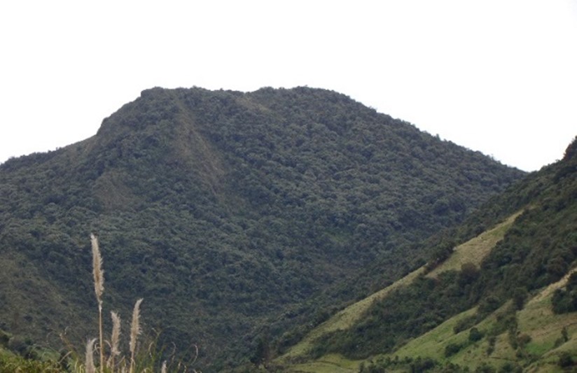
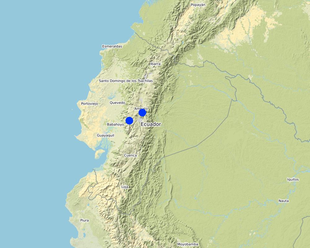
Shaushi Community, La Matriz Parish, Canton Quero, Province of Tungurahua.
technologies_4050 - ប្រទេសអេក្វាទ័រ
ពិនិត្យមើលគ្រប់ផ្នែក
ពង្រីកមើលទាំងអស់ បង្រួមទាំងអស់1. ព័ត៌មានទូទៅ
1.2 ព័ត៌មានលម្អិតពីបុគ្គលសំខាន់ៗ និងស្ថាប័នដែលចូលរួមក្នុងការវាយតម្លៃ និងចងក្រងឯកសារនៃបច្ចេកទេស
បុគ្គលសំខាន់ម្នាក់ (ច្រើននាក់)
Galeas Raul
0986027084
raul12hc@gmail.com
CONDESAN
Calle Germán Alemán E12-123 y Carlos Arroyo del Río.
ប្រទេសអេក្វាទ័រ
1.3 លក្ខខណ្ឌទាក់ទងទៅនឹងការប្រើប្រាស់ទិន្នន័យដែលបានចងក្រងតាមរយៈ វ៉ូខេត
តើពេលណាដែលទិន្នន័យបានចងក្រង (នៅទីវាល)?
01/05/2017
អ្នកចងក្រង និង(បុគ្គលសំខាន់ៗ)យល់ព្រមទទួលយកនូវលក្ខខណ្ឌនានាទាក់ទងទៅនឹងការប្រើប្រាស់ទិន្នន័យដែលបានចងក្រងតាមរយៈវ៉ូខេត:
បាទ/ចា៎
1.4 សេចក្តីប្រកាសស្តីពីចីរភាពនៃការពណ៌នាពីបច្ចេកទេស
តើបច្ចេកទេសដែលបានពណ៌នានេះមានបញ្ហាដែលផ្តោតលើការធ្លាក់ចុះគុណភាពដី, បើដូច្នេះវាមិនអាចត្រូវបានប្រកាសថាជាបច្ចេកទេសនៃការគ្រប់គ្រងប្រកបដោយចីរភាពទេ?
ទេ
មតិយោបល់:
Land management practice is intended to preserve and restore soil conditions in the area of implementation.
2. ការពណ៌នាពីបច្ចេកទេស SLM
2.1 ការពណ៌នាដោយសង្ខេបពីបច្ចេកទេស
និយមន័យបច្ចេកទេស:
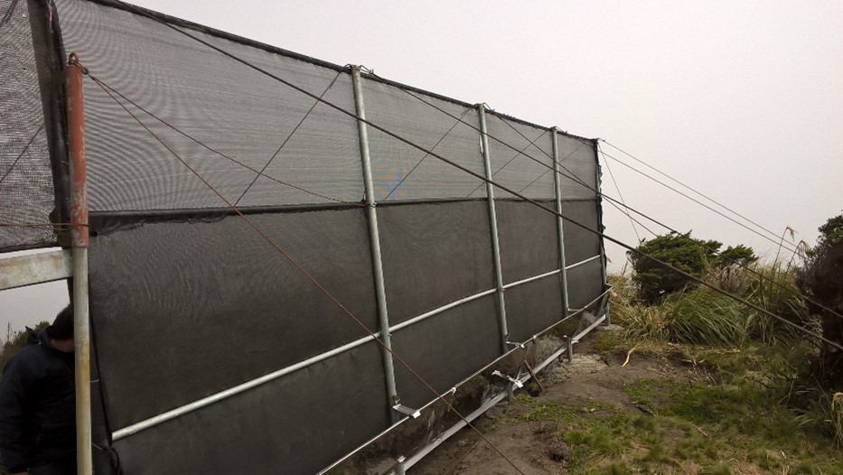
The practice consists in the installation of a water capture system, coming from the fog of the Cerro Shaushi zone, that allows to cover the need of water for domestic consumption of the inhabitants of the upper zone of the Community of Shaushi.
2.2 ការពណ៌នាលម្អិតពីបច្ចេកទេស
ការពណ៌នា:
The technology was applied in the Shaushi community in La Matriz parish, Canton Quero, province of Tungurahua. It consists in the installation of fog water capture system, declaration of a conservation and protection area, and participatory monitoring of water quality and quantity. Among the purposes of the technology is to make the population aware of the sustainable use of the territory and of the environmental services it provides, and to motivate them to take an active part in the conservation and protection of natural areas and water sources. Major activities are the periodic revision of the water capture system, repair and/or replacement of deteriorated or destroyed elements, and the continuous evaluation of the functionality of the practice, and continuous monitoring of water quality and quantity. The main benefit is the availability of water for human consumption in quantity and quality, conservation of natural areas, improvement of the relationship between human beings and nature, and to have hydrometeorological information for research purposes. The users of the practice are satisfied with its implementation and the benefits perceived so far, as they have been able to demonstrate the improvements described. As an opportunity for improvement, the need to deepen the knowledge about the páramo ecosystem and its benefits within the community is established. In addition, the initiative to implement this system in other geographical points is proposed, considering its benefits and the natural conditions of the area that make possible the availability of water for the community.
2.3 រូបភាពនៃបច្ចេកទេស
វិចិត្រសាលប្រព័ន្ធផ្សព្វផ្សាយ
2.5 ប្រទេស/តំបន់/ទីតាំងកន្លែង ដែលបច្ចេកទេសត្រូវបានអនុវត្ត និងបានគ្រប់ដណ្តប់ដោយការវាយតម្លៃនេះ
ប្រទេស:
ប្រទេសអេក្វាទ័រ
តំបន់/រដ្ឋ/ខេត្ត:
Tungurahua
បញ្ជាក់បន្ថែមពីលក្ខណៈនៃទីតាំង:
Shaushi
មតិយោបល់:
The reserve tank stores water from the fog water capture system and from the Quintina water source for domestic consumption in the Shuashi Community, with which it can supply the beneficiary population (30 families).
Map
×2.6 កាលបរិច្ឆេទនៃការអនុវត្ត
ប្រសិនបើមិនច្បាស់ឆ្នាំ សូមបញ្ជាក់កាលបរិច្ឆេទដែលប្រហាក់ប្រហែល:
- តិចជាង 10ឆ្នាំមុន (ថ្មី)
2.7 ការណែនាំពីបច្ចេកទេស
សូមបញ្ជាក់តើបច្ចេកទេសត្រូវបានណែនាំឱ្យអនុវត្តដោយរបៀបណា:
- តាមរយៈការបង្កើតថ្មីរបស់អ្នកប្រើប្រាស់ដី
- ពេលកំពុងពិសោធន៍
- តាមរយៈគម្រោង / អន្តរាគមន៍ពីខាងក្រៅ
មតិយោបល់ (ប្រភេទនៃគម្រោង ។ល។):
This practice was established thanks to the management carried out by the "Mancomunidda del Frente Sur Occidental", "Fondo de Páramos de Tungurahua" and "the international organization Figth Against Poverty", with the financing of cooperating entities such as "Consorcio para el Desarrollo de la Ecorregión Andina" (CONDESAN) and the Ministry of the Environment, however, it was also a decision of the community of Shaushi, who assigned the area of implementation of the practice for conservation purposes.The reserve tank stores water from the fog water capture system and from the Quintina water source for domestic consumption in the Shuashi Community, with which it can supply the beneficiary population (30 families).
3. ចំណាត់ថ្នាក់នៃបច្ចេកទេស SLM
3.1 គោលបំណងចម្បង (១ ឬច្រើន) នៃបច្ចេកទេសនេះ
- កាត់បន្ថយ, បង្ការ, ស្តារឡើងវិញនូវការធ្លាក់ចុះគុណភាពដី
- អភិរក្សប្រព័ន្ធអេកូឡូស៊ី
- ការពារតំបន់ទីជម្រាល/តំបន់ខ្សែទឹកខាងក្រោមបញ្ចូលជាមួយបច្ចេកទេសផ្សេងទៀត
- អភិរក្ស/ធ្វើឱ្យប្រសើរឡើងជីវចម្រុះ
- បង្កើតផលប្រយោជន៍សង្គម
3.2 ប្រភេទដីប្រើប្រាស់មួយប្រភេទ (ច្រើនប្រភេទ) ដែលបានអនុវត្តបច្ចេកទេស

ចម្រុះ (ដំណាំ/ វាលស្មៅ/ ដើមឈើ)គិតទាំងកសិរុក្ខកម្ម
- ដីដាំដំណាំ និងចិញ្ចឹមសត្វ
ផលិតផល/សេវាកម្មចម្បង:
In the area of implementation of the practice outside the conservation area alternately develops short cycle crops mainly and livestock.

ផ្សេងៗ
សូមបញ្ជាក់:
Paramo
កំណត់សម្គាល់:
The practice was implemented in an area that preserves its natural conditions and is in recovery. This area was declared a conservation and protection area. In the area of implementation of the practice outside the conservation area alternately develops short cycle crops mainly and livestock.
ប្រសិនបើដីមានការប្រែប្រួលបន្ទាប់ពីការអនុវត្តបច្ចេកទេស សូមបញ្ជាក់ពីការប្រើប្រាស់ដីមុនពេលអនុវត្តន៍បច្ចេកទេស:
The area where the practice was implemented was an area that was partially intervened with activities related to agriculture, grazing and forest plantations (native species and pine). Today the area is restricted under a conservation and protection agreement.
3.3 ព័ត៌មានបន្ថែមអំពីអ្នកប្រើប្រាស់ដី
ការផ្គត់ផ្គង់ទឹកនៅកន្លែងអនុវត្តបច្ចេកទេស:
- ទឹកភ្លៀង និងប្រព័ន្ធស្រោចស្រព
មតិយោបល់:
The area where the practice is applied does not require irrigation since it is currently under conservation agreement. The area of direct influence, outside the conservation area, in the Shaushi community uses rainwater and the Mocha - Quero Canal irrigation system as irrigation water.
ចំនួនសារដែលដាំដំណាំក្នុងមួយឆ្នាំ:
- 2
សូមបញ្ជាក់:
In the cultivated area the crops (outside the conservation area) are rotated approximately after 4 to 6 months, depending on the product.
ដង់ស៊ីតេនៃសត្វចិញ្ចឹម (បើពាក់ព័ន្ធ):
In the Shaushi Community, an average of 5-7 cattle per hectare is evident.
3.4 ក្រុម SLM ដែលបច្ចេកទេសស្ថិតនៅក្នុង
- តំបន់ទ្រនាប់ (បិទការប្រើប្រាស់ គាំទ្រដល់ការស្តារឡើងវិញ)
- ការស្តុកទុកទឹក
- ការគ្រប់គ្រង/ ការការពារតំបន់ដីសើម
3.5 ការសាយភាយនៃបច្ចេកទេស
បញ្ជាក់ពីការសាយភាយនៃបច្ចេកទេស:
- អនុវត្តនៅកន្លែងជាក់លាក់មួយ/ ប្រមូលផ្តុំនៅតំបន់តូចៗ
មតិយោបល់:
The practice of applying a water capture system, although installed in specific points, is accompanied by the declaration of the implantation zone as a conservation and protection area.
3.6 វិធានការ SLM ដែលបញ្ចូលនូវបច្ចេកទេស

វិធានការរចនាស័ម្ពន្ធ
- S7: ការប្រមូលទឹកស្តុកទុក/ផ្គត់ផ្គង់ទឹក/ សម្ភារៈស្រោចស្រព

វិធានការគ្រប់គ្រង
- M1: ការផ្លាស់ប្តូរប្រភេទដីប្រើប្រាស់
វិធានការផ្សេងៗ
មតិយោបល់:
Monitoring of water quality and quantity. The measures chosen correspond in the first case to the water capture system and in the second case refers to the declaration of the area of implantation of the practice as a conservation area.
3.7 កំណត់ប្រភេទនៃការធ្លាក់ចុះគុណភាពដីសំខាន់ៗដែលបច្ចេកទេសនេះបានដោះស្រាយ

ការបាត់បង់រូបសាស្ត្រនៃដី
- Pc: ការហាប់ណែន

ការធ្លាក់ចុះជីវសាស្ត្រនៃដី
- Bc: ការថយចុះនូវគម្របរុក្ខជាតិ
- Bq: ការថយចុះនូវជីវម៉ាស/ បរិមាណ
- Bl: ការបាត់បង់មីក្រូ និងម៉ាក្រូសរីរាង្គរបស់ដី

ការបាត់បង់ទឹក
- Ha: ការថយចុះសំណើមដី
- Hs: ការប្រែប្រួលបរិមាណទឹកនៅលើផ្ទៃដី
- Hp: ការថយចុះគុណភាពទឹកនៅលើផ្ទៃដី
- Hq: ការថយចុះគុណភាពទឹកនៅក្រោមដី
- Hw៖ ការថយចុះសមត្ថភាព buffering របស់តំបន់ដីសើមដែលដោះស្រាយជាមួយនឹងទឹកជំនន់ និងការបំពុល
មតិយោបល់:
The practice avoids that in the area of conservation and sources of water they are intervened by the inhabitants of the Community of Shaushi and by the cattle of their property, with the development of sustainable activities like the capture of fog water that does not affect the availability of the resource. The water supply for domestic use for the inhabitants of Shaushi is currently provided by the Junta de Shaushi, San Vicente and Pueblo Viejo Drinking Water System. However, service coverage is partial; the inhabitants of the upper area of the Shaushi community do not have access to the water because the population has expanded over time to higher altitudes, making it impossible for the system to provide service for technical and infrastructural reasons. However, the population could not be fully supplied and there was a risk of contamination because there was no adequate infrastructure to distribute water for the two required uses.
3.8 ការពារ កាត់បន្ថយ ឬស្តារឡើងវិញនៃការធ្លាក់ចុះគុណភាពដី
បញ្ជាក់ពីគោលដៅរបស់បច្ចេកទេស ដែលផ្តោតទៅការធ្លាក់ចុះគុណភាពដី:
- ការការពារការធ្លាក់ចុះគុណភាពដី
- ការកាត់បន្ថយការធ្លាក់ចុះគុណភាពដី
មតិយោបល់:
The practice also includes the sustainable management of soil and territory with the capture of water from the fog, the declaration of this area as an area of conservation and protection that will prevent deep soil degradation.
4. បច្ចេកទេសជាក់លាក់ សកម្មភាពអនុវត្ត ធាតុចូល និងថ្លៃដើម
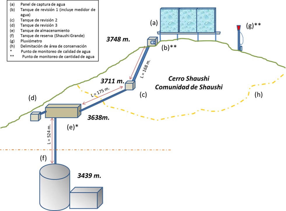
4.1 គំនូសបច្ចេកទេសនៃបច្ចេកទេសនេះ
ឈ្មោះអ្នកនិពន្ធ:
General diagram of the practice
កាលបរិច្ឆេទ:
01/05/2017
4.2 លក្ខណៈពិសេសនៃបច្ចេកទេស/ ពណ៌នាពីគំនូរបច្ចេកទេស
Dimensions
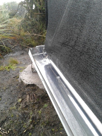
Capture Panel Review and Breakthrough Tanks
Height = 4 m. length = 1.0 m.
Length = 10 m. width = 1.0 m.
depth = 1.0 m.
Driving line storage tank
Length = 343 m. length = 3 m.
Diameter = 32 mm. width = 2 m.
depth = 2 m.
Tank capacity Overhaul and breaker tanks
Volume = 1 m3
Storage tank
Volume = 12 m3
Slope angle: Mostly the terrain of the practice implantation zone is 30-40%.
Construction material used: Galvanized steel pipes, zaran mesh, cement, stone, sand and gravel, PVC pipes, fittings (keys, elbows, valves, etc.), iron stakes for supports, tensioners, tol lids for tanks.
Area 137 ha, owned by Shaushi Community
Altitude range approx. 3400-3700 m
Slope range 30 - 40 %.
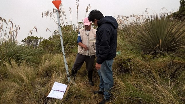
Parameters considered: pH, conductivity, total dissolved solids, water temperature, precipitation and flow.
Monitoring points water storage tank.
1) Precipitation: Nearby of the water capture screen (neblinometer).
2) Flow: to one side of the water capture panel (neblinometer).
Monthly frequency
1) Precipitation: Weekly
2) Flow: Weekly
Materials and/or equipment used
1) pH, conductivity, total dissolved solids: Multiparametric equipment.
2) Water temperature: Thermometer and/or multiparametric
equipment
1) Precipitation: Totalizer rain gauge (wooden stake, plastic bottle, mangueta, measuring probe.
2) Flow: Micrometer (water meter).
4.3 ព័ត៌មានទូទៅដែលពាក់ព័ន្ធនឹងការគណនាធាតុចូល និងថ្លៃដើម
កំណត់របៀបនៃការគណនាថ្លៃដើម និងធាតុចូល:
- ក្នុងតំបន់អនុវត្តបច្ចេកទេស
កំណត់រូបិយប័ណ្ណសម្រាប់ថ្លៃដើម:
- ដុល្លារអាមេរិក
កំណត់ថ្លៃឈ្នួលជាមធ្យមនៃការជួលកម្លាំងពលកម្មក្នុងមួយថ្ងៃ:
10-20
4.4 សកម្មភាពបង្កើត
| សកម្មភាព | ប្រភេទវិធានការ | ពេលវេលា | |
|---|---|---|---|
| 1. | Installation of fog water capture system | រចនាសម្ព័ន្ធ | Only once the site has been identified. |
| 2. | Declaration of conservation and protection area in the area of implementation of the practice | ការគ្រប់គ្រង | Only once the area of interest has been identified. |
| 3. | Participatory monitoring of water quality and quantity. | ផ្សេងៗ | Amount of water: weekly Water quality: monthly |
មតិយោបល់:
The most relevant activities carried out for the implementation of the practice are considered. In the following paragraphs the declaration activity of the conservation area will not be considered due to the fact that it is an inter-institutional management activity only.
4.5 ថ្លៃដើម និងធាតុចូលដែលត្រូវការសម្រាប់ការបង្កើតបច្ចេកទេស
បើអាច បំបែកថ្លៃដើមនៃការចាប់ផ្តើមទៅតាមតារាងខាងក្រោម កំណត់ធាតុចូល និងថ្លៃដើមក្នុងមួយឯកតា។ បើអ្នកមិនអាចបំបែកបាន សូមផ្តល់នូវតម្លៃប៉ាន់ស្មានក្នុងការបង្កើតបច្ចេកទេសជាតម្លៃសរុប:
33238,86
| បញ្ជាក់ពីធាតុចូល | ឯកតា | បរិមាណ | ថ្លៃដើមក្នុងមួយឯកតា | ថ្លៃធាតុចូលសរុប | % នៃថ្លៃដើមដែលចំណាយដោយអ្នកប្រើប្រាស់ដី | |
|---|---|---|---|---|---|---|
| កម្លាំងពលកម្ម | Construction and installation of the elements of the water capture system. Skilled and unskilled labor. | 1 | 1,0 | 26176,33 | 26176,33 | 3,4 |
| កម្លាំងពលកម្ម | Water quality and quantity monitoring (measurements) | 1 | 1,0 | 500,0 | 500,0 | 100,0 |
| សម្ភារៈ | Miscellaneous materials for the construction and installation of the water harvesting system | 1 | 1,0 | 2012,53 | 2012,53 | |
| សម្ភារៈ | Materials and equipment for water quality and quantity sampling and measurements | 1 | 1,0 | 4550,0 | 4550,0 | |
| ថ្លៃដើមសរុបក្នុងការបង្កើតបច្ចេកទេស | 33238,86 | |||||
ប្រសិនបើអ្នកប្រើប្រាស់ដីមិនមានថ្លៃដើម 100% សូមបញ្ជាក់ថានរណាដែលចំណាយថ្លៃដើមដែលនៅសល់:
The cooperating entities for the application of the practice were: CONDESAN, Ministry of Environment MAE (Project GIDACC), FMPLPT, Autonomous Decentralized Municipal Government of the canton Santiago Quero and the Commonwealth of FSO.
មតិយោបល់:
The costs were estimated on the basis of the information available from the cooperating entities.
4.6 សកម្មភាពថែទាំ
| សកម្មភាព | ប្រភេទវិធានការ | ពេលវេលា/ ភាពញឹកញាប់ | |
|---|---|---|---|
| 1. | Review of fog water capture system and additional elements for monitoring. | ផ្សេងៗ | weekly |
| 2. | Repair and/or replacement of deteriorated or damaged elements. | រចនាសម្ព័ន្ធ | when necessary |
4.7 កំណត់ថ្លៃដើមសម្រាប់ការថែទាំ/ សកម្មភាពរបស់បច្ចេកទេស (ក្នុងរយៈពេលមួយឆ្នាំ)
បើអាច បំបែកថ្លៃដើមនៃការថែទាំទៅតាមតារាងខាងក្រោម បញ្ជាក់ធាតុចូលលម្អិត និងថ្លៃដើមក្នុងមួយឯកតា។ បើអ្នកមិនអាចបំបែកបាន សូមផ្តល់នូវតម្លៃប៉ាន់ស្មាននៃការថែទាំបច្ចេកទេសសរុប:
4900,0
ប្រសិនបើអ្នកប្រើប្រាស់ដីមិនមានថ្លៃដើម 100% សូមបញ្ជាក់ថានរណាដែលចំណាយថ្លៃដើមដែលនៅសល់:
The costs so far have been assumed by the Technical Unit of the Commonwealth of Southern Western Front.
មតិយោបល់:
It is proposed that an agreement be made with the community to establish responsibilities for the maintenance of the practice.
4.8 កត្តាសំខាន់បំផុតដែលមានឥទ្ធិពលដល់ការចំណាយ
ពណ៌នាពីកត្តាប៉ះពាល់ចម្បងៗទៅលើថ្លៃដើម:
According to the perception of the beneficiaries, the most important factor that can affect the system and therefore the costs, are the environmental conditions of the area, especially the presence of strong winds that could mainly affect the water capture panel fog.
5. លក្ខណៈបរិស្ថានធម្មជាតិ និងមនុស្ស
5.1 អាកាសធាតុ
បរិមាណទឹកភ្លៀងប្រចាំឆ្នាំ
- < 250 មម
- 251-500 មម
- 501-750 មម
- 751-1,000 មម
- 1,001-1,500 មម
- 1,501-2,000 មម
- 2,001-3,000 មម
- 3,001-4,000 មម
- > 4,000 មម
កំណត់បរិមាណទឹកភ្លៀង (បើដឹង) ជា មីលីម៉ែត្រ:
615,00
លក្ខណៈពិសេស/ មតិយោបល់លើរដូវភ្លៀង:
In the Inter-Andean region the Rainy Period presents a bimodal distribution, presenting a Secondary Rainy Period during the months of September to November and the Main Rainy Period during the months of February to May.
បញ្ជាក់ឈ្មោះឯកសារយោងនៃស្ថានីយឧតុនិយម:
Querochaca and Huambalo from INAMHI
តំបន់កសិអាកាសធាតុ
- មានភ្លៀងមធ្យម
The agroclimatic zone was determined based on the information of the biophysical characterization provided in the Diagnosis of the Quero Canton in the Cubillo Paulina Grade Thesis.
5.2 សណ្ឋានដី
ជម្រាលជាមធ្យម:
- រាបស្មើ (0-2%)
- ជម្រាលតិចតួច (3-5%)
- មធ្យម (6-10%)
- ជម្រាលខ្ពស់បន្តិច (11-15%)
- ទីទួល (16-30%)
- ទីទួលចោត (31-60%)
- ទីទួលចោតខ្លាំង (>60%)
ទម្រង់ដី:
- ខ្ពង់រាប
- កំពូលភ្នំ
- ជម្រាលភ្នំ
- ជម្រាលទួល
- ជម្រាលជើងភ្នំ
- បាតជ្រលងភ្នំ
តំបន់តាមរយៈកម្ពស់ :
- 0-100 ម
- 101-500 ម
- 501-1,000 ម
- 1,001-1,500 ម
- 1,501-2,000 ម
- 2,001-2,500 ម
- 2,501-3,000 ម
- 3,001-4,000 ម
- > 4,000 ម
បញ្ជាក់ថាតើបច្ចេកទេសនេះត្រូវបានអនុវត្តន៍នៅក្នុង:
- សណ្ឋានដីប៉ោង
មតិយោបល់ និងបញ្ចាក់បន្ថែមអំពីសណ្ឋានដី :
The actions carried out as part of the practice are located in an area with rugged topography, mostly in convex areas.
5.3 ដី
ជម្រៅដីជាមធ្យម:
- រាក់ខ្លាំង (0-20 សម)
- រាក់ (21-50 សម)
- មធ្យម (51-80 សម)
- ជ្រៅ (81-120 សម)
- ជ្រៅខ្លាំង (> 120 សម)
វាយនភាពដី (ស្រទាប់លើ):
- គ្រើម/ មានពន្លឺ (ខ្សាច់)
- ម៉ត់/ ធ្ងន់ (ឥដ្ឋ)
វាយនភាពដី (> 20 សម ស្រទាប់ក្នុង):
- គ្រើម/ មានពន្លឺ (ខ្សាច់)
- ម៉ត់/ ធ្ងន់ (ឥដ្ឋ)
សារធាតុសរីរាង្គនៅស្រទាប់ដីខាងលើ:
- ខ្ពស់ (>3%)
បើអាចសូមភ្ជាប់ការពណ៌នាពីដីឱ្យបានច្បាស់ ឬព័ត៌មានដែលអាចទទួលបាន ឧ. ប្រភេទដី, pH ដី/ ជាតិអាស៊ីត, សមត្ថភាពផ្លាស់ប្តូរកាចុង, វត្តមាននីត្រូសែន, ភាពប្រៃ ។ល។:
The soils of Quero are volcanic and are mainly differentiated by the parental material: there are soils formed in recent volcanic ash (Andosoles: northern and central soils) and soils formed in meteorized metamorphic rock (Inceptisoles: southern soils).
Specifically they are evidenced from Udic Eutrandepts soils (Hv) and their characteristics are: isothermal black; francs with fine to medium sand with clear presence of silt; 4 to 5% organic matter from 0 to 20 cm; deep (1m); friable; well drained; water retention from 10 to 20%; neutral pH; medium natural fertility.
In this area, also have an Entic Distrandepts soils (Dny) and their characteristics are: with content of coarse pumice sand in more than 35% over the whole profile. Moderate to high water retention capacity, 50 to 80%; very black; loamy pseudo-silt textures; deep; well drained.
5.4 ទឹកដែលអាចទាញមកប្រើប្រាស់បាន និងគុណភាពទឹក
នីវ៉ូទឹកក្រោមដី:
ផ្ទៃខាងលើ
ទឹកលើដីដែលអាចទាញយកប្រើប្រាស់បាន:
កម្រិតមធ្យម
គុណភាពទឹក (មិនបានធ្វើប្រត្តិកម្ម):
ទឹកពិសារដែលគ្មានគុណភាព (តម្រូវឱ្យមានការសំអាត)
តើមានបញ្ហាភាពទឹកប្រៃហូរចូលមកដែរឬទេ?
ទេ
តើទឹកជំនន់កំពុងកើតមាននៅតំបន់នេះដែររឺទេ?
ទេ
មតិយោបល់ និងលក្ខណៈពិសេសផ្សេងៗទៀតលើគុណភាព និងបរិមាណទឹក :
The monitoring of the captured water is currently being carried out, with the result that up to now the water is of acceptable quality. There is no specific groundwater information available for the area. It is estimated that the soil is not very permeable and the aquifers are very localized (INAMHI, 2015).
5.5 ជីវៈចម្រុះ
ភាពសម្បូរបែបនៃប្រភេទ:
- កម្រិតមធ្យម
ភាពសម្បូរបែបនៃទីជម្រក:
- កម្រិតមធ្យម
មតិយោបល់ និងលក្ខណៈពិសេសផ្សេងទៀតលើជីវចម្រុះ:
In order to determine the diversity of the practice area, the following data are considered: The Sierra del Ecuador region is characterized for being crossed by knots and high mountain chains (with their moors), which have their own biodiversity and diversity of environments and habitats, due to isolation. The ecosystem maintains shrub and herbaceous vegetation (Mena and Medina, 2001). The moor in Quero canton has an evident fragility, due to the constant expansion of the agricultural frontier, overgrazing, burning of grasslands, deforestation, etc., so that the area destined for conservation and protection in the Community of Shaushi is only a remnant of this ecosystem (GAD Quero, 2014).
5.6 លក្ខណៈនៃអ្នកប្រើប្រាស់ដីដែលអនុវត្តបច្ចេកទេស
នៅមួយកន្លែង ឬពនេចរ :
- នៅមួយកន្លែង
ទីផ្សារនៃប្រព័ន្ធផលិតកម្ម:
- ពាក់កណ្តាលពាណិជ្ជកម្ម (ផ្គត់ផ្គង់ខ្លួនឯង/ ពាណិជ្ជកម្ម
ចំណូលក្រៅកសិកម្ម:
- តិចជាង 10% នៃចំណូល
ឯកជន ឬក្រុម:
- ធ្វើខ្លួនឯង/ គ្រួសារ
- ជាក្រុម/ សហគមន៍
កម្រិតប្រើប្រាស់គ្រឿងយន្ត:
- ប្រើកម្លាំងពលកម្ម
- គ្រឿងយន្ត/ ម៉ាស៊ីន
យេនឌ័រ:
- ស្ត្រី
- បុរស
អាយុរបស់អ្នកប្រើប្រាស់ដី:
- វ័យកណ្តាល
សូមបញ្ជាក់ពីលក្ខណៈពាក់ព័ន្ធផ្សេងទៀតអំពីអ្នកប្រើប្រាស់ដី:
In order to determine the relative level of poverty, data are taken from the 2010 National Census conducted by INEC, which indicates that the percentage of poor due to unsatisfied basic needs in Quero canton is 84.5% (GAD Quero, 2014; SNI, 2017). The components or dimensions: (i) quality of housing, (ii) overcrowding, (iii) access to basic services, (iv) access to education and (v) economic capacity (INEC, 2016).
5.7 ទំហំផ្ទៃដីជាមធ្យមនៃដីផ្ទាល់ខ្លួន ឬជួលគេដែលបានអនុវត្តបច្ចេកទេស
- < 0.5 ហិកតា
- 0.5-1 ហិកតា
- 1-2 ហិកតា
- 2-5 ហិកតា
- 5-15 ហិកតា
- 15-50 ហិកតា
- 50-100 ហិកតា
- 100-500 ហិកតា
- 500-1,000 ហិកតា
- 1,000-10,000 ហិកតា
- > 10,000 ហិកតា
តើផ្ទៃដីនេះចាត់ទុកជាទំហំកម្រិតណាដែរ ខ្នាតតូច មធ្យម ឬខ្នាតធំ (ធៀបនឹងបរិបទតំបន់)?
- ខ្នាតតូច
មតិយោបល់:
The inhabitants of the Shaushi Community have an average area of less than 3 ha.
5.8 ភាពជាម្ចាស់ដី កម្មសិទ្ធប្រើប្រាស់ដី និងកម្មសិទ្ធប្រើប្រាស់ទឹក
- mixed
- mixed
កម្មសិទ្ធប្រើប្រាស់ទឹក:
- ជាក្រុម (មានដែនកំណត់)
មតិយោបល់:
In the area of direct influence (Shaushi Community) the lands are individual property except for the area destined for conservation and protection which is communal.
5.9 ការប្រើប្រាស់សេវាកម្ម និងហេដ្ឋារចនាសម្ព័ន្ធ
សុខភាព:
- មិនល្អ
- មធ្យម
- ល្អ
ការអប់រំ:
- មិនល្អ
- មធ្យម
- ល្អ
ជំនួយបច្ចេកទេស:
- មិនល្អ
- មធ្យម
- ល្អ
ការងារ (ឧ. ការងារក្រៅកសិដ្ឋាន):
- មិនល្អ
- មធ្យម
- ល្អ
ទីផ្សារ:
- មិនល្អ
- មធ្យម
- ល្អ
ថាមពល:
- មិនល្អ
- មធ្យម
- ល្អ
ផ្លូវ និងការដឹកជញ្ជូន:
- មិនល្អ
- មធ្យម
- ល្អ
ទឹកផឹក និងអនាម័យ:
- មិនល្អ
- មធ្យម
- ល្អ
សេវាកម្មហិរញ្ញវត្ថុ:
- មិនល្អ
- មធ្យម
- ល្អ
6. ផលប៉ះពាល់ និងការសន្និដ្ឋាន
6.1 ផលប៉ះពាល់ក្នុងបរិវេណអនុវត្តបច្ចេកទេសដែលកើតមាន
ផលប៉ះពាល់លើសេដ្ឋកិច្ចសង្គម
ទឹកដែលអាចទាញមកប្រើប្រាស់បាន និងគុណភាពទឹក
ទឹកបរិភោគដែលអាចទាញយកមកប្រើប្រាស់បាន
គុណភាពទឹកបរិភោគ
ផលប៉ះពាល់ទៅលើវប្បធម៌សង្គម
ស្ថានភាពសុខភាព
កម្មសិទ្ធដីប្រើប្រាស់/ ទឹក
ស្ថាប័នសហគមន៍
ចំណេះដឹង SLM / ការធ្លាក់ចុះគុណភាពដី
ការកាត់បន្ថយជម្លោះ
ផលប៉ះពាល់ទៅលើអេកូឡូស៊ី
វដ្តទឹក/លំហូរ
បរិមាណទឹក
គុណភាពទឹក
ការប្រមូលស្តុកទុកទឹក
ដី
សំណើមដី
គម្របដី
ដីហាប់
ជីវចម្រុះ៖ ដំណាំ, សត្វ
ដំណាំគម្រប
ភាពសម្បូរបែបនៃរុក្ខជាតិ
ការកាត់បន្ថយហានិភ័យនៃគ្រោះមហន្តរាយ និងគ្រោះអាកាសធាតុ
ផលប៉ះពាល់នៃគ្រោះរាំងស្ងួត
ការបំភាយនៃកាបូន និងឧស្ម័នផ្ទះកញ្ចក់
អាកាសធាតុ
6.2 ផលប៉ះពាល់ក្រៅបរិវេណអនុវត្តបច្ចេកទេសដែលកើតមាន
ទឹកដែលអាចទាញមកប្រើប្រាស់បាន
លំហូរទឹកដែលអាចប្រើប្រាស់បាននៅរដូវប្រាំង
បញ្ជាក់បន្ថែមការវាយតម្លៃផលប៉ះពាល់:
Impacts that have been classified as insignificant are thus valued because they are impacts expected by the practices considering their scope, but which have not been measured or perceived by the population as opposed to the impacts valued at the time of analysis.
6.3 ភាពប្រឈម និងភាពរួសនៃបច្ចេកទេសទៅនឹងការប្រែប្រួលអាកាសធាតុ និងគ្រោះអាកាសធាតុ/ គ្រោះមហន្តរាយ (ដែលដឹងដោយអ្នកប្រើប្រាស់ដី)
ការប្រែប្រួលអាកាសធាតុ
ការប្រែប្រួលអាកាសធាតុ
| រដូវកាល | ប្រភេទនៃការប្រែប្រួលអាកាសធាតុ/ព្រឹត្តិការណ៍ | លក្ខណៈឆ្លើយតបនៃបច្ចេកទេសទៅនឹងការប្រែប្រួលអាកាសធាតុ | |
|---|---|---|---|
| សីតុណ្ហភាពប្រចាំឆ្នាំ | កើនឡើង | មិនស្គាល់ | |
| បរិមាណទឹកភ្លៀងប្រចាំឆ្នាំ | កើនឡើង | ល្អ | |
| ការប្រែប្រួលអាកាសធាតុផ្សេងៗ | Loss of seasonality | កើនឡើង | មិនស្គាល់ |
គ្រោះអាកាសធាតុ (មហន្តរាយ)
គ្រោះមហន្តរាយអាកាសធាតុ
| លក្ខណៈឆ្លើយតបនៃបច្ចេកទេសទៅនឹងការប្រែប្រួលអាកាសធាតុ | |
|---|---|
| រលកត្រជាក់ | ល្អ |
6.4 ការវិភាគថ្លៃដើម និងអត្ថប្រយោជន៍
តើផលចំណេញ និងថ្លៃដើមត្រូវបានប្រៀបធៀបគ្នាយ៉ាងដូចម្តេច (ទស្សនៈរបស់អ្នកប្រើប្រាស់ដី)?
រយៈពេលខ្លី:
វិជ្ជមានខ្លាំង
រយៈពេលវែង:
វិជ្ជមានខ្លាំង
តើផលចំណេញ និងការថែទាំ/ ជួសជុលត្រូវបានប្រៀបធៀបគ្នាយ៉ាងដូចម្តេច (ទស្សនៈរបស់អ្នកប្រើប្រាស់ដី)?
រយៈពេលខ្លី:
វិជ្ជមានខ្លាំង
រយៈពេលវែង:
វិជ្ជមានខ្លាំង
មតិយោបល់:
The most plausible benefit for the population of the Shaushi Community is the availability of water for human consumption for the inhabitants who did not have it, so the comparison in terms of costs is assumed in the case of not having the practice, which would represent carrying out a project to transport the water from another geographical point, which would be more costly. On the other hand, the perceived benefits also include environmental and health benefits, which are not quantified economically, thanks to the conservation of the area of implantation of the practice.
6.5 ការទទួលយកបច្ចេកទេស
- ច្រើនជាង 50%
បើអាច សូមបញ្ជាក់ពីបរិមាណ (ចំនួនគ្រួសារ និង/ ឬតំបន់គ្របដណ្តប់):
23
ក្នុងចំណោមគ្រួសារទាំងអស់ដែលអនុវត្តបច្ចេកទេស តើមានប៉ុន្មានគ្រួសារដែលចង់ធ្វើដោយខ្លួនឯង ដោយមិនទទួលបានសម្ភារៈលើកទឹកចិត្ត/ប្រាក់ឧបត្ថម្ភ?:
- 90-100%
មតិយោបល់:
The decision to adopt the practice was made within the Shaushi Community (beneficiaries) for those who did not have the service, where the villagers understood the need to allocate the area for conservation and protection considering the benefits it provides, and the advantage of having a system that would provide water for the consumption of the villagers who did not have the resource.
6.6 ការបន្សុំា
តើថ្មីៗនេះ បច្ចេកទេសនេះត្រូវបានកែតម្រូវដើម្បីបន្ស៊ាំទៅនឹងស្ថានភាពប្រែប្រួលដែរឬទេ?
បាទ/ចា៎
ផ្សេងៗ (សូមបញ្ជាក់):
Climatic conditions, terrain and structure of the water capture panel.
បញ្ជាក់ពីការបន្ស៊ាំនៃបច្ចេកទេស (ការរៀបចំ, ឧបករណ៍/ប្រភេទ ។ល។):
The dimensions of the excavations were reviewed to place the holders and turnbuckles, considering the slope and shape of the relief so that the system is stable.
6.7 ភាពខ្លាំង/ គុណសម្បត្តិ/ ឱកាសនៃបច្ចេកទេស
| ភាពខ្លាំង/ គុណសម្បត្តិ/ ឱកាសនៅកន្លែងរបស់អ្នកប្រើប្រាស់ដី |
|---|
| The commitment of the inhabitants of the community to preserve the environment and specifically the protection area that provides them with water in quantity and quality. |
| The water capture system provides them with direct benefits in terms of the availability of drinking water for this zone. |
| Participatory monitoring is beneficial because it allows them to control the quality and quantity of water that the system can provide. |
| ភាពខ្លាំង/ គុណសម្បត្តិ/ ឱកាស ទស្សនៈរបស់បុគ្គលសំខាន់ៗ |
|---|
| Plant restoration trials can be carried out to improve knowledge in these ecosystems, which were intervened and which are subsequently destined for conservation. |
| It is possible to investigate how a natural ecosystem in conservation interacts with the areas in its surroundings that are highly intervened and how it could affect it. |
| Decrease in dependence on other water sources for sustainable management of soil and other resources. |
| Investigations can be carried out based on the measurements and analysis of water quantity and quality carried out and to be carried out. Analysis of soil moisture and other elements may be included. |
| Implementation of other practices for research and/or sustainable use of soil and water, with high community participation. |
| The community can be strengthened with respect to issues related to the conservation of these ecosystems and the services they provide, so that they can be properly managed and managed. |
6.8 ភាពខ្សោយ/ គុណវិបត្តិ/ ហានិភ័យនៃបច្ចេកទេស និងវិធីសាស្ត្រដោះស្រាយ
| ភាពខ្សោយ/ គុណវិបត្តិ/ ហានិភ័យ ទស្សនៈរបស់អ្នកប្រើប្រាស់ដី | តើបច្ចេកទេសទាំងនោះបានដោះស្រាយបញ្ហាដូចម្តេច? |
|---|---|
| Some users do not respect the rules established for the management of the area destined for conservation, and residues from past activities are still observed. | Sanctions can be established for the presence of any improper action, however, in parallel with the practice, training should continue to involve users more in the review and maintenance activities, in order to achieve a better result. |
| The environmental conditions of the site, especially the strength of the wind in the area. | It is being continuously reviewed to detect any impact on the system, especially on the water capture panel, which could break or become dislocated. |
| In the water capture panel fog, due to the height of the water collection gutter, it splashes in heavy rain events allowing soil to enter into the system from the ground. The same factor when the system becomes saturated or plugged the water overflows into the gutter, so collection is sometimes inefficient. | The functionality of the system is being reviewed, if necessary any modifications will be made in coordination with the community. |
| ភាពខ្សោយ/ គុណវិបត្តិ/ ហានិភ័យ ទស្សនៈរបស់អ្នកចងក្រងឬបុគ្គលសំខាន់ៗ | តើបច្ចេកទេសទាំងនោះបានដោះស្រាយបញ្ហាដូចម្តេច? |
|---|---|
| Lack of a preventive and corrective maintenance plan to maintain optimal conditions. | It is neccesary to include a preventive and corrective maintenance plan that should be agreed between the technical area of the cooperating entities and with the users of the communities for its application. |
| The practice of permanent monitoring is insufficient, because data collection is minimal. | The cooperating entities and community authorities can establish a monitoring action plan that covers several lines, including infrastructure such as monitoring for research purposes. |
7. ឯកសារយោង និងវេបសាយ
7.1 វិធីសាស្ត្រ/ ប្រភពនៃព័ត៌មាន
- តាមការចុះទីវាល ការស្រាវជ្រាវនៅទីវាល
Land users and technicians from cooperating entities were interviewed.
- ការសម្ភាសន៍ជាមួយអ្នកប្រើប្រាស់ដី
3 land users, one of them is the President of the Junta de Agua Potable.
- ការសម្ភាសន៍ជាមួយអ្នកជំនាញ/ ឯកទេស
Three technicians from the cooperating entities: Mancomunidad FSO and Fondo de Páramos.
- ការចងក្រងពីរបាកការណ៍ និងឯកសារផ្សេងៗទៀតដែលមាន
The documents used include technical reports prepared by the technicians of the Fondo de Páramos, reports and terms of reference prepared by the Technical Unit of the FSO.
7.2 ឯកសារយោងដែលបានចេញផ្សាយ
ចំណងជើង អ្នកនិពន្ធ ឆ្នាំ ISBN:
"Los páramos del Ecuador". Mena Vásconez Patricio y Medina Galo. 2001. Abya-Yala / Proyecto Páramo, Quito.
មានប្រភពមកពីណា? ថ្លៃដើមប៉ុន្មាន?
Available for free online: https://www.portalces.org/sites/default/files/references/044_Mena%20et%20al.%20(Eds.).%20%202001.Paramos%20Ecuador%20PORTADA%2B_%2BHOJA%2BTECNICA%2BY%2BPRESENTACION.pdf
ចំណងជើង អ្នកនិពន្ធ ឆ្នាំ ISBN:
"La biodiversidad en el Ecuador". Bravo Velásquez Elizabeth. 2014. Universidad Politécnica Salesiana. Cuenca-Ecuador.
មានប្រភពមកពីណា? ថ្លៃដើមប៉ុន្មាន?
Available for free online: https://dspace.ups.edu.ec/handle/123456789/6788
ចំណងជើង អ្នកនិពន្ធ ឆ្នាំ ISBN:
Actualización Plan de Desarrollo y Ordenamiento Territorial-Quero 2014. Gobierno Autónomo Descentralizado Municipal del Cantón Quero. 2014.
មានប្រភពមកពីណា? ថ្លៃដើមប៉ុន្មាន?
Available for free online: http://app.sni.gob.ec/sni-link/sni/PORTAL_SNI/data_sigad_plus/sigadplusdiagnostico/1860000800001_PDYOT%20QUERO%20CONSOLIDADO_19-04-2015_20-19-44.pdf
ចំណងជើង អ្នកនិពន្ធ ឆ្នាំ ISBN:
Informe de implementación de un sistema de captura de agua niebla en la comunidad de Shaushi, en el cantón Quero. Guevara Rocío. 2017. Fondo de Manejo de Páramos y Lucha contra la pobreza Tungurahua.
មានប្រភពមកពីណា? ថ្លៃដើមប៉ុន្មាន?
In the archives of the Tungurahua Wetland Fund and Fight against Poverty in the GAD of the province of Tungurahua.
ចំណងជើង អ្នកនិពន្ធ ឆ្នាំ ISBN:
Informe y base de datos de Shaushi y Llimpes, que incluye la línea base llena y estructurada de acuerdo a los lineamientos de CONDESAN. Calle Juan. 2017. CONDESAN.
មានប្រភពមកពីណា? ថ្លៃដើមប៉ុន្មាន?
In the archives of the Consortium for Sustainable Development of the Andean Ecoregion CONDESAN.
ចំណងជើង អ្នកនិពន្ធ ឆ្នាំ ISBN:
Informe final de “Construcción de un sistema de captura de agua niebla en la comunidad de Shaushi, cantón Quero”. Mancomunidad de GADs municipales “Frente Sur Occidental” de la provincia de Tungurahua. 2017.
មានប្រភពមកពីណា? ថ្លៃដើមប៉ុន្មាន?
In the archives of the Technical Unit of the Mancomunidad de GADs municipales "Frente Sur Occidental" of the province of Tungurahua.
ចំណងជើង អ្នកនិពន្ធ ឆ្នាំ ISBN:
Manual de monitoreo hídrico participativo. Calles Juan. 2016. CONDESAN.
មានប្រភពមកពីណា? ថ្លៃដើមប៉ុន្មាន?
In the archives of the Consortium for Sustainable Development of the Andean Ecoregion CONDESAN.
ចំណងជើង អ្នកនិពន្ធ ឆ្នាំ ISBN:
Reporte de Pobreza y Desigualdad. Diciembre 2016. INEC. Dirección responsable de la información estadística y contenidos: Dirección de Innovación en Métricas y Metodologías.
មានប្រភពមកពីណា? ថ្លៃដើមប៉ុន្មាន?
Available for free online: https://www.ecuadorencifras.gob.ec/documentos/web-inec/POBREZA/2016/Diciembre_2016/Reporte%20pobreza%20y%20desigualdad-dic16.pdf
ចំណងជើង អ្នកនិពន្ធ ឆ្នាំ ISBN:
Ubicación del Nuevo Relleno Sanitario en base a criterios ambientales, socioeconómicos y técnicos, y propuesta de Plan de Reciclaje en la ciudad de Quero, Cantón Quero Provincia del Tungurahua. Cubillo Paulina. 2005. Escuela Politécnica del Ejército.
មានប្រភពមកពីណា? ថ្លៃដើមប៉ុន្មាន?
Available for free online: http://repositorio.espe.edu.ec/xmlui/handle/21000/722
ចំណងជើង អ្នកនិពន្ធ ឆ្នាំ ISBN:
Introducción a la Hidrogeología del Ecuador (Segunda Versión). Burbano Napoléon, Becerra Simón, Pasquel Efrén. 2014. INAMHI
មានប្រភពមកពីណា? ថ្លៃដើមប៉ុន្មាន?
Available for free online: http://www.serviciometeorologico.gob.ec/Publicaciones/Hidrologia/HIDROGEOLOGIA_2%20EDICION_2014.pdf
7.3 ចូលទៅទាញយកឯកសារដែលពាក់ព័ន្ធតាមបណ្តាញអ៊ិនធឺណែត
ចំណងជើង/ ពណ៌នា:
Anuarios meteorológicos del Instituto Nacional de Meteorología e Hidrología INAMHI.
វេបសាយ:
http://www.forosecuador.ec/forum/ecuador/educaci%C3%B3n-y-ciencia/35393-inamhi-anuarios-metereol%C3%B3gicos-en-pdf
ចំណងជើង/ ពណ៌នា:
Boletín Anual del Instituto Nacional de Meteorología e Hidrología INAMHI.
វេបសាយ:
http://www.serviciometeorologico.gob.ec/boletin-anual/
ចំណងជើង/ ពណ៌នា:
Indicadores de pobreza del INEC 2010. Sistema Nacional de Información.
វេបសាយ:
http://indestadistica.sni.gob.ec/QvAJAXZfc/opendoc.htm?document=SNI.qvw&host=QVS@kukuri&anonymous=truehttp://indestadistica.sni.gob.ec/QvAJAXZfc/opendoc.htm?document=SNI.qvw&host=QVS@kukuri&anonymous=true&bookmark=Document/BM27
ចំណងជើង/ ពណ៌នា:
Sistema Nacional de Información. Página de la Secretaría Nacional de Planificación y Desarrollo del Ecuador
វេបសាយ:
http://app.sni.gob.ec/web/menu/
ការតភ្ជាប់ និងម៉ូឌុល
ពង្រីកមើលទាំងអស់ បង្រួមទាំងអស់ការតភ្ជាប់
គ្មានការតភ្ជាប់
ម៉ូឌុល
គ្មានម៉ូឌុល