Implementation of a fog water capture system in a conservation area in the community of Shaushi. [Equateur]
- Création :
- Mise à jour :
- Compilateur : Raul Galeas
- Rédacteur : –
- Examinateurs : Tatenda Lemann, Johanna Jacobi
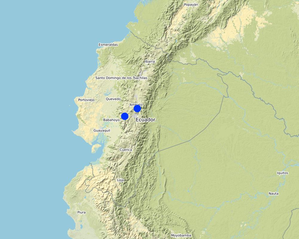
Shaushi Community, La Matriz Parish, Canton Quero, Province of Tungurahua.
technologies_4050 - Equateur
Voir les sections
Développer tout Réduire tout1. Informations générales
1.2 Coordonnées des personnes-ressources et des institutions impliquées dans l'évaluation et la documentation de la Technologie
Personne(s)-ressource(s) clé(s)
Galeas Raul
0986027084
raul12hc@gmail.com
CONDESAN
Calle Germán Alemán E12-123 y Carlos Arroyo del Río.
Equateur
1.3 Conditions relatives à l'utilisation par WOCAT des données documentées
Quand les données ont-elles été compilées (sur le terrain)?
01/05/2017
Le compilateur et la(les) personne(s) ressource(s) acceptent les conditions relatives à l'utilisation par WOCAT des données documentées:
Oui
1.4 Déclaration sur la durabilité de la Technologie décrite
Est-ce que la Technologie décrite ici pose problème par rapport à la dégradation des terres, de telle sorte qu'elle ne peut pas être déclarée comme étant une technologie de gestion durable des terres?
Non
Commentaires:
Land management practice is intended to preserve and restore soil conditions in the area of implementation.
2. Description de la Technologie de GDT
2.1 Courte description de la Technologie
Définition de la Technologie:
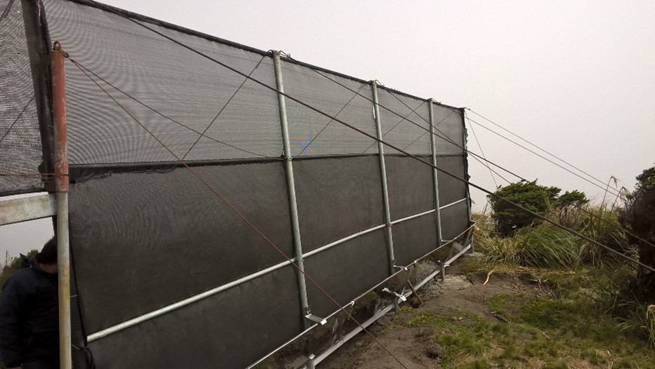
The practice consists in the installation of a water capture system, coming from the fog of the Cerro Shaushi zone, that allows to cover the need of water for domestic consumption of the inhabitants of the upper zone of the Community of Shaushi.
2.2 Description détaillée de la Technologie
Description:
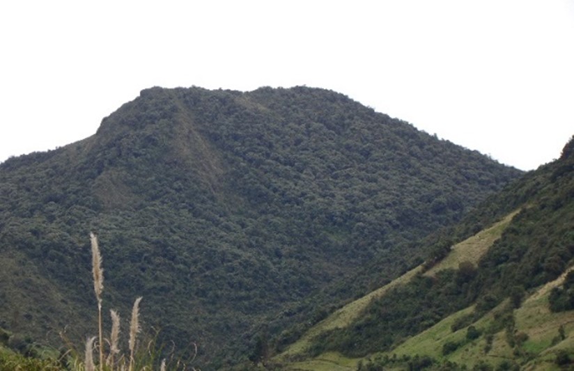
The technology was applied in the Shaushi community in La Matriz parish, Canton Quero, province of Tungurahua. It consists in the installation of fog water capture system, declaration of a conservation and protection area, and participatory monitoring of water quality and quantity. Among the purposes of the technology is to make the population aware of the sustainable use of the territory and of the environmental services it provides, and to motivate them to take an active part in the conservation and protection of natural areas and water sources. Major activities are the periodic revision of the water capture system, repair and/or replacement of deteriorated or destroyed elements, and the continuous evaluation of the functionality of the practice, and continuous monitoring of water quality and quantity. The main benefit is the availability of water for human consumption in quantity and quality, conservation of natural areas, improvement of the relationship between human beings and nature, and to have hydrometeorological information for research purposes. The users of the practice are satisfied with its implementation and the benefits perceived so far, as they have been able to demonstrate the improvements described. As an opportunity for improvement, the need to deepen the knowledge about the páramo ecosystem and its benefits within the community is established. In addition, the initiative to implement this system in other geographical points is proposed, considering its benefits and the natural conditions of the area that make possible the availability of water for the community.
2.3 Photos de la Technologie
Galerie Médias
2.5 Pays/ région/ lieux où la Technologie a été appliquée et qui sont couverts par cette évaluation
Pays:
Equateur
Région/ Etat/ Province:
Tungurahua
Autres spécifications du lieu:
Shaushi
Commentaires:
The reserve tank stores water from the fog water capture system and from the Quintina water source for domestic consumption in the Shuashi Community, with which it can supply the beneficiary population (30 families).
Map
×2.6 Date de mise en œuvre de la Technologie
Si l'année précise est inconnue, indiquez la date approximative: :
- il y a moins de 10 ans (récemment)
2.7 Introduction de la Technologie
Spécifiez comment la Technologie a été introduite: :
- grâce à l'innovation d'exploitants des terres
- au cours d'expérimentations / de recherches
- par le biais de projets/ d'interventions extérieures
Commentaires (type de projet, etc.) :
This practice was established thanks to the management carried out by the "Mancomunidda del Frente Sur Occidental", "Fondo de Páramos de Tungurahua" and "the international organization Figth Against Poverty", with the financing of cooperating entities such as "Consorcio para el Desarrollo de la Ecorregión Andina" (CONDESAN) and the Ministry of the Environment, however, it was also a decision of the community of Shaushi, who assigned the area of implementation of the practice for conservation purposes.The reserve tank stores water from the fog water capture system and from the Quintina water source for domestic consumption in the Shuashi Community, with which it can supply the beneficiary population (30 families).
3. Classification de la Technologie de GDT
3.1 Principal(aux) objectif(s) de la Technologie
- réduire, prévenir, restaurer les terres dégradées
- préserver l'écosystème
- protéger un bassin versant/ des zones situées en aval - en combinaison avec d'autres technologies
- conserver/ améliorer la biodiversité
- créer un impact social positif
3.2 Type(s) actuel(s) d'utilisation des terres, là où la Technologie est appliquée

Mixte (cultures/ pâturages/ arbres), incluant l'agroforesterie
- Agro-pastoralisme
Principaux produits/ services:
In the area of implementation of the practice outside the conservation area alternately develops short cycle crops mainly and livestock.

Autre
Précisez:
Paramo
Remarques:
The practice was implemented in an area that preserves its natural conditions and is in recovery. This area was declared a conservation and protection area. In the area of implementation of the practice outside the conservation area alternately develops short cycle crops mainly and livestock.
Si l'utilisation des terres a changé en raison de la mise en œuvre de la Technologie, indiquez l'utilisation des terres avant la mise en œuvre de la Technologie:
The area where the practice was implemented was an area that was partially intervened with activities related to agriculture, grazing and forest plantations (native species and pine). Today the area is restricted under a conservation and protection agreement.
3.3 Informations complémentaires sur l'utilisation des terres
Approvisionnement en eau des terres sur lesquelles est appliquée la Technologie:
- mixte: pluvial-irrigué
Commentaires:
The area where the practice is applied does not require irrigation since it is currently under conservation agreement. The area of direct influence, outside the conservation area, in the Shaushi community uses rainwater and the Mocha - Quero Canal irrigation system as irrigation water.
Nombre de période de croissance par an: :
- 2
Précisez:
In the cultivated area the crops (outside the conservation area) are rotated approximately after 4 to 6 months, depending on the product.
Densité d'élevage/ chargement (si pertinent):
In the Shaushi Community, an average of 5-7 cattle per hectare is evident.
3.4 Groupe de GDT auquel appartient la Technologie
- fermeture de zones (arrêt de tout usage, appui à la réhabilitation)
- récupération/ collecte de l'eau
- gestion/ protection des zones humides
3.5 Diffusion de la Technologie
Spécifiez la diffusion de la Technologie:
- appliquée en des points spécifiques ou concentrée sur une petite surface
Commentaires:
The practice of applying a water capture system, although installed in specific points, is accompanied by the declaration of the implantation zone as a conservation and protection area.
3.6 Mesures de GDT constituant la Technologie

structures physiques
- S7: Collecte de l'eau/ approvisionnent en eau/ équipement d'irrigation

modes de gestion
- M1: Changement du type d’utilisation des terres
autres mesures
Commentaires:
Monitoring of water quality and quantity. The measures chosen correspond in the first case to the water capture system and in the second case refers to the declaration of the area of implantation of the practice as a conservation area.
3.7 Principaux types de dégradation des terres traités par la Technologie

dégradation physique des sols
- Pc: compaction

dégradation biologique
- Bc: réduction de la couverture végétale
- Bq: baisse de la quantité/ biomasse
- Bl: perte de la vie des sols

dégradation hydrique
- Ha: aridification
- Hs: changement de la quantité d’eau de surface
- Hp: baisse de la qualité des eaux de surface
- Hq: baisse de la qualité des eaux souterraines
- Hw: réduction de la capacité tampon des zones humides
Commentaires:
The practice avoids that in the area of conservation and sources of water they are intervened by the inhabitants of the Community of Shaushi and by the cattle of their property, with the development of sustainable activities like the capture of fog water that does not affect the availability of the resource. The water supply for domestic use for the inhabitants of Shaushi is currently provided by the Junta de Shaushi, San Vicente and Pueblo Viejo Drinking Water System. However, service coverage is partial; the inhabitants of the upper area of the Shaushi community do not have access to the water because the population has expanded over time to higher altitudes, making it impossible for the system to provide service for technical and infrastructural reasons. However, the population could not be fully supplied and there was a risk of contamination because there was no adequate infrastructure to distribute water for the two required uses.
3.8 Prévention, réduction de la dégradation ou réhabilitation des terres dégradées
Spécifiez l'objectif de la Technologie au regard de la dégradation des terres:
- prévenir la dégradation des terres
- réduire la dégradation des terres
Commentaires:
The practice also includes the sustainable management of soil and territory with the capture of water from the fog, the declaration of this area as an area of conservation and protection that will prevent deep soil degradation.
4. Spécifications techniques, activités, intrants et coûts de mise en œuvre
4.1 Dessin technique de la Technologie
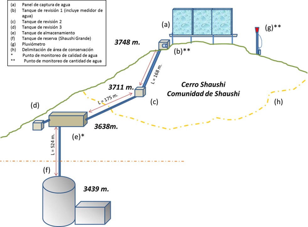
Auteur:
General diagram of the practice
Date:
01/05/2017
4.2 Spécification/ explications techniques du dessin technique
Dimensions
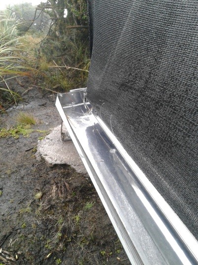
Capture Panel Review and Breakthrough Tanks
Height = 4 m. length = 1.0 m.
Length = 10 m. width = 1.0 m.
depth = 1.0 m.
Driving line storage tank
Length = 343 m. length = 3 m.
Diameter = 32 mm. width = 2 m.
depth = 2 m.
Tank capacity Overhaul and breaker tanks
Volume = 1 m3
Storage tank
Volume = 12 m3
Slope angle: Mostly the terrain of the practice implantation zone is 30-40%.
Construction material used: Galvanized steel pipes, zaran mesh, cement, stone, sand and gravel, PVC pipes, fittings (keys, elbows, valves, etc.), iron stakes for supports, tensioners, tol lids for tanks.
Area 137 ha, owned by Shaushi Community
Altitude range approx. 3400-3700 m
Slope range 30 - 40 %.
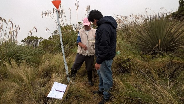
Parameters considered: pH, conductivity, total dissolved solids, water temperature, precipitation and flow.
Monitoring points water storage tank.
1) Precipitation: Nearby of the water capture screen (neblinometer).
2) Flow: to one side of the water capture panel (neblinometer).
Monthly frequency
1) Precipitation: Weekly
2) Flow: Weekly
Materials and/or equipment used
1) pH, conductivity, total dissolved solids: Multiparametric equipment.
2) Water temperature: Thermometer and/or multiparametric
equipment
1) Precipitation: Totalizer rain gauge (wooden stake, plastic bottle, mangueta, measuring probe.
2) Flow: Micrometer (water meter).
4.3 Informations générales sur le calcul des intrants et des coûts
Spécifiez la manière dont les coûts et les intrants ont été calculés:
- par superficie de la Technologie
Indiquez la monnaie utilisée pour le calcul des coûts:
- dollars US
Indiquez le coût salarial moyen de la main d'œuvre par jour:
10-20
4.4 Activités de mise en place/ d'établissement
| Activité | Type de mesures | Calendrier | |
|---|---|---|---|
| 1. | Installation of fog water capture system | Structurel | Only once the site has been identified. |
| 2. | Declaration of conservation and protection area in the area of implementation of the practice | Modes de gestion | Only once the area of interest has been identified. |
| 3. | Participatory monitoring of water quality and quantity. | Autres mesures | Amount of water: weekly Water quality: monthly |
Commentaires:
The most relevant activities carried out for the implementation of the practice are considered. In the following paragraphs the declaration activity of the conservation area will not be considered due to the fact that it is an inter-institutional management activity only.
4.5 Coûts et intrants nécessaires à la mise en place
Si possible, ventilez le coût de la mise en place selon le tableau suivant: spécifiez les intrants et le coût par intrant. Si vous n'êtes pas en mesure de ventiler le coût, donnez une estimation du coût total de la mise en place de la Technologie:
33238,86
| Spécifiez les intrants | Unité | Quantité | Coûts par unité | Coût total par intrant | % du coût supporté par les exploitants des terres | |
|---|---|---|---|---|---|---|
| Main d'œuvre | Construction and installation of the elements of the water capture system. Skilled and unskilled labor. | 1 | 1,0 | 26176,33 | 26176,33 | 3,4 |
| Main d'œuvre | Water quality and quantity monitoring (measurements) | 1 | 1,0 | 500,0 | 500,0 | 100,0 |
| Equipements | Miscellaneous materials for the construction and installation of the water harvesting system | 1 | 1,0 | 2012,53 | 2012,53 | |
| Equipements | Materials and equipment for water quality and quantity sampling and measurements | 1 | 1,0 | 4550,0 | 4550,0 | |
| Coût total de mise en place de la Technologie | 33238,86 | |||||
Si le coût n'est pas pris en charge à 100% par l'exploitant des terres, indiquez qui a financé le coût restant:
The cooperating entities for the application of the practice were: CONDESAN, Ministry of Environment MAE (Project GIDACC), FMPLPT, Autonomous Decentralized Municipal Government of the canton Santiago Quero and the Commonwealth of FSO.
Commentaires:
The costs were estimated on the basis of the information available from the cooperating entities.
4.6 Activités d'entretien/ récurrentes
| Activité | Type de mesures | Calendrier/ fréquence | |
|---|---|---|---|
| 1. | Review of fog water capture system and additional elements for monitoring. | Autres mesures | weekly |
| 2. | Repair and/or replacement of deteriorated or damaged elements. | Structurel | when necessary |
4.7 Coûts et intrants nécessaires aux activités d'entretien/ récurrentes (par an)
Si possible, ventilez le coût de l'entretien selon le tableau suivant: spécifiez les intrants et le coût par intrant. Si vous n'êtes pas en mesure de ventiler le coût, donnez une estimation du coût total de l'entretien de la Technologie:
4900,0
Si le coût n'est pas pris en charge à 100% par l'exploitant des terres, indiquez qui a financé le coût restant:
The costs so far have been assumed by the Technical Unit of the Commonwealth of Southern Western Front.
Commentaires:
It is proposed that an agreement be made with the community to establish responsibilities for the maintenance of the practice.
4.8 Facteurs les plus importants affectant les coûts
Décrivez les facteurs les plus importants affectant les coûts :
According to the perception of the beneficiaries, the most important factor that can affect the system and therefore the costs, are the environmental conditions of the area, especially the presence of strong winds that could mainly affect the water capture panel fog.
5. Environnement naturel et humain
5.1 Climat
Précipitations annuelles
- < 250 mm
- 251-500 mm
- 501-750 mm
- 751-1000 mm
- 1001-1500 mm
- 1501-2000 mm
- 2001-3000 mm
- 3001-4000 mm
- > 4000 mm
Spécifiez la pluviométrie moyenne annuelle (si connue), en mm:
615,00
Spécifications/ commentaires sur les précipitations:
In the Inter-Andean region the Rainy Period presents a bimodal distribution, presenting a Secondary Rainy Period during the months of September to November and the Main Rainy Period during the months of February to May.
Indiquez le nom de la station météorologique de référence considérée:
Querochaca and Huambalo from INAMHI
Zone agro-climatique
- subhumide
The agroclimatic zone was determined based on the information of the biophysical characterization provided in the Diagnosis of the Quero Canton in the Cubillo Paulina Grade Thesis.
5.2 Topographie
Pentes moyennes:
- plat (0-2 %)
- faible (3-5%)
- modéré (6-10%)
- onduleux (11-15%)
- vallonné (16-30%)
- raide (31-60%)
- très raide (>60%)
Reliefs:
- plateaux/ plaines
- crêtes
- flancs/ pentes de montagne
- flancs/ pentes de colline
- piémonts/ glacis (bas de pente)
- fonds de vallée/bas-fonds
Zones altitudinales:
- 0-100 m
- 101-500 m
- 501-1000 m
- 1001-1500 m
- 1501-2000 m
- 2001-2500 m
- 2501-3000 m
- 3001-4000 m
- > 4000 m
Indiquez si la Technologie est spécifiquement appliquée dans des:
- situations convexes
Commentaires et précisions supplémentaires sur la topographie:
The actions carried out as part of the practice are located in an area with rugged topography, mostly in convex areas.
5.3 Sols
Profondeur moyenne du sol:
- très superficiel (0-20 cm)
- superficiel (21-50 cm)
- modérément profond (51-80 cm)
- profond (81-120 cm)
- très profond (>120 cm)
Texture du sol (de la couche arable):
- grossier/ léger (sablonneux)
- fin/ lourd (argile)
Texture du sol (> 20 cm sous la surface):
- grossier/ léger (sablonneux)
- fin/ lourd (argile)
Matière organique de la couche arable:
- abondant (>3%)
Si disponible, joignez une description complète du sol ou précisez les informations disponibles, par ex., type de sol, pH/ acidité du sol, capacité d'échange cationique, azote, salinité, etc.
The soils of Quero are volcanic and are mainly differentiated by the parental material: there are soils formed in recent volcanic ash (Andosoles: northern and central soils) and soils formed in meteorized metamorphic rock (Inceptisoles: southern soils).
Specifically they are evidenced from Udic Eutrandepts soils (Hv) and their characteristics are: isothermal black; francs with fine to medium sand with clear presence of silt; 4 to 5% organic matter from 0 to 20 cm; deep (1m); friable; well drained; water retention from 10 to 20%; neutral pH; medium natural fertility.
In this area, also have an Entic Distrandepts soils (Dny) and their characteristics are: with content of coarse pumice sand in more than 35% over the whole profile. Moderate to high water retention capacity, 50 to 80%; very black; loamy pseudo-silt textures; deep; well drained.
5.4 Disponibilité et qualité de l'eau
Profondeur estimée de l’eau dans le sol:
en surface
Disponibilité de l’eau de surface:
moyenne
Qualité de l’eau (non traitée):
faiblement potable (traitement nécessaire)
La salinité de l'eau est-elle un problème? :
Non
La zone est-elle inondée?
Non
Commentaires et précisions supplémentaires sur la qualité et la quantité d'eau:
The monitoring of the captured water is currently being carried out, with the result that up to now the water is of acceptable quality. There is no specific groundwater information available for the area. It is estimated that the soil is not very permeable and the aquifers are very localized (INAMHI, 2015).
5.5 Biodiversité
Diversité des espèces:
- moyenne
Diversité des habitats:
- moyenne
Commentaires et précisions supplémentaires sur la biodiversité:
In order to determine the diversity of the practice area, the following data are considered: The Sierra del Ecuador region is characterized for being crossed by knots and high mountain chains (with their moors), which have their own biodiversity and diversity of environments and habitats, due to isolation. The ecosystem maintains shrub and herbaceous vegetation (Mena and Medina, 2001). The moor in Quero canton has an evident fragility, due to the constant expansion of the agricultural frontier, overgrazing, burning of grasslands, deforestation, etc., so that the area destined for conservation and protection in the Community of Shaushi is only a remnant of this ecosystem (GAD Quero, 2014).
5.6 Caractéristiques des exploitants des terres appliquant la Technologie
Sédentaire ou nomade:
- Sédentaire
Orientation du système de production:
- mixte (de subsistance/ commercial)
Revenus hors exploitation:
- moins de 10% de tous les revenus
Individus ou groupes:
- individu/ ménage
- groupe/ communauté
Niveau de mécanisation:
- travail manuel
- mécanisé/ motorisé
Genre:
- femmes
- hommes
Age des exploitants des terres:
- personnes d'âge moyen
Indiquez toute autre caractéristique pertinente des exploitants des terres:
In order to determine the relative level of poverty, data are taken from the 2010 National Census conducted by INEC, which indicates that the percentage of poor due to unsatisfied basic needs in Quero canton is 84.5% (GAD Quero, 2014; SNI, 2017). The components or dimensions: (i) quality of housing, (ii) overcrowding, (iii) access to basic services, (iv) access to education and (v) economic capacity (INEC, 2016).
5.7 Superficie moyenne des terres détenues ou louées par les exploitants appliquant la Technologie
- < 0,5 ha
- 0,5-1 ha
- 1-2 ha
- 2-5 ha
- 5-15 ha
- 15-50 ha
- 50-100 ha
- 100-500 ha
- 500-1 000 ha
- 1 000-10 000 ha
- > 10 000 ha
Cette superficie est-elle considérée comme de petite, moyenne ou grande dimension (en se référant au contexte local)?
- petite dimension
Commentaires:
The inhabitants of the Shaushi Community have an average area of less than 3 ha.
5.8 Propriété foncière, droits d’utilisation des terres et de l'eau
- mixed
- mixed
Droits d’utilisation de l’eau:
- communautaire (organisé)
Commentaires:
In the area of direct influence (Shaushi Community) the lands are individual property except for the area destined for conservation and protection which is communal.
5.9 Accès aux services et aux infrastructures
santé:
- pauvre
- modéré
- bonne
éducation:
- pauvre
- modéré
- bonne
assistance technique:
- pauvre
- modéré
- bonne
emploi (par ex. hors exploitation):
- pauvre
- modéré
- bonne
marchés:
- pauvre
- modéré
- bonne
énergie:
- pauvre
- modéré
- bonne
routes et transports:
- pauvre
- modéré
- bonne
eau potable et assainissement:
- pauvre
- modéré
- bonne
services financiers:
- pauvre
- modéré
- bonne
6. Impacts et conclusions
6.1 Impacts sur site que la Technologie a montrés
Impacts socio-économiques
Disponibilité et qualité de l'eau
disponibilité de l'eau potable
qualité de l'eau potable
Impacts socioculturels
situation sanitaire
droits d'utilisation des terres/ de l'eau
institutions communautaires
connaissances sur la GDT/ dégradation des terres
apaisement des conflits
Impacts écologiques
Cycle de l'eau/ ruissellement
quantité d'eau
qualité de l'eau
récolte/ collecte de l'eau
Sols
humidité du sol
couverture du sol
compaction du sol
Biodiversité: végétale, animale
Couverture végétale
diversité végétale
Réduction des risques de catastrophe et des risques climatiques
impacts de la sécheresse
émissions de carbone et de gaz à effet de serre
microclimat
6.2 Impacts hors site que la Technologie a montrés
disponibilité de l'eau
flux des cours d'eau fiables et stables en saison sèche
Commentaires concernant l'évaluation des impacts:
Impacts that have been classified as insignificant are thus valued because they are impacts expected by the practices considering their scope, but which have not been measured or perceived by the population as opposed to the impacts valued at the time of analysis.
6.3 Exposition et sensibilité de la Technologie aux changements progressifs et aux évènements extrêmes/catastrophes liés au climat (telles que perçues par les exploitants des terres)
Changements climatiques progressifs
Changements climatiques progressifs
| Saison | Type de changements/ extrêmes climatiques | Comment la Technologie fait-elle face à cela? | |
|---|---|---|---|
| températures annuelles | augmente | pas connu | |
| précipitations annuelles | augmente | bien | |
| autre changement climatique progressif | Loss of seasonality | augmente | pas connu |
Extrêmes climatiques (catastrophes)
Catastrophes climatiques
| Comment la Technologie fait-elle face à cela? | |
|---|---|
| vague de froid | bien |
6.4 Analyse coûts-bénéfices
Quels sont les bénéfices comparativement aux coûts de mise en place (du point de vue des exploitants des terres)?
Rentabilité à court terme:
très positive
Rentabilité à long terme:
très positive
Quels sont les bénéfices comparativement aux coûts d'entretien récurrents (du point de vue des exploitants des terres)?
Rentabilité à court terme:
très positive
Rentabilité à long terme:
très positive
Commentaires:
The most plausible benefit for the population of the Shaushi Community is the availability of water for human consumption for the inhabitants who did not have it, so the comparison in terms of costs is assumed in the case of not having the practice, which would represent carrying out a project to transport the water from another geographical point, which would be more costly. On the other hand, the perceived benefits also include environmental and health benefits, which are not quantified economically, thanks to the conservation of the area of implantation of the practice.
6.5 Adoption de la Technologie
- plus de 50%
Si disponible, quantifiez (nombre de ménages et/ou superficie couverte):
23
Parmi tous ceux qui ont adopté la Technologie, combien d'entre eux l'ont fait spontanément, à savoir sans recevoir aucune incitation matérielle ou aucun paiement?
- 90-100%
Commentaires:
The decision to adopt the practice was made within the Shaushi Community (beneficiaries) for those who did not have the service, where the villagers understood the need to allocate the area for conservation and protection considering the benefits it provides, and the advantage of having a system that would provide water for the consumption of the villagers who did not have the resource.
6.6 Adaptation
La Technologie a-t-elle été récemment modifiée pour s'adapter à l'évolution des conditions?
Oui
autre (précisez):
Climatic conditions, terrain and structure of the water capture panel.
Spécifiez l'adaptation de la Technologie (conception, matériaux/ espèces, etc.):
The dimensions of the excavations were reviewed to place the holders and turnbuckles, considering the slope and shape of the relief so that the system is stable.
6.7 Points forts/ avantages/ possibilités de la Technologie
| Points forts/ avantages/ possibilités du point de vue de l'exploitant des terres |
|---|
| The commitment of the inhabitants of the community to preserve the environment and specifically the protection area that provides them with water in quantity and quality. |
| The water capture system provides them with direct benefits in terms of the availability of drinking water for this zone. |
| Participatory monitoring is beneficial because it allows them to control the quality and quantity of water that the system can provide. |
| Points forts/ avantages/ possibilités du point de vue du compilateur ou d'une autre personne ressource clé |
|---|
| Plant restoration trials can be carried out to improve knowledge in these ecosystems, which were intervened and which are subsequently destined for conservation. |
| It is possible to investigate how a natural ecosystem in conservation interacts with the areas in its surroundings that are highly intervened and how it could affect it. |
| Decrease in dependence on other water sources for sustainable management of soil and other resources. |
| Investigations can be carried out based on the measurements and analysis of water quantity and quality carried out and to be carried out. Analysis of soil moisture and other elements may be included. |
| Implementation of other practices for research and/or sustainable use of soil and water, with high community participation. |
| The community can be strengthened with respect to issues related to the conservation of these ecosystems and the services they provide, so that they can be properly managed and managed. |
6.8 Faiblesses/ inconvénients/ risques de la Technologie et moyens de les surmonter
| Faiblesses/ inconvénients/ risques du point de vue de l’exploitant des terres | Comment peuvent-ils être surmontés? |
|---|---|
| Some users do not respect the rules established for the management of the area destined for conservation, and residues from past activities are still observed. | Sanctions can be established for the presence of any improper action, however, in parallel with the practice, training should continue to involve users more in the review and maintenance activities, in order to achieve a better result. |
| The environmental conditions of the site, especially the strength of the wind in the area. | It is being continuously reviewed to detect any impact on the system, especially on the water capture panel, which could break or become dislocated. |
| In the water capture panel fog, due to the height of the water collection gutter, it splashes in heavy rain events allowing soil to enter into the system from the ground. The same factor when the system becomes saturated or plugged the water overflows into the gutter, so collection is sometimes inefficient. | The functionality of the system is being reviewed, if necessary any modifications will be made in coordination with the community. |
| Faiblesses/ inconvénients/ risques du point de vue du compilateur ou d'une autre personne ressource clé | Comment peuvent-ils être surmontés? |
|---|---|
| Lack of a preventive and corrective maintenance plan to maintain optimal conditions. | It is neccesary to include a preventive and corrective maintenance plan that should be agreed between the technical area of the cooperating entities and with the users of the communities for its application. |
| The practice of permanent monitoring is insufficient, because data collection is minimal. | The cooperating entities and community authorities can establish a monitoring action plan that covers several lines, including infrastructure such as monitoring for research purposes. |
7. Références et liens
7.1 Méthodes/ sources d'information
- visites de terrain, enquêtes sur le terrain
Land users and technicians from cooperating entities were interviewed.
- interviews/entretiens avec les exploitants des terres
3 land users, one of them is the President of the Junta de Agua Potable.
- interviews/ entretiens avec les spécialistes/ experts de GDT
Three technicians from the cooperating entities: Mancomunidad FSO and Fondo de Páramos.
- compilation à partir de rapports et d'autres documents existants
The documents used include technical reports prepared by the technicians of the Fondo de Páramos, reports and terms of reference prepared by the Technical Unit of the FSO.
7.2 Références des publications disponibles
Titre, auteur, année, ISBN:
"Los páramos del Ecuador". Mena Vásconez Patricio y Medina Galo. 2001. Abya-Yala / Proyecto Páramo, Quito.
Disponible à partir d'où? Coût?
Available for free online: https://www.portalces.org/sites/default/files/references/044_Mena%20et%20al.%20(Eds.).%20%202001.Paramos%20Ecuador%20PORTADA%2B_%2BHOJA%2BTECNICA%2BY%2BPRESENTACION.pdf
Titre, auteur, année, ISBN:
"La biodiversidad en el Ecuador". Bravo Velásquez Elizabeth. 2014. Universidad Politécnica Salesiana. Cuenca-Ecuador.
Disponible à partir d'où? Coût?
Available for free online: https://dspace.ups.edu.ec/handle/123456789/6788
Titre, auteur, année, ISBN:
Actualización Plan de Desarrollo y Ordenamiento Territorial-Quero 2014. Gobierno Autónomo Descentralizado Municipal del Cantón Quero. 2014.
Disponible à partir d'où? Coût?
Available for free online: http://app.sni.gob.ec/sni-link/sni/PORTAL_SNI/data_sigad_plus/sigadplusdiagnostico/1860000800001_PDYOT%20QUERO%20CONSOLIDADO_19-04-2015_20-19-44.pdf
Titre, auteur, année, ISBN:
Informe de implementación de un sistema de captura de agua niebla en la comunidad de Shaushi, en el cantón Quero. Guevara Rocío. 2017. Fondo de Manejo de Páramos y Lucha contra la pobreza Tungurahua.
Disponible à partir d'où? Coût?
In the archives of the Tungurahua Wetland Fund and Fight against Poverty in the GAD of the province of Tungurahua.
Titre, auteur, année, ISBN:
Informe y base de datos de Shaushi y Llimpes, que incluye la línea base llena y estructurada de acuerdo a los lineamientos de CONDESAN. Calle Juan. 2017. CONDESAN.
Disponible à partir d'où? Coût?
In the archives of the Consortium for Sustainable Development of the Andean Ecoregion CONDESAN.
Titre, auteur, année, ISBN:
Informe final de “Construcción de un sistema de captura de agua niebla en la comunidad de Shaushi, cantón Quero”. Mancomunidad de GADs municipales “Frente Sur Occidental” de la provincia de Tungurahua. 2017.
Disponible à partir d'où? Coût?
In the archives of the Technical Unit of the Mancomunidad de GADs municipales "Frente Sur Occidental" of the province of Tungurahua.
Titre, auteur, année, ISBN:
Manual de monitoreo hídrico participativo. Calles Juan. 2016. CONDESAN.
Disponible à partir d'où? Coût?
In the archives of the Consortium for Sustainable Development of the Andean Ecoregion CONDESAN.
Titre, auteur, année, ISBN:
Reporte de Pobreza y Desigualdad. Diciembre 2016. INEC. Dirección responsable de la información estadística y contenidos: Dirección de Innovación en Métricas y Metodologías.
Disponible à partir d'où? Coût?
Available for free online: https://www.ecuadorencifras.gob.ec/documentos/web-inec/POBREZA/2016/Diciembre_2016/Reporte%20pobreza%20y%20desigualdad-dic16.pdf
Titre, auteur, année, ISBN:
Ubicación del Nuevo Relleno Sanitario en base a criterios ambientales, socioeconómicos y técnicos, y propuesta de Plan de Reciclaje en la ciudad de Quero, Cantón Quero Provincia del Tungurahua. Cubillo Paulina. 2005. Escuela Politécnica del Ejército.
Disponible à partir d'où? Coût?
Available for free online: http://repositorio.espe.edu.ec/xmlui/handle/21000/722
Titre, auteur, année, ISBN:
Introducción a la Hidrogeología del Ecuador (Segunda Versión). Burbano Napoléon, Becerra Simón, Pasquel Efrén. 2014. INAMHI
Disponible à partir d'où? Coût?
Available for free online: http://www.serviciometeorologico.gob.ec/Publicaciones/Hidrologia/HIDROGEOLOGIA_2%20EDICION_2014.pdf
7.3 Liens vers les informations pertinentes disponibles en ligne
Titre/ description:
Anuarios meteorológicos del Instituto Nacional de Meteorología e Hidrología INAMHI.
URL:
http://www.forosecuador.ec/forum/ecuador/educaci%C3%B3n-y-ciencia/35393-inamhi-anuarios-metereol%C3%B3gicos-en-pdf
Titre/ description:
Boletín Anual del Instituto Nacional de Meteorología e Hidrología INAMHI.
URL:
http://www.serviciometeorologico.gob.ec/boletin-anual/
Titre/ description:
Indicadores de pobreza del INEC 2010. Sistema Nacional de Información.
URL:
http://indestadistica.sni.gob.ec/QvAJAXZfc/opendoc.htm?document=SNI.qvw&host=QVS@kukuri&anonymous=truehttp://indestadistica.sni.gob.ec/QvAJAXZfc/opendoc.htm?document=SNI.qvw&host=QVS@kukuri&anonymous=true&bookmark=Document/BM27
Titre/ description:
Sistema Nacional de Información. Página de la Secretaría Nacional de Planificación y Desarrollo del Ecuador
URL:
http://app.sni.gob.ec/web/menu/
Liens et modules
Développer tout Réduire toutLiens
Aucun lien
Modules
Aucun module trouvé