Implementation of a fog water capture system in a conservation area in the community of Shaushi. [เอกวาดอร์]
- ผู้สร้างสรรค์:
- การอัพเดท:
- ผู้รวบรวม: Raul Galeas
- ผู้เรียบเรียง: –
- ผู้ตรวจสอบ: Tatenda Lemann, Johanna Jacobi
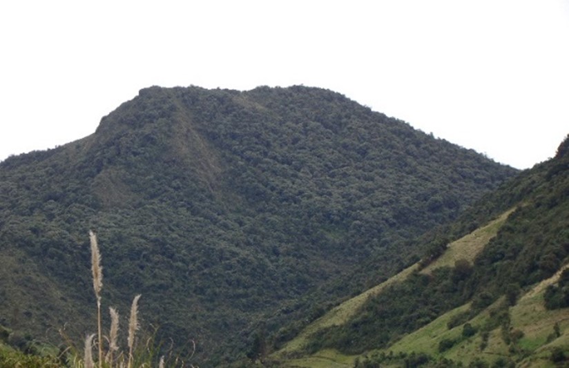
Shaushi Community, La Matriz Parish, Canton Quero, Province of Tungurahua.
technologies_4050 - เอกวาดอร์
ดูส่วนย่อย
ขยายทั้งหมด ย่อทั้งหมด1. ข้อมูลทั่วไป
1.2 รายละเอียดที่ติดต่อได้ของผู้รวบรวมและองค์กรที่เกี่ยวข้องในการประเมินและการจัดเตรียมทำเอกสารของเทคโนโลยี
วิทยากรหลัก
Galeas Raul
0986027084
raul12hc@gmail.com
CONDESAN
Calle Germán Alemán E12-123 y Carlos Arroyo del Río.
เอกวาดอร์
1.3 เงื่อนไขการใช้ข้อมูลที่ได้บันทึกผ่านทาง WOCAT
วันที่เก็บรวบรวมข้อมูล(ภาคสนาม) :
01/05/2017
ผู้รวบรวมและวิทยากรหลักยอมรับเงื่อนไขเกี่ยวกับการใช้ข้อมูลที่ถูกบันทึกผ่านทาง WOCAT:
ใช่
1.4 การเปิดเผยเรื่องความยั่งยืนของเทคโนโลยีที่ได้อธิบายไว้
เทคโนโลยีที่ได้อธิบายไว้นี้เป็นปัญหาของความเสื่อมโทรมโทรมของที่ดินหรือไม่ จึงไม่ได้รับการยอมรับว่าเป็นเทคโนโลยีเพื่อการจัดการที่ดินอย่างยั่งยืน:
ไม่ใช่
แสดงความคิดเห็น:
Land management practice is intended to preserve and restore soil conditions in the area of implementation.
2. การอธิบายลักษณะของเทคโนโลยี SLM
2.1 การอธิบายแบบสั้น ๆ ของเทคโนโลยี
คำจำกัดความของเทคโนโลยี:
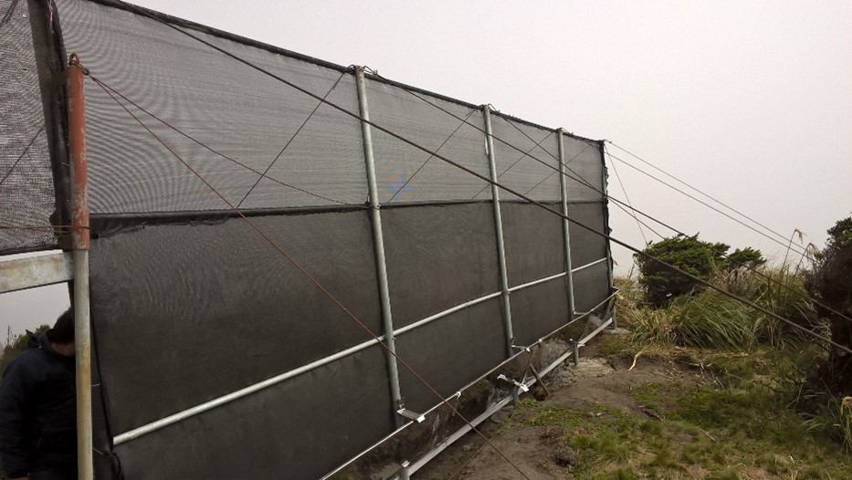
The practice consists in the installation of a water capture system, coming from the fog of the Cerro Shaushi zone, that allows to cover the need of water for domestic consumption of the inhabitants of the upper zone of the Community of Shaushi.
2.2 การอธิบายแบบละเอียดของเทคโนโลยี
คำอธิบาย:
The technology was applied in the Shaushi community in La Matriz parish, Canton Quero, province of Tungurahua. It consists in the installation of fog water capture system, declaration of a conservation and protection area, and participatory monitoring of water quality and quantity. Among the purposes of the technology is to make the population aware of the sustainable use of the territory and of the environmental services it provides, and to motivate them to take an active part in the conservation and protection of natural areas and water sources. Major activities are the periodic revision of the water capture system, repair and/or replacement of deteriorated or destroyed elements, and the continuous evaluation of the functionality of the practice, and continuous monitoring of water quality and quantity. The main benefit is the availability of water for human consumption in quantity and quality, conservation of natural areas, improvement of the relationship between human beings and nature, and to have hydrometeorological information for research purposes. The users of the practice are satisfied with its implementation and the benefits perceived so far, as they have been able to demonstrate the improvements described. As an opportunity for improvement, the need to deepen the knowledge about the páramo ecosystem and its benefits within the community is established. In addition, the initiative to implement this system in other geographical points is proposed, considering its benefits and the natural conditions of the area that make possible the availability of water for the community.
2.3 รูปภาพของเทคโนโลยี
อัลบั้มสื่อบันทึก
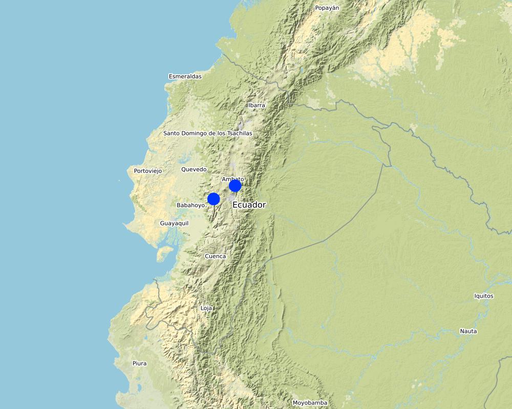
2.5 ประเทศภูมิภาค หรือสถานที่ตั้งที่เทคโนโลยีได้นำไปใช้และได้รับการครอบคลุมโดยการประเมินนี้
ประเทศ:
เอกวาดอร์
ภูมิภาค/รัฐ/จังหวัด:
Tungurahua
ข้อมูลจำเพาะเพิ่มเติมของสถานที่ตั้ง :
Shaushi
แสดงความคิดเห็น:
The reserve tank stores water from the fog water capture system and from the Quintina water source for domestic consumption in the Shuashi Community, with which it can supply the beneficiary population (30 families).
Map
×2.6 วันที่การดำเนินการ
ถ้าไม่รู้ปีที่แน่นอน ให้ระบุวันที่โดยประมาณ:
- น้อยกว่า 10 ปี (ไม่นานนี้)
2.7 คำแนะนำของเทคโนโลยี
ให้ระบุว่าเทคโนโลยีถูกแนะนำเข้ามาอย่างไร:
- ด้วยการริเริ่มของผู้ใช้ที่ดินเอง
- ในช่วงการทดลองหรือการทำวิจัย
- ทางโครงการหรือจากภายนอก
ความคิดเห็น (ประเภทของโครงการ เป็นต้น) :
This practice was established thanks to the management carried out by the "Mancomunidda del Frente Sur Occidental", "Fondo de Páramos de Tungurahua" and "the international organization Figth Against Poverty", with the financing of cooperating entities such as "Consorcio para el Desarrollo de la Ecorregión Andina" (CONDESAN) and the Ministry of the Environment, however, it was also a decision of the community of Shaushi, who assigned the area of implementation of the practice for conservation purposes.The reserve tank stores water from the fog water capture system and from the Quintina water source for domestic consumption in the Shuashi Community, with which it can supply the beneficiary population (30 families).
3. การจัดประเภทของเทคโนโลยี SLM
3.1 วัตถุประสงค์หลักของเทคโนโลยี
- ลด ป้องกัน ฟื้นฟู การเสื่อมโทรมของที่ดิน
- อนุรักษ์ระบบนิเวศน์
- ป้องกันพื้นที่ลุ่มน้ำ/บริเวณท้ายน้ำ โดยร่วมกับเทคโนโลยีอื่นๆ
- รักษาสภาพหรือปรับปรุงความหลากหลายทางชีวภาพ
- สร้างผลกระทบทางด้านสังคมที่เป็นประโยชน์
3.2 ประเภทของการใช้ที่ดินในปัจจุบันที่ได้นำเทคโนโลยีไปใช้

การใช้ที่ดินแบบผสมผสาน (รวมถึงวนเกษตร)
- การปลูกพืชร่วมกับปศุสัตว์ (Agro-pastoralism)
ผลิตภัณฑ์หลักหรือบริการ:
In the area of implementation of the practice outside the conservation area alternately develops short cycle crops mainly and livestock.

อื่น ๆ
ระบุ:
Paramo
ข้อสังเกต:
The practice was implemented in an area that preserves its natural conditions and is in recovery. This area was declared a conservation and protection area. In the area of implementation of the practice outside the conservation area alternately develops short cycle crops mainly and livestock.
ถ้าการใช้ที่ดินมีการเปลี่ยนแปลงเนื่องมาจากการนำเทคโนโลยีไปปฏิบัติใช้ ให้ระบุการใช้ที่ดินก่อนนำเทคโนโลยีไปปฏิบัติใช้:
The area where the practice was implemented was an area that was partially intervened with activities related to agriculture, grazing and forest plantations (native species and pine). Today the area is restricted under a conservation and protection agreement.
3.3 ข้อมูลเพิ่มเติมเกี่ยวกับการใช้ที่ดิน
การใช้น้ำของที่ดินที่มีการใช้เทคโนโลยีอยู่:
- น้ำฝนร่วมกับการชลประทาน
แสดงความคิดเห็น:
The area where the practice is applied does not require irrigation since it is currently under conservation agreement. The area of direct influence, outside the conservation area, in the Shaushi community uses rainwater and the Mocha - Quero Canal irrigation system as irrigation water.
จำนวนของฤดูเพาะปลูกต่อปี:
- 2
ระบุ:
In the cultivated area the crops (outside the conservation area) are rotated approximately after 4 to 6 months, depending on the product.
ความหนาแน่นของปศุสัตว์ (ถ้าเกี่ยวข้อง):
In the Shaushi Community, an average of 5-7 cattle per hectare is evident.
3.4 กลุ่ม SLM ที่ตรงกับเทคโนโลยีนี้
- การปิดล้อมพื้นที่ (หยุดการใช้ประโยชน์ สนับสนุนการฟื้นฟู)
- การเก็บเกี่ยวน้ำ
- การป้องกัน / การจัดการพื้นที่ชุ่มน้ำ
3.5 กระจายตัวของเทคโนโลยี
ระบุการกระจายตัวของเทคโนโลยี:
- ใช้ ณ จุดที่เฉพาะเจาะจงหรือเน้นไปยังบริเวณพื้นที่ขนาดเล็ก
แสดงความคิดเห็น:
The practice of applying a water capture system, although installed in specific points, is accompanied by the declaration of the implantation zone as a conservation and protection area.
3.6 มาตรการ SLM ที่ประกอบกันเป็นเทคโนโลยี

มาตรการอนุรักษ์ด้วยโครงสร้าง
- S7: การกักเก็บน้ำ/การส่งลำเลียง/อุปกรณ์การชลประทาน

มาตรการอนุรักษ์ด้วยการจัดการ
- M1: การเปลี่ยนรูปแบบของการใช้ประโยชน์ที่ดิน
มาตรการอื่น ๆ
แสดงความคิดเห็น:
Monitoring of water quality and quantity. The measures chosen correspond in the first case to the water capture system and in the second case refers to the declaration of the area of implantation of the practice as a conservation area.
3.7 รูปแบบหลักของการเสื่อมโทรมของที่ดินที่ได้รับการแก้ไขโดยเทคโนโลยี

การเสื่อมโทรมของดินทางด้านกายภาพ
- Pc (Compaction): การอัดแน่น

การเสื่อมโทรมของดินทางด้านชีวภาพ
- Bc (Reduction of vegetation cover): การลดลงของจำนวนพืชที่ปกคลุมดิน
- Bq (Quantity/biomass decline): การลดลงของปริมาณหรือมวลชีวภาพ
- Bl (Loss of soil life): การสูญเสียสิ่งมีชีวิตในดิน

การเสื่อมโทรมของน้ำ
- Ha (Aridification): การเกิดความแห้งแล้ง
- Hs (Change in quantity of surface water): การเปลี่ยนแปลงปริมาณของน้ำที่ผิวดิน
- Hp (Decline of surface water quality): การลดลงของคุณภาพน้ำที่ผิวดิน
- Hq (Decline of groundwater quality): การลดลงของคุณภาพน้ำบาดาล
- Hw (Reduction of the buffering capacity of wetland): การลดลงของความทนทานต่อการเปลี่ยนแปลง ของพื้นที่ชุ่มน้ำ
แสดงความคิดเห็น:
The practice avoids that in the area of conservation and sources of water they are intervened by the inhabitants of the Community of Shaushi and by the cattle of their property, with the development of sustainable activities like the capture of fog water that does not affect the availability of the resource. The water supply for domestic use for the inhabitants of Shaushi is currently provided by the Junta de Shaushi, San Vicente and Pueblo Viejo Drinking Water System. However, service coverage is partial; the inhabitants of the upper area of the Shaushi community do not have access to the water because the population has expanded over time to higher altitudes, making it impossible for the system to provide service for technical and infrastructural reasons. However, the population could not be fully supplied and there was a risk of contamination because there was no adequate infrastructure to distribute water for the two required uses.
3.8 การป้องกัน การลดลง หรือการฟื้นฟูความเสื่อมโทรมของที่ดิน
ระบุเป้าหมายของเทคโนโลยีกับความเสื่อมโทรมของที่ดิน:
- ป้องกันความเสื่อมโทรมของที่ดิน
- ลดความเสื่อมโทรมของดิน
แสดงความคิดเห็น:
The practice also includes the sustainable management of soil and territory with the capture of water from the fog, the declaration of this area as an area of conservation and protection that will prevent deep soil degradation.
4. ข้อมูลจำเพาะด้านเทคนิค กิจกรรมการนำไปปฏิบัติใช้ ปัจจัยนำเข้า และค่าใช้จ่าย
4.1 แบบแปลนทางเทคนิคของเทคโนโลยี
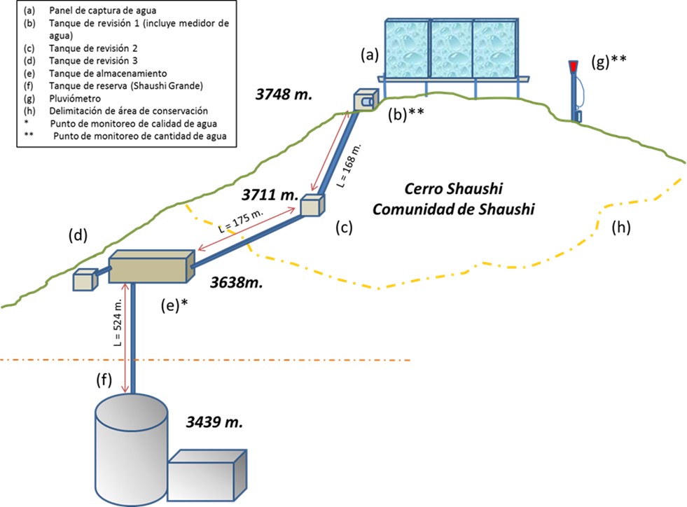
ผู้เขียน:
General diagram of the practice
วันที่:
01/05/2017
4.2 ข้อมูลจำเพาะด้านเทคนิคและการอธิบายแบบแปลนทางเทคนิค
Dimensions
Capture Panel Review and Breakthrough Tanks
Height = 4 m. length = 1.0 m.
Length = 10 m. width = 1.0 m.
depth = 1.0 m.
Driving line storage tank
Length = 343 m. length = 3 m.
Diameter = 32 mm. width = 2 m.
depth = 2 m.
Tank capacity Overhaul and breaker tanks
Volume = 1 m3
Storage tank
Volume = 12 m3
Slope angle: Mostly the terrain of the practice implantation zone is 30-40%.
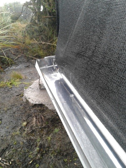
Construction material used: Galvanized steel pipes, zaran mesh, cement, stone, sand and gravel, PVC pipes, fittings (keys, elbows, valves, etc.), iron stakes for supports, tensioners, tol lids for tanks.
Area 137 ha, owned by Shaushi Community
Altitude range approx. 3400-3700 m
Slope range 30 - 40 %.
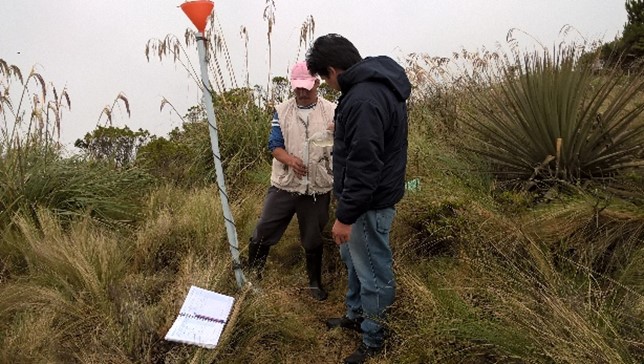
Parameters considered: pH, conductivity, total dissolved solids, water temperature, precipitation and flow.
Monitoring points water storage tank.
1) Precipitation: Nearby of the water capture screen (neblinometer).
2) Flow: to one side of the water capture panel (neblinometer).
Monthly frequency
1) Precipitation: Weekly
2) Flow: Weekly
Materials and/or equipment used
1) pH, conductivity, total dissolved solids: Multiparametric equipment.
2) Water temperature: Thermometer and/or multiparametric
equipment
1) Precipitation: Totalizer rain gauge (wooden stake, plastic bottle, mangueta, measuring probe.
2) Flow: Micrometer (water meter).
4.3 ข้อมูลทั่วไปเกี่ยวกับการคำนวณปัจจัยนำเข้าและค่าใช้จ่าย
ให้ระบุว่าค่าใช้จ่ายและปัจจัยนำเข้าได้รับการคำนวณอย่างไร:
- ต่อพื้นที่ที่ใช้เทคโนโลยี
ระบุสกุลเงินที่ใช้คำนวณค่าใช้จ่าย:
- ดอลลาร์สหรัฐ
ระบุค่าเฉลี่ยของค่าจ้างในการจ้างแรงงานต่อวัน:
10-20
4.4 กิจกรรมเพื่อการจัดตั้ง
| กิจกรรม | ประเภทของมาตรการ | ช่วงเวลาดำเนินการ | |
|---|---|---|---|
| 1. | Installation of fog water capture system | ด้วยโครงสร้าง | Only once the site has been identified. |
| 2. | Declaration of conservation and protection area in the area of implementation of the practice | ด้วยการจัดการ | Only once the area of interest has been identified. |
| 3. | Participatory monitoring of water quality and quantity. | มาตรการอื่น ๆ | Amount of water: weekly Water quality: monthly |
แสดงความคิดเห็น:
The most relevant activities carried out for the implementation of the practice are considered. In the following paragraphs the declaration activity of the conservation area will not be considered due to the fact that it is an inter-institutional management activity only.
4.5 ค่าใช้จ่ายของปัจจัยนำเข้าที่จำเป็นสำหรับการจัดตั้ง
ถ้าเป็นไปได้ให้แจกแจงรายละเอียดต้นทุนการบำรุงรักษาตามตารางข้างล่างดังต่อไปนี้ ให้ระบุลงไปถึงปัจจัยนำเข้าและค่าใช้จ่ายต่อปัจจัยนำเข้า ถ้าไม่สามารถแจกแจงรายละเอียดต้นทุนได้ ให้ทำการประมาณค่าใช้จ่ายทั้งหมดในการบำรุงรักษาเทคโนโลยี:
33238.86
| ปัจจัยนำเข้า | หน่วย | ปริมาณ | ค่าใช้จ่ายต่อหน่วย | ค่าใช้จ่ายทั้งหมดต่อปัจจัยนำเข้า | %ของค่าใช้จ่ายที่ก่อให้เกิดขึ้นโดยผู้ใช้ที่ดิน | |
|---|---|---|---|---|---|---|
| แรงงาน | Construction and installation of the elements of the water capture system. Skilled and unskilled labor. | 1 | 1.0 | 26176.33 | 26176.33 | 3.4 |
| แรงงาน | Water quality and quantity monitoring (measurements) | 1 | 1.0 | 500.0 | 500.0 | 100.0 |
| อุปกรณ์ | Miscellaneous materials for the construction and installation of the water harvesting system | 1 | 1.0 | 2012.53 | 2012.53 | |
| อุปกรณ์ | Materials and equipment for water quality and quantity sampling and measurements | 1 | 1.0 | 4550.0 | 4550.0 | |
| ค่าใช้จ่ายทั้งหมดของการจัดตั้งเทคโนโลยี | 33238.86 | |||||
ถ้าผู้ใช้ที่ดินรับภาระน้อยกว่า 100% ของค่าใช้จ่าย ให้ระบุว่าใครเป็นผู้รับผิดชอบส่วนที่เหลือ:
The cooperating entities for the application of the practice were: CONDESAN, Ministry of Environment MAE (Project GIDACC), FMPLPT, Autonomous Decentralized Municipal Government of the canton Santiago Quero and the Commonwealth of FSO.
แสดงความคิดเห็น:
The costs were estimated on the basis of the information available from the cooperating entities.
4.6 การบำรุงรักษาสภาพหรือกิจกรรมที่เกิดขึ้นเป็นประจำ
| กิจกรรม | ประเภทของมาตรการ | ช่วงระยะเวลา/ความถี่ | |
|---|---|---|---|
| 1. | Review of fog water capture system and additional elements for monitoring. | มาตรการอื่น ๆ | weekly |
| 2. | Repair and/or replacement of deteriorated or damaged elements. | ด้วยโครงสร้าง | when necessary |
4.7 ค่าใช้จ่ายของปัจจัยนำเข้าและกิจกรรมที่เกิดขึ้นเป็นประจำที่ต้องการการบำรุงรักษา (ต่อปี)
ถ้าเป็นไปได้ให้แจกแจงรายละเอียดต้นทุนการบำรุงรักษาตารางข้างล่างดังต่อไปนี้ ให้ชี้ระบุลงไปถึงปัจจัยการผลิตและค่าใช้จ่ายต่อปัจจัยการผลิต ถ้าคุณไม่สามารถแจกแจงรายละเอียดต้นทุนได้ ให้ทำการประมาณค่าใช้จ่ายทั้งหมดในการบำรุงรักษา:
4900.0
ถ้าผู้ใช้ที่ดินรับภาระน้อยกว่า 100% ของค่าใช้จ่าย ให้ระบุว่าใครเป็นผู้รับผิดชอบส่วนที่เหลือ:
The costs so far have been assumed by the Technical Unit of the Commonwealth of Southern Western Front.
แสดงความคิดเห็น:
It is proposed that an agreement be made with the community to establish responsibilities for the maintenance of the practice.
4.8 ปัจจัยสำคัญที่สุดที่มีผลกระทบต่อค่าใช้จ่าย
ปัจจัยสำคัญที่สุดที่มีผลกระทบต่อค่าใช้จ่ายต่างๆ:
According to the perception of the beneficiaries, the most important factor that can affect the system and therefore the costs, are the environmental conditions of the area, especially the presence of strong winds that could mainly affect the water capture panel fog.
5. สิ่งแวดล้อมทางธรรมชาติและของมนุษย์
5.1 ภูมิอากาศ
ฝนประจำปี
- < 250 ม.ม.
- 251-500 ม.ม.
- 501-750 ม.ม.
- 751-1,000 ม.ม.
- 1,001-1,500 ม.ม.
- 1,501-2,000 ม.ม.
- 2,001-3,000 ม.ม.
- 3,001-4,000 ม.ม.
- > 4,000 ม.ม.
ระบุปริมาณน้ำฝนเฉลี่ยรายปี (ถ้ารู้) :หน่วย ม.ม.
615.00
ข้อมูลจำเพาะ/ความคิดเห็นเรื่องปริมาณน้ำฝน:
In the Inter-Andean region the Rainy Period presents a bimodal distribution, presenting a Secondary Rainy Period during the months of September to November and the Main Rainy Period during the months of February to May.
ระบุชื่อของสถานีตรวดวัดอากาศที่ใช้อ้างอิงคือ:
Querochaca and Huambalo from INAMHI
เขตภูมิอากาศเกษตร
- กึ่งชุ่มชื้น
The agroclimatic zone was determined based on the information of the biophysical characterization provided in the Diagnosis of the Quero Canton in the Cubillo Paulina Grade Thesis.
5.2 สภาพภูมิประเทศ
ค่าเฉลี่ยความลาดชัน:
- ราบเรียบ (0-2%)
- ลาดที่ไม่ชัน (3-5%)
- ปานกลาง (6-10%)
- เป็นลูกคลื่น (11-15%)
- เป็นเนิน (16-30%)
- ชัน (31-60%)
- ชันมาก (>60%)
ธรณีสัณฐาน:
- ที่ราบสูง/ที่ราบ
- สันเขา
- ไหล่เขา
- ไหล่เนินเขา
- ตีนเนิน
- หุบเขา
ระดับความสูง:
- 0-100 เมตร
- 101-500 เมตร
- 501-1,000 เมตร
- 1,001-1,500 เมตร
- 1,501-2,000 เมตร
- 2,001-2,500 เมตร
- 2,501-3,000 เมตร
- 3,001-4,000 เมตร
- > 4,000 เมตร
ให้ระบุถ้าเทคโนโลยีได้ถูกนำไปใช้:
- บริเวณสันเขา (convex situations)
ความคิดเห็นและข้อมูลจำเพาะเพิ่มเติมเรื่องสภาพภูมิประเทศ:
The actions carried out as part of the practice are located in an area with rugged topography, mostly in convex areas.
5.3 ดิน
ค่าเฉลี่ยความลึกของดิน:
- ตื้นมาก (0-20 ซ.ม.)
- ตื้น (21-50 ซ.ม.)
- ลึกปานกลาง (51-80 ซ.ม.)
- ลึก (81-120 ซ.ม.)
- ลึกมาก (>120 ซ.ม.)
เนื้อดิน (ดินชั้นบน):
- หยาบ/เบา (ดินทราย)
- ละเอียด/หนัก (ดินเหนียว)
เนื้อดินล่าง (> 20 ซ.ม.ต่ำจากผิวดิน):
- หยาบ/เบา (ดินทราย)
- ละเอียด/หนัก (ดินเหนียว)
อินทรียวัตถุในดิน:
- สูง (>3%)
(ถ้ามี) ให้แนบคำอธิบายเรื่องดินแบบเต็มหรือระบุข้อมูลที่มีอยู่ เช่น ชนิดของดิน ค่า pH ของดินหรือความเป็นกรดของดิน ความสามารถในการแลกเปลี่ยนประจุบวก ไนโตรเจน ความเค็ม เป็นต้น:
The soils of Quero are volcanic and are mainly differentiated by the parental material: there are soils formed in recent volcanic ash (Andosoles: northern and central soils) and soils formed in meteorized metamorphic rock (Inceptisoles: southern soils).
Specifically they are evidenced from Udic Eutrandepts soils (Hv) and their characteristics are: isothermal black; francs with fine to medium sand with clear presence of silt; 4 to 5% organic matter from 0 to 20 cm; deep (1m); friable; well drained; water retention from 10 to 20%; neutral pH; medium natural fertility.
In this area, also have an Entic Distrandepts soils (Dny) and their characteristics are: with content of coarse pumice sand in more than 35% over the whole profile. Moderate to high water retention capacity, 50 to 80%; very black; loamy pseudo-silt textures; deep; well drained.
5.4 ความเป็นประโยชน์และคุณภาพของน้ำ
ระดับน้ำใต้ดิน:
ที่ผิวดิน
น้ำไหลบ่าที่ผิวดิน:
ปานกลาง
คุณภาพน้ำ (ที่ยังไม่ได้บำบัด):
เป็นน้ำเพื่อการดื่มที่ไม่ดี (จำเป็นต้องได้รับการบำบัด)
ความเค็มของน้ำเป็นปัญหาหรือไม่:
ไม่ใช่
กำลังเกิดน้ำท่วมในพื้นที่หรือไม่:
ไม่ใช่
ความคิดเห็นและข้อมูลจำเพาะเพิ่มเติมเรื่องคุณภาพและปริมาณน้ำ:
The monitoring of the captured water is currently being carried out, with the result that up to now the water is of acceptable quality. There is no specific groundwater information available for the area. It is estimated that the soil is not very permeable and the aquifers are very localized (INAMHI, 2015).
5.5 ความหลากหลายทางชีวภาพ
ความหลากหลายทางชนิดพันธุ์:
- ปานกลาง
ความหลากหลายของแหล่งที่อยู่:
- ปานกลาง
ความคิดเห็นและข้อมูลจำเพาะเพิ่มเติมของความหลากหลายทางชีวภาพ:
In order to determine the diversity of the practice area, the following data are considered: The Sierra del Ecuador region is characterized for being crossed by knots and high mountain chains (with their moors), which have their own biodiversity and diversity of environments and habitats, due to isolation. The ecosystem maintains shrub and herbaceous vegetation (Mena and Medina, 2001). The moor in Quero canton has an evident fragility, due to the constant expansion of the agricultural frontier, overgrazing, burning of grasslands, deforestation, etc., so that the area destined for conservation and protection in the Community of Shaushi is only a remnant of this ecosystem (GAD Quero, 2014).
5.6 ลักษณะของผู้ใช้ที่ดินที่นำเทคโนโลยีไปปฏิบัติใช้
อยู่กับที่หรือเร่ร่อน:
- อยู่กับที่
แนวทางการตลาดของระบบการผลิต:
- ผสม (การเลี้ยงชีพ/ทำการค้า)
รายได้ที่มาจากนอกฟาร์ม:
- < 10% ของรายได้ทั้งหมด
เป็นรายบุคคล/ครัวเรือน:
- เป็นรายบุคคล/ครัวเรือน
- กลุ่ม/ชุมชน
ระดับของการใช้เครื่องจักรกล:
- งานที่ใช้แรงกาย
- การใช้เครื่องจักรหรือเครื่องยนต์
เพศ:
- หญิง
- ชาย
อายุของผู้ใช้ที่ดิน:
- วัยกลางคน
ระบุลักษณะอื่นๆที่เกี่ยวข้องของผู้ใช้ที่ดิน:
In order to determine the relative level of poverty, data are taken from the 2010 National Census conducted by INEC, which indicates that the percentage of poor due to unsatisfied basic needs in Quero canton is 84.5% (GAD Quero, 2014; SNI, 2017). The components or dimensions: (i) quality of housing, (ii) overcrowding, (iii) access to basic services, (iv) access to education and (v) economic capacity (INEC, 2016).
5.7 พื้นที่เฉลี่ยของที่ดินที่เป็นเจ้าของหรือเช่าโดยผู้ใช้ที่ดินที่นำเทคโนโลยีไปปฏิบัติใช้
- < 0.5 เฮกตาร์
- 0.5-1 เฮกตาร์
- 1-2 เฮกตาร์
- 2-5 เฮกตาร์
- 5-15 เฮกตาร์
- 15-50 เฮกตาร์
- 50-100 เฮกตาร์
- 100-500 เฮกตาร์
- 500-1,000 เฮกตาร์
- 1,000-10,000 เฮกตาร์
- >10,000 เฮกตาร์
พิจารณาว่าเป็นขนาดเล็ก กลาง หรือขนาดใหญ่ (ซึ่งอ้างอิงถึงบริบทระดับท้องถิ่น):
- ขนาดเล็ก
แสดงความคิดเห็น:
The inhabitants of the Shaushi Community have an average area of less than 3 ha.
5.8 กรรมสิทธิ์ในที่ดิน สิทธิในการใช้ที่ดินและสิทธิในการใช้น้ำ
- mixed
- mixed
สิทธิในการใช้น้ำ:
- เกี่ยวกับชุมชน (ถูกจัดระเบียบ)
แสดงความคิดเห็น:
In the area of direct influence (Shaushi Community) the lands are individual property except for the area destined for conservation and protection which is communal.
5.9 การเข้าถึงบริการและโครงสร้างพื้นฐาน
สุขภาพ:
- จน
- ปานกลาง
- ดี
การศึกษา:
- จน
- ปานกลาง
- ดี
ความช่วยเหลือทางด้านเทคนิค:
- จน
- ปานกลาง
- ดี
การจ้างงาน (เช่น ภายนอกฟาร์ม):
- จน
- ปานกลาง
- ดี
ตลาด:
- จน
- ปานกลาง
- ดี
พลังงาน:
- จน
- ปานกลาง
- ดี
ถนนและการขนส่ง:
- จน
- ปานกลาง
- ดี
น้ำดื่มและการสุขาภิบาล:
- จน
- ปานกลาง
- ดี
บริการด้านการเงิน:
- จน
- ปานกลาง
- ดี
6. ผลกระทบและสรุปคำบอกกล่าว
6.1 ผลกระทบในพื้นที่ดำเนินการ (On-site) จากการใช้เทคโนโลยี
ผลกระทบทางด้านเศรษฐกิจและสังคม
ความเป็นประโยชน์และคุณภาพของน้ำ
การมีน้ำดื่มไว้ให้ใช้
คุณภาพน้ำดื่ม
ผลกระทบด้านสังคมวัฒนธรรมอื่น ๆ
สถานการณ์ด้านสุขภาพ
การใช้ที่ดิน / สิทธิในการใช้น้ำ
สถาบันของชุมชน
SLM หรือความรู้เรื่องความเสื่อมโทรมของที่ดิน
การบรรเทาความขัดแย้ง
ผลกระทบด้านนิเวศวิทยา
วัฐจักรน้ำหรือน้ำบ่า
ปริมาณน้ำ
คุณภาพน้ำ
การเก็บเกี่ยวหรือการกักเก็บน้ำ
ดิน
ความชื้นในดิน
สิ่งปกคลุมดิน
การอัดแน่นของดิน
ความหลากหลายทางชีวภาพของพืชและสัตว์
การปกคลุมด้วยพืช
ความหลากหลายทางชีวภาพของพืช
ลดความเสี่ยงของภัยพิบัติ
ผลกระทบจากภัยแล้ง
การปล่อยคาร์บอนและก๊าซเรือนกระจก
ภูมิอากาศจุลภาค
6.2 ผลกระทบนอกพื้นที่ดำเนินการ (Off-site) จากการใช้เทคโนโลยี
น้ำที่ใช้ประโยชน์ได้
การไหลของน้ำคงที่และสม่ำเสมอในช่วงฤดูแล้ง
ความคิดเห็นเกี่ยวกับการประเมินผลกระทบ:
Impacts that have been classified as insignificant are thus valued because they are impacts expected by the practices considering their scope, but which have not been measured or perceived by the population as opposed to the impacts valued at the time of analysis.
6.3 การเผชิญและความตอบสนองของเทคโนโลยีต่อการเปลี่ยนแปลงสภาพภูมิอากาศที่ค่อยเป็นค่อยไป และสภาพรุนแรงของภูมิอากาศ / ภัยพิบัติ (ที่รับรู้ได้โดยผู้ใช้ที่ดิน)
การเปลี่ยนแปลงสภาพภูมิอากาศที่ค่อยเป็นค่อยไป
การเปลี่ยนแปลงสภาพภูมิอากาศที่ค่อยเป็นค่อยไป
| ฤดู | ประเภทของการเปลี่ยนแปลงสภาพภูมิอากาศที่ค่อยเป็นค่อยไป และสภาพรุนแรงของภูมิอากาศ | เทคโนโลยีมีวิธีการรับมืออย่างไร | |
|---|---|---|---|
| อุณหภูมิประจำปี | เพิ่มขึ้น | ไม่ทราบ | |
| ฝนประจำปี | เพิ่มขึ้น | ดี | |
| การเปลี่ยนแปลงสภาพภูมิอากาศที่ค่อยเป็นค่อยไปอื่น ๆ | Loss of seasonality | เพิ่มขึ้น | ไม่ทราบ |
สภาพรุนแรงของภูมิอากาศ (ภัยพิบัติ)
ภัยพิบัติจากสภาพภูมิอากาศ
| เทคโนโลยีมีวิธีการรับมืออย่างไร | |
|---|---|
| คลื่นความหนาว | ดี |
6.4 การวิเคราะห์ค่าใช้จ่ายและผลประโยชน์ที่ได้รับ
ผลประโยชน์ที่ได้รับเปรียบเทียบกับค่าใช้จ่ายในการจัดตั้งเป็นอย่างไร (จากมุมมองของผู้ใช้ที่ดิน)
ผลตอบแทนระยะสั้น:
ด้านบวกอย่างมาก
ผลตอบแทนระยะยาว:
ด้านบวกอย่างมาก
ผลประโยชน์ที่ได้รับเปรียบเทียบกับค่าใช้จ่ายในการบำรุงรักษาหรือต้นทุนที่เกิดขึ้นซ้ำอีก เป็นอย่างไร (จากมุมมองของผู้ใช้ที่ดิน)
ผลตอบแทนระยะสั้น:
ด้านบวกอย่างมาก
ผลตอบแทนระยะยาว:
ด้านบวกอย่างมาก
แสดงความคิดเห็น:
The most plausible benefit for the population of the Shaushi Community is the availability of water for human consumption for the inhabitants who did not have it, so the comparison in terms of costs is assumed in the case of not having the practice, which would represent carrying out a project to transport the water from another geographical point, which would be more costly. On the other hand, the perceived benefits also include environmental and health benefits, which are not quantified economically, thanks to the conservation of the area of implantation of the practice.
6.5 การปรับตัวของเทคโนโลยี
- มากกว่า 50%
ถ้ามีข้อมูลให้บอกปริมาณด้วย (จำนวนของครัวเรือนหรือครอบคลุมพื้นที่):
23
จากทั้งหมดที่ได้รับเทคโนโลยีเข้ามามีจำนวนเท่าใดที่ทำแบบทันที โดยไม่ได้รับการจูงใจด้านวัสดุหรือการเงินใด ๆ:
- 90-100%
แสดงความคิดเห็น:
The decision to adopt the practice was made within the Shaushi Community (beneficiaries) for those who did not have the service, where the villagers understood the need to allocate the area for conservation and protection considering the benefits it provides, and the advantage of having a system that would provide water for the consumption of the villagers who did not have the resource.
6.6 การปรับตัว
เทคโนโลยีได้รับการปรับเปลี่ยนเมื่อเร็วๆนี้ เพื่อให้ปรับตัวเข้ากับสภาพที่กำลังเปลี่ยนแปลงหรือไม่:
ใช่
อื่น ๆ (ระบุ):
Climatic conditions, terrain and structure of the water capture panel.
ให้ระบุการปรับตัวของเทคโนโลยี (การออกแบบ วัสดุหรือชนิดพันธุ์ เป็นต้น):
The dimensions of the excavations were reviewed to place the holders and turnbuckles, considering the slope and shape of the relief so that the system is stable.
6.7 จุดแข็ง / ข้อได้เปรียบ / โอกาสของเทคโนโลยี
| จุดแข็ง / ข้อได้เปรียบ / โอกาสในทัศนคติของผู้ใช้ที่ดิน |
|---|
| The commitment of the inhabitants of the community to preserve the environment and specifically the protection area that provides them with water in quantity and quality. |
| The water capture system provides them with direct benefits in terms of the availability of drinking water for this zone. |
| Participatory monitoring is beneficial because it allows them to control the quality and quantity of water that the system can provide. |
| จุดแข็ง / ข้อได้เปรียบ / โอกาสในทัศนคติของผู้รวบรวมหรือวิทยากรหลัก |
|---|
| Plant restoration trials can be carried out to improve knowledge in these ecosystems, which were intervened and which are subsequently destined for conservation. |
| It is possible to investigate how a natural ecosystem in conservation interacts with the areas in its surroundings that are highly intervened and how it could affect it. |
| Decrease in dependence on other water sources for sustainable management of soil and other resources. |
| Investigations can be carried out based on the measurements and analysis of water quantity and quality carried out and to be carried out. Analysis of soil moisture and other elements may be included. |
| Implementation of other practices for research and/or sustainable use of soil and water, with high community participation. |
| The community can be strengthened with respect to issues related to the conservation of these ecosystems and the services they provide, so that they can be properly managed and managed. |
6.8 จุดอ่อน / ข้อเสียเปรียบ / ความเสี่ยงของเทคโนโลยีและวิธีการแก้ไข
| จุดอ่อน / ข้อเสียเปรียบ / ความเสี่ยงในทัศนคติของผู้ใช้ที่ดิน | มีวิธีการแก้ไขได้อย่างไร |
|---|---|
| Some users do not respect the rules established for the management of the area destined for conservation, and residues from past activities are still observed. | Sanctions can be established for the presence of any improper action, however, in parallel with the practice, training should continue to involve users more in the review and maintenance activities, in order to achieve a better result. |
| The environmental conditions of the site, especially the strength of the wind in the area. | It is being continuously reviewed to detect any impact on the system, especially on the water capture panel, which could break or become dislocated. |
| In the water capture panel fog, due to the height of the water collection gutter, it splashes in heavy rain events allowing soil to enter into the system from the ground. The same factor when the system becomes saturated or plugged the water overflows into the gutter, so collection is sometimes inefficient. | The functionality of the system is being reviewed, if necessary any modifications will be made in coordination with the community. |
| จุดอ่อน / ข้อเสียเปรียบ / ความเสี่ยงในทัศนคติของผู้รวบรวมหรือวิทยากรหลัก | มีวิธีการแก้ไขได้อย่างไร |
|---|---|
| Lack of a preventive and corrective maintenance plan to maintain optimal conditions. | It is neccesary to include a preventive and corrective maintenance plan that should be agreed between the technical area of the cooperating entities and with the users of the communities for its application. |
| The practice of permanent monitoring is insufficient, because data collection is minimal. | The cooperating entities and community authorities can establish a monitoring action plan that covers several lines, including infrastructure such as monitoring for research purposes. |
7. การอ้างอิงและการเชื่อมต่อ
7.1 วิธีการและแหล่งข้อมูล
- ไปเยี่ยมชมภาคสนาม การสำรวจพื้นที่ภาคสนาม
Land users and technicians from cooperating entities were interviewed.
- การสัมภาษณ์กับผู้ใช้ที่ดิน
3 land users, one of them is the President of the Junta de Agua Potable.
- การสัมภาษณ์ผู้เชี่ยวชาญด้าน SLM หรือผู้ชำนาญ
Three technicians from the cooperating entities: Mancomunidad FSO and Fondo de Páramos.
- การเก็บรวบรวมมาจากรายงานและเอกสารที่มีอยู่
The documents used include technical reports prepared by the technicians of the Fondo de Páramos, reports and terms of reference prepared by the Technical Unit of the FSO.
7.2 การอ้างอิงถึงสิ่งตีพิมพ์
หัวข้อ, ผู้เขียน, ปี, หมายเลข ISBN:
"Los páramos del Ecuador". Mena Vásconez Patricio y Medina Galo. 2001. Abya-Yala / Proyecto Páramo, Quito.
ชื่อเรื่อง ผู้เขียน ปี ISBN:
Available for free online: https://www.portalces.org/sites/default/files/references/044_Mena%20et%20al.%20(Eds.).%20%202001.Paramos%20Ecuador%20PORTADA%2B_%2BHOJA%2BTECNICA%2BY%2BPRESENTACION.pdf
หัวข้อ, ผู้เขียน, ปี, หมายเลข ISBN:
"La biodiversidad en el Ecuador". Bravo Velásquez Elizabeth. 2014. Universidad Politécnica Salesiana. Cuenca-Ecuador.
ชื่อเรื่อง ผู้เขียน ปี ISBN:
Available for free online: https://dspace.ups.edu.ec/handle/123456789/6788
หัวข้อ, ผู้เขียน, ปี, หมายเลข ISBN:
Actualización Plan de Desarrollo y Ordenamiento Territorial-Quero 2014. Gobierno Autónomo Descentralizado Municipal del Cantón Quero. 2014.
ชื่อเรื่อง ผู้เขียน ปี ISBN:
Available for free online: http://app.sni.gob.ec/sni-link/sni/PORTAL_SNI/data_sigad_plus/sigadplusdiagnostico/1860000800001_PDYOT%20QUERO%20CONSOLIDADO_19-04-2015_20-19-44.pdf
หัวข้อ, ผู้เขียน, ปี, หมายเลข ISBN:
Informe de implementación de un sistema de captura de agua niebla en la comunidad de Shaushi, en el cantón Quero. Guevara Rocío. 2017. Fondo de Manejo de Páramos y Lucha contra la pobreza Tungurahua.
ชื่อเรื่อง ผู้เขียน ปี ISBN:
In the archives of the Tungurahua Wetland Fund and Fight against Poverty in the GAD of the province of Tungurahua.
หัวข้อ, ผู้เขียน, ปี, หมายเลข ISBN:
Informe y base de datos de Shaushi y Llimpes, que incluye la línea base llena y estructurada de acuerdo a los lineamientos de CONDESAN. Calle Juan. 2017. CONDESAN.
ชื่อเรื่อง ผู้เขียน ปี ISBN:
In the archives of the Consortium for Sustainable Development of the Andean Ecoregion CONDESAN.
หัวข้อ, ผู้เขียน, ปี, หมายเลข ISBN:
Informe final de “Construcción de un sistema de captura de agua niebla en la comunidad de Shaushi, cantón Quero”. Mancomunidad de GADs municipales “Frente Sur Occidental” de la provincia de Tungurahua. 2017.
ชื่อเรื่อง ผู้เขียน ปี ISBN:
In the archives of the Technical Unit of the Mancomunidad de GADs municipales "Frente Sur Occidental" of the province of Tungurahua.
หัวข้อ, ผู้เขียน, ปี, หมายเลข ISBN:
Manual de monitoreo hídrico participativo. Calles Juan. 2016. CONDESAN.
ชื่อเรื่อง ผู้เขียน ปี ISBN:
In the archives of the Consortium for Sustainable Development of the Andean Ecoregion CONDESAN.
หัวข้อ, ผู้เขียน, ปี, หมายเลข ISBN:
Reporte de Pobreza y Desigualdad. Diciembre 2016. INEC. Dirección responsable de la información estadística y contenidos: Dirección de Innovación en Métricas y Metodologías.
ชื่อเรื่อง ผู้เขียน ปี ISBN:
Available for free online: https://www.ecuadorencifras.gob.ec/documentos/web-inec/POBREZA/2016/Diciembre_2016/Reporte%20pobreza%20y%20desigualdad-dic16.pdf
หัวข้อ, ผู้เขียน, ปี, หมายเลข ISBN:
Ubicación del Nuevo Relleno Sanitario en base a criterios ambientales, socioeconómicos y técnicos, y propuesta de Plan de Reciclaje en la ciudad de Quero, Cantón Quero Provincia del Tungurahua. Cubillo Paulina. 2005. Escuela Politécnica del Ejército.
ชื่อเรื่อง ผู้เขียน ปี ISBN:
Available for free online: http://repositorio.espe.edu.ec/xmlui/handle/21000/722
หัวข้อ, ผู้เขียน, ปี, หมายเลข ISBN:
Introducción a la Hidrogeología del Ecuador (Segunda Versión). Burbano Napoléon, Becerra Simón, Pasquel Efrén. 2014. INAMHI
ชื่อเรื่อง ผู้เขียน ปี ISBN:
Available for free online: http://www.serviciometeorologico.gob.ec/Publicaciones/Hidrologia/HIDROGEOLOGIA_2%20EDICION_2014.pdf
7.3 เชื่อมโยงกับข้อมูลที่มีอยู่บนออนไลน์
ชื่อเรื่องหรือคำอธิบาย:
Anuarios meteorológicos del Instituto Nacional de Meteorología e Hidrología INAMHI.
URL:
http://www.forosecuador.ec/forum/ecuador/educaci%C3%B3n-y-ciencia/35393-inamhi-anuarios-metereol%C3%B3gicos-en-pdf
ชื่อเรื่องหรือคำอธิบาย:
Boletín Anual del Instituto Nacional de Meteorología e Hidrología INAMHI.
URL:
http://www.serviciometeorologico.gob.ec/boletin-anual/
ชื่อเรื่องหรือคำอธิบาย:
Indicadores de pobreza del INEC 2010. Sistema Nacional de Información.
URL:
http://indestadistica.sni.gob.ec/QvAJAXZfc/opendoc.htm?document=SNI.qvw&host=QVS@kukuri&anonymous=truehttp://indestadistica.sni.gob.ec/QvAJAXZfc/opendoc.htm?document=SNI.qvw&host=QVS@kukuri&anonymous=true&bookmark=Document/BM27
ชื่อเรื่องหรือคำอธิบาย:
Sistema Nacional de Información. Página de la Secretaría Nacional de Planificación y Desarrollo del Ecuador
URL:
http://app.sni.gob.ec/web/menu/
ลิงก์และโมดูล
ขยายทั้งหมด ย่อทั้งหมดลิงก์
ไม่มีลิงก์
โมดูล
ไม่มีโมดูล