Stone Check Walls and Check Dams for Soil and Water Conservation [ប្រទេសឥណ្ឌា]
- ការបង្កើត៖
- បច្ចុប្បន្នភាព
- អ្នកចងក្រង៖ Jaclyn Bandy
- អ្នកកែសម្រួល៖ –
- អ្នកត្រួតពិនិត្យ Hanspeter Liniger
technologies_5210 - ប្រទេសឥណ្ឌា
ពិនិត្យមើលគ្រប់ផ្នែក
ពង្រីកមើលទាំងអស់ បង្រួមទាំងអស់1. ព័ត៌មានទូទៅ
1.2 ព័ត៌មានលម្អិតពីបុគ្គលសំខាន់ៗ និងស្ថាប័នដែលចូលរួមក្នុងការវាយតម្លៃ និងចងក្រងឯកសារនៃបច្ចេកទេស
បុគ្គលសំខាន់ម្នាក់ (ច្រើននាក់)
អ្នកប្រើប្រាស់ដី:
Jagdamba Joshi
Nakina Village
ប្រទេសឥណ្ឌា
ឈ្មោះគម្រោងដែលបានចងក្រងឯកសារ/ វាយតម្លៃលើបច្ចេកទេស (បើទាក់ទង)
Onsite and Offsite Benefits of SLMឈ្មោះអង្គភាពមួយ (ច្រើន) ដែលបានចងក្រងឯកសារ/ វាយតម្លៃបច្ចេកទេស (បើទាក់ទង)
ICIMOD International Centre for Integrated Mountain Development (ICIMOD) - ប្រទេសនេប៉ាល់ឈ្មោះអង្គភាពមួយ (ច្រើន) ដែលបានចងក្រងឯកសារ/ វាយតម្លៃបច្ចេកទេស (បើទាក់ទង)
G.B. Pant Institute of Himalayan Einvironment & Development (G.B. Pant Institute of Himalayan Einvironment & Development) - ប្រទេសឥណ្ឌា1.3 លក្ខខណ្ឌទាក់ទងទៅនឹងការប្រើប្រាស់ទិន្នន័យដែលបានចងក្រងតាមរយៈ វ៉ូខេត
អ្នកចងក្រង និង(បុគ្គលសំខាន់ៗ)យល់ព្រមទទួលយកនូវលក្ខខណ្ឌនានាទាក់ទងទៅនឹងការប្រើប្រាស់ទិន្នន័យដែលបានចងក្រងតាមរយៈវ៉ូខេត:
បាទ/ចា៎
1.4 សេចក្តីប្រកាសស្តីពីចីរភាពនៃការពណ៌នាពីបច្ចេកទេស
តើបច្ចេកទេសដែលបានពណ៌នានេះមានបញ្ហាដែលផ្តោតលើការធ្លាក់ចុះគុណភាពដី, បើដូច្នេះវាមិនអាចត្រូវបានប្រកាសថាជាបច្ចេកទេសនៃការគ្រប់គ្រងប្រកបដោយចីរភាពទេ?
ទេ
1.5 ការយោងទៅលើកម្រងបញ្ជីសំណួរ (មួយ ឬច្រើន) នៃវិធីសាស្ត្រផ្សព្វផ្សាយ SLM (ដែលបានចងក្រងដោយទស្សនៈពិភពលោកស្តីពីវិធីសាស្ត្រ និងបច្ចេកទេសងអភិរក្ស WOCAT)

Community Forest Management in the Nakina Van Panchayat [ប្រទេសឥណ្ឌា]
Van Panchayats or village forest councils are a impressive example of grassroots community management of natural resources, where a specific administrative unit is locally elected by community members who are responsible for the management of activities related to the forest.
- អ្នកចងក្រង៖ Jaclyn Bandy
Naula Management and Conservation [ប្រទេសឥណ្ឌា]
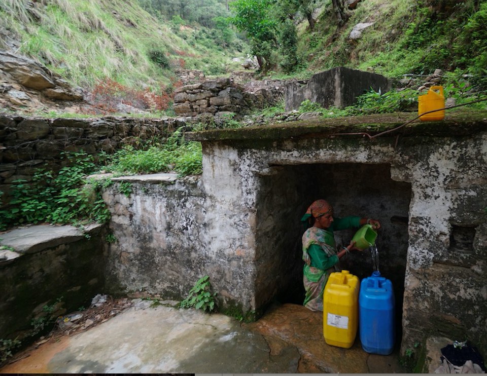
Naulas are shallow, four-sided stepped wells designed to collect water from subterranean seepages or springs and are used to meet domestic water needs by the local communities. Naula management and conservation encompasses a range of activities that preserve their structure and function.
- អ្នកចងក្រង៖ Jaclyn Bandy
2. ការពណ៌នាពីបច្ចេកទេស SLM
2.1 ការពណ៌នាដោយសង្ខេបពីបច្ចេកទេស
និយមន័យបច្ចេកទេស:
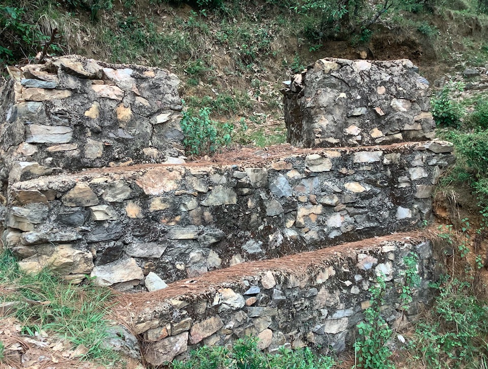
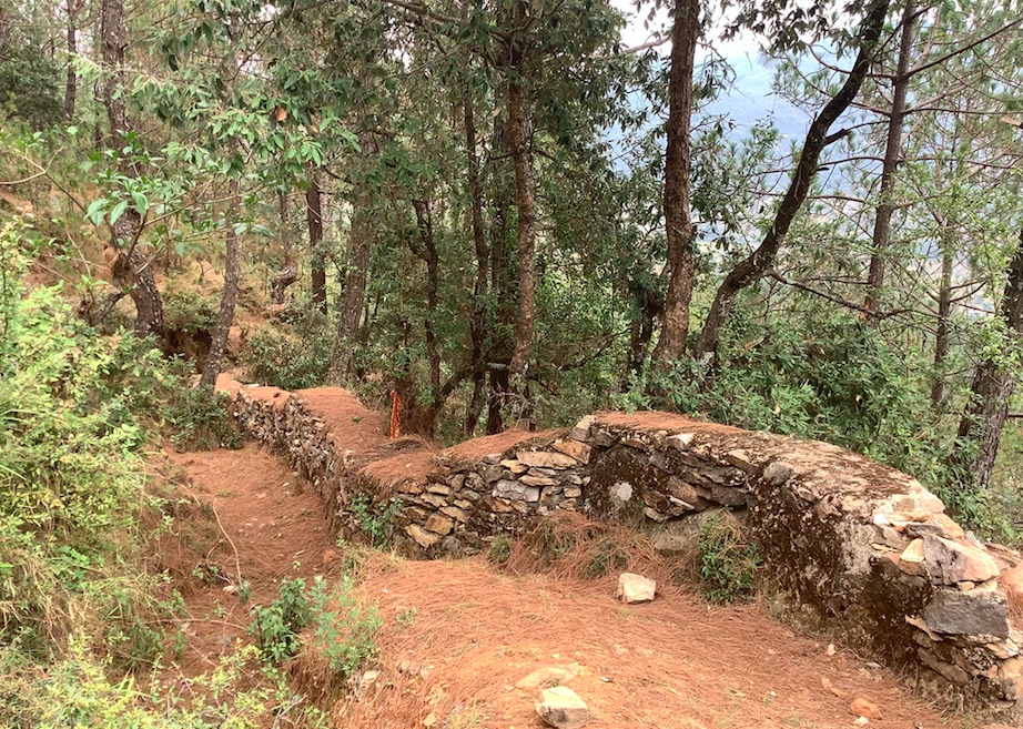
Stone Check Dams/Walls, Retainment Walls, and a Water Diversion Wall has been constructed in Nakina Village and Nakina Community Forest to help protect their settlements, agriculture land, forest land, and preserve the hilly landscape. These structures serve to reduce the runoff velocity (lowering the rate of erosion and gullying in steep slope channels) and increase infiltration for groundwater recharge.
2.2 ការពណ៌នាលម្អិតពីបច្ចេកទេស
ការពណ៌នា:
1. The technology is found in both natural and human environments (forest and settlement areas)
2. Main Characteristics: A check dam or check wall is constructed in a loose or active gully or a rill (shallow channel) that threatens to enlarge, or anywhere on a slope where there is a danger of scour from running water. The structures lower the velocity of flow. In Nakina porous check walls, check dams, and retainment walls were made out of stone gathered from the surrounding area. A porous check dam releases a portion of flow through the structure, decreases the head of flow over the spillway, and decreases the dynamic and hydrostatic forces against the check dam. Porous check dams are simple and more economical for construction.
Once stones are collected they are cut into suitable sizes and surfaces ( "dressing" of stones). The site where the technology is to be constructed is then cleared and, for check dams, the sides are sloped 1:1 (this simply refers to the ratio of the rise and run of the slope, so 1:1 means you'll have a 45 degree slope for your excavation). This is also known as the angle of repose, where the granular material of the embankment will be stable and not slump from its own weight. The base of the dam should be around 70 cm thick if it is 1 meter high. The bed of gully is excavated for foundation and dry stones are packed from that level.
3. Purposes/functions: Interrupts the flow of water and flattens the gradient of a channel, thereby reducing the velocity and inducing infiltration rather than eroding the channel. These structures not only slow flow velocity but also to distribute flows across vegetation. Despite some sedimentation resulting behind the dam, small cracks and porous spaces in the holes of the stones allow some sediment to flow through and the finer particles fill the gaps and strengthen the structure. Check dams can also be designed to create small reservoirs.
4. Major activities include identifying the appropriate site of installation, collection of construction materials, technical planning of the structure dimensions and design, manual labor, and maintenance.
5. Benefits/impacts: These structures decelerate runoff and accelerates groundwater recharging by storing water and facilitating infiltration of water into the soil
6. Like/Dislike:
Advantages
•Inexpensive and relatively easy to install given local building materials and labor availability
•Reduce velocity, prevent gully erosion and cause a high proportion of the sediment load in runoff to settle out, preventing downstream damage
•When carefully located and designed, check dams can remain as permanent installations with very minor regrading
Disadvantages
•Many of these structures have a temporary nature, and need to reconstructed or removed after significant damage
•Removal or reconstruction may be a significant cost depending on the size and design
•May kill grass linings in channels if the water level remains high after rainstorms or if there is significant sedimentation.
•May create turbulence which erodes the channel banks.
•Clogging by organic material may be a problem and hinder the structure's function
2.3 រូបភាពនៃបច្ចេកទេស
វិចិត្រសាលប្រព័ន្ធផ្សព្វផ្សាយ
2.5 ប្រទេស/តំបន់/ទីតាំងកន្លែង ដែលបច្ចេកទេសត្រូវបានអនុវត្ត និងបានគ្រប់ដណ្តប់ដោយការវាយតម្លៃនេះ
ប្រទេស:
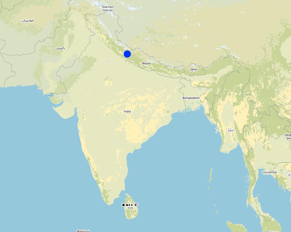
ប្រទេសឥណ្ឌា
តំបន់/រដ្ឋ/ខេត្ត:
Uttarakhand
បញ្ជាក់បន្ថែមពីលក្ខណៈនៃទីតាំង:
Nakina Village, Pithoragarh Bloc
បញ្ជាក់ពីការសាយភាយនៃបច្ចេកទេស:
- អនុវត្តនៅកន្លែងជាក់លាក់មួយ/ ប្រមូលផ្តុំនៅតំបន់តូចៗ
តើបច្ចេកទេស (មួយ ឬច្រើន) ទាំងនោះស្ថិតនៅក្នុងតំបន់ការពារជាអចិន្ត្រៃយ៍ណាមួយដែរឬទេ?
បាទ/ចា៎
បើបាទ/ច៎ា សូមបញ្ជាក់:
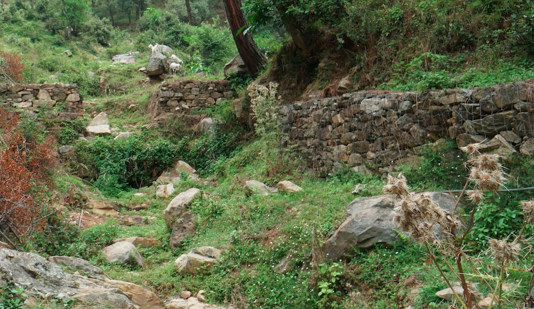
5 check dams are located in the protected forest of Nakina. The other structures are located in the village settlement (the 5 check walls are within the ravine) or just above the Bhind Spring (Naula).
Map
×2.6 កាលបរិច្ឆេទនៃការអនុវត្ត
ប្រសិនបើមិនច្បាស់ឆ្នាំ សូមបញ្ជាក់កាលបរិច្ឆេទដែលប្រហាក់ប្រហែល:
- ច្រើនជាង 50 ឆ្នាំមុន (ប្រពៃណី)
2.7 ការណែនាំពីបច្ចេកទេស
សូមបញ្ជាក់តើបច្ចេកទេសត្រូវបានណែនាំឱ្យអនុវត្តដោយរបៀបណា:
- តាមរយៈការបង្កើតថ្មីរបស់អ្នកប្រើប្រាស់ដី
- ជាផ្នែកនៃប្រព័ន្ធប្រពៃណី (> 50 ឆ្នាំ)
- តាមរយៈគម្រោង / អន្តរាគមន៍ពីខាងក្រៅ
មតិយោបល់ (ប្រភេទនៃគម្រោង ។ល។):
Check dams and other retainment structures are technologies that have been used for centuries. Some of the structures in the village are nearly +50 years old and have either been constructed with the help of the government (ravine check dams in settlement and above Bhind Naula) and others have been more recently constructed by the villagers themselves to support the forest landscape, specifically springshed recharge.
3. ចំណាត់ថ្នាក់នៃបច្ចេកទេស SLM
3.1 គោលបំណងចម្បង (១ ឬច្រើន) នៃបច្ចេកទេសនេះ
- កាត់បន្ថយ, បង្ការ, ស្តារឡើងវិញនូវការធ្លាក់ចុះគុណភាពដី
- អភិរក្សប្រព័ន្ធអេកូឡូស៊ី
- ការពារតំបន់ទីជម្រាល/តំបន់ខ្សែទឹកខាងក្រោមបញ្ចូលជាមួយបច្ចេកទេសផ្សេងទៀត
- កាត់បន្ថយហានិភ័យនៃគ្រោះមហន្តរាយ
- បន្ស៊ាំទៅនឹងការប្រែប្រួលអាកាសធាតុ/គ្រោះមហន្តរាយ និងផលប៉ះពាល់របស់វា
3.2 ប្រភេទដីប្រើប្រាស់មួយប្រភេទ (ច្រើនប្រភេទ) ដែលបានអនុវត្តបច្ចេកទេស

ដីព្រៃ/ដីដាំដើមឈើ
- ព្រៃ (ពាក់កណ្តាល) ធម្មជាតិ/ ដីព្រៃ
ព្រៃ (ពាក់កណ្តាល) ធម្មជាតិ / ដីព្រៃ៖ បញ្ជាក់ប្រភេទនៃការគ្រប់គ្រង:
- កាប់តែមួយចំនួន
ប្រភេទព្រៃ (ពាក់កណ្តាល) ធម្មជាតិ:
- សារពើរុក្ខជាតិនៃព្រៃស្ងួតធម្មជាតិតំបន់ពាក់កណ្តាលត្រូពិច
- quercus leucotrichophora (Banj oak)
តើប្រភេទឈើខាងលើជាប្រភេទឈើក្នុងព្រៃល្បោះ ឬស្រោង?
- ព្រៃល្បោះ
ផលិតផល និងសេវាកម្ម:
- ឈើហ៊ុប
- អុស
- វាលស្មៅ
- ការអភិរក្ស/ការការពារធម្មជាតិ

លំនៅដ្ឋាន ហេដ្ឋារចនាសម្ព័ន្ធ
- ដីលំនៅស្ថាន អគារ
3.3 បន្ទាប់ពីអនុវត្តបច្ចេកទេស តើដីប្រើប្រាស់មានការប្រែប្រួលដែររឺទេ?
បន្ទាប់ពីអនុវត្តបច្ចេកទេស តើដីប្រើប្រាស់មានការប្រែប្រួលដែររឺទេ?
- ទេ (បន្តទៅសំណួរ 3.4)
3.4 ការផ្គត់ផ្គង់ទឹក
ការផ្គត់ផ្គង់ទឹកនៅកន្លែងអនុវត្តបច្ចេកទេស:
- ទឹកភ្លៀង
3.5 ក្រុម SLM ដែលបច្ចេកទេសស្ថិតនៅក្នុង
- វិធានការអនុវត្តកាត់ទទឹងទីជម្រាល
- ការបែងចែកទឹក និងប្រព័ន្ធបង្ហូរ
- ការគ្រប់គ្រងទឹកលើដី (ទឹកធ្លាក់ ទន្លេ បឹង សមុទ្រ)
3.6 វិធានការ SLM ដែលបញ្ចូលនូវបច្ចេកទេស

វិធានការរចនាស័ម្ពន្ធ
- S3: កម្ពស់ភ្លឺ ប្រឡាយ ផ្លូវទឹក
- S6: ជញ្ជាំង, របាំង, របងឈើខ្ពស់ៗ
3.7 កំណត់ប្រភេទនៃការធ្លាក់ចុះគុណភាពដីសំខាន់ៗដែលបច្ចេកទេសនេះបានដោះស្រាយ

ការហូរច្រោះដីដោយសារទឹក
- Wt: ការបាត់ដីស្រទាប់លើដោយការហូរច្រោះ
- Wg: ការកកើតឡើងនូវកំទេចកំទីដីស្រទាប់ក្រោម
- Wm: ការបាក់ដី
- Wr: សំណឹកដីច្រាំងទន្លេ
- Wo: ផលប៉ះពាល់នៃការធ្លាក់ចុះគុណភាពកន្លែងឆ្ងាយ

ការបាត់បង់រូបសាស្ត្រនៃដី
- Ps: ការស្រុតចុះនូវសារធាតុសរីរាង្គនៃដី ការពន្លិចដី

ការធ្លាក់ចុះជីវសាស្ត្រនៃដី
- Bc: ការថយចុះនូវគម្របរុក្ខជាតិ
- Bq: ការថយចុះនូវជីវម៉ាស/ បរិមាណ

ការបាត់បង់ទឹក
- Hg: ការប្រែប្រួលបរិមាណទឹកនៅក្រោមដី
3.8 ការពារ កាត់បន្ថយ ឬស្តារឡើងវិញនៃការធ្លាក់ចុះគុណភាពដី
បញ្ជាក់ពីគោលដៅរបស់បច្ចេកទេស ដែលផ្តោតទៅការធ្លាក់ចុះគុណភាពដី:
- ការការពារការធ្លាក់ចុះគុណភាពដី
- ការកាត់បន្ថយការធ្លាក់ចុះគុណភាពដី
4. បច្ចេកទេសជាក់លាក់ សកម្មភាពអនុវត្ត ធាតុចូល និងថ្លៃដើម
4.1 គំនូសបច្ចេកទេសនៃបច្ចេកទេសនេះ
ឈ្មោះអ្នកនិពន្ធ:
Jaclyn Bandy
កាលបរិច្ឆេទ:
02/08/2019
ឈ្មោះអ្នកនិពន្ធ:
Jaclyn Bandy
កាលបរិច្ឆេទ:
02/08/2019
ឈ្មោះអ្នកនិពន្ធ:
Jaclyn Bandy
កាលបរិច្ឆេទ:
02/08/2019
ឈ្មោះអ្នកនិពន្ធ:
Jaclyn Bandy
កាលបរិច្ឆេទ:
02/08/2019
4.2 ព័ត៌មានទូទៅដែលពាក់ព័ន្ធនឹងការគណនាធាតុចូល និងថ្លៃដើម
កំណត់របៀបនៃការគណនាថ្លៃដើម និងធាតុចូល:
- ក្នុងឯកតាបច្ចេកទេស
បញ្ជាក់ឯកតា:
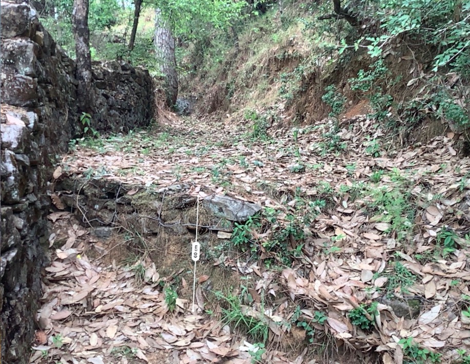
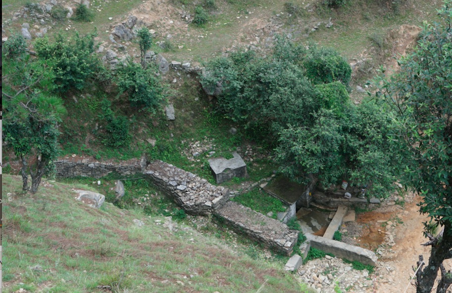
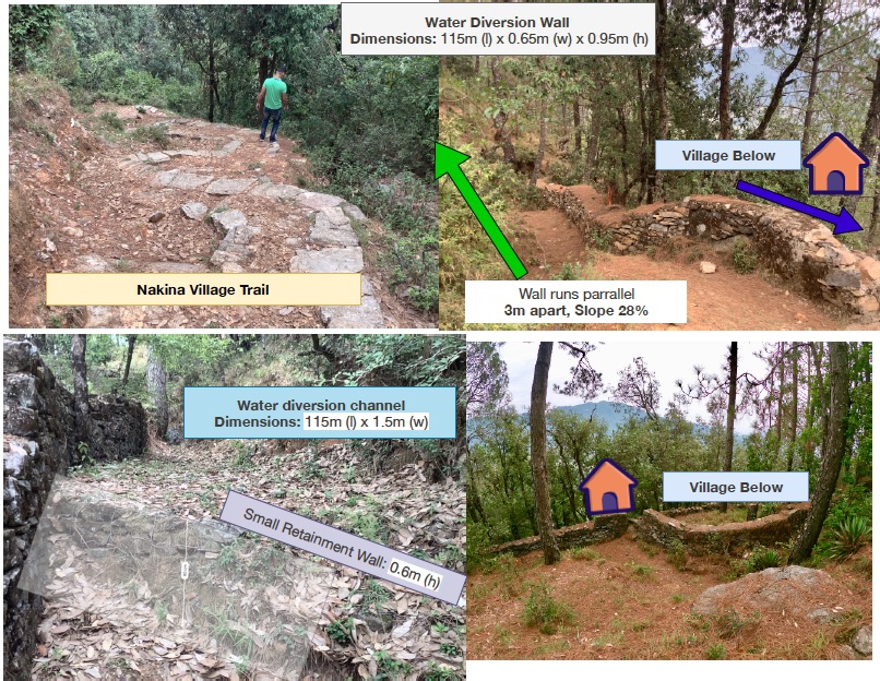
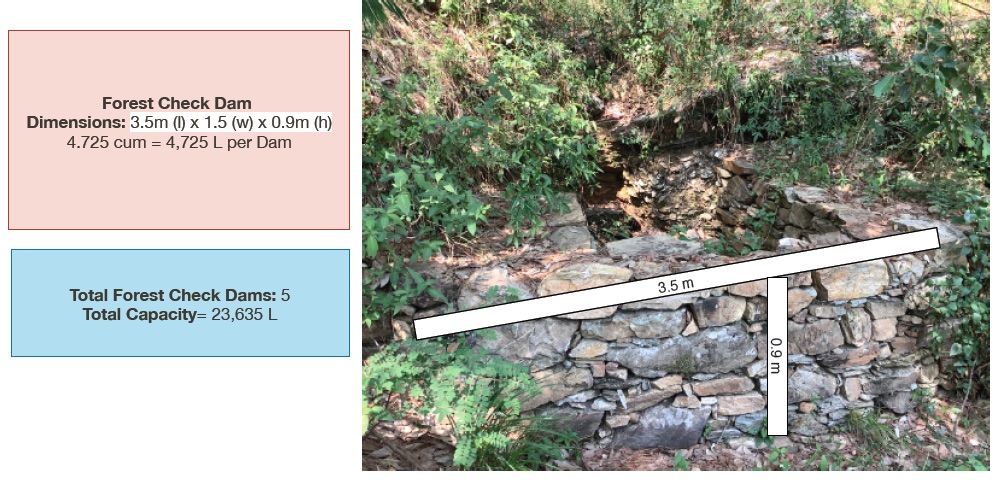
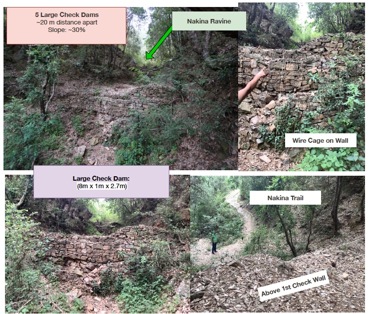
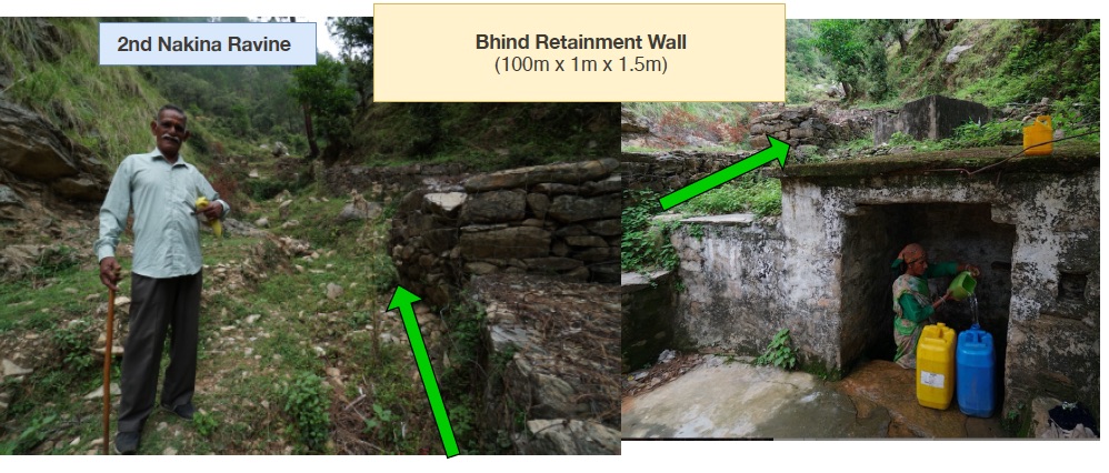
1. Small Check Dams 2. Large Check Walls 3. Water Diversion Wall 4. Bhind Check Walls/Retainment wall
បញ្ជាក់ពីទំហំនៃឯកតា (បើពាក់ព័ន្ធ):
1. 5 units (3.5m x 1.5m x 0.9m) 2. 5 units (8m x 1m x 2.7m) 3. 1 unit (115m x 0.65 x 0.95m) 4. 1 unit (100m x 1m x 1.5m)
ផ្សេងៗ/ រូបិយប័ណ្ណជាតិ (បញ្ជាក់):
INR
បើពាក់ព័ន្ធសូមកំណត់អត្រាប្តូរប្រាក់ពីដុល្លាទៅរូបិយប័ណ្ណតំបន់ (ឧ. 1 ដុល្លារ = 79.9 រៀលនៃរូបិយប័ណ្ណប្រេស៊ីល) ៖ 1 ដុល្លារ =:
70,0
កំណត់ថ្លៃឈ្នួលជាមធ្យមនៃការជួលកម្លាំងពលកម្មក្នុងមួយថ្ងៃ:
400 INR per head/day
4.3 សកម្មភាពបង្កើត
| សកម្មភាព | រយៈពេល (រដូវកាល) | |
|---|---|---|
| 1. | Nakina village built a long water diversion wall over +50 years ago that serves as a water channel, directing runoff away from settlements and towards the ravine | Pre-monsoon /dry season |
| 2. | Within the ravine/gully in Nakina Village, there is a series of 5 large check walls that were established with the help of the Forest Department | Pre-monsoon /dry season |
| 3. | There is a series of check walls/check dams in another gully that were established in 1952 above the Bhind Spring/Naula (on the opposite side of the village) to protect it and decrease runoff/further erosion | Pre-monsoon/dry season |
| 4. | In December 2017 the Nakina Van Panchayat (community forest council) decided to construct 5 new check dams within the Nakina Forest, which lie in the upper catchment area of the Bhind Spring | Pre-monsoon/dry season |
| 5. | For the establishment of all these structures, the community and technical assistants assessed the topography of the area, size of the gully, catchment area and runoff rate before establishing the check-dam. | Pre-monsoon/dry season |
| 6. | The sites were selected and prepared by removing debris and other unsuitable material which would interfere with proper placement of the check dam/wall materials. | Pre-monsoon/dry season |
4.4 ថ្លៃដើម និងធាតុចូលដែលត្រូវការសម្រាប់ការបង្កើតបច្ចេកទេស
| បញ្ជាក់ពីធាតុចូល | ឯកតា | បរិមាណ | ថ្លៃដើមក្នុងមួយឯកតា | ថ្លៃធាតុចូលសរុប | % នៃថ្លៃដើមដែលចំណាយដោយអ្នកប្រើប្រាស់ដី | |
|---|---|---|---|---|---|---|
| កម្លាំងពលកម្ម | Large Water Diversion Wall | person-days | 60,0 | 400,0 | 24000,0 | 20,0 |
| កម្លាំងពលកម្ម | 5 Large Check Walls | person-days | 50,0 | 400,0 | 20000,0 | 20,0 |
| កម្លាំងពលកម្ម | Bhind Spring Check Walls/Retainment Wall | person-days | 19,0 | 400,0 | 7600,0 | 50,0 |
| កម្លាំងពលកម្ម | 5 Small Check Walls in Forest | person-days | 10,0 | 400,0 | 4000,0 | 100,0 |
| សម្ភារៈ | Crate Wire (15m x 2m x 2m) | Cum | 60,0 | 75,0 | 4500,0 | |
| សម្ភារៈ | Pick | pieces | 15,0 | 300,0 | 4500,0 | 100,0 |
| សម្ភារៈ | Shovel | pieces | 20,0 | 500,0 | 10000,0 | 100,0 |
| សម្ភារៈ | pharuwa (hoe) | pieces | 15,0 | 300,0 | 4500,0 | 100,0 |
| សម្ភារៈ | khanti (digging bar) | pieces | 10,0 | 1500,0 | 15000,0 | 100,0 |
| សម្ភារៈ | hammer (5kg) | pieces | 10,0 | 2000,0 | 20000,0 | 100,0 |
| សម្ភារៈ | chino (chisel) | pieces | 10,0 | 500,0 | 5000,0 | 100,0 |
| សម្ភារៈ | khukuri (knife) | pieces | 10,0 | 250,0 | 2500,0 | 100,0 |
| សម្ភារៈដាំដុះ | small hammer (0.5-1 kg) | pieces | 15,0 | 300,0 | 4500,0 | 100,0 |
| សម្ភារៈសាងសង់ | Rocks of various size and shape collected/excavated on site | |||||
| សម្ភារៈសាងសង់ | Small Check Walls in Forest (5) | cum | 23,625 | 200,0 | 4725,0 | 100,0 |
| សម្ភារៈសាងសង់ | Large Check Walls (5) | cum | 108,0 | 200,0 | 21600,0 | 20,0 |
| សម្ភារៈសាងសង់ | Large Water Diversion Wall (1) | cum | 71,0 | 200,0 | 14200,0 | 100,0 |
| សម្ភារៈសាងសង់ | Bhind Check Walls/Retainment Wall (5) | cum | 150,0 | 200,0 | 30000,0 | 50,0 |
| ផ្សេងៗ | Rocks of various size and shape collected/excavated on site | |||||
| ថ្លៃដើមសរុបក្នុងការបង្កើតបច្ចេកទេស | 196625,0 | |||||
| ថ្លៃដើមសរុបក្នុងការបង្កើតបច្ចេកទេសគិតជាដុល្លារ | 2808,93 | |||||
ប្រសិនបើអ្នកប្រើប្រាស់ដីមិនមានថ្លៃដើម 100% សូមបញ្ជាក់ថានរណាដែលចំណាយថ្លៃដើមដែលនៅសល់:
Uttarakhand Forest Department (Government), JICA (Japan International Cooperation Agency)
មតិយោបល់:
Cost Estimate: 200 INR/cum
Example:
1. Small Check Dams: 5 units (3.5m x 1.5m x 0.9m) ----- 4.725 cum x 200 INR = 945 INR/unit
945 INR/unit x 5 units = 4,725 Rs
or...
(4.725 cum/unit x 5 unit = 23.625 total cum )
(23.625 total cum x 200 INR = 4,725 Rs.)
2. Large Check Walls: 5 units (8m x 1m x 2.7m) -----21.6 x 200 = 4320
4320 cum x 5 units = 21,600 Rs
3. Water Diversion Wall: 1 unit (115m x 0.65 x 0.95m) ------71 x 200= 14,200
14,200 X 1 unit= 14,200 Rs
3. Bhind Spring Check Walls/Retainment Wall: 1 unit (100m x 1m x 1.5m) = 150 total cum
150 x 200 INR = 30,000 INR Total
4.5 សកម្មភាពថែទាំ
| សកម្មភាព | ពេលវេលា/ ភាពញឹកញាប់ | |
|---|---|---|
| 1. | Inspection of the check dam for rock displacement and erosion around the ends of the dam after each significant rainfall event | Monsoon/ weekly |
| 2. | Sediment accumulation is removed if it reaches a depth of ½ the original dam height | Pre-monsoon/Monsoon |
| 3. | Sometimes check dams are removed when their useful life is completed | Annual inspections |
4.6 កំណត់ថ្លៃដើមសម្រាប់ការថែទាំ/ សកម្មភាពរបស់បច្ចេកទេស (ក្នុងរយៈពេលមួយឆ្នាំ)
| បញ្ជាក់ពីធាតុចូល | ឯកតា | បរិមាណ | ថ្លៃដើមក្នុងមួយឯកតា | ថ្លៃធាតុចូលសរុប | % នៃថ្លៃដើមដែលចំណាយដោយអ្នកប្រើប្រាស់ដី | |
|---|---|---|---|---|---|---|
| កម្លាំងពលកម្ម | Reconstruction of damaged check dams | person-days/unit | 10,0 | 400,0 | 4000,0 | 100,0 |
| កម្លាំងពលកម្ម | Removal of sediment | person-days/unit | 5,0 | 400,0 | 2000,0 | 100,0 |
| សម្ភារៈ | pick | pieces | 3,0 | 70,0 | 210,0 | 100,0 |
| សម្ភារៈ | shovel | pieces | 3,0 | 42,0 | 126,0 | 100,0 |
| សម្ភារៈ | pharuwa (hoe) | pieces | 2,0 | 52,0 | 104,0 | 100,0 |
| សម្ភារៈ | khanti (digging bar) | pieces | 2,0 | 30,0 | 60,0 | 100,0 |
| សម្ភារៈ | hammer | pieces | 3,0 | 25,0 | 75,0 | 100,0 |
| សម្ភារៈ | chino (chisel) | pieces | 2,0 | 75,0 | 150,0 | 100,0 |
| សម្ភារៈ | khukuri (knife) | pieces | 2,0 | 22,0 | 44,0 | 100,0 |
| សម្ភារៈ | small hammer (0.5-1kg) | pieces | 3,0 | 120,0 | 360,0 | 100,0 |
| សម្ភារៈសាងសង់ | Stones available at site locally | |||||
| ថ្លៃដើមសរុបសម្រាប់ការថែទាំដំណាំតាមបច្ចេកទេស | 7129,0 | |||||
| ថ្លៃដើមសរុបសម្រាប់ការថែទាំដំណាំតាមបច្ចេកទេសគិតជាដុល្លារ | 101,84 | |||||
4.7 កត្តាសំខាន់បំផុតដែលមានឥទ្ធិពលដល់ការចំណាយ
ពណ៌នាពីកត្តាប៉ះពាល់ចម្បងៗទៅលើថ្លៃដើម:
Size of the check dam/check wall
Frequency and intensity of the damage to the structures
Labor availability
5. លក្ខណៈបរិស្ថានធម្មជាតិ និងមនុស្ស
5.1 អាកាសធាតុ
បរិមាណទឹកភ្លៀងប្រចាំឆ្នាំ
- < 250 មម
- 251-500 មម
- 501-750 មម
- 751-1,000 មម
- 1,001-1,500 មម
- 1,501-2,000 មម
- 2,001-3,000 មម
- 3,001-4,000 មម
- > 4,000 មម
កំណត់បរិមាណទឹកភ្លៀង (បើដឹង) ជា មីលីម៉ែត្រ:
1500,00
លក្ខណៈពិសេស/ មតិយោបល់លើរដូវភ្លៀង:
Monsoon- mid-June to mid-September; July and August are the rainiest months and the temperature is warm and moist; between 70-85% of the annual precipitation occurs in the monsoon season
Seasons
a. Winter or Cold weather (mid Dec. - mid March)
b. Summer or hot weather (mid March - mid June)
c. Season of general rains (South - West monsoon season)
d. Season of retreating monsoon (mid September to mid November)
បញ្ជាក់ឈ្មោះឯកសារយោងនៃស្ថានីយឧតុនិយម:
India Meteorological Department, Meteorological Centre Dehradun
តំបន់កសិអាកាសធាតុ
- មានភ្លៀងមធ្យម
The overall climatic condition in the Pithoragarh district is governed by the southwest monsoon. It has a sub-tropical to temperate climate, with three pronounced seasons; summer, winter, and monsoon. The hilly terrain of the Himalayan region has snow cover and is cold during winter with snowfall normally occurring during the months of December to March.
Temperature- The temperature ranges from 0°C to 10°C in winter and from 8°C to 33°C in summer season. However, there is no meteorological observatory in the district. The account of the climate is based mainly on the records of the observations in the neighboring districts where similar meteorological conditions prevail. Variations in temperature are considerable from place to place and depend upon elevation as well as aspect. As the insolation is intense at high altitudes, in summer temperatures are considerably higher in the open than in the shade.
5.2 សណ្ឋានដី
ជម្រាលជាមធ្យម:
- រាបស្មើ (0-2%)
- ជម្រាលតិចតួច (3-5%)
- មធ្យម (6-10%)
- ជម្រាលខ្ពស់បន្តិច (11-15%)
- ទីទួល (16-30%)
- ទីទួលចោត (31-60%)
- ទីទួលចោតខ្លាំង (>60%)
ទម្រង់ដី:
- ខ្ពង់រាប
- កំពូលភ្នំ
- ជម្រាលភ្នំ
- ជម្រាលទួល
- ជម្រាលជើងភ្នំ
- បាតជ្រលងភ្នំ
តំបន់តាមរយៈកម្ពស់ :
- 0-100 ម
- 101-500 ម
- 501-1,000 ម
- 1,001-1,500 ម
- 1,501-2,000 ម
- 2,001-2,500 ម
- 2,501-3,000 ម
- 3,001-4,000 ម
- > 4,000 ម
បញ្ជាក់ថាតើបច្ចេកទេសនេះត្រូវបានអនុវត្តន៍នៅក្នុង:
- សណ្ឋានដីផត
មតិយោបល់ និងបញ្ចាក់បន្ថែមអំពីសណ្ឋានដី :
Altitude of evaluated sites: 1800-1990m
Average Slope: 25-+30%
5.3 ដី
ជម្រៅដីជាមធ្យម:
- រាក់ខ្លាំង (0-20 សម)
- រាក់ (21-50 សម)
- មធ្យម (51-80 សម)
- ជ្រៅ (81-120 សម)
- ជ្រៅខ្លាំង (> 120 សម)
វាយនភាពដី (ស្រទាប់លើ):
- គ្រើម/ មានពន្លឺ (ខ្សាច់)
- មធ្យម (ល្បាយ, ល្បាប់)
វាយនភាពដី (> 20 សម ស្រទាប់ក្នុង):
- មធ្យម (ល្បាយ, ល្បាប់)
សារធាតុសរីរាង្គនៅស្រទាប់ដីខាងលើ:
- មធ្យម (1-3%)
- ទាប (<1%)
បើអាចសូមភ្ជាប់ការពណ៌នាពីដីឱ្យបានច្បាស់ ឬព័ត៌មានដែលអាចទទួលបាន ឧ. ប្រភេទដី, pH ដី/ ជាតិអាស៊ីត, សមត្ថភាពផ្លាស់ប្តូរកាចុង, វត្តមាននីត្រូសែន, ភាពប្រៃ ។ល។:
Mountain/hill soils are a collective name given to various types of soils found under the following conditions :
-under sub-tropical, temperate and sub-alpine conditions
-under various forest types
Characteristics: very thin, fertile, and may be less than a centimeter deep on steep slopes; they are mixed with pebbles, shingles (a mass of small rounded pebbles), and gravels; they have a low-medium water holding capacity. Angular and subangular fragments of parent rock may be found mixed with the lower layers of the mountain and hill soils.
Texture: varies from loamy to sandy loam.
Soil Reaction: ranges from acidic to neutral (pH 4.6 to 6.5)
Organic Matter content: 1-5%
Ferrugenous red roils are found in this district and are well developed over Himalayan rocks (quartzite, biotite schist, amphibolite schist). They are free of carbonates and deficient in nitrogen, humus and phosphorus, light textured, porous, and friable (brittle/crumbly). The soil depth ranges from about 10cm-75 cm. These soils may be grouped into two on basis of morphology
1. Red earths- loose, friable topsoil rich in secondary concretions (hard, compact mass of matter formed by the precipitation of mineral cement within the spaces between particles, and is found in sedimentary rock or soil)
2. Red loam- argillaceous soils having a blocky structure (argillaceous minerals may appear silvery upon optical reflection and are minerals containing substantial amounts of clay-like components, e.g. argillaceous limestones are limestones consisting predominantly of calcium carbonate, but including 10-40% of clay minerals)
Brown soil: is found particularly under dense broadleaved temperate and sub-alpine forests. There occurs a thick layer of humus on the forest floor (made of decomposed leaves, branches, twigs) and the topsoil is extremely rich in humus
Podsolic Soil: soil that has developed in humid/temperate conditions usually under coniferous forests (e.g. deodar, blue pine, fir, spruce) over quartzite, granites, schists and gneiss.
Citation: Kumaun: The Land and the People, Sharad Singh Negi (1993)
5.4 ទឹកដែលអាចទាញមកប្រើប្រាស់បាន និងគុណភាពទឹក
នីវ៉ូទឹកក្រោមដី:
> 50 ម
ទឹកលើដីដែលអាចទាញយកប្រើប្រាស់បាន:
កម្រិតមធ្យម
គុណភាពទឹក (មិនបានធ្វើប្រត្តិកម្ម):
ទឹកពិសារដែលមានគុណភាពល្អ
គុណភាពទឹក គឺផ្តោតទៅលើ៖:
ទឹកក្រោមដី
តើមានបញ្ហាភាពទឹកប្រៃហូរចូលមកដែរឬទេ?
ទេ
តើទឹកជំនន់កំពុងកើតមាននៅតំបន់នេះដែររឺទេ?
ទេ
មតិយោបល់ និងលក្ខណៈពិសេសផ្សេងៗទៀតលើគុណភាព និងបរិមាណទឹក :
Quantity: Water crisis has been a perennial problem in both the rural and urban areas of the Pithoragarh district
There is scarcity of safe drinking water of the villages in the study area. Hand pumps are often not functioning, pipe-water schemes are unreliable and the spring discharges have reduced during the dry season. Hand-pumped water often has a high iron content and bitter taste. Poor quality of groundwater in some of the naulas is mainly due to misuse and/or disuse of the structures.
A block-district groundwater resource estimation could not be carried out as the area is hilly (with slope >20%) and in major part aquifers are small, isolated bodies, and groundwater abstraction is done mainly through hand pumps and springs with small discharges.
However, we collected some physicochemical parameters that indicate the water (sourced from springs) is of good quality:
Water Quality Parameters of Springs:
pH: 6.29-8.18
Temp: 19.0-23.5 ºC
Electrical Conductivity: 109-504 µmsiemens
Total Dissolved Solids: 75-385 ppm
Other Parameters (from springs of nearby district, Champawat)
Electrical Conductivity: 127-222 µmsiemens
pH: 7.69-8.24
Calcium: 16-36 mg/l
Magnesium: 4.9-7.3 mg/l
Bicarbonate: 61-134 mg/l
Chloride: 5.3- 8.9 mg/l
Total Hardness as CaCO3: 70-110 mg/l
Source: Government of India Ministry of Water Resources, Central Ground Water Board, 2009 Groundwater Brochure of Champawat District (2009)
5.5 ជីវៈចម្រុះ
ភាពសម្បូរបែបនៃប្រភេទ:
- កម្រិតមធ្យម
ភាពសម្បូរបែបនៃទីជម្រក:
- កម្រិតមធ្យម
មតិយោបល់ និងលក្ខណៈពិសេសផ្សេងទៀតលើជីវចម្រុះ:
Uttarakhand has more than 7000 species of medicinal plants and 500 species of fauna. Floral diversity contributes 31% of total floral density of India. Fauna contributes just 1.58% of the total faunal density of the country. There are 119 endemic species of flowering plants in the state that exhibited 2.35% endemism and 35 faunal endemic species. Because it lies at the juncture of India, Nepal and the Tibeten Autononmous region, there often cases of poaching and smuggling of wildlife contrabands, including bear bile, musk pods and leopard skins through the borders. Yarsa Gumba Ophiocordyceps sinensis, commonly known as Caterpillar Fungus, is also illegally traded transboundary in the region, together with various plant species. Due to anthropogenic impacts, changes is soil quality, and climatic elements, the biodiversity of our study site is not as high as in other areas of the Pithoragarh district.
Citation: Sundriyal, M. & Sharma, B. (2016). Status of Biodiversity in Central Himalaya, Applied Ecology and Environmental Sciences, 4( 2), 37-43.
5.6 លក្ខណៈនៃអ្នកប្រើប្រាស់ដីដែលអនុវត្តបច្ចេកទេស
នៅមួយកន្លែង ឬពនេចរ :
- នៅមួយកន្លែង
ទីផ្សារនៃប្រព័ន្ធផលិតកម្ម:
- សម្រាប់ហូបក្នុងគ្រួសារ (ផ្គត់ផ្គង់ខ្លួនឯង)
- ពាក់កណ្តាលពាណិជ្ជកម្ម (ផ្គត់ផ្គង់ខ្លួនឯង/ ពាណិជ្ជកម្ម)
ចំណូលក្រៅកសិកម្ម:
- 10-50% នៃចំណូល
កម្រិតជីវភាព:
- មិនល្អ
ឯកជន ឬក្រុម:
- ជាក្រុម/ សហគមន៍
កម្រិតប្រើប្រាស់គ្រឿងយន្ត:
- ប្រើកម្លាំងពលកម្ម
យេនឌ័រ:
- ស្ត្រី
- បុរស
អាយុរបស់អ្នកប្រើប្រាស់ដី:
- យុវវ័យ
- វ័យកណ្តាល
- មនុស្សចាស់
សូមបញ្ជាក់ពីលក្ខណៈពាក់ព័ន្ធផ្សេងទៀតអំពីអ្នកប្រើប្រាស់ដី:
With recent development in Pithoragarh, an influx of funds coming from outside sources has caused a decline in the importance of agriculture production, which in now marginalized, based on female labour, and mainly conducted for subsistence with little surplus to sell. High caste men do not work in cultivation at all, and male tasks such as ploughing are performed by the Scheduled Caste.
Although most women are still cultivating, their work has lost economic importance. For most families, the produce does not cover the needs of the household and surplus must be bought from the market. Many of the terraces that were formerly fruit orchards (mainly citrus) have been completely abandoned. Farming is less intensive and landholdings are small and fragmented. The main crops are wheat, millet, and pulses, but yields are low as the land is not irrigated. Less livestock (cows, goats, buffalo) is kept because of the labor involved. Very little capital is returned to farming. Crops produced for the markets in the plains are replacing traditional crops to sustain the household.
With exposure to the“Modern” lifestyle, new values have also been accepted. Two children are the norm (the ideal being one son and one daughter, but at least one son in a must). Although access to education is quite good, it does not seem to result in working careers for women. The women, both young and old, spend their days with domestic and agriculture work. Several village persons stated that it would be best to educate their daughters so they could get a government job.
5.7 ទំហំផ្ទៃដីជាមធ្យមនៃដីប្រើប្រាស់ដោយអ្នកប្រើប្រាស់ដី ក្នុងការអនុវត្តបច្ចេកទេស
- < 0.5 ហិកតា
- 0.5-1 ហិកតា
- 1-2 ហិកតា
- 2-5 ហិកតា
- 5-15 ហិកតា
- 15-50 ហិកតា
- 50-100 ហិកតា
- 100-500 ហិកតា
- 500-1,000 ហិកតា
- 1,000-10,000 ហិកតា
- > 10,000 ហិកតា
តើផ្ទៃដីនេះចាត់ទុកជាទំហំកម្រិតណាដែរ ខ្នាតតូច មធ្យម ឬខ្នាតធំ (ធៀបនឹងបរិបទតំបន់)?
- ខ្នាតតូច
5.8 ភាពជាម្ចាស់ដី កម្មសិទ្ធប្រើប្រាស់ដី និងកម្មសិទ្ធប្រើប្រាស់ទឹក
ភាពជាម្ចាស់ដី:
- ភូមិ
កម្មសិទ្ធិប្រើប្រាស់ដី:
- ជាក្រុម (មានដែនកំណត់)
កម្មសិទ្ធប្រើប្រាស់ទឹក:
- អាស្រ័យផលសេរី (មិនមានការកំណត់)
- ជាក្រុម (មានដែនកំណត់)
តើកម្មសិទ្ធប្រើប្រាស់ដី គឺផ្អែកលើប្រព័ន្ធច្បាប់បែបបុរាណ?
បាទ/ចា៎
សូមបញ្ជាក់:
Under the Kumaun Panchayat forest rules of 1931 (amended in 1976): A Van Panchayat, (community forest council), can be formed out of non-private land within the settlement boundaries of a village. Accordingly, all villagers are members of the VP upon their approval by a Sub-Divisional Magistrate under the state Revenue Department. The members are collectively referred to as the general body, which selects the management committee members through a democratic process.
មតិយោបល់:
5-9 elected members assume control and regulation of forest resources. They additionally raise funds and mobilize the village to protect and support sustainable land use.
5.9 ការប្រើប្រាស់សេវាកម្ម និងហេដ្ឋារចនាសម្ព័ន្ធ
សុខភាព:
- មិនល្អ
- មធ្យម
- ល្អ
ការអប់រំ:
- មិនល្អ
- មធ្យម
- ល្អ
ជំនួយបច្ចេកទេស:
- មិនល្អ
- មធ្យម
- ល្អ
ការងារ (ឧ. ការងារក្រៅកសិដ្ឋាន):
- មិនល្អ
- មធ្យម
- ល្អ
ទីផ្សារ:
- មិនល្អ
- មធ្យម
- ល្អ
ថាមពល:
- មិនល្អ
- មធ្យម
- ល្អ
ផ្លូវ និងការដឹកជញ្ជូន:
- មិនល្អ
- មធ្យម
- ល្អ
ទឹកផឹក និងអនាម័យ:
- មិនល្អ
- មធ្យម
- ល្អ
សេវាកម្មហិរញ្ញវត្ថុ:
- មិនល្អ
- មធ្យម
- ល្អ
មតិយោបល់:
The situation of infrastructure is difficult and inconsistent in the hill regions because of the terrain. The major infrastructural issues are drinking water and irrigation facilities, electricity, transportation and communication facilities and social infrastructure (housing and education). As for financial services, only the State Bank of India (SBI) is active in the hill regions where it is trying to achieve the objective of 100% financial inclusion. Some villages mentioned buying into into agricultural insurance in the past, however this was a temporary enterprise and they were never compensated after extreme climatic events that occurred and damaged over 70% of their crop.
Though infrastructure and education has generally improved over the years, institutional and marketing networks in the region aimed at supporting hill-farmers are lacking.
6. ផលប៉ះពាល់ និងការសន្និដ្ឋាន
6.1 ផលប៉ះពាល់ក្នុងបរិវេណអនុវត្តបច្ចេកទេសដែលកើតមាន
ផលប៉ះពាល់លើសេដ្ឋកិច្ចសង្គម
ផលិតផល
គុណភាពព្រៃឈើ/ដីព្រៃ
ការគ្រប់គ្រងដី
មតិយោបល់/ ការបញ្ជាក់:
The check dams helped deter the damage from runoff to their settlements and conserved the forest trail that is commonly used to access the areas where fodder/grass collection is permitted.
ផលប៉ះពាល់ទៅលើវប្បធម៌សង្គម
ចំណេះដឹង SLM / ការធ្លាក់ចុះគុណភាពដី
មតិយោបល់/ ការបញ្ជាក់:
People have seen the benefits of constructing these structures, and they continue to participate in maintaining and building more check dams to reduce erosion and increase groundwater recharge.
ផលប៉ះពាល់ទៅលើអេកូឡូស៊ី
វដ្តទឹក/លំហូរ
បរិមាណទឹក
ការប្រមូលស្តុកទុកទឹក
លំហូរទឹកលើផ្ទៃដី
ប្រព័ន្ធបង្ហូរទឹក
នីវ៉ូទឹកក្រោមដី/ ដង្ហើមទឹក
រំហួត
ដី
សំណើមដី
គម្របដី
ការបាត់បង់ដី
ការកើនឡើងដី
ដីប្រេះ
ដីហាប់
វដ្តនៃសារធាតុចិញ្ចឹម/ការទទួលបាន
ជីវចម្រុះ៖ ដំណាំ, សត្វ
ដំណាំគម្រប
ជីវម៉ាស/ កាបូនលើដី
ការកាត់បន្ថយហានិភ័យនៃគ្រោះមហន្តរាយ និងគ្រោះអាកាសធាតុ
ដីបាក់/ លំហូរកំទិចកំទី
ផលប៉ះពាល់នៃគ្រោះរាំងស្ងួត
ផលប៉ះពាល់នៃព្យុះស៊ីក្លូន/ព្យុះភ្លៀង
ហានិភ័យនៃភ្លើងឆេះព្រៃ
អាកាសធាតុ
6.2 ផលប៉ះពាល់ក្រៅបរិវេណអនុវត្តបច្ចេកទេសដែលកើតមាន
ទឹកដែលអាចទាញមកប្រើប្រាស់បាន
លំហូរទឹកដែលអាចប្រើប្រាស់បាននៅរដូវប្រាំង
កំណកល្បាប់ខ្សែទឹកខាងក្រោម
Buffering/សមត្ថភាពចម្រោះ
ខូចខាតដល់ស្រែអ្នកជិតខាង
ខូចខាតដល់ហេដ្ឋារចនាសម្ព័ន្ធសាធារណៈ/ឯកជន
6.3 ភាពប្រឈម និងភាពរួសនៃបច្ចេកទេសទៅនឹងការប្រែប្រួលអាកាសធាតុ និងគ្រោះអាកាសធាតុ/ គ្រោះមហន្តរាយ (ដែលដឹងដោយអ្នកប្រើប្រាស់ដី)
ការប្រែប្រួលអាកាសធាតុ
ការប្រែប្រួលអាកាសធាតុ
| រដូវកាល | កើនឡើង ឬថយចុះ | លក្ខណៈឆ្លើយតបនៃបច្ចេកទេសទៅនឹងការប្រែប្រួលអាកាសធាតុ | |
|---|---|---|---|
| សីតុណ្ហភាពប្រចាំឆ្នាំ | កើនឡើង | ល្អ | |
| ការប្រែប្រួលអាកាសធាតុផ្សេងៗ | Irregular rainfall | កើនឡើង | ល្អ |
គ្រោះអាកាសធាតុ (មហន្តរាយ)
គ្រោះមហន្តរាយធម្មជាតិ
| លក្ខណៈឆ្លើយតបនៃបច្ចេកទេសទៅនឹងការប្រែប្រួលអាកាសធាតុ | |
|---|---|
| ព្យុះភ្លៀងតាមតំបន់ | ល្អ |
គ្រោះមហន្តរាយអាកាសធាតុ
| លក្ខណៈឆ្លើយតបនៃបច្ចេកទេសទៅនឹងការប្រែប្រួលអាកាសធាតុ | |
|---|---|
| រាំងស្ងួត | ល្អ |
| ភ្លើងឆេះព្រៃ | ល្អ |
គ្រោះមហន្តរាយទឹក
| លក្ខណៈឆ្លើយតបនៃបច្ចេកទេសទៅនឹងការប្រែប្រួលអាកាសធាតុ | |
|---|---|
| ទឹកជំនន់ដោយទឹកភ្លៀង | ល្អ |
| ដីបាក់ | មធ្យម |
មតិយោបល់:
Some check dams and check walls are more durable than others. Depending on the site specific conditions, some do very well after incidences such as after an extreme rainstorm. However this depends on the design/structural soundness, the level of maintenance, and overall hydrological impact. For example, the large check walls in the ravine of Nakina have required immense reconstruction and have required significant effort to maintain, as they receive a huge amount of flow during monsoon each year. The size and slope of the gully are impactful determinants for how sensitive/enduring the structure is.
6.4 ការវិភាគថ្លៃដើម និងអត្ថប្រយោជន៍
តើផលចំណេញ និងថ្លៃដើមត្រូវបានប្រៀបធៀបគ្នាយ៉ាងដូចម្តេច (ទស្សនៈរបស់អ្នកប្រើប្រាស់ដី)?
រយៈពេលខ្លី:
វិជ្ជមាន
រយៈពេលវែង:
វិជ្ជមានខ្លាំង
តើផលចំណេញ និងការថែទាំ/ ជួសជុលត្រូវបានប្រៀបធៀបគ្នាយ៉ាងដូចម្តេច (ទស្សនៈរបស់អ្នកប្រើប្រាស់ដី)?
រយៈពេលខ្លី:
វិជ្ជមាន
រយៈពេលវែង:
វិជ្ជមាន
មតិយោបល់:
Although maintenance can be troublesome and require lots of manual labor for repair, the long term benefits and avoided damage from monsoon runoff outweigh the costs/effort.
6.5 ការទទួលយកបច្ចេកទេស
- > 50%
ក្នុងចំណោមគ្រួសារទាំងអស់ដែលបានអនុវត្តបច្ចេកទេស តើមានប៉ុន្មានគ្រួសារដែលចង់ធ្វើដោយខ្លួនឯង ដោយមិនទទួលបានសម្ភារៈលើកទឹកចិត្ត/ប្រាក់ឧបត្ថម្ភ?:
- 11-50%
មតិយោបល់:
In many cases, collective action is encountered at all stages for these technologies, from planning and construction, to demolition of temporary check-dams without any technical or financial backing from the state.
6.6 ការបន្សុំា
តើថ្មីៗនេះ បច្ចេកទេសនេះត្រូវបានកែតម្រូវដើម្បីបន្ស៊ាំទៅនឹងស្ថានភាពប្រែប្រួលដែរឬទេ?
ទេ
6.7 ភាពខ្លាំង/ គុណសម្បត្តិ/ ឱកាសនៃបច្ចេកទេស
| ភាពខ្លាំង/ គុណសម្បត្តិ/ ឱកាសនៅកន្លែងរបស់អ្នកប្រើប្រាស់ដី |
|---|
| Decrease velocity of runoff and erosive processes to the landscape |
| Support recharge of groundwater/springshed recharge |
| Increase water availability for surrounding vegetation |
| Well constructed check dams function as permanent installations and require little maintenance |
| The technology is relatively inexpensive and easy to install |
| ភាពខ្លាំង/ គុណសម្បត្តិ/ ឱកាស ទស្សនៈរបស់បុគ្គលសំខាន់ៗ |
|---|
| Views aligned with the land-user |
| There is potential for the village to construct more check dams and use the water for storage/irrigation purposes |
6.8 ភាពខ្សោយ/ គុណវិបត្តិ/ ហានិភ័យនៃបច្ចេកទេស និងវិធីសាស្ត្រដោះស្រាយ
| ភាពខ្សោយ/ គុណវិបត្តិ/ ហានិភ័យ ទស្សនៈរបស់អ្នកប្រើប្រាស់ដី | តើបច្ចេកទេសទាំងនោះបានដោះស្រាយបញ្ហាដូចម្តេច? |
|---|---|
| Removal and reconstruction can be costly for some types of check dams | Give thorough attention to the criteria for the site selection to avoid the need for removal; stress the need for maintenance and structure check ups. |
| There can be turbulence downstream, causing erosion of the channel banks. | Vegetative interventions can support these structures, so trees or shrubs can be planted around and in the spaces between check dams to further decrease runoff velocity, increase infiltration, and act as a shock absorber. |
| ភាពខ្សោយ/ គុណវិបត្តិ/ ហានិភ័យ ទស្សនៈរបស់អ្នកចងក្រងឬបុគ្គលសំខាន់ៗ | តើបច្ចេកទេសទាំងនោះបានដោះស្រាយបញ្ហាដូចម្តេច? |
|---|---|
| Aligned with the land user | The government should consider providing appropriate incentives for constructing and managing check-dams, which enable more efficient use of water and also generate the positive externality of recharging ground water in surrounding areas. |
| Check dam construction, if not done by skilled labour, can fail. These situations often arise and become noticeable to the land users when check-dams located upstream are damaged and there is a rapid flow of water to check-dams located downstream. | Special maintenance can be performed by designated people to monitor the status of check dams upstream |
| The large check dams have consistent issues and appear to require more reconstruction. These structures are located downstream and must bear more pressure. The reason for their damage could be inconsistency in repairing existing damage before monsoon. Construction cost is then increased, as additional cost is incurred in removing the accumulated silt and arranging new boulders. | The land users should organize themselves more formally for check dam reconstruction is this area. Collectively generating the necessary capital and labor needed for timely reconstruction may be required from external sources like the Forest Department or JICA organization. |
7. ឯកសារយោង និងវេបសាយ
7.1 វិធីសាស្ត្រ/ ប្រភពនៃព័ត៌មាន
- តាមការចុះទីវាល ការស្រាវជ្រាវនៅទីវាល
4
- ការសម្ភាសន៍ជាមួយអ្នកប្រើប្រាស់ដី
2
តើពេលណាដែលទិន្នន័យបានចងក្រង (នៅទីវាល)?
26/06/2019
7.2 ឯកសារយោងដែលបានចេញផ្សាយ
ចំណងជើង អ្នកនិពន្ធ ឆ្នាំ ISBN:
Evaluation of the effect of porous check dam location on fine sediment retention (a case study), A. M. Hassanli, A. Esmaeli Nameghi, S. Beecham, 2007.
មានប្រភពមកពីណា? ថ្លៃដើមប៉ុន្មាន?
DOI 10.1007/s10661-008-0318-2
7.3 ការភ្ជាប់ទៅកាន់ព័ត៌មានពាក់ព័ន្ធលើប្រព័ន្ធអនឡាញ
ចំណងជើង/ ពណ៌នា:
Mainstreaming Slope Stability Management
វេបសាយ:
http://www.research4cap.org/Library/ScottWilson-LaoPDR-2009-Slopes+Theme8.5+6+Retaining+Wall+Design+PPT+E-SEACAP21-v111220.pdf
ចំណងជើង/ ពណ៌នា:
Policy Brief: Spring Revival through Sustainable Land Management (SLM) in the Himalayan Foothills: Uttarakhand, North India. Author: Liniger HP, Bandy J, Year: 2020
វេបសាយ:
https://www.wocat.net/en/projects-and-countries/projects/onsite-and-offsite-benefits-sustainable-land-management/india
ចំណងជើង/ ពណ៌នា:
Video: SLM for Himalayan Spring Revival. Author: Liniger HP, Bandy J, Year: 2020
វេបសាយ:
https://vimeo.com/429988881
ការតភ្ជាប់ និងម៉ូឌុល
ពង្រីកមើលទាំងអស់ បង្រួមទាំងអស់ការតភ្ជាប់
Community Forest Management in the Nakina Van Panchayat [ប្រទេសឥណ្ឌា]
Van Panchayats or village forest councils are a impressive example of grassroots community management of natural resources, where a specific administrative unit is locally elected by community members who are responsible for the management of activities related to the forest.
- អ្នកចងក្រង៖ Jaclyn Bandy
Naula Management and Conservation [ប្រទេសឥណ្ឌា]
Naulas are shallow, four-sided stepped wells designed to collect water from subterranean seepages or springs and are used to meet domestic water needs by the local communities. Naula management and conservation encompasses a range of activities that preserve their structure and function.
- អ្នកចងក្រង៖ Jaclyn Bandy
ម៉ូឌុល
គ្មានម៉ូឌុល