
The programme of landscape revitalization and integrated river basin management in the Slovak republic for the year 2011 - retention measures in the Sobotište village. [ສະໂລວາເກຍ]
- ການສ້າງ:
- ປັບປູງ:
- ຜູ້ສັງລວມຂໍ້ມູນ: Zuzana Studvova
- ບັນນາທິການ: –
- ຜູ້ທົບທວນຄືນ: David Streiff
Program revitalizácie krajiny a integrovaného manažmentu povodí v Slovenskej republike pre rok 2011 - vodozádržné opatrenia v obci Sobotište. (Slovak language)
approaches_2680 - ສະໂລວາເກຍ
- ສະຫຼຸບສັງລວມຢ່າງທັງໝົດທີ່ເປັນ PDF
- ສັງລວມເປັນບົດ PDF ເພື່ອສັ່ງພິມ
- ສັງລວມເປັນບົດ ຢູ່ໃນ browser
- ບົດສະຫຼຸບ ສະບັບເຕັມ (ບໍ່ມີແບບຟອມ)
- The programme of landscape revitalization and integrated river basin management in the Slovak republic for the year 2011 - retention measures in the Sobotište village.: Aug. 2, 2017 (inactive)
- The programme of landscape revitalization and integrated river basin management in the Slovak republic for the year 2011 - retention measures in the Sobotište village.: Aug. 2, 2017 (public)
ເບິ່ງພາກສ່ວນ
ຂະຫຍາຍທັງໝົດ ຍຸບທັງໝົດ1. ຂໍ້ມູນທົ່ວໄປ
1.2 ລາຍລະອຽດ ການຕິດຕໍ່ ຂອງບຸກຄົນທີ່ຊັບພະຍາກອນ ແລະ ສະຖາບັນ ການມີສ່ວນຮ່ວມ ໃນການປະເມີນຜົນ ແລະ ເອກະສານ ຂອງວິທີທາງ
ຊື່ຂອງໂຄງການ ທີ່ອໍານວຍຄວາມສະດວກ ໃນການສ້າງເອກກະສານ ຫຼື ປະເມີນດ້ານແນວທາງ (ຖ້າກ່ຽວຂ້ອງ)
Sustainable Hill Cultivation Programme1.3 ເງື່ອນໄຂ ຂອງການນໍາໃຊ້ເອກກະສານຂໍ້ມູນ ຂອງ WOCAT
ເມື່ອໃດທີ່ໄດ້ສັງລວມຂໍ້ມູນ (ຢູ່ພາກສະໜາມ)?
01/01/2015
ຜູ້ສັງລວມ ແລະ ບັນດາຜູ້ຕອບແບບສອບຖາມ ຍອມຮັບໃນເງື່ອນໄຂ ການນໍາໃຊ້ຂໍ້ມູນເອກະສານ ທີ່ສ້າງຂື້ນ ໂດຍຜ່ານ ອົງການ WOCAT:
ແມ່ນ
1.4 ເອກະສານອ້າງອີງ (ຫຼາຍ) ກັບແບບສອບຖາມ (ຫຼາຍ) ເຕັກໂນໂລຢີ ຂອງດ້ານການຄຸ້ມຄອງ ດິນແບບຍືນຍົງ
Level ditches in cropland [ສະໂລວາເກຍ]
Conservation measures for eroded cropland. The technology contains level ditches of various lengths, which are digged along a contour.
- ຜູ້ສັງລວມຂໍ້ມູນ: Zuzana Studvova
Wooden check dams [ສະໂລວາເກຍ]
Small wooden check dams built in erosion rills, grooves or gorges to reduce flood risk.
- ຜູ້ສັງລວມຂໍ້ມູນ: Zuzana Studvova
2. ພັນລະນາ ແນວທາງການຄຸ້ມຄອງນໍາໃຊ້ດິນແບບຍືນຍົງ
2.1 ການອະທິບາຍ ໂດຍຫຍໍ້ ຂອງວິທີທາງ
This approach is devoted to the implementation of 'The Landscape Revitalisation Programme and integrated river basins management of the Slovak Republic' in the Sobotište village.
2.2 ການອະທິບາຍ ລາຍລະອຽດ ຂອງວິທີທາງ
ການອະທິບາຍ ລາຍລະອຽດ ຂອງວິທີທາງ:
Aims / objectives: The objective of the first implementation project for 2011 was to create, activate and systematically implement a minimum of 6 million m³ of water retention elements in mountain and foothill areas of forest-agricultural landscape in Slovakia. A particular aim was to create and build landscape water retention systems, terrain elements, facilities and technical solutions in forest, agricultural and urban areas in selected village locations, with the abovementioned cyclical rainwater retention capacity, which will then be operated and
maintained. Another project objective was to force and socially support the creation of employment at community and regional level. The creation of water retention elements and the implementation of revitalisation measures required the creation of a minimum of 2,500 jobs of a seasonal and temporary nature in 2011, including extending existing specialist capacities. This whould also extend the work skills and knowledge necessary for revitalisation of the landscape.
833 municipalities showed interest to participate in this project/approach, while 200 municipalities met the criteria. The project created about 3,500 seasonal jobs in 2011, particularly in regions with high unemployment.
Methods: Criteria and their significance for including villages into the first implementation project are
as follows:
1. 45% - historic or regularly repeated occurrence of flash flooding,
2. 35 % - village is situated in a location with a high potential risk of flooding, in accordance
with modelled potential for the occurrence of flooding. A map of regional and local
potential for flooding in the area of Slovakia1
is at Appendix No. 1,
3. 10% - location of a village in the upper part of river basins, so the implemented measures
will positively decrease the risk of flooding for highest possible number of villages in the
given river basins,
4. 10% - the ratio of documented unemployment is taking into account so citizens of villages
with a high ratio of documented unemployment could contribute towards revitalisation
works.
The submitted methodology of the whole flood potential of Slovakia was prepared on the basis of the work of J. Minár and Co. (2005). The mentioned work focuses upon the
presentation of methodology and results for evaluating the flood creation potential within the whole of Slovakia. It also includes a general description of the modelling of hydrological
processes. The method presented in this work is a good alternative for fast, effective and relatively financially undemanding but still sufficiently reliable analysis of flood risks of
larger areas. The actual calculation of total potential for flooding took place in the technological environment of Geographic Information Systems (GIS) in the following steps
with the stated data:
- calculation of the morphometric potential (incline, horizontal articulation of the
topography, slope length, speed of surface run-off),
- partial synthetic geological potential (infiltration and drainage properties of the soil,
retention properties of the land cover, breaking effect of land cover, size of river basin,
shape of river basin),
- overall potential of the land for the creation of flood situations (climatic and
hydrological characteristics and data).
Stages of implementation: Management of the first implementation project was carried out by the Executive Manager of the Programme of Landscape Revitalization and Integrated River Basin Management in SR in cooperation with the Government Representative for Local Government and for Integrated River Basin and Landscape Management and other interested departments of the Government Office SR.
2.3 ຮູບພາບຂອງແນວທາງ
ສື່ຮູບພາບ
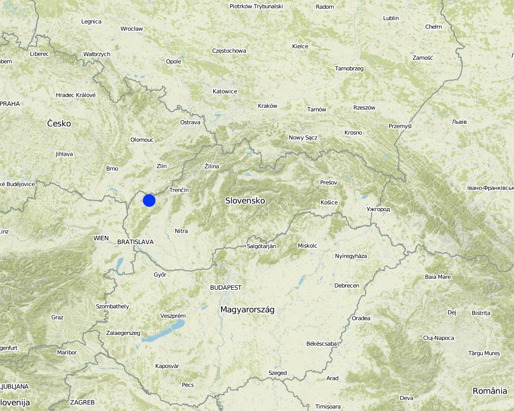
2.5 ປະເທດ / ເຂດ / ສະຖານທີ່ບ່ອນທີ່ແນວທາງໄດ້ຖືກນໍາໃຊ້
ປະເທດ:
ສະໂລວາເກຍ
ພາກພື້ນ / ລັດ / ແຂວງ:
Slovakia
ຂໍ້ມູນເພີ່ມເຕີມຂອງສະຖານທີ່:
Senica / Sobotište
Map
×2.6 ວັນທີເລີ່ມຕົ້ນ ແລະ ສິ້ນສຸດ ການຈັດຕັ້ງປະຕີບັດ ວິທີທາງ
ສະແດງປີຂອງການເລີ່ມຕົ້ນ:
2011
ປີທີ່ສີ້ນສູດ (ຖ້າຢຸດບໍ່ໄດ້ນໍາໃຊ້ ວິທີທາງ):
2012
2.7 ປະເພດຂອງແນວທາງ
- ພາຍໃຕ້ໂຄງການ / ແຜນງານ
2.8 ເປົ້າໝາຍ / ຈຸດປະສົງຫຼັກ ຂອງການຈັດຕັ້ງປະຕິບັດ ວິທີທາງ
The Approach focused mainly on SLM with other activities
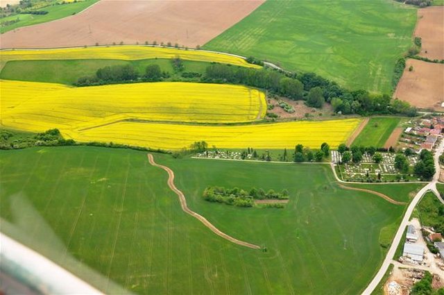
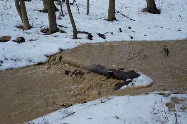
The Sobotište of village was greatly affected in 2011 by floods from storm rainfall. Problems with floods, however, occur regularly, especially at the Teplica and the Sobotišský stream. Some problems have been recorded in farmland and meadows, in places of concentrated runoff during the storm rainfalls, long lasting rainfalls, and snow melting. Floods endanger villages and make severe damage. The goal of the approach is to eliminate damage to healt and properties.
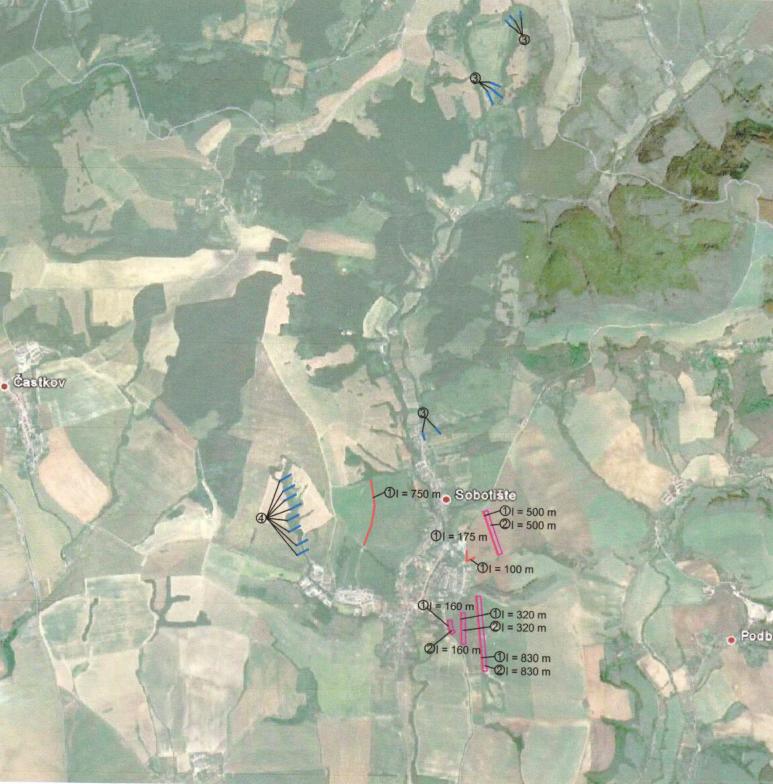
Water retention measures are proposed in the territory of Sobotište, localities of Kubiny, Staré Hory, Javorec, Kaničkov Jarok and Padelky. It is expected that the proposed water retention measures will support the accumulation and infiltration of water into the soil and retard runoff from farmland, meadows, and pastures. With the proper function of measures the surface runoff in farmland will decrease and slow down, and community will not endanger as much as previously.
The SLM Approach addressed the following problems: In general, the main problems within the implementation of projects are mostly legislative regulations that hamper the SLM and the implementation of technologies. The big problem is protection zone of particular rivers connected to administrative and legislative laws and regulations. Some difficulties detected were the execution of permissions for the implementations of methods and technologies that would help to achieve the sustainable land management.
Second problem is land consolidation. The process of the land consolidation is too long to be achieved and accomplished in time. Especially if the public call of the application submission for subsidies needs the consolidation of land to be already solved.
Third, the measures cannot be more expensive than the protected object.
Four, there is lack of money for the purchasing the land in municipalities.
Five, there is very poor law enforcement and recovery of law and claims.
2.9 ເງື່ອນໄຂອໍານວຍ ຫຼື ຂັດຂວາງການປະຕິບັດຂອງເຕັກໂນໂລຢີ / ເຕັກໂນໂລຢີການນໍາໃຊ້ຕາມແນວທາງ
ມີຄວາມສາມາດ / ເຂັ້າເຖິງຊັບພະຍາກອນດ້ານການເງິນ ແລະ ການບໍລິການ
- ເຊື່ອງຊ້ອນ
Treatment through the SLM Approach:
ກ່ຽວກັບກົດໝາຍ (ສິດນໍາໃຊ້ດິນ, ສິດນໍາໃຊ້ນໍ້າ)
- ເຊື່ອງຊ້ອນ
ownership of the land
Treatment through the SLM Approach:
3. ການມີສ່ວນຮ່ວມ ແລະ ບົດບາດຂອງພາກສ່ວນທີ່ກ່ຽວຂ້ອງທີ່ໄດ້ມີສ່ວນຮ່ວມ
3.1 ຜູ້ມີສ່ວນຮ່ວມ ໃນວິທີທາງ ແລະ ພາລະບົດບາດ ຂອງເຂົາເຈົ້າ
- ຜູ້ນໍາໃຊ້ດິນໃນທ້ອງຖິ່ນ / ຊຸມຊົນທ້ອງຖິ່ນ
The approach involved socially and economically disadvantaged ethnicities
- ຜູ້ຊ່ຽວຊານ ການນຄຸ້ມຄອງ ທີ່ດິນແບບຍືນຍົງ / ທີ່ປຶກສາດ້ານກະສິກໍາ
- ພະນັກງານຂັ້ນສູນກາງ (ຜູ້ວາງແຜນ, ຜູ້ສ້າງນະໂຍບາຍ)
3.2 ການມີສ່ວນຮ່ວມຂອງຜູ້ນໍາໃຊ້ທີ່ດິນໃນທ້ອງຖິ່ນ / ຊຸມຊົນທ້ອງຖິ່ນໃນໄລຍະທີ່ແຕກຕ່າງກັນຂອງແນວທາງ
| ການລວບລວມ ເອົາຜູ້ນໍາໃຊ້ດິນ ໃນທ້ອງຖິ່ນ / ຊຸມຊົນທ້ອງຖິ່ນ | ໃຫ້ລະບຸ ຜູ້ໃດທີ່ມີສ່ວນຮ່ວມ ໃນແຕ່ລະກິດຈະກໍາ? | |
|---|---|---|
| ການເລີ່ມຕົ້ນ / ແຮງຈູງໃຈ | ການນໍາໃໍຊ້ເອງ | Government |
| ການວາງແຜນ | ການນໍາໃໍຊ້ເອງ | Government, SLM specialist |
| ການປະຕິບັດ | ການນໍາໃໍຊ້ເອງ | Municipalities, land users |
| ຕິດຕາມກວດກາ / ການປະເມີນຜົນ | ການນໍາໃໍຊ້ເອງ | Municipalities, land users |
| Research | ການບໍ່ປະຕິບັດ |
3.4 ການຕັດສິນໃຈກ່ຽວກັບການຄັດເລືອກເຕັກໂນໂລຢີຂອງການຄຸ້ມຄອງທີ່ດິນແບບຍືນຍົງ / ເຕັກໂນໂລຢີ
ລະບຸ ຄົນທີ່ຕັດສິນໃຈ ກ່ຽວກັບການຄັດເລືອກຂອງ ເຕັກໂນໂລຢີ / ເຕັກໂນໂລຢີ ຈະໄດ້ຮັບການປະຕິບັດ:
- ຜູ້ນໍາໃຊ້ທີ່ດິນຫຼັກ, ການສະໜັບສະໜູນ ໂດຍຜູ້ຊ່ຽວຊານ ການນໍາໃຊ້ທີ່ດິນແບບຍືນຍົງ
ອະທິບາຍ:
Decisions on the method of implementing the SLM Technology were made by mainly by land users supported by SLM specialists
4. ການສະໜັບສະໜູນທາງດ້ານວິຊາການ, ການສ້າງຄວາມສາມາດ, ແລະ ການຈັດການຄວາມຮູ້.
4.1 ການສ້າງຄວາມສາມາດ / ການຝຶກອົບຮົມ
ຜູ້ນໍາໃຊ້ທີ່ດິນ ຫຼື ພາກສ່ວນກ່ຽວຂ້ອງອື່ນໆ ໄດ້ຮັບການຝຶກອົບຮົມບໍ່?
ບໍ່ແມ່ນ
4.2 ການບໍລິການໃຫ້ຄໍາປຶກສາ
ເຮັດຜູ້ໃຊ້ທີ່ດິນມີການເຂົ້າເຖິງການບໍລິການໃຫ້ຄໍາປຶກສາ?
ບໍ່ແມ່ນ
4.3 ສະຖາບັນການສ້າງຄວາມເຂັ້ມແຂງ (ການພັດທະນາອົງການຈັດຕັ້ງ)
ສະຖາບັນ ໄດ້ຮັບການສ້າງຕັ້ງຂື້ນ ຫຼື ໄດ້ຮັບການສ້າງຄວາມເຂັ້ມແຂງ ໂດຍການຈັດຕັ້ງປະຕິບັດ ວິທີທາງບໍ່?
- ບໍ່ມີ
4.4 ຕິດຕາມກວດກາ ແລະ ປະເມີນຜົນ
ການຈັດຕັ້ງປະຕິບັດ ວິທີທາງ ໄດ້ມີການປະເມີນຜົນ ແລະ ຕິດຕາມບໍ?
ບໍ່ແມ່ນ
4.5 ການຄົ້ນຄວ້າ
ນີ້້ແມ່ນສ່ວນໜຶ່ງ ການຄົ້ນຄວ້າ ຂອງວິທີທາງບໍ່?
ແມ່ນ
ລະບຸ ຫົວຂໍ້:
- ເຕັກໂນໂລຢີ
ໃຫ້ຂໍ້ມູນ ເພີ່ມເຕີມ ແລະ ກໍານົດ ຜູ້ໃດເຮັດການຄົ້ນຄວ້າ:
Research was carried out on-farm
5. ການສະໜັບສະໜູນທາງດ້ານການເງິນ ແລະ ອຸປະກອນຈາກພາຍນອກ
5.1 ງົບປະມານປະຈໍາປີ ສໍາລັບວິທີທາງ ຂອງການຄຸ້ມຄອງ ທີ່ດິນແບບຍືນຍົງ
ຖ້າຫາກບໍ່ຮູ້ຈັດງົບປະມານທີ່ແນ່ນອນ ແມ່ນໃຫ້ປະມານເອົາ:
- 10,000-100,000
ຄໍາເຫັນ (ຕົວຢ່າງ: ແຫຼ່ງຂໍ້ມູນຫຼັກ ຂອງການສະໜອງທຶນ / ຜູ້ໃຫ້ທຶນທີ່ສໍາຄັນ):
Approach costs were met by the following donors: government: 100.0%
5.2 ການສະໜັບສະໜູນ ທາງດ້ານການເງິນ / ອຸປະກອນ ສະໜອງໃຫ້ແກ່ຜູ້ນໍາທີ່ດິນ
ຜູ້ນໍາໃຊ້ດິນ ໄດ້ຮັບການສະໜັບສະໜູນ ທາງດ້ານ ການເງິນ / ອຸປະກອນ ໃນການຈັດຕັ້ງປະຕິບັດ ເຕັກໂນໂລຢີບໍ?
ແມ່ນ
ຖ້າແມ່ນ, ໃຫ້ລະບຸປະເພດ (ຫຼາຍ) ຂອງການສະໜັບສະໜູນ, ເງື່ອນໄຂ ແລະ ຜູູ້ສະໜອງ (ຫຼາຍ):
Government funds and subsidies
5.3 ເງິນສົມທົບສໍາລັບການນໍາໃຊ້ສະເພາະປັດໃຈຂາເຂົ້າໃນການຜະລີດກະສິກໍາ (ລວມທັງແຮງງານ)
- ອຸປະກອນ
| ໃຫ້ລະບຸໄດ້ຮັບການສະໜັບສະໜູນປັດໃຈຂາເຂົ້າຫຍັງແດ່ | ທີ່ຂອບເຂດ | ລະບຸ ການອຸດໜູນ |
|---|---|---|
| ເຄື່ອງກົນຈັກ | ງົບປະມານເຕັມສ່ວນ | |
| ເຄື່ອງມື | ງົບປະມານເຕັມສ່ວນ | |
- ກະສິກໍາ
| ໃຫ້ລະບຸໄດ້ຮັບການສະໜັບສະໜູນປັດໃຈຂາເຂົ້າຫຍັງແດ່ | ທີ່ຂອບເຂດ | ລະບຸ ການອຸດໜູນ |
|---|---|---|
| ແນວພັນ, ແກ່ນພັນ | ງົບປະມານເຕັມສ່ວນ | |
| ຝຸ່ນ, ປຸ໋ຍ | ງົບປະມານເຕັມສ່ວນ | |
- ການກໍ່ສ້າງ
| ໃຫ້ລະບຸໄດ້ຮັບການສະໜັບສະໜູນປັດໃຈຂາເຂົ້າຫຍັງແດ່ | ທີ່ຂອບເຂດ | ລະບຸ ການອຸດໜູນ |
|---|---|---|
| ຫີນ | ງົບປະມານເຕັມສ່ວນ | |
| ໄມ້ | ງົບປະມານເຕັມສ່ວນ | |
5.4 ສິນເຊື່ອ
ໄດ້ປ່ອຍສິນເຊື່ອ ສະໜອງໃຫ້ພາຍໃຕ້ ວິທີການສໍາລັບກິດຈະກໍາ ການຄຸ້ມຄອງ ທີ່ດິນແບບຍືນນຍົງບໍ່?
ບໍ່ແມ່ນ
7. ເອກກະສານອ້າງອີງ ແລະ ຂໍ້ມູນການເຊື່ອມໂຍງ
7.1 ວິທີການ / ແຫຼ່ງຂໍ້ມູນ
- ການໄປຢ້ຽມຢາມພາກສະໜາມ, ການສໍາຫຼວດພາກສະໜາມ
- ການສໍາພາດ ຜູ້ນໍາໃຊ້ທີ່ດິນ
ຂໍ້ມູນການເຊື່ອມຕໍ່ ແລະ ເນື້ອໃນ
ຂະຫຍາຍທັງໝົດ ຍຸບທັງໝົດການເຊື່ອມຕໍ່
Level ditches in cropland [ສະໂລວາເກຍ]
Conservation measures for eroded cropland. The technology contains level ditches of various lengths, which are digged along a contour.
- ຜູ້ສັງລວມຂໍ້ມູນ: Zuzana Studvova
Wooden check dams [ສະໂລວາເກຍ]
Small wooden check dams built in erosion rills, grooves or gorges to reduce flood risk.
- ຜູ້ສັງລວມຂໍ້ມູນ: Zuzana Studvova
ເນື້ອໃນ
ບໍ່ມີເນື້ອໃນ