Dugout Sunken Pond with Catchment Treatment [ອິນເດຍ]
- ການສ້າງ:
- ປັບປູງ:
- ຜູ້ສັງລວມຂໍ້ມູນ: Unknown User
- ບັນນາທິການ: –
- ຜູ້ທົບທວນຄືນ: Fabian Ottiger, Alexandra Gavilano
Bandha/ Pokhari (Oriya)
technologies_1475 - ອິນເດຍ
ເບິ່ງພາກສ່ວນ
ຂະຫຍາຍທັງໝົດ ຍຸບທັງໝົດ1. ຂໍ້ມູນທົ່ວໄປ
1.2 ຂໍ້ມູນ ການຕິດຕໍ່ພົວພັນ ຂອງບຸກຄົນທີ່ສໍາຄັນ ແລະ ສະຖາບັນ ທີ່ມີສ່ວນຮ່ວມ ໃນການປະເມີນເອກກະສານ ເຕັກໂນໂລຢີ
ບັນດາຜູ້ຕອບແບບສອບຖາມທີ່ສໍາຄັນ ()
ຜຸ້ຊ່ຽວຊານ ດ້ານການຄຸ້ມຄອງ ທີ່ດິນແບບຍືນຍົງ:
Patnaik Kishore Chandra
ອິນເດຍ
ຜຸ້ຊ່ຽວຊານ ດ້ານການຄຸ້ມຄອງ ທີ່ດິນແບບຍືນຍົງ:
Pradhan Gandhi
ອິນເດຍ
ຜຸ້ຊ່ຽວຊານ ດ້ານການຄຸ້ມຄອງ ທີ່ດິນແບບຍືນຍົງ:
Tripathy Dasarathi
ອິນເດຍ
ຜຸ້ຊ່ຽວຊານ ດ້ານການຄຸ້ມຄອງ ທີ່ດິນແບບຍືນຍົງ:
Panda R.K
Central Soil & Water Conservation Research & Training Institute
ອິນເດຍ
ຜຸ້ຊ່ຽວຊານ ດ້ານການຄຸ້ມຄອງ ທີ່ດິນແບບຍືນຍົງ:
Mohanty K.C
Sahid Laxman Naik Development Society
ອິນເດຍ
ຜຸ້ຊ່ຽວຊານ ດ້ານການຄຸ້ມຄອງ ທີ່ດິນແບບຍືນຍົງ:
Mishra BIJAYALAXMI
IDCWDP
ອິນເດຍ
ຊື່ສະຖາບັນ (ຫຼາຍສະຖາບັນ) ທີ່ອໍານວຍຄວາມສະດວກ ໃນການສ້າງເອກກະສານ / ປະເມີນ ເຕັກໂນໂລຢີ (ຖ້າກ່ຽວຂ້ອງ)
Central Soil & Water Conservation Research & Training Institute - ອິນເດຍຊື່ສະຖາບັນ (ຫຼາຍສະຖາບັນ) ທີ່ອໍານວຍຄວາມສະດວກ ໃນການສ້າງເອກກະສານ / ປະເມີນ ເຕັກໂນໂລຢີ (ຖ້າກ່ຽວຂ້ອງ)
Sahid Laxman Naik Development Society - ອິນເດຍຊື່ສະຖາບັນ (ຫຼາຍສະຖາບັນ) ທີ່ອໍານວຍຄວາມສະດວກ ໃນການສ້າງເອກກະສານ / ປະເມີນ ເຕັກໂນໂລຢີ (ຖ້າກ່ຽວຂ້ອງ)
IDCWDP (IDCWDP) - ອິນເດຍ1.3 ເງື່ອນໄຂ ກ່ຽວກັບ ການນໍາໃຊ້ຂໍ້ມູນເອກະສານ ທີ່ສ້າງຂື້ນ ໂດຍຜ່ານ ອົງການພາບລວມຂອງໂລກ ທາງດ້ານແນວທາງ ແລະ ເຕັກໂນໂລຢີ ຂອງການອານຸລັກ ທໍາມະຊາດ (WOCAT)
ຜູ້ປ້ອນຂໍ້ມູນ ແລະ ບຸກຄົນສຳຄັນ ທີ່ໃຫ້ຂໍ້ມູນ (ຫຼາຍ) ຍິນຍອມ ຕາມເງື່ອນໄຂ ໃນການນຳໃຊ້ຂໍ້ມູນ ເພື່ອສ້າງເປັນເອກກະສານຂອງ WOCAT:
ແມ່ນ
1.5 ແບບສອບຖາມທີ່ອ້າງອີງເຖີງແນວທາງ ການຄຸ້ມຄອງທີ່ດິນແບບຍືນຍົງ (ໄດ້ເຮັດເປັນເອກະສານທີ່ໃຊ້ WOCAT)
PARTICIPATORY APPROACH IN IDCWDP, DANIDA [ອິນເດຍ]
Participatory approach for holistic and intigrated development of the defined area on watershed basis involving all level of stake holders.
- ຜູ້ສັງລວມຂໍ້ມູນ: Srikanta Kumar Parida
2. ການອະທິບາຍ ເຕັກໂນໂລຢີ ຂອງການຄຸ້ມຄອງ ທີ່ດິນແບບຍືນຍົງ
2.1 ຄໍາອະທິບາຍສັ້ນຂອງ ເຕັກໂນໂລຢີ
ການກຳໜົດຄວາມໝາຍ ຂອງເຕັກໂນໂລຢີ:
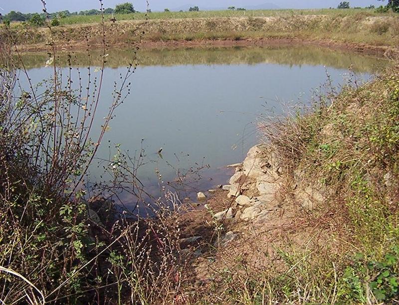
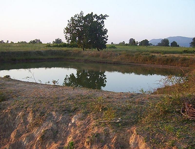
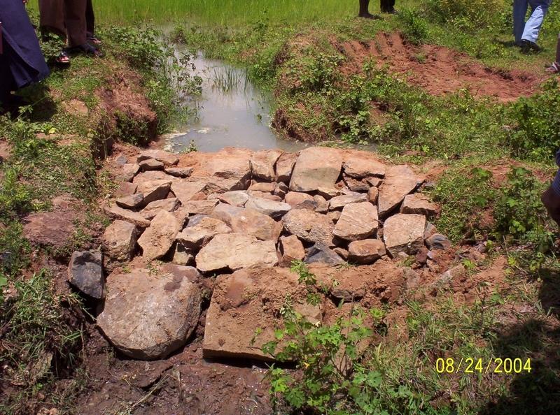
Dugout sunken pond with catchment treatment.
2.2 ການອະທິບາຍ ລາຍລະອຽດ ຂອງເຕັກໂນໂລຢີ
ການພັນລະນາ:
(1) Total size of the project area = 4.75 Ha.
(2) Different structures taken up in the project area are
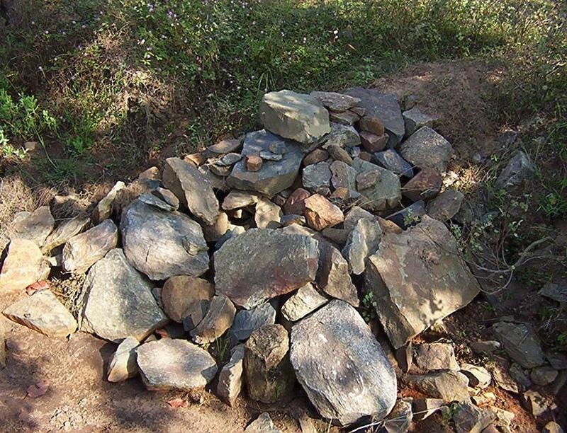
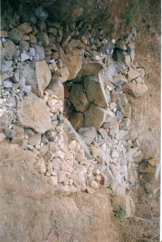
(i) Brushwood check dam- 6 Nos.
(ii) Drop structure- 8 Nos.
(iii) Dugout sunken pond - 1 No.
(3) All the above structures were positioned to ridge to valley treatment
(Ref.QT-6/2.1.2/a)
Purpose of the Technology: 1) Storage of runoff for cattle and human use.
2) Construction of structures to check soil erosion and sand casting.
3) Pisciculture.
Establishment / maintenance activities and inputs: Establishment :-
1) SWC specialist selected sites for dugout sunken pond, layout the design.
2) SWC specialist also selected sites for drop structures, brushwood check
dams in gullied portion of project area with reference to vertical interval
of slope gradient and space between structures.
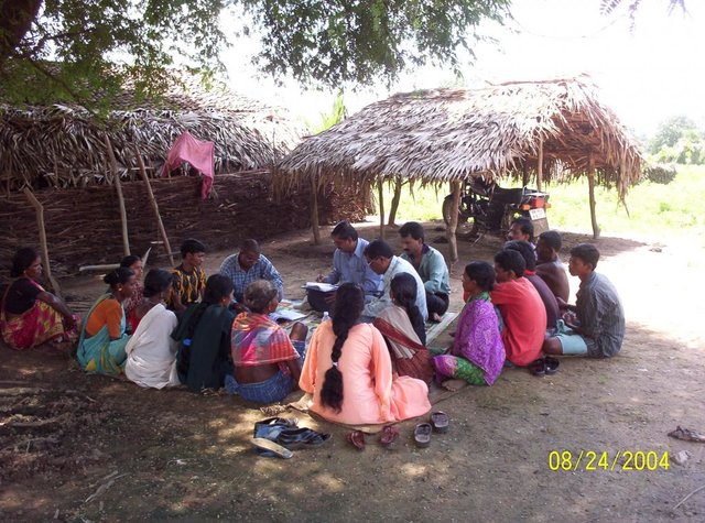
3) The execution of work were done by concerned villagers on payment basis.
4) During execution, 20% of the total cost of the dugout sunken pond was
contributed by the villagers in shape of labour.
5) Training on technical know how imparted to the villagrs during execution
of pond, bund, drop structure and brush wood check dam.
Maintenance:-
1) The dugout sunken pond requires (a) Desiltation once in two years (b)
Repair of earthern bund around inlet and outlet every year.
2) The drop structure & brushwood check dams requires little maintenance when
ever requires.
3) One management group has formed in the same village & funds has been
raised by doing pisciculture in the pond.
4) The management group is taking major reponsibility for its maintenance.
Natural / human environment: (1) Drainage line stablilized (2) Adjuscant area cultivated (3) Users group
formed and pisciculture taken up for the Ist time in the village.
2.3 ຮູບພາບຂອງເຕັກໂນໂລຢີ
ສື່ຮູບພາບ
2.5 ປະເທດ / ເຂດ / ສະຖານທີ່ບ່ອນທີ່ ເຕັກໂນໂລຢີ ໄດ້ຮັບການນໍາໃຊ້ ແລະ ທີ່ຖືກປົກຄຸມດ້ວຍການປະເມີນຜົນ
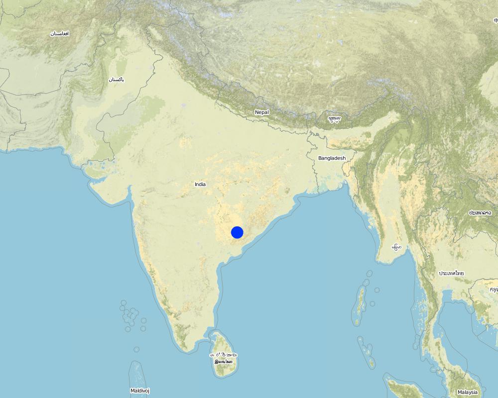
ປະເທດ:
ອິນເດຍ
ພາກພື້ນ / ລັດ / ແຂວງ:
Orissa
ຂໍ້ມູນເພີ່ມເຕີມຂອງສະຖານທີ່:
Orissa/ Malkangiri
ໃຫ້ລະບຸ ການແຜ່ຂະຫຍາຍ ເຕັກໂນໂລຢີ:
- ແຜ່ຂະຫຍາຍຢ່າງໄວວາໃນພື້ນທີ່
ຖ້າຫາກວ່າເຕັກໂນໂລຢີ ໄດ້ກະຈາຍໄປທົ່ວພື້ນທີ່, ໃຫ້ລະບຸເນື້ອທີ່ ທີ່ຖືກປົກຄຸມ (ເປັນ ກິໂລຕາແມັດ):
0.0475
ຖ້າຫາກບໍ່ຮູ້ເນື້ອທີ່ທີ່ແນ່ນອນ, ໃຫ້ລະບຸ ເນື້ອທີ່ໂດຍປະມານ ທີ່ໃກ້ຄຽງ:
- < 0.1 ກິໂລແມັດ2 (10 ເຮັກຕາ)
ຄວາມຄິດເຫັນ:
Total area covered by the SLM Technology is 0.0475 km2.
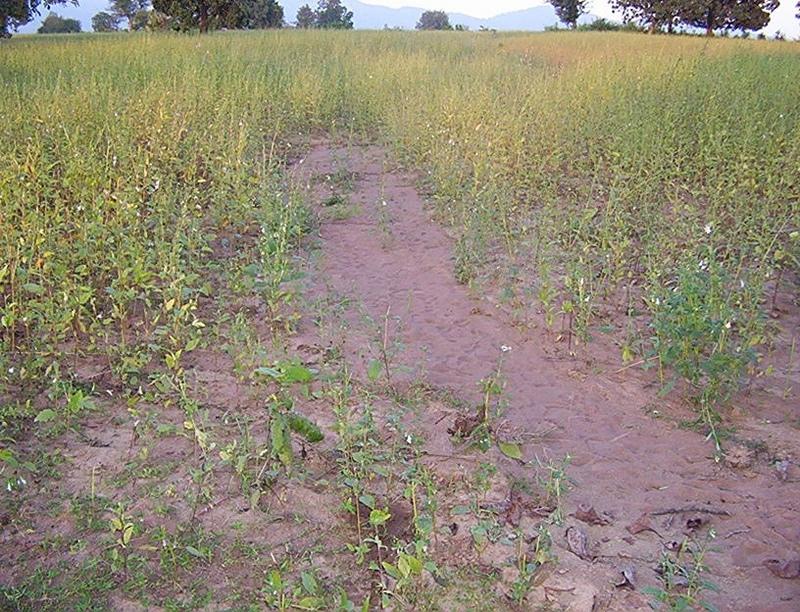
A fellow, understanding, gullied piece ofland selected for the technology which suffers from sand casting and uncertainity of rain.
Map
×2.6 ວັນທີໃນການຈັດຕັ້ງປະຕິບັດ
ຖ້າຫາກວ່າ ບໍ່ຮູ້ຈັກ ປີທີ່ຊັດເຈນ ແມ່ນໃຫ້ປະມານ ວັນທີເອົາ:
- ຕໍ່າກວ່າ 10 ປີ ຜ່ານມາ (ມາເຖິງປະຈຸບັນ)
2.7 ການນໍາສະເໜີ ເຕັກໂນໂລຢີ
ໃຫ້ລະບຸ ເຕັກໂນໂລຢີ ໄດ້ຖືກຈັດຕັ້ງປະຕິບັດຄືແນວໃດ?
- ໂດຍຜ່ານໂຄງການ / ການຊ່ວຍເຫຼືອຈາກພາຍນອກ
ຄວາມຄິດເຫັນ (ປະເພດ ໂຄງການ ແລະ ອື່ນໆ):
National Watershed Development Project for Rainfed Area (NWDPRA)
3. ການໃຈ້ແຍກ ເຕັກໂນໂລຢີ ໃນການຄຸ້ມຄອງ ດິນແບບຍືນຍົງ
3.1 ຈຸດປະສົງຫຼັກ (ຫຼາຍ) ຂອງເຕັກໂນໂລຢີ
- ປັບປຸງ ການຜະລິດ
3.2 ປະເພດການນໍາໃຊ້ທີ່ດິນ ໃນປະຈຸບັນ() ທີ່ເຕັກໂນໂລຢີ ໄດ້ຖືກນໍາໃຊ້
ການນຳໃຊ້ທີ່ດິນ ປະສົມພາຍໃນພື້ນທີ່ດຽວກັນ:
ແມ່ນ
ລະບຸການນຳໃຊ້ທີ່ດິນແບບປະສົມ (ຜົນລະປູກ / ທົ່ງຫຍ້າລ້ຽງສັດ / ຕົ້ນໄມ້):
- ກະສິກໍາແບບປະສົມປະສານ (ລວມທັງ ການລ້ຽງສັດ-ປຸກຝັງ)

ດິນທີ່ປູກພືດ
- ການປູກພືດປະຈໍາປີ
- rice
ຈໍານວນ ລະດູການ ປູກໃນປີໜຶ່ງ:
- 1
ລະບຸ ຊະນິດ:
Longest growing period in days: 150 Longest growing period from month to month: Jul - Nov

ທົ່ງຫຍ້າລ້ຽງສັດ
- cattle
ຄວາມຄິດເຫັນ:
Major land use problems (compiler’s opinion):
1) A fellow, undulating, gullied piece of land.
2) Acute sand casting at the down stream cropland.
3) About 40% of the project area were practicing local paddy which suffers from erratic rainfall.
Major land use problems (land users’ perception): A piece of land which depends upon the mercy of the Rain God for annual production.
3.4 ການສະໜອງນ້ຳ
ການສະໜອງນໍ້າ ໃນພື້ນທີ່ ທີ່ໄດ້ນໍາໃຊ້ ເຕັກໂນໂລຢີ:
- ນໍ້າຝົນ
3.5 ການນໍາໃຊ້ເຕັກໂນໂລຢີ ທີ່ຢູ່ໃນກຸ່ມການຄຸ້ມຄອງ ທີ່ດິນແບບຍືນຍົງ
- ການເກັບກັກນໍ້າ
- ການລ້ຽງເຜີ້ງ, ສັດນໍ້າ, ສັດປີກ, ກະຕ່າຍ, ມ້ອນໃໝ ແລະ ອື່ນໆ.
3.6 ມາດຕະການ ການຄຸ້ມຄອງ ທີ່ດິນແບບຍືນຍົງ ປະກອບດ້ວຍ ເຕັກໂນໂລຢີ

ມາດຕະການໂຄງສ້າງ
- S5: ເຂື່ອນໄຟຟ້າ, ຝາຍເກັບນໍ້າ, ອ່າງ, ໜອງ
ຄວາມຄິດເຫັນ:
Main measures: structural measures
Secondary measures: vegetative measures
Type of vegetative measures: aligned: -contour
3.7 ປະເພດດິນເຊື່ອມໂຊມ ຫຼັກທີ່ໄດ້ນໍາໃຊ້ ເຕັກໂນໂລຢີ

ດິນເຊາະເຈື່ອນ ໂດຍນໍ້າ
- Wt: ການສູນເສຍຊັ້ນໜ້າດິນ / ການເຊາະເຈື່ອນຜິວໜ້າດິນ
- Wg: ການເຊາະເຈື່ອນຮ່ອງນ້ຳ / ຫ້ວຍ
ຄວາມຄິດເຫັນ:
Main type of degradation addressed: Wt: loss of topsoil / surface erosion
Secondary types of degradation addressed: Wg: gully erosion / gullying
Main causes of degradation: other human induced causes (specify) (agricultural causes - Coordination of traditional method of agricultural practices like along the slope, use of long term local varieity of seeds etc.), poverty / wealth (lack of captial)
Secondary causes of degradation: other natural causes (avalanches, volcanic eruptions, mud flows, highly susceptible natural resources, extreme topography, etc.) specify (Erosion problem), education, access to knowledge and support services (lack of knowledge), Common social practices
3.8 ການປ້ອງກັນ, ການຫຼຸດຜ່ອນ, ຫຼືການຟື້ນຟູຂອງການເຊື່ອມໂຊມຂອງດິນ
ໃຫ້ລະບຸ ເປົ້າໝາຍ ເຕັກໂນໂລຢີ ທີ່ພົວພັນ ກັບຄວາມເຊື່ອມໂຊມຂອງດິນ:
- ປ້ອງກັນການເຊື່ອມໂຊມຂອງດິນ
- ຫຼຸດຜ່ອນການເຊື່ອມໂຊມຂອງດິນ
ຄວາມຄິດເຫັນ:
Main goals: mitigation / reduction of land degradation
Secondary goals: prevention of land degradation
4. ຂໍ້ກໍາໜົດ, ກິດຈະກໍາການປະຕິບັດ, ວັດຖຸດິບ, ແລະຄ່າໃຊ້ຈ່າຍ
4.1 ເຕັກນິກ ໃນການແຕ້ມແຜນວາດ ເຕັກໂນໂລຢີ
ຄຸນລັກສະນະ ຂອງເຕັກນິກ (ທີ່ກ່ຽວຂ້ອງ ກັບການແຕ້ມແຜນວາດ ທາງດ້ານເຕັກນີກ):
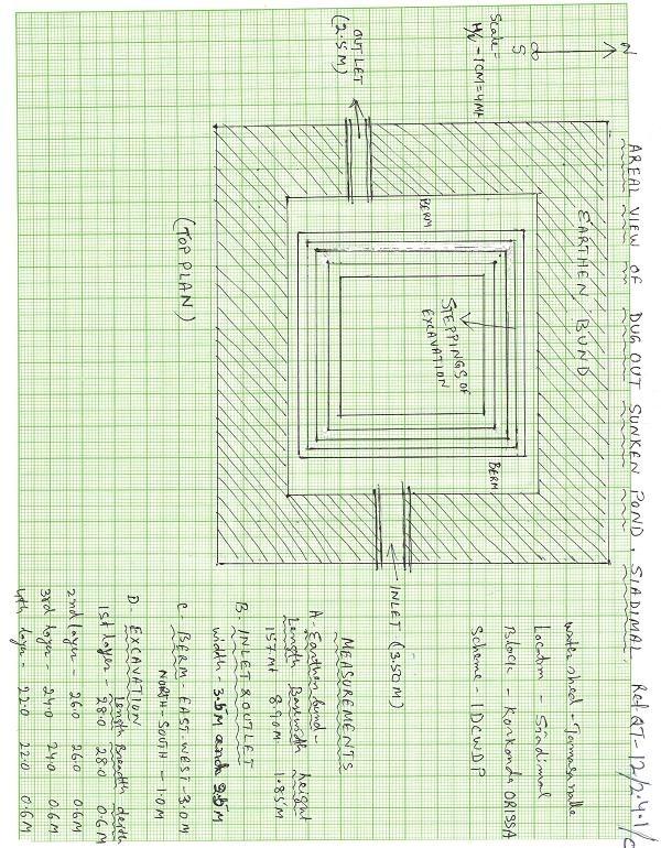
Aerial view of dugout sunken pond
Location: Siadimal, Korkonda. Malkangiri/Orissa/ India
Date: 15.3.2005
Technical knowledge required for field staff / advisors: moderate
Technical knowledge required for land users: moderate
Main technical functions: control of dispersed runoff: retain / trap
Secondary technical functions: reduction of slope angle, water harvesting / increase water supply, Control of sand casting
Aligned: -contour
Vegetative material: G : grass
Vertical interval within rows / strips / blocks (m): 0.15
Width within rows / strips / blocks (m): 0.45
Vegetative measure: In earthern bund slope
Vegetative material: G : grass
Vertical interval within rows / strips / blocks (m): Compact
Width within rows / strips / blocks (m): 3.7
Vegetative measure: Vegetative material: G : grass
Vegetative measure: Vegetative material: G : grass
Vegetative measure: Vegetative material: G : grass
Grass species: Vertivera and local grass slods
Structural measure: Sediment/Sand/Trap/brushwood check dam
Vertical interval between structures (m): 0.6
Spacing between structures (m): 10
Height of bunds/banks/others (m): 0.6
Width of bunds/banks/others (m): 1.5
Length of bunds/banks/others (m): 3
Structural measure: Sediment/Sand/Trap/ drop structure
Vertical interval between structures (m): 9
Spacing between structures (m): 15
Height of bunds/banks/others (m): 1.05
Width of bunds/banks/others (m): 5.3
Length of bunds/banks/others (m): 3
Structural measure: Dam/Pan/Dugout sunken pond
Depth of ditches/pits/dams (m): 0.6
Width of ditches/pits/dams (m): 28/26/24/22
Length of ditches/pits/dams (m): 28/26/24/22
Structural measure: Bund/Trapizoidal
Height of bunds/banks/others (m): 1.85
Width of bunds/banks/others (m): 1.50+8.9/2
Length of bunds/banks/others (m): 157
Construction material (earth): Soil excavated from pond is used to built bund around pond.
Construction material (stone): Inlet and outlet of pond and drop structure are made up of stone
Construction material (wood): Brush wood check dams are made up of wooden poles and bush wood.
Slope (which determines the spacing indicated above): 8%
If the original slope has changed as a result of the Technology, the slope today is: 3%
For water harvesting: the ratio between the area where the harvested water is applied and the total area from which water is collected is: 1:41
Vegetation is used for stabilisation of structures.
ຜູ້ຂຽນ:
Patnaik K.C, Malkangiri, Oriss
4.2 ຂໍ້ມູນທົ່ວໄປກ່ຽວກັບການຄິດໄລ່ປັດໃຈຂາເຂົ້າໃນການຜະລິດ ແລະ ມູນຄ່າອື່ນໆ
ສະກຸນເງິນອື່ນໆ / ປະເທດອື່ນໆ (ລະບຸ):
Rupee
ຖ້າກ່ຽວຂ້ອງ, ໃຫ້ລະບຸອັດຕາແລກປ່ຽນຈາກ USD ເປັນສະກຸນເງິນທ້ອງຖິ່ນ (ເຊັ່ນ: 1 USD = 79.9 Brazilian Real): 1 USD =:
45.0
ລະບຸ ຄ່າຈ້າງ ຄ່າແຮງງານສະເລ່ຍ ຕໍ່ ວັນ:
0.89
4.3 ການສ້າງຕັ້ງກິດຈະກໍາ
| ກິດຈະກໍາ | Timing (season) | |
|---|---|---|
| 1. | Collection grass sods and vertivera slips | beginning of rainy season |
| 2. | Transporting grass sods on established banks | beginning of rainy season |
| 3. | Watering | When dry in Ist. Season |
| 4. | Dugout sunken pond-Surveying | Summer season |
| 5. | Dugout sunken pond- soil excavated from pondage area used in trapizodical bund around leaving inlet & outlet portion. | Summer season |
| 6. | Dugout sunken pond- Collection and transporting stone to inlet & outlet site | Summer season |
| 7. | Dugout sunken pond- construction of inlet & outlet with stone | Summer season |
| 8. | Dugout sunken pond- collection of local grass sods & vertiver slops | Onset of rain |
| 9. | Dugout sunken pond- turfing the bund slopes and planting of vertiver slips in rows at up stream and down steam side of inlet and outlet | On set of rain |
| 10. | Brushwood check dam- surveying | Summer season |
| 11. | Brushwood check dam- collection of wooden poles and brush wood | Summer season |
| 12. | Brushwood check dam- collection of picked up stones | Summer season |
| 13. | Brushwood check dam- fixing of wooden pole, weiving with brush wood, filling up the gaps with picked up stones | Summer season |
| 14. | Brushwood check dam- collection of vertiver slips and planting in upstream and downstream of each structure | On set of rain |
| 15. | Drop structure- surveying | Summer season |
| 16. | Drop structure- collection & transportation of stones to work spot | Summer season |
| 17. | Drop structure- construction of drop structure with stones | Summer season |
| 18. | Drop structure- collection of vertiver slips and planting at up stream and down stream of structure | On set of rain |
4.4 ຕົ້ນທຶນ ແລະ ປັດໄຈຂາເຂົ້າທີ່ຈໍາເປັນໃນຈັດຕັ້ງປະຕິບັດ
| ລະບຸ ປັດໃຈ ນໍາເຂົ້າ ໃນການຜະລີດ | ຫົວໜ່ວຍ | ປະລິມານ | ຕົ້ນທຶນ ຕໍ່ຫົວໜ່ວຍ | ຕົ້ນທຶນທັງໝົດ ຂອງປັດໃຈຂາເຂົ້າ ໃນການຜະລິດ | % ຂອງຕົ້ນທຶນທັງໝົດ ທີ່ຜູ້ນໍາໃຊ້ທີ່ດິນ ໃຊ້ຈ່າຍເອງ | |
|---|---|---|---|---|---|---|
| ແຮງງານ | Labour | ha | 1.0 | 225.0 | 225.0 | 14.0 |
| ອຸປະກອນ | Animal traction | ha | 1.0 | 49.0 | 49.0 | |
| ອຸປະກອນ | Tools | ha | 1.0 | 4.0 | 4.0 | |
| ອື່ນໆ | Royalty charges for stones | ha | 1.0 | 6.0 | 6.0 | |
| ອື່ນໆ | Fishery and feed | ha | 1.0 | 9.0 | 9.0 | |
| ອື່ນໆ | Field bunding | ha | 1.0 | 73.0 | 73.0 | 100.0 |
| ອື່ນໆ | Water way | ha | 1.0 | 6.0 | 6.0 | 100.0 |
| ຕົ້ນທຶນທັງໝົດ ໃນການຈັດຕັ້ງປະຕິບັດ ເຕັກໂນໂລຢີ | 372.0 | |||||
| ຄ່າໃຊ້ຈ່າຍທັງໝົດ ສຳລັບການສ້າງຕັ້ງເຕັກໂນໂລຢີ ເປັນສະກຸນເງີນໂດລາ | 8.27 | |||||
4.5 ບໍາລຸງຮັກສາ / ແຜນຈັດຕັ້ງປະຕິບັດ ກິດຈະກໍາ
| ກິດຈະກໍາ | ໄລຍະເວລາ / ຄວາມຖີ່ | |
|---|---|---|
| 1. | Collecting vertiver slips & grass sods for gap filling | Onset of rain /annual |
| 2. | Collection of grass sods and gap fillling to bund layers | On set of rain/Annualy |
| 3. | Desiltation | Before on set of rain/Biannualy |
4.6 ຄ່າໃຊ້ຈ່າຍ ແລະ ປັດໄຈນໍາເຂົ້າທີ່ຈໍາເປັນສໍາລັບການບໍາລຸງຮັກສາກິດຈະກໍາ / ແຜນປະຕິບັດ (ຕໍ່ປີ)
| ລະບຸ ປັດໃຈ ນໍາເຂົ້າ ໃນການຜະລີດ | ຫົວໜ່ວຍ | ປະລິມານ | ຕົ້ນທຶນ ຕໍ່ຫົວໜ່ວຍ | ຕົ້ນທຶນທັງໝົດ ຂອງປັດໃຈຂາເຂົ້າ ໃນການຜະລິດ | % ຂອງຕົ້ນທຶນທັງໝົດ ທີ່ຜູ້ນໍາໃຊ້ທີ່ດິນ ໃຊ້ຈ່າຍເອງ | |
|---|---|---|---|---|---|---|
| ແຮງງານ | Labour | ha | 1.0 | 18.0 | 18.0 | 100.0 |
| ອື່ນໆ | Field bunding | ha | 1.0 | 2.0 | 2.0 | 100.0 |
| ອື່ນໆ | Water way | ha | 1.0 | 1.0 | 1.0 | 100.0 |
| ຕົ້ນທຶນທັງໝົດ ທີ່ໃຊ້ໃນການບໍາລຸງຮັກສາ ເຕັກໂນໂລຢີ | 21.0 | |||||
| ຄ່າໃຊ້ຈ່າຍທັງໝົດ ສຳລັບການບົວລະບັດຮກສາເຕັກໂນໂລຢີ ເປັນສະກຸນເງີນໂດລາ | 0.47 | |||||
ຄວາມຄິດເຫັນ:
The above calculation is based on the total establishment/ recurring cost both born by the project and land users is devided by the total project area i.e 4.75 ha. To get average hect. cost.
4.7 ປັດໄຈ ທີ່ສໍາຄັນ ທີ່ສົ່ງຜົນກະທົບ ຕໍ່ຄ່າໃຊ້ຈ່າຍ
ໃຫ້ອະທິບາຍ ປັດໃຈ ທີ່ສົ່ງຜົນກະທົບ ຕໍ່ຕົ້ນທຶນ ໃນການຈັດຕັ້ງປະຕິບັດ:
Availability of stone affects the cost from implementing SWC
5. ສະພາບແວດລ້ອມທໍາມະຊາດ ແລະ ມະນຸດ
5.1 ອາກາດ
ປະລິມານນໍ້າຝົນປະຈໍາປີ
- < 250 ມີລິແມັດ
- 251-500 ມີລິແມັດ
- 501-750 ມີລິແມັດ
- 751-1,000 ມີລິແມັດ
- 1,001-1,500 ມີລິແມັດ
- 1,501-2,000 ມີລິແມັດ
- 2,001-3,000 ມີລິແມັດ
- 3,001-4,000 ມີລິແມັດ
- > 4,000 ມີລິແມັດ
ໃຫ້ລະບຸສະເລ່ຍ ປະລິມານນໍ້າຝົນຕົກປະຈໍາປີ ເປັນມິນລິແມັດ (ຖ້າຫາກຮູ້ຈັກ):
1760.00
ເຂດສະພາບອາກາດກະສິກໍາ
- ເຄີ່ງຄວາມຊຸ່ມ
South Eastern Ghat Agro Climatic Zone
5.2 ພູມິປະເທດ
ຄ່າສະເລ່ຍ ຄວາມຄ້ອຍຊັນ:
- ພື້ນທີ່ຮາບພຽງ (0-2%)
- ອ່ອນ (3-5 %)
- ປານກາງ (6-10 %)
- ມ້ວນ (11-15 %)
- ເນີນ(16-30%)
- ໍຊັນ (31-60%)
- ຊັນຫຼາຍ (>60%)
ຮູບແບບຂອງດິນ:
- ພູພຽງ / ທົ່ງພຽງ
- ສັນພູ
- ເປີ້ນພູ
- ເນີນພູ
- ຕີນພູ
- ຮ່ອມພູ
ເຂດລະດັບສູງ:
- 0-100 ແມັດ a.s.l.
- 101-500 ແມັດ a.s.l.
- 501-1,000 ແມັດ a.s.l.
- 1,001-1,500 ແມັດ a.s.l.
- 1,501-2,000 ແມັດ a.s.l.
- 2,001-2,500 ແມັດ a.s.l.
- 2,501-3,000 ແມັດ a.s.l.
- 3,001-4,000 ແມັດ a.s.l.
- > 4,000 ແມັດ a.s.l.
ຄຳເຫັນ ແລະ ຂໍ້ມູນສະເພາະ ເພີ່ມເຕີມ ກ່ຽວກັບ ພູມີປະເທດ:
Altitudinal zone: 101-500 m a.s.l. (423 m a.s.l.)
Landforms: Plateau/plains (2-7% slope)
5.3 ດິນ
ຄວາມເລິກ ຂອງດິນສະເລ່ຍ:
- ຕື້ນຫຼາຍ (0-20 ຊັງຕີແມັດ)
- ຕື້ນ (21-50 ຊຕມ)
- ເລີກປານກາງ (51-80 ຊຕມ)
- ເລິກ (81-120 ຊມ)
- ເລິກຫຼາຍ (> 120 cm)
ເນື້ອດິນ (ໜ້າດິນ):
- ປານກາງ (ດິນໜຽວ, ດິນໂຄນ)
ຊັ້ນອິນຊີວັດຖຸ ເທິງໜ້າດິນ:
- ປານກາງ (1-3 %)
ຖ້າເປັນໄປໄດ້ ແມ່ນໃຫ້ຕິດຄັດ ການພັນລະນາດິນ ຫຼື ຂໍ້ມູນສະເພາະຂອງດິນ, ຕົວຢ່າງ, ຄຸນລັກສະນະ ປະເພດຂອງດິນ, ຄ່າຄວາມເປັນກົດ / ເປັນດ່າງຂອງດິນ, ສານອາຫານ, ດິນເຄັມ ແລະ ອື່ນໆ.
Soil fertility: Medium
Soil drainage/infiltration: Good
Soil water storage capacity: Medium
5.6 ຄຸນລັກສະນະ ຂອງຜູ້ນໍາໃຊ້ທີ່ດິນ ທີ່ໄດ້ນໍາໃຊ້ເຕັກໂນໂລຢີ
ລາຍຮັບ ທີ່ບໍ່ໄດ້ມາຈາກ ການຜະລິດ ກະສິກໍາ:
- 10-50 % ຂອງລາຍຮັບທັງໝົດ
ລະດັບຄວາມຮັ່ງມີ:
- ທຸກຍາກ
- ສະເລ່ຍ
ລະດັບ ການຫັນເປັນກົນຈັກ:
- ການໃຊ້ແຮງງານຄົນ
- ສັດລາກແກ່
ໃຫ້ລະບຸ ຄຸນລັກສະນະ ຂອງຜູ້ນໍາໃຊ້ທີ່ດິນ:
Population density: < 10 persons/km2
Annual population growth: < 0.5%
30% of the land users are average wealthy and own 60% of the land.
70% of the land users are poor and own 40% of the land.
Off-farm income specification: Land users from SWC technology area proctise contour plough, line sowing and using HYV paddy have increased their income significantly.
Level of mechanization: Manual labour and aniaml traction (bullock plough, both ranked 1)
Market orientation of production system: Pisciculture (Selling at village level)
5.7 ເນື້ອທີ່ສະເລ່ຍຂອງດິນ ທີ່ຜູ້ນຳໃຊ້ທີ່ດິນ ໃຊ້ເຮັດເຕັກໂນໂລຢີ
- <0.5 ເຮັກຕາ
- 0.5-1 ເຮັກຕາ
- 1-2 ເຮັກຕາ
- 2-5 ເຮັກຕາ
- 5-15 ເຮັກຕາ
- 15-50 ເຮັກຕາ
- 50-100 ເຮັກຕາ
- 100-500 ເຮັກຕາ
- 500-1,000 ເຮັກຕາ
- 1,000-10,000 ເຮັກຕາ
- > 10,000 ເຮັກຕາ
5.8 ເຈົ້າຂອງທີ່ດິນ, ສິດໃຊ້ທີ່ດິນ, ແລະ ສິດທິການນໍາໃຊ້ນໍ້າ
ເຈົ້າຂອງດິນ:
- ຊຸມຊົນ / ບ້ານ
ສິດທິ ໃນການນໍາໃຊ້ທີ່ດິນ:
- ເປີດກວ້າງ (ບໍ່ມີການຈັດຕັ້ງ)
6. ຜົນກະທົບ ແລະ ລາຍງານສະຫຼຸບ
6.1 ການສະແດງຜົນກະທົບ ພາຍໃນພື້ນທີ່ ທີ່ໄດ້ຈັດຕັ້ງປະຕິບັດ ເຕັກໂນໂລຢີ
ຜົນກະທົບທາງເສດຖະກິດສັງຄົມ
ການຜະລິດ
ການຜະລິດພືດ
ຄວາມໜາແໜ້ນ ຂອງຜົນຜະລິດ
ຄວາມຄິດເຫັນ / ລະບຸແຈ້ງ:
Fish add to their income
ເນື້ອທີ່ການຜະລິດ
ຄວາມຄິດເຫັນ / ລະບຸແຈ້ງ:
Closure of land by pondage area
ມີນໍ້າ ແລະ ຄຸນນະພາບ
ມີນໍ້າ ໃຫ້ສັດລ້ຽງ
ຄວາມຄິດເຫັນ / ລະບຸແຈ້ງ:
Pisciculture support to live stock, dirnking water for cattle
ຜົນກະທົບດ້ານວັດທະນາທໍາສັງຄົມ
ສະຖາບັນ ການຈັດຕັ້ງຊຸມຊົນ
ຄວາມຄິດເຫັນ / ລະບຸແຈ້ງ:
Management group formed and strengthened due to continurous income from pisciculture.
ຄວາມຮູ້ກ່ຽວກັບ ການຄຸ້ມຄອງ ທີ່ດິນແບບຍືນຍົງ / ການເຊື່ອມໂຊມຂອງດິນ
ຄວາມຄິດເຫັນ / ລະບຸແຈ້ງ:
Training conducted
Linkage with other institutions
ຄວາມຄິດເຫັນ / ລະບຸແຈ້ງ:
Due to different activities in the pond linkage to other institution has increased like Horticulture, Fishery etc.
ຜົນກະທົບຕໍ່ລະບົບນິເວດ
ວົງຈອນນໍ້າ / ນໍ້າ
ການໄຫຼ ຂອງນໍ້າໜ້າດິນ
ປະລິມານ ກ່ອນການຈັດຕັ້ງປະຕິບັດ ການຄຸ້ມຄອງ ທີ່ດິນແບບຍືນຍົງ:
90
ປະລີມານ ຫຼັງການຈັດຕັ້ງປະຕິບັດ ການຄຸ້ມຄອງ ທີ່ດິນແບບຍືນຍົງ:
40
ການລະບາຍນໍ້າ
ດິນ
ຄວາມຊຸ່ມຂອງດິນ
ຄວາມຄິດເຫັນ / ລະບຸແຈ້ງ:
Due to water storage
ການສູນເສຍດິນ
ປະລິມານ ກ່ອນການຈັດຕັ້ງປະຕິບັດ ການຄຸ້ມຄອງ ທີ່ດິນແບບຍືນຍົງ:
87
ປະລີມານ ຫຼັງການຈັດຕັ້ງປະຕິບັດ ການຄຸ້ມຄອງ ທີ່ດິນແບບຍືນຍົງ:
45
ຜົນກະທົບຕໍ່ລະບົບນິເວດອື່ນໆ
Biodiversity
6.2 ຜົນກະທົບທາງອ້ອມ ຈາກການນໍາໃຊ້ເຕັກໂນໂລຢີ
ການທັບຖົມ ຂອງດິນຕະກອນ ຢູ່ເຂດລຸ່ມນໍ້າ
Soil moisture regime
6.4 ການວິເຄາະຕົ້ນທຶນ ແລະ ຜົນປະໂຫຍດ
ຈະເຮັດປະໂຫຍດເພື່ອປຽບທຽບກັບຄ່າໃຊ້ຈ່າຍກັບສິ່ງກໍ່ສ້າງ (ຈາກທັດສະນະຂອງຜູ້ນຳໃຊ້ທີ່ດິນ) ໄດ້ແນວໃດ?
ຜົນຕອບແທນ ໃນໄລຍະສັ້ນ:
ຜົນກະທົບທາງບວກເລັກນ້ອຍ
ຜົນຕອບແທນ ໃນໄລຍະຍາວ:
ຜົນກະທົບທາງບວກ
ຈະໄດ້ຮັບຜົນປະໂຫຍດເມື່ອປຽບທຽບກັບ / ຄ່າໃຊ້ຈ່າຍໃນການບຳລຸງຮັກສາທີເ່ກີດຂື້ນອິກ (ຈາກທັດສະນະຄະຕິຂອງຜູ້ນຳໃຊ້ທີ່ດິນ) ໄດ້ແນວໃດ?
ຜົນຕອບແທນ ໃນໄລຍະສັ້ນ:
ປານກາງ
ຜົນຕອບແທນ ໃນໄລຍະຍາວ:
ປານກາງ
6.5 ການປັບຕົວຮັບເອົາເຕັກໂນໂລຢີ
ທັງໝົດນັ້ນ ແມ່ນໃຜ ໄດ້ປັບຕົວເຂົ້າ ໃນການນໍາໃຊ້ ເຕັກໂນໂລຢີ, ມີຈັກຄົນ ທີ່ສາມາດເຮັດເອງໄດ້, ຕົວຢ່າງ, ປາດສະຈາກ ການຊ່ວຍເຫຼືອ ທາງດ້ານອຸປະກອນ / ການຈ່າຍເປັນເງິນ?
- 91-100%
ຄວາມຄິດເຫັນ:
100% of land user families have adopted the Technology without any external material support
19 land user families have adopted the Technology without any external material support
Comments on spontaneous adoption: survey results
There is a moderate trend towards spontaneous adoption of the Technology
Comments on adoption trend: If the community find the technology is low cost to teke up and gets eye catching benefits, then the treand of adoption is good.
6.7 ຈຸດແຂງ / ຂໍ້ດີ / ໂອກາດ ໃນການນໍາໃຊ້ ເຕັກໂນໂລຢີ
| ຈຸດແຂງ / ຂໍ້ດີ / ໂອກາດໃນການນໍາໃຊ້ທີ່ດິນ |
|---|
|
Water problem for human and cattle solved How can they be sustained / enhanced? Regular maintenance of pond needed |
|
Damage of crops reduced by construction of series of structures How can they be sustained / enhanced? More field bunding, vegetative cover should be imparted. |
|
Users group brings villagers closure How can they be sustained / enhanced? Manageent group to be reorganised annuly |
| ຈຸດແຂງ / ຈຸດດີ / ໂອກາດ ຈາກທັດສະນະຂອງຜູ້ປ້ອນຂໍ້ມູນ ຫຼື ບຸກຄົນສຳຄັນ |
|---|
|
Water scarcity of the area partly solved How can they be sustained / enhanced? Regular desilting shound be done. |
|
Heavy sand casting and soil loss controled How can they be sustained / enhanced? More vegetative cover required for catchement area |
|
Crop production increased in the project area How can they be sustained / enhanced? Should be replicated by the people. |
|
Pisciculture added extra income to the villagers How can they be sustained / enhanced? Hybrid fingerlings to be adopted |
6.8 ຈຸດອ່ອນ / ຂໍ້ເສຍ / ຄວາມສ່ຽງ ໃນການນໍາໃຊ້ ເຕັກໂນໂລຢີ ແລະ ວິທີການແກ້ໄຂບັນຫາ
| ຈຸດອ່ອນ/ຂໍ້ບົກຜ່ອງ/ຄວາມສ່ຽງ ຈາກທັດສະນະຂອງຜູ້ປ້ອນຂໍ້ມູນ ຫຼື ບຸກຄົນສຳຄັນ | ມີວິທີການແກ້ໄຂຄືແນວໃດ? |
|---|---|
| Sand casting could not be checked fully | By full vegetative cover and more structural measures it can be checked. |
| Sediment deposit in down stream area decreased | The loss can be over come by increasing crop yield. |
7. ເອກະສານອ້າງອີງ ແລະ ການເຊື່ອມຕໍ່
7.1 ວິທີການ / ແຫຼ່ງຂໍ້ມູນ
7.2 ເອກກະສານອ້າງອີງທີ່ເປັນບົດລາຍງານ
ຫົວຂໍ້, ຜູ້ຂຽນ, ປີ, ISBN:
Watershed Survey Report
ມີຢູ່ໃສ?ມູນຄ່າເທົ່າໃດ?
Director of Soil Conservation, Orissa, Bhubaneswar
ຫົວຂໍ້, ຜູ້ຂຽນ, ປີ, ISBN:
Plan and Estimate
ມີຢູ່ໃສ?ມູນຄ່າເທົ່າໃດ?
-do-
ຂໍ້ມູນການເຊື່ອມຕໍ່ ແລະ ເນື້ອໃນ
ຂະຫຍາຍທັງໝົດ ຍຸບທັງໝົດການເຊື່ອມຕໍ່
PARTICIPATORY APPROACH IN IDCWDP, DANIDA [ອິນເດຍ]
Participatory approach for holistic and intigrated development of the defined area on watershed basis involving all level of stake holders.
- ຜູ້ສັງລວມຂໍ້ມູນ: Srikanta Kumar Parida
ເນື້ອໃນ
ບໍ່ມີເນື້ອໃນ