Use of sediment retention fibre rolls (SRFR) and erosion blankets to stabilise slopes after fire [ອາຟິກກາໃຕ້]
- ການສ້າງ:
- ປັບປູງ:
- ຜູ້ສັງລວມຂໍ້ມູນ: Dirk Pretorius
- ບັນນາທິການ: –
- ຜູ້ທົບທວນຄືນ: William Critchley, Rima Mekdaschi Studer
Wood wool rolls/fibre rolls
technologies_6000 - ອາຟິກກາໃຕ້
ເບິ່ງພາກສ່ວນ
ຂະຫຍາຍທັງໝົດ ຍຸບທັງໝົດ1. ຂໍ້ມູນທົ່ວໄປ
1.2 ຂໍ້ມູນ ການຕິດຕໍ່ພົວພັນ ຂອງບຸກຄົນທີ່ສໍາຄັນ ແລະ ສະຖາບັນ ທີ່ມີສ່ວນຮ່ວມ ໃນການປະເມີນເອກກະສານ ເຕັກໂນໂລຢີ
ບັນດາຜູ້ຕອບແບບສອບຖາມທີ່ສໍາຄັນ ()
ຜຸ້ຊ່ຽວຊານ ດ້ານການຄຸ້ມຄອງ ທີ່ດິນແບບຍືນຍົງ:
Buckle Jacob
Hive Carbon
ອາຟິກກາໃຕ້
ຊື່ໂຄງການ ທີ່ອໍານວຍຄວາມສະດວກ ໃນການສ້າງເອກກະສານ/ປະເມີນ ເຕັກໂນໂລຢີ (ຖ້າກ່ຽວຂ້ອງ)
Working for Water Programme, South Africa (WfW)ຊື່ສະຖາບັນ (ຫຼາຍສະຖາບັນ) ທີ່ອໍານວຍຄວາມສະດວກ ໃນການສ້າງເອກກະສານ / ປະເມີນ ເຕັກໂນໂລຢີ (ຖ້າກ່ຽວຂ້ອງ)
Department of Environmental Affairs South Africa (DEA) - ອາຟິກກາໃຕ້1.3 ເງື່ອນໄຂ ກ່ຽວກັບ ການນໍາໃຊ້ຂໍ້ມູນເອກະສານ ທີ່ສ້າງຂື້ນ ໂດຍຜ່ານ ອົງການພາບລວມຂອງໂລກ ທາງດ້ານແນວທາງ ແລະ ເຕັກໂນໂລຢີ ຂອງການອານຸລັກ ທໍາມະຊາດ (WOCAT)
ຜູ້ປ້ອນຂໍ້ມູນ ແລະ ບຸກຄົນສຳຄັນ ທີ່ໃຫ້ຂໍ້ມູນ (ຫຼາຍ) ຍິນຍອມ ຕາມເງື່ອນໄຂ ໃນການນຳໃຊ້ຂໍ້ມູນ ເພື່ອສ້າງເປັນເອກກະສານຂອງ WOCAT:
ແມ່ນ
1.4 ແຈ້ງການວ່າ ດ້ວຍຄວາມຍືນຍົງຂອງ ເຕັກໂນໂລຢີ
ການນໍາໃຊ້ ເຕັກໂນໂລຢີ ດັ່ງກ່າວໄດ້ອະທິບາຍ ເຖິງບັນຫາ ກ່ຽວກັບ ການເຊື່ອມໂຊມຂອງດິນບໍ? ຖ້າບໍ່ດັ່ງນັ້ນ ມັນບໍ່ສາມາດ ຢັ້ງຢືນໄດ້ວ່າ ເປັນເຕັກໂນໂລຊີ ໃນການຄຸ້ມຄອງ ທີ່ດິນແບບຍືນຍົງ? :
ບໍ່ແມ່ນ
1.5 ແບບສອບຖາມທີ່ອ້າງອີງເຖີງແນວທາງ ການຄຸ້ມຄອງທີ່ດິນແບບຍືນຍົງ (ໄດ້ເຮັດເປັນເອກະສານທີ່ໃຊ້ WOCAT)
Working for Water [ອາຟິກກາໃຕ້]
Government funded restoration/rehabilitation initiative as part of Working for Water project. Aim was to eradicate alien invasive.
- ຜູ້ສັງລວມຂໍ້ມູນ: Klaus Kellner
2. ການອະທິບາຍ ເຕັກໂນໂລຢີ ຂອງການຄຸ້ມຄອງ ທີ່ດິນແບບຍືນຍົງ
2.1 ຄໍາອະທິບາຍສັ້ນຂອງ ເຕັກໂນໂລຢີ
ການກຳໜົດຄວາມໝາຍ ຂອງເຕັກໂນໂລຢີ:
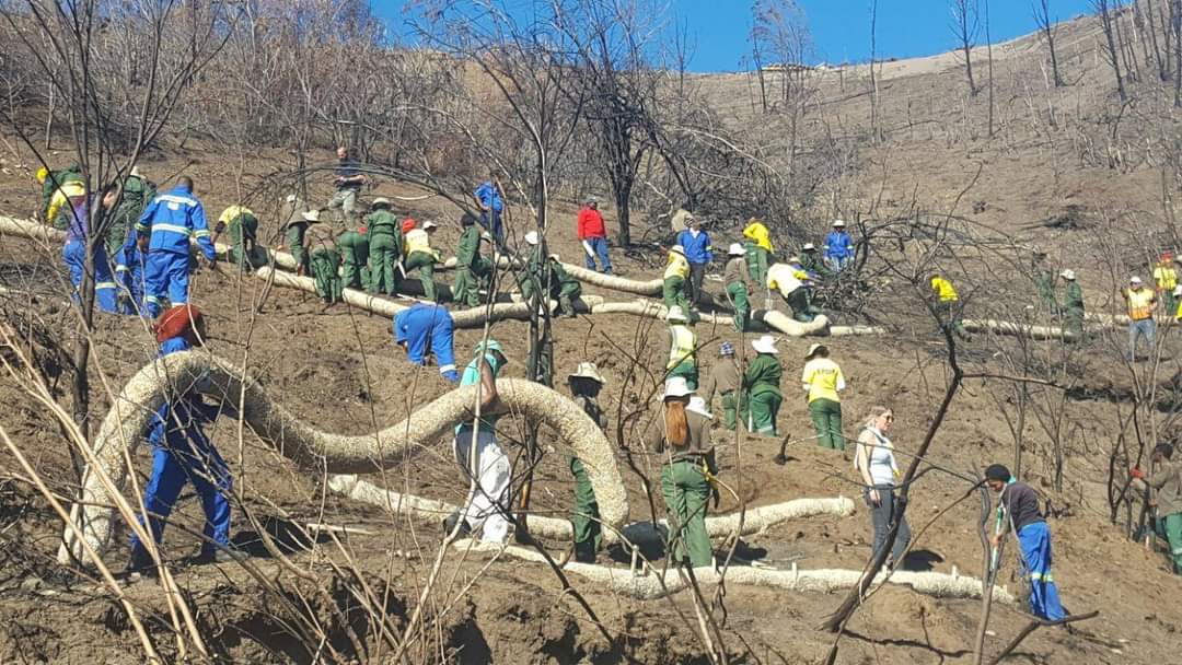
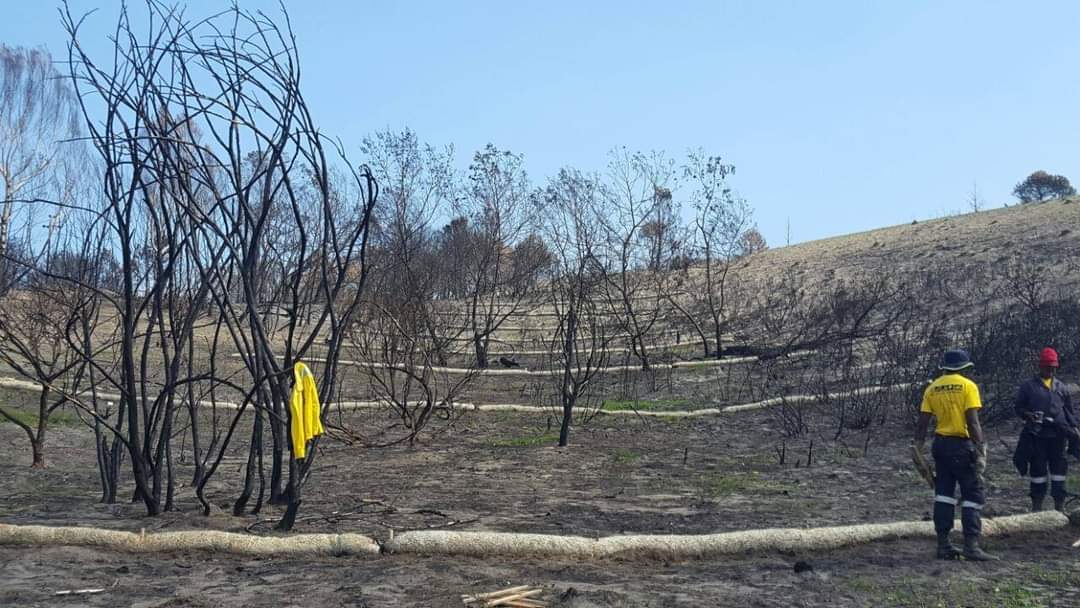
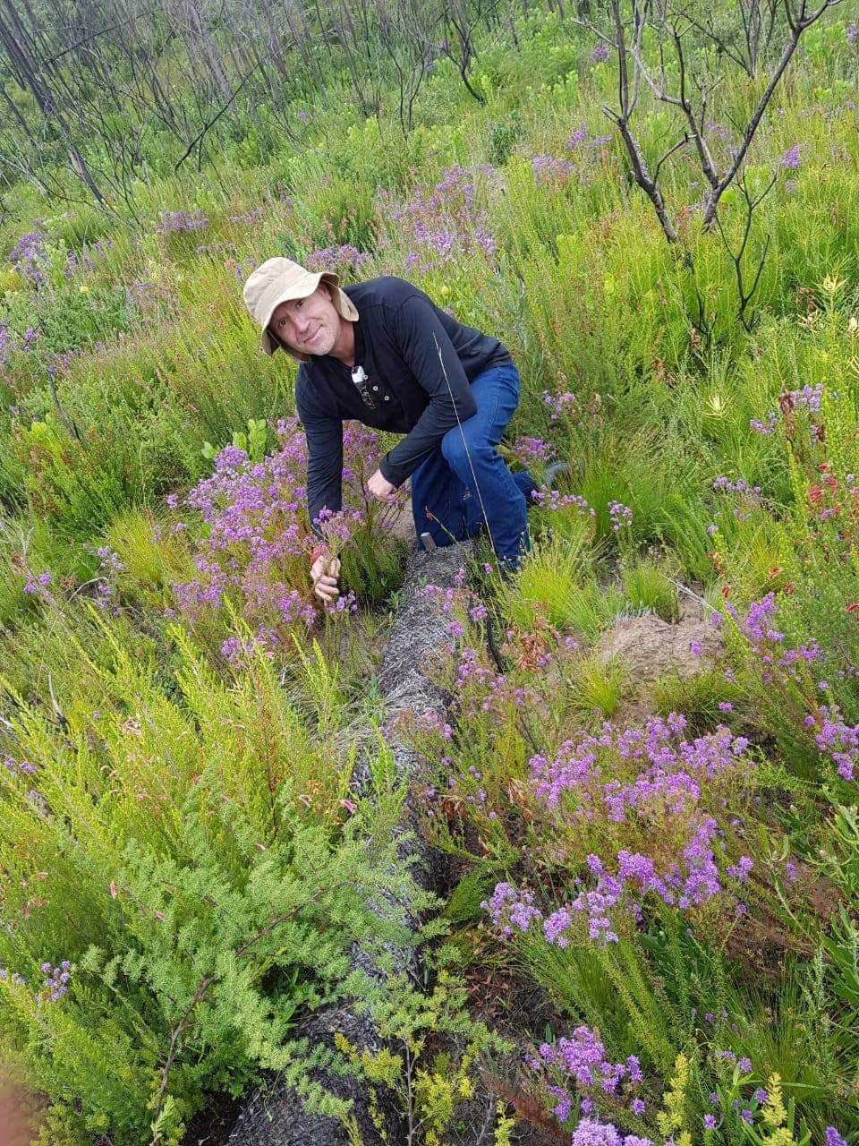
Sediment retention fibre rolls (SRFR) and erosion blankets were deployed to stabilise steep slopes after vegetation cover was destroyed by fire, near the town of Knysna in the Western Cape Province, South Africa
2.2 ການອະທິບາຍ ລາຍລະອຽດ ຂອງເຕັກໂນໂລຢີ
ການພັນລະນາ:
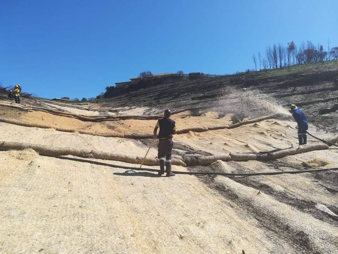
Sediment retention fibre rolls (SRFR) and erosion blankets were deployed near the town of Knysna in the Western Cape Province of South Africa to stabilise slopes after vegetation was destroyed by wildfires in 2017. The predominant geology is quartzite, shale, schist, conglomerate and dune sand. The soils of this area are generally acidic and nutrient-poor occurring, on moderate to steep slopes, ranging from 5 m to 1,220 m above sea level. The area receives summer and winter rainfall with an annual average of around 650 to 700 mm. The Knysna fires were the worst wildfire disaster in South African history (more than 21 000 ha were affected – destroying more than 800 buildings, 5000 ha of forest plantations and claiming the lives of seven people). Investigations reported that its severity was caused by a cocktail of factors, including drought, low atmospheric humidity, strong warm Bergwind conditions and abundant biomass. After the fires, the lack of vegetation cover on steep sandy slopes in the affected areas posed an immediate danger of erosion and landslides to downstream catchments, ravines and man-made infrastructure. Areas with high infestations of invasive alien plants required active re-establishment of indigenous plants and the removal of alien seedlings (popular and aspen) after germination. It is estimated that 53 km of wood fibre rolls (or "sausages") and 54 000 m² of erosion blankets (Woodwool fibre filled) have been installed on post-fire erosion mitigation projects. Furthermore hydroseeding was carried out with the annual grass "teff" (Eragrostis tef) to serve as an interim (annual grass) soil stabiliser. This will be replaced by indigenous plant growth in time. The project was implemented in the following stages:
1.Identification of priority areas where infrastructure was threatened (using GIS modelling)
2.Acquisition of restoration materials – SRFR and erosion blankets produced through secondary industries created through the removal of invasive alien plants (popular and aspen)
3.Training of local community members on implementation of restoration measures
4.Removal of all burnt woody material
5.Introduction of indigenous seed
6.Installation of erosion control blankets or hydroseeding (seeding using a slurry of seed and mulch)
7.Installation of SRFR
8.As part of maintenance, removal of invasive alien vegetation seedlings
2.3 ຮູບພາບຂອງເຕັກໂນໂລຢີ
ສື່ຮູບພາບ
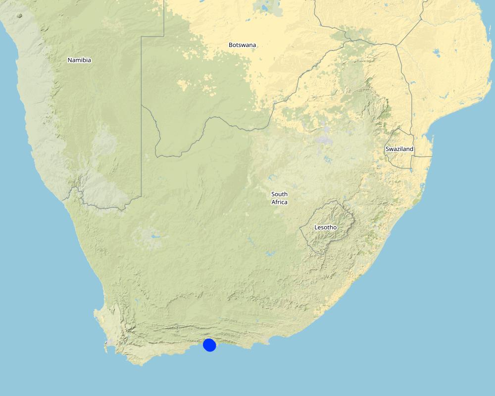
2.5 ປະເທດ / ເຂດ / ສະຖານທີ່ບ່ອນທີ່ ເຕັກໂນໂລຢີ ໄດ້ຮັບການນໍາໃຊ້ ແລະ ທີ່ຖືກປົກຄຸມດ້ວຍການປະເມີນຜົນ
ປະເທດ:
ອາຟິກກາໃຕ້
ພາກພື້ນ / ລັດ / ແຂວງ:
Western Cape
ໃຫ້ລະບຸ ການແຜ່ຂະຫຍາຍ ເຕັກໂນໂລຢີ:
- ແຜ່ຂະຫຍາຍຢ່າງໄວວາໃນພື້ນທີ່
ຖ້າຫາກບໍ່ຮູ້ເນື້ອທີ່ທີ່ແນ່ນອນ, ໃຫ້ລະບຸ ເນື້ອທີ່ໂດຍປະມານ ທີ່ໃກ້ຄຽງ:
- 10-100 ກມ 2
ສ່ວນຫຼາຍສະຖານທີ່ຕັ້ງຂອງເຕັກໂນໂລຢີ ແມ່ນ ຢູ່ໃນເຂດພື້ນທີ່ສະຫງວນບໍ?
ບໍ່ແມ່ນ
Map
×2.6 ວັນທີໃນການຈັດຕັ້ງປະຕິບັດ
ໃຫ້ລະບຸປີ ໃນການຈັດຕັ້ງປະຕິບັດ:
2018
2.7 ການນໍາສະເໜີ ເຕັກໂນໂລຢີ
ໃຫ້ລະບຸ ເຕັກໂນໂລຢີ ໄດ້ຖືກຈັດຕັ້ງປະຕິບັດຄືແນວໃດ?
- ໂດຍຜ່ານໂຄງການ / ການຊ່ວຍເຫຼືອຈາກພາຍນອກ
3. ການໃຈ້ແຍກ ເຕັກໂນໂລຢີ ໃນການຄຸ້ມຄອງ ດິນແບບຍືນຍົງ
3.1 ຈຸດປະສົງຫຼັກ (ຫຼາຍ) ຂອງເຕັກໂນໂລຢີ
- ຫຼຸດຜ່ອນ, ປ້ອງກັນ, ຟື້ນຟູ ການເຊື່ອມໂຊມຂອງດິນ
- ການອະນຸລັກ ລະບົບນິເວດ
- ປົກປັກຮັກສານໍ້າ / ນໍ້າພື້ນທີ່ - ປະສົມປະສານກັບ ເຕັກໂນໂລຢີອື່ນໆ
- ປົກປັກຮັກສາ / ການປັບປຸງຊີວະນາໆພັນ
- ຫຼຸດຜ່ອນຄວາມສ່ຽງ ທາງໄພພິບັດທໍາມະຊາດ
3.2 ປະເພດການນໍາໃຊ້ທີ່ດິນ ໃນປະຈຸບັນ() ທີ່ເຕັກໂນໂລຢີ ໄດ້ຖືກນໍາໃຊ້

ປ່າໄມ້ / ປ່າ
- (ເຄິ່ງ) ປ່າໄມ້ທໍາມະຊາດ / ປ່າປູກໄມ້
(ເຄີ່ງ) ປ່າທໍາມະຊາດ / ປ່າປູກ: ລະບຸປະເພດການຄຸ້ມຄອງ:
- ການນຳໃຊ້ເຄື່ອງປ່າຂອງດົງ
ຕົ້ນໄມ້ທີ່ຖືກລະບຸຢູ່ຂ້າງເທິງ ເປັນປ່າຜັດປ່ຽນໃບ ຫລື ປ່າດົງດິບ?
- ປ່າດົງດິບ
ຜົນຜະລິດ ແລະ ການບໍລິການ:
- ປ້ອງກັນ ການຄຸກຄາມ ທາງທໍາມະຊາດ

ການຕັ້ງຖິ່ນຖານ, ພື້ນຖານໂຄງລ່າງ
- ການຕັ້ງຖິ່ນຖານ, ອາຄານ

ທິດທາງໄຫຼຂອງນໍ້າ, ນໍ້າ, ດິນທາມ
- ທໍ່ລະບາຍນໍ້າ, ທິດທາງນໍ້າ
3.3 ການນຳໃຊ້ທີ່ດິນ ມີການປ່ຽນແປງຍ້ອນການຈັດຕັ້ງທົດລອງເຕັກໂນໂລຢີ ແມ່ນບໍ່?
ການນຳໃຊ້ທີ່ດິນ ມີການປ່ຽນແປງຍ້ອນການຈັດຕັ້ງທົດລອງເຕັກໂນໂລຢີ ແມ່ນບໍ່?
- ບໍ່ (ຕໍ່ເໜືອງກັບ ຄຳຖາມ 3.4)
3.4 ການສະໜອງນ້ຳ
ການສະໜອງນໍ້າ ໃນພື້ນທີ່ ທີ່ໄດ້ນໍາໃຊ້ ເຕັກໂນໂລຢີ:
- ນໍ້າຝົນ
3.5 ການນໍາໃຊ້ເຕັກໂນໂລຢີ ທີ່ຢູ່ໃນກຸ່ມການຄຸ້ມຄອງ ທີ່ດິນແບບຍືນຍົງ
- ການປັບປຸງດິນ / ພືດຄຸມດິນ
- ມາດຕະການ ຕັດຂວາງ ກັບຄວາມຄ້ອຍຊັນ
3.6 ມາດຕະການ ການຄຸ້ມຄອງ ທີ່ດິນແບບຍືນຍົງ ປະກອບດ້ວຍ ເຕັກໂນໂລຢີ

ມາດຕະການ ທາງດ້ານພືດພັນ
- V2: ຫຍ້າ ແລະ ພືດສະໝູນໄພທີ່ເປັນໄມ້ຢືນຕົ້ນ

ມາດຕະການໂຄງສ້າງ
- S6: ແລວກັນເຈື່ອນ, ຮົ້ວ
3.7 ປະເພດດິນເຊື່ອມໂຊມ ຫຼັກທີ່ໄດ້ນໍາໃຊ້ ເຕັກໂນໂລຢີ

ດິນເຊາະເຈື່ອນ ໂດຍນໍ້າ
- Wt: ການສູນເສຍຊັ້ນໜ້າດິນ / ການເຊາະເຈື່ອນຜິວໜ້າດິນ
- Wm: ການເຄື່ອນຍ້າຍອິນຊີວັດຖຸ / ດິນເຈື່ອນ

ດິນເຊາະເຈື່ອນ ໂດຍລົມ
- Eo: ຜົນກະທົບຈາກການເຊື່ອມໂຊມທາງອ້ອມ

ການເຊື່ອມໂຊມ ຂອງນໍ້າ
- Hp: ຄຸນນະພາບ ຂອງນ້ຳຊັ້ນໜ້າດິນຫຼຸດລົງ
3.8 ການປ້ອງກັນ, ການຫຼຸດຜ່ອນ, ຫຼືການຟື້ນຟູຂອງການເຊື່ອມໂຊມຂອງດິນ
ໃຫ້ລະບຸ ເປົ້າໝາຍ ເຕັກໂນໂລຢີ ທີ່ພົວພັນ ກັບຄວາມເຊື່ອມໂຊມຂອງດິນ:
- ປ້ອງກັນການເຊື່ອມໂຊມຂອງດິນ
- ການຟື້ນຟູ / ຟື້ນຟູດິນທີ່ຊຸດໂຊມ
4. ຂໍ້ກໍາໜົດ, ກິດຈະກໍາການປະຕິບັດ, ວັດຖຸດິບ, ແລະຄ່າໃຊ້ຈ່າຍ
4.1 ເຕັກນິກ ໃນການແຕ້ມແຜນວາດ ເຕັກໂນໂລຢີ
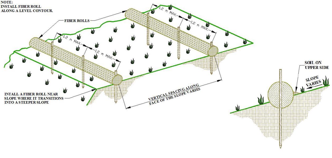
ຄຸນລັກສະນະ ຂອງເຕັກນິກ (ທີ່ກ່ຽວຂ້ອງ ກັບການແຕ້ມແຜນວາດ ທາງດ້ານເຕັກນີກ):
1.Prepare the area to be restored
2.Determine the spacing of the rolls as a function of soil type and slope
3.Installation of erosion rolls (6 m long) and blankets (2.5m x 50 m) must overlap
4.Use wooden stakes to secure the rolls and blankets – rolls (50cm) – 1.2 meter apart, blankets (30cm) – 1meter appart
ຜູ້ຂຽນ:
Erosion Control Technology Council
ວັນທີ:
09/11/2021
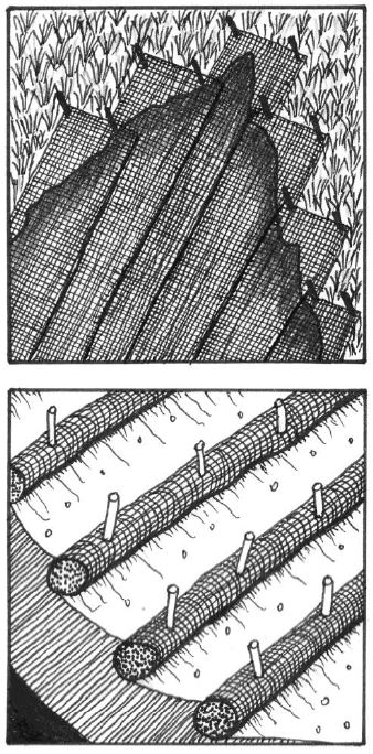
ຄຸນລັກສະນະ ຂອງເຕັກນິກ (ທີ່ກ່ຽວຂ້ອງ ກັບການແຕ້ມແຜນວາດ ທາງດ້ານເຕັກນີກ):
1. The first step in the installation of the erosion blankets on slopes is site preparation. Be sure the site is properly prepared before installing any blankets. The site should be fine graded to a smooth profile and relatively free from all weeds, clods, stones, roots, sticks, rivulets, gullies, crusting and caking. Fill any voids and make sure that the slope is compacted properly.
2. At the top of the slope dig an anchor trench 20 cm deep by 20 cm wide. The blankets will be anchored in this trench with staples.
3. Starting at the crest of the slope, roll the blankets down the slope in a controlled manner.
4. Seed the area to be vegetated (hydroseeding).
ຜູ້ຂຽນ:
Erosion Control Technology Council
ວັນທີ:
09/11/2021
4.2 ຂໍ້ມູນທົ່ວໄປກ່ຽວກັບການຄິດໄລ່ປັດໃຈຂາເຂົ້າໃນການຜະລິດ ແລະ ມູນຄ່າອື່ນໆ
ລະບຸ ວິທີການ ຄຳໃຊ້ຈ່າຍ ແລະ ປັດໄຈນໍາເຂົ້າ ທີ່ໄດ້ຄິດໄລ່:
- ຕໍ່ຫົວໜ່ວຍ ທີ່ໄດ້ຈັດຕັ້ງປະຕິບັດ ເຕັກໂນໂລຢີ
ໃຫ້ລະບຸຫົວໜ່ວຍ:
ha
ກໍານົດຂະຫນາດຂອງຫົວນ໋ວຍ (ຖ້າກ່ຽວຂ້ອງ):
1
ສະກຸນເງິນອື່ນໆ / ປະເທດອື່ນໆ (ລະບຸ):
Rand
ຖ້າກ່ຽວຂ້ອງ, ໃຫ້ລະບຸອັດຕາແລກປ່ຽນຈາກ USD ເປັນສະກຸນເງິນທ້ອງຖິ່ນ (ເຊັ່ນ: 1 USD = 79.9 Brazilian Real): 1 USD =:
15.0
ລະບຸ ຄ່າຈ້າງ ຄ່າແຮງງານສະເລ່ຍ ຕໍ່ ວັນ:
R180
4.3 ການສ້າງຕັ້ງກິດຈະກໍາ
| ກິດຈະກໍາ | Timing (season) | |
|---|---|---|
| 1. | Prepare area to be restored | After fires before onset of rainfall period |
| 2. | Installation of erosion rolls (6m Long) and erosion blankets (2.5 m by 50 m) - must overlap | After fires before onset of rainfall period |
| 3. | Hydroseeding | After installation of erosion rolls and blankets |
4.4 ຕົ້ນທຶນ ແລະ ປັດໄຈຂາເຂົ້າທີ່ຈໍາເປັນໃນຈັດຕັ້ງປະຕິບັດ
| ລະບຸ ປັດໃຈ ນໍາເຂົ້າ ໃນການຜະລີດ | ຫົວໜ່ວຍ | ປະລິມານ | ຕົ້ນທຶນ ຕໍ່ຫົວໜ່ວຍ | ຕົ້ນທຶນທັງໝົດ ຂອງປັດໃຈຂາເຂົ້າ ໃນການຜະລິດ | % ຂອງຕົ້ນທຶນທັງໝົດ ທີ່ຜູ້ນໍາໃຊ້ທີ່ດິນ ໃຊ້ຈ່າຍເອງ | |
|---|---|---|---|---|---|---|
| ແຮງງານ | Unskilled labour (including transport) | per day | 84.0 | 260.0 | 21840.0 | |
| ອຸປະກອນ | Spades, hammer, scissors, rakes, hand saw | per day | 5.0 | 20.0 | 100.0 | |
| ວັດສະດຸໃນການປູກ | Grass seed mix | kg | 50.0 | 100.0 | 5000.0 | |
| ວັດສະດຸກໍ່ສ້າງ | SRFB 10m interval including stakes | per meter | 1000.0 | 50.0 | 50000.0 | |
| ວັດສະດຸກໍ່ສ້າງ | Erosion blankets | per square meter | 10000.0 | 13.0 | 130000.0 | |
| ວັດສະດຸກໍ່ສ້າງ | 1.0 | |||||
| ອື່ນໆ | Hydro seeding (including fiber, binding medium, seed and organic fertilizer) | per ha | 1.0 | 12000.0 | 12000.0 | |
| ຕົ້ນທຶນທັງໝົດ ໃນການຈັດຕັ້ງປະຕິບັດ ເຕັກໂນໂລຢີ | 218940.0 | |||||
| ຄ່າໃຊ້ຈ່າຍທັງໝົດ ສຳລັບການສ້າງຕັ້ງເຕັກໂນໂລຢີ ເປັນສະກຸນເງີນໂດລາ | 14596.0 | |||||
ຖ້າຫາກຜູ້ນຳໃຊ້ທີ່ດິນ ນຳໃຊ້ມູນຄ່າຕ່ຳກວ່າ 100% ໃຫ້ລະບຸ ແມ່ນໃຜເປັນຜູ້ຊ່ວຍ ໃນລາຍຈ່າຍທີ່ເຫຼືອ:
Government
4.5 ບໍາລຸງຮັກສາ / ແຜນຈັດຕັ້ງປະຕິບັດ ກິດຈະກໍາ
| ກິດຈະກໍາ | ໄລຍະເວລາ / ຄວາມຖີ່ | |
|---|---|---|
| 1. | After floods the site must be inspected and restored if necessary | After floods |
| 2. | Remove invasive alien vegetation seedlings | After germination (during first 6 months) |
4.6 ຄ່າໃຊ້ຈ່າຍ ແລະ ປັດໄຈນໍາເຂົ້າທີ່ຈໍາເປັນສໍາລັບການບໍາລຸງຮັກສາກິດຈະກໍາ / ແຜນປະຕິບັດ (ຕໍ່ປີ)
| ລະບຸ ປັດໃຈ ນໍາເຂົ້າ ໃນການຜະລີດ | ຫົວໜ່ວຍ | ປະລິມານ | ຕົ້ນທຶນ ຕໍ່ຫົວໜ່ວຍ | ຕົ້ນທຶນທັງໝົດ ຂອງປັດໃຈຂາເຂົ້າ ໃນການຜະລິດ | % ຂອງຕົ້ນທຶນທັງໝົດ ທີ່ຜູ້ນໍາໃຊ້ທີ່ດິນ ໃຊ້ຈ່າຍເອງ | |
|---|---|---|---|---|---|---|
| ແຮງງານ | Restoration of site after flooding events | per day | 24.0 | 260.0 | 6240.0 | |
| ອຸປະກອນ | Tools to do restoration (same as installation) | per day | 3.0 | 30.0 | 90.0 | |
| ວັດສະດຸໃນການປູກ | Removal of invasive alien vegetation | per day | 24.0 | 60.0 | 1440.0 | |
| ວັດສະດຸກໍ່ສ້າງ | SRFR | per meter | 50.0 | 50.0 | 2500.0 | |
| ວັດສະດຸກໍ່ສ້າງ | Erosion blankets (only pegs) | per square meter | 300.0 | 3.0 | 900.0 | |
| ຕົ້ນທຶນທັງໝົດ ທີ່ໃຊ້ໃນການບໍາລຸງຮັກສາ ເຕັກໂນໂລຢີ | 11170.0 | |||||
| ຄ່າໃຊ້ຈ່າຍທັງໝົດ ສຳລັບການບົວລະບັດຮກສາເຕັກໂນໂລຢີ ເປັນສະກຸນເງີນໂດລາ | 744.67 | |||||
4.7 ປັດໄຈ ທີ່ສໍາຄັນ ທີ່ສົ່ງຜົນກະທົບ ຕໍ່ຄ່າໃຊ້ຈ່າຍ
ໃຫ້ອະທິບາຍ ປັດໃຈ ທີ່ສົ່ງຜົນກະທົບ ຕໍ່ຕົ້ນທຶນ ໃນການຈັດຕັ້ງປະຕິບັດ:
Labour availability, availability of material, transport cost
5. ສະພາບແວດລ້ອມທໍາມະຊາດ ແລະ ມະນຸດ
5.1 ອາກາດ
ປະລິມານນໍ້າຝົນປະຈໍາປີ
- < 250 ມີລິແມັດ
- 251-500 ມີລິແມັດ
- 501-750 ມີລິແມັດ
- 751-1,000 ມີລິແມັດ
- 1,001-1,500 ມີລິແມັດ
- 1,501-2,000 ມີລິແມັດ
- 2,001-3,000 ມີລິແມັດ
- 3,001-4,000 ມີລິແມັດ
- > 4,000 ມີລິແມັດ
ເຂດສະພາບອາກາດກະສິກໍາ
- ເຄິ່ງແຫ້ງແລ້ງ
5.2 ພູມິປະເທດ
ຄ່າສະເລ່ຍ ຄວາມຄ້ອຍຊັນ:
- ພື້ນທີ່ຮາບພຽງ (0-2%)
- ອ່ອນ (3-5 %)
- ປານກາງ (6-10 %)
- ມ້ວນ (11-15 %)
- ເນີນ(16-30%)
- ໍຊັນ (31-60%)
- ຊັນຫຼາຍ (>60%)
ຮູບແບບຂອງດິນ:
- ພູພຽງ / ທົ່ງພຽງ
- ສັນພູ
- ເປີ້ນພູ
- ເນີນພູ
- ຕີນພູ
- ຮ່ອມພູ
ເຂດລະດັບສູງ:
- 0-100 ແມັດ a.s.l.
- 101-500 ແມັດ a.s.l.
- 501-1,000 ແມັດ a.s.l.
- 1,001-1,500 ແມັດ a.s.l.
- 1,501-2,000 ແມັດ a.s.l.
- 2,001-2,500 ແມັດ a.s.l.
- 2,501-3,000 ແມັດ a.s.l.
- 3,001-4,000 ແມັດ a.s.l.
- > 4,000 ແມັດ a.s.l.
ໃຫ້ລະບຸ ເຕັກໂນໂລຢີ ທີ່ໄດ້ຖືກນຳໃຊ້:
- ບໍ່ກ່ຽວຂ້ອງ
5.3 ດິນ
ຄວາມເລິກ ຂອງດິນສະເລ່ຍ:
- ຕື້ນຫຼາຍ (0-20 ຊັງຕີແມັດ)
- ຕື້ນ (21-50 ຊຕມ)
- ເລີກປານກາງ (51-80 ຊຕມ)
- ເລິກ (81-120 ຊມ)
- ເລິກຫຼາຍ (> 120 cm)
ເນື້ອດິນ (ໜ້າດິນ):
- ຫຍາບ / ເບົາ (ດິນຊາຍ)
ເນື້ອດິນ (ເລິກຈາກໜ້າດິນ ລົງໄປຫຼາຍກວ່າ 20 ຊັງຕິແມັດ):
- ປານກາງ (ດິນໜຽວ, ດິນໂຄນ)
5.4 ມີນໍ້າ ແລະ ຄຸນນະພາບ
ລະດັບ ນໍ້າໃຕ້ດິນ:
< 5 ແມັດ
ການມີນໍ້າ ເທິງໜ້າດິນ:
ປານກາງ
ຄຸນນະພາບນໍ້າ (ບໍ່ມີການບໍາບັດ):
ບໍ່ມີນໍ້າດື່ມ (ຮຽກຮ້ອງໃຫ້ມີການບຳບັດນ້ຳ)
ຄຸນນະພາບນ້ຳ ໝາຍເຖີງ:
ນ້ຳໜ້າດິນ
ມີບັນຫາ ກ່ຽວກັບນໍ້າເຄັມບໍ່?
ບໍ່ແມ່ນ
ເກີດມີນໍ້າຖ້ວມ ໃນພື້ນທີ່ບໍ່?
ບໍ່ແມ່ນ
5.5 ຊີວະນາໆພັນ
ຄວາມຫຼາກຫຼາຍ ທາງສາຍພັນ:
- ສູງ
ຄວາມຫຼາກຫຼາຍ ທາງດ້ານ ທີ່ຢູ່ອາໃສ ຂອງສິ່ງທີ່ມີຊີວິດ:
- ຕໍ່າ
5.6 ຄຸນລັກສະນະ ຂອງຜູ້ນໍາໃຊ້ທີ່ດິນ ທີ່ໄດ້ນໍາໃຊ້ເຕັກໂນໂລຢີ
ຢູ່ປະຈຳ ຫຼື ເຄື່ອນຍ້າຍຕະຫຼອດ:
- ບໍ່ເຄື່ອນໄຫວ
ລະບົບ ການຕະຫຼາດ ແລະ ຜົນຜະລິດ:
- ການຄ້າ / ຕະຫຼາດ
ລາຍຮັບ ທີ່ບໍ່ໄດ້ມາຈາກ ການຜະລິດ ກະສິກໍາ:
- > 50 % ຂອງລາຍຮັບທັງໝົດ
ລະດັບຄວາມຮັ່ງມີ:
- ຮັ່ງມີ
ອາຍຸ ຂອງຜູ້ນໍາໃຊ້ທີ່ດິນ:
- ໄວກາງຄົນ
5.7 ເນື້ອທີ່ສະເລ່ຍຂອງດິນ ທີ່ຜູ້ນຳໃຊ້ທີ່ດິນ ໃຊ້ເຮັດເຕັກໂນໂລຢີ
- <0.5 ເຮັກຕາ
- 0.5-1 ເຮັກຕາ
- 1-2 ເຮັກຕາ
- 2-5 ເຮັກຕາ
- 5-15 ເຮັກຕາ
- 15-50 ເຮັກຕາ
- 50-100 ເຮັກຕາ
- 100-500 ເຮັກຕາ
- 500-1,000 ເຮັກຕາ
- 1,000-10,000 ເຮັກຕາ
- > 10,000 ເຮັກຕາ
5.8 ເຈົ້າຂອງທີ່ດິນ, ສິດໃຊ້ທີ່ດິນ, ແລະ ສິດທິການນໍາໃຊ້ນໍ້າ
ເຈົ້າຂອງດິນ:
- ລັດ
- municipality owned
- municipality
ສິດນຳໃຊ້ທີ່ດິນ ແມ່ນ ອີງໃສ່ລະບົບກົດໝາຍແບບດັ້ງເດີມບໍ?
ບໍ່ແມ່ນ
5.9 ການເຂົ້າເຖິງການບໍລິການ ແລະ ພື້ນຖານໂຄງລ່າງ
ສຸຂະພາບ:
- ທຸກຍາກ
- ປານກາງ
- ດີ
ການສຶກສາ:
- ທຸກຍາກ
- ປານກາງ
- ດີ
ການຊ່ວຍເຫຼືອ ດ້ານວິຊາການ:
- ທຸກຍາກ
- ປານກາງ
- ດີ
ການຈ້າງງານ (ຕົວຢ່າງ, ການເຮັດກິດຈະກໍາອື່ນ ທີ່ບໍ່ແມ່ນ ການຜະລິດກະສິກໍາ):
- ທຸກຍາກ
- ປານກາງ
- ດີ
ຕະຫຼາດ:
- ທຸກຍາກ
- ປານກາງ
- ດີ
ພະລັງງານ:
- ທຸກຍາກ
- ປານກາງ
- ດີ
ຖະໜົນຫົນທາງ ແລະ ການຂົນສົ່ງ:
- ທຸກຍາກ
- ປານກາງ
- ດີ
ການດື່ມນໍ້າ ແລະ ສຸຂາພິບານ:
- ທຸກຍາກ
- ປານກາງ
- ດີ
ການບໍລິການ ທາງດ້ານການເງິນ:
- ທຸກຍາກ
- ປານກາງ
- ດີ
6. ຜົນກະທົບ ແລະ ລາຍງານສະຫຼຸບ
6.1 ການສະແດງຜົນກະທົບ ພາຍໃນພື້ນທີ່ ທີ່ໄດ້ຈັດຕັ້ງປະຕິບັດ ເຕັກໂນໂລຢີ
ຜົນກະທົບທາງເສດຖະກິດສັງຄົມ
ລາຍໄດ້ ແລະ ຄ່າໃຊ້ຈ່າຍ
ຄວາມຫຼາກຫຼາຍ ຂອງແຫຼ່ງລາຍຮັບ
ຄວາມຄິດເຫັນ / ລະບຸແຈ້ງ:
Restoration resulted in job creation for local communities
ຜົນກະທົບດ້ານວັດທະນາທໍາສັງຄົມ
ໂອກາດ ໃນການພັກຜ່ອນຢ່ອນໃຈ
ຄວາມຄິດເຫັນ / ລະບຸແຈ້ງ:
Improved ecotourism - land restored to natural state - hiking and cycling
Value of land for development
ຄວາມຄິດເຫັນ / ລະບຸແຈ້ງ:
Land without degradation more valuable for development
ຜົນກະທົບຕໍ່ລະບົບນິເວດ
ວົງຈອນນໍ້າ / ນໍ້າ
ການໄຫຼ ຂອງນໍ້າໜ້າດິນ
ຄວາມຄິດເຫັນ / ລະບຸແຈ້ງ:
The introduction of structures and increased vegetation cover resulted in reduced runoff
ການລະບາຍນໍ້າ
ຄວາມຄິດເຫັນ / ລະບຸແຈ້ງ:
The introduced technologies also improved excess water drainage and less flooding
ດິນ
ການປົກຄຸມຂອງດິນ
ຄວາມຄິດເຫັນ / ລະບຸແຈ້ງ:
Vegetation cover improved with the introduction of hydroseeding and retention of topsoil containing indigenous seed
ການສູນເສຍດິນ
ຄວາມຄິດເຫັນ / ລະບຸແຈ້ງ:
Soil loss was reduced due to the introduction of the SRFR and improved vegetation cover
ຊີວະນານາພັນ: ສັດ, ພືດ
ການປົກຫຸ້ມຂອງພືດ
ຄວາມຄິດເຫັນ / ລະບຸແຈ້ງ:
Vegetation cover improved due to the soil stabilisation and introduction of hydroseeding (annual grass protected soil until natural vegetation established)
ມວນຊີວະພາບ / ຢູ່ເທິງຊັ້ນດິນ C
ຄວາມຄິດເຫັນ / ລະບຸແຈ້ງ:
Improved biomass due to the improved vegetation cover and reduction of soil loss (topsoil with high C content)
ສາຍພັນຕ່າງຖີ່ນ
ຄວາມຄິດເຫັນ / ລະບຸແຈ້ງ:
Maintenance of the applied technology included the removal of alien species
ຄວາມຫຼາກຫຼາຍ ທາງດ້ານທີ່ຢູ່ອາໃສ ຂອງສິ່ງທີ່ມີຊີວິດ
ຄວາມຄິດເຫັນ / ລະບຸແຈ້ງ:
The technology resulted in the reestablishment of the natural vegetation and improved biodiversity
ການຫຼຸດຜ່ອນ ຄວາມສ່ຽງ ຈາກໄພພິບັດ ແລະ ອາກາດປ່ຽນແປງ
ຜົນກະທົບ ຂອງນໍ້າຖ້ວມ
ຄວາມຄິດເຫັນ / ລະບຸແຈ້ງ:
One of the main reasons for the introduction of this innovative technology is the reduction in flood impacts due to the inclusion of structures as well as improved vegetation cover
ການເຊາະເຈື່ອນຂອງດິນ / ຊາກສະລະຫະພັງ
ຄວາມຄິດເຫັນ / ລະບຸແຈ້ງ:
The added benefit of the technology is the reduction in the risk of landslides due to the inclusion of soil stabilising structures and improved vegetation cover
6.2 ຜົນກະທົບທາງອ້ອມ ຈາກການນໍາໃຊ້ເຕັກໂນໂລຢີ
ນໍ້າຖ້ວມຢູ່ເຂດລຸ່ມນໍ້າ
ຄວາມຄິດເຫັນ / ລະບຸແຈ້ງ:
The introduction of the technology resulted in improved drainage and therefore less downstream flooding
ການທັບຖົມ ຂອງດິນຕະກອນ ຢູ່ເຂດລຸ່ມນໍ້າ
ຄວາມຄິດເຫັນ / ລະບຸແຈ້ງ:
The introduction of sediment trapping structures as well as improved vegetation cover resulted in less downstream siltation
ຄວາມເສຍຫາຍ ກ່ຽວກັບພື້ນຖານໂຄງລ່າງ ສາທາລະນະ / ເອກກະຊົນ
ຄວາມຄິດເຫັນ / ລະບຸແຈ້ງ:
The risk of damage to infrastructure was reduced due to the decrease in risk of flooding and landslides
6.3 ການປ້ອງກັນ ແລະ ຄວາມບອບບາງ ຂອງເຕັກໂນໂລຢິ ໃນການປ່ຽນແປງສະພາບດິນຟ້າອາກາດ ແລະ ກ່ຽວຂ້ອງກັບອາກາດທີ່ມີການປ່ຽນແປງທີ່ຮຸນແຮງ / ໄພພິບັດທາງທໍາມະຊາດ (ຮັບຮູ້ໄດ້ໂດຍຜູ້ນໍາໃຊ້ທີ່ດິນ)
ອາກາດ ທີ່ກ່ຽວພັນກັບຄວາມຮຸນແຮງ (ໄພພິບັດທາງທໍາມະຊາດ)
ໄພພິບັດທາງອຸຕຸນິຍົມ
| ການນໍາໃຊ້ ເຕັກໂນໂລຢີ ສາມາດ ຮັບມື ໄດ້ຄືແນວໃດ? | |
|---|---|
| ພະຍຸຝົນ | ປານກາງ |
ໄພພິບັດທາງພູມອາກາດ
| ການນໍາໃຊ້ ເຕັກໂນໂລຢີ ສາມາດ ຮັບມື ໄດ້ຄືແນວໃດ? | |
|---|---|
| ໄຟໄໝ້ປ່າ | ບໍ່ດີຈັກຢ່າງ |
6.4 ການວິເຄາະຕົ້ນທຶນ ແລະ ຜົນປະໂຫຍດ
ຈະເຮັດປະໂຫຍດເພື່ອປຽບທຽບກັບຄ່າໃຊ້ຈ່າຍກັບສິ່ງກໍ່ສ້າງ (ຈາກທັດສະນະຂອງຜູ້ນຳໃຊ້ທີ່ດິນ) ໄດ້ແນວໃດ?
ຜົນຕອບແທນ ໃນໄລຍະສັ້ນ:
ຜົນກະທົບທາງບວກ
ຜົນຕອບແທນ ໃນໄລຍະຍາວ:
ຜົນກະທົບທາງບວກ
ຈະໄດ້ຮັບຜົນປະໂຫຍດເມື່ອປຽບທຽບກັບ / ຄ່າໃຊ້ຈ່າຍໃນການບຳລຸງຮັກສາທີເ່ກີດຂື້ນອິກ (ຈາກທັດສະນະຄະຕິຂອງຜູ້ນຳໃຊ້ທີ່ດິນ) ໄດ້ແນວໃດ?
ຜົນຕອບແທນ ໃນໄລຍະສັ້ນ:
ຜົນກະທົບທາງບວກ
ຜົນຕອບແທນ ໃນໄລຍະຍາວ:
ຜົນກະທົບທາງບວກ
6.5 ການປັບຕົວຮັບເອົາເຕັກໂນໂລຢີ
- ກໍລະນີດຽວ / ການທົດລອງ
6.6 ການປັບຕົວ
ໄດ້ມີການດັດປັບ ເຕັກໂນໂລຢີ ເພື່ອໃຫ້ແທດເໝາະກັບເງື່ອນໄຂ ການປ່ຽນແປງບໍ?
ບໍ່ແມ່ນ
6.7 ຈຸດແຂງ / ຂໍ້ດີ / ໂອກາດ ໃນການນໍາໃຊ້ ເຕັກໂນໂລຢີ
| ຈຸດແຂງ / ຂໍ້ດີ / ໂອກາດໃນການນໍາໃຊ້ທີ່ດິນ |
|---|
| Very important technology to stabilise degraded landscapes |
| Technology helps to improve the habitat - biodiversity in the protected area |
| Technology helps to prevent landslides and down-stream siltation |
| ຈຸດແຂງ / ຈຸດດີ / ໂອກາດ ຈາກທັດສະນະຂອງຜູ້ປ້ອນຂໍ້ມູນ ຫຼື ບຸກຄົນສຳຄັນ |
|---|
| Although fairly expensive to implement the technology helped to restore high value land in the Knysna area |
6.8 ຈຸດອ່ອນ / ຂໍ້ເສຍ / ຄວາມສ່ຽງ ໃນການນໍາໃຊ້ ເຕັກໂນໂລຢີ ແລະ ວິທີການແກ້ໄຂບັນຫາ
| ຈຸດອ່ອນ / ຂໍ້ເສຍ / ຄວາມສ່ຽງໃນມຸມມອງຂອງຜູ້ນໍາໃຊ້ທີ່ດິນ | ມີວິທີການແກ້ໄຂຄືແນວໃດ? |
|---|---|
| Sensitive to fire | Construct fire breaks around areas of intervention |
| Sensitive to flooding | Better timing of intervention (avoid high rainfall periods) |
7. ເອກະສານອ້າງອີງ ແລະ ການເຊື່ອມຕໍ່
7.1 ວິທີການ / ແຫຼ່ງຂໍ້ມູນ
- ການໄປຢ້ຽມຢາມພາກສະໜາມ, ການສໍາຫຼວດພາກສະໜາມ
- ສໍາພາດ ຊ່ຽວຊານ ການຄຸ້ມຄອງ ດິນແບບຍືນຍົງ
1
- ການລວບລວມ ບົດລາຍງານ ແລະ ເອກະສານ ອື່ນໆ ທີ່ມີຢູ່ແລ້ວ
1
ເມື່ອໃດທີ່ໄດ້ສັງລວມຂໍ້ມູນ (ຢູ່ພາກສະໜາມ)?
27/09/2021
7.2 ເອກກະສານອ້າງອີງທີ່ເປັນບົດລາຍງານ
ຫົວຂໍ້, ຜູ້ຂຽນ, ປີ, ISBN:
Title, author, year, ISBN Caring for Natural Rangelands, Ken Coetzee, 978-1-86914-071-7
ມີຢູ່ໃສ?ມູນຄ່າເທົ່າໃດ?
https://www.loot.co.za/product/ken-coetzee-caring-for-natural-rangelands/stkr-450-g690
7.3 ເຊື່ອມຕໍ່ກັບຂໍ້ມູນທີ່ກ່ຽວຂ້ອງໂດຍກົງ
ຫົວຂໍ້ / ພັນລະນາ:
KNYSNA FIRES: HOW SOON WE FORGET
URL:
https://www.scli.org.za/knysna-fires-soon-forget
ຫົວຂໍ້ / ພັນລະນາ:
Sediment retention fiber rolls – general usage and installation guidelines April 2011
URL:
https://www.ectc.org
ຂໍ້ມູນການເຊື່ອມຕໍ່ ແລະ ເນື້ອໃນ
ຂະຫຍາຍທັງໝົດ ຍຸບທັງໝົດການເຊື່ອມຕໍ່
Working for Water [ອາຟິກກາໃຕ້]
Government funded restoration/rehabilitation initiative as part of Working for Water project. Aim was to eradicate alien invasive.
- ຜູ້ສັງລວມຂໍ້ມູນ: Klaus Kellner
ເນື້ອໃນ
ບໍ່ມີເນື້ອໃນ