Social Tenure Domain Model (STDM) [Кени]
- Шинийг нээх:
- Шинэчлэх:
- Мэдээлэл цуглуулсан: Ken Otieno
- Редактор: –
- Хянагчид: Donia Mühlematter, Hanspeter Liniger, Barbara *, Alexandra Gavilano
STDM
technologies_3318 - Кени
- Бүрэн хураангуйг PDF-ээр
- Бүрэн хураангуйг PDF-ээр хэвлэх
- Хөтөч дэх бүрэн хураангуй
- Бүрэн хураангуй (форматгүй)
- Social Tenure Domain Model (STDM): 05 7-р сар 2018 (inactive)
- Social Tenure Domain Model (STDM): 07 5-р сар 2019 (public)
- Social Tenure Domain Model (STDM): 28 6-р сар 2018 (inactive)
- Social Tenure Domain Model (STDM): 04 6-р сар 2018 (inactive)
- Social Tenure Domain Model (STDM): 19 5-р сар 2018 (inactive)
- Social Tenure Domain Model (STDM): 05 3-р сар 2018 (inactive)
Бүлгүүдийг үзэх
Бүгдийг харуулах Бүгдийг хаах1. Ерөнхий мэдээлэл
1.2 Технологийг үнэлэх, баримтжуулах ажилд хамаарах мэдээлэл өгсөн хүмүүс, байгууллагуудын холбоо барих мэдээлэл
Технологи баримтжуулах/үнэлэх ажилд дэмжлэг үзүүлсэн төслийн нэр (шаардлагатай бол)
Book project: Guidelines to Rangeland Management in Sub-Saharan Africa (Rangeland Management)1.3 WOCAT-аар баримтжуулсан өгөгдлийг ашиглахтай холбоотой нөхцөл
Эмхэтгэгч болон гол мэдээлэгч хүн(хүмүүс) WOCAT аргачлалаар баримтжуулсан мэдээллийг ашиглахтай холбоотой нөхцлийг хүлээн зөвшөөрсөн.
Тийм
1.4 Технологи тогтвортой гэдгийг баталгаажуулах
Энэ технологи азрын доройтлыг бууруулахад нөлөө үзүүлэхгүй тул газрын тогтвортой менежментийн технологи болж чадахгүй юу?
Үгүй
Тайлбар:
The technology has demonstrated SLM.
2. ГТМ Технологийн тодорхойлолт
2.1 Технологийн товч тодорхойлолт
Технологийн тодорхойлолт:
The Social Tenure Domain Model (STDM) is about people and their relationships with land. The tool as applied secures tenure through the recognition of tenure diversity and social contexts. In the management of land and resources use, STDM facilitates proper land use and management to minimize practices that lead to degradation.
2.2 Технологийн дэлгэрэнгүй тайлбар
Тодорхойлолт:
Technology application: The Social Tenure Domain Model is applied in order to relate natural and human environments. It is a social tool that defines the relationship of persons to natural resources such as land, their utilization of it, and sharing - for sustainable development. To realize optimal resource utilization, the tool enables the direct engagement of the resource users in a collective and participatory way. The technology allows communities to be part of a guided data collection and data entry into an STDM platform. The data includes social and economic data based on what is needed. The platform also can enable storage of information and documents such as title deeds. Names, gender, properties where the community members needs to have such information. These details can be updated and can inform planning and resource allocation by government and development partners. Main characteristics of the technology: STDM is a relational database built on an open source GIS platform called Quontum GIS (QGIS), running on Postgres SQL. This tool was built by Global Tools Land Network (GLTN). The tool captures both spatial information related to locations of land parcels, natural resources captured in points and defined in maps. Secondly, the technology captures socio-economic aspects of a resource, and allows definition of the type of relationship that exists between the resource and the person, as well as an indication of the percentage particular tenure regime in the areas including the existing rights and how they play out. The system recognizes the different level of rights thus appreciating that they are multiple and overlaid resulting to multiple uses. Therefore the technology enables the capture of bundles of rights that people have/should enjoy in a resource. The technology allows generation of reports and performs the desired analysis by the proponents and the beneficiaries of the information stored within the databases. It is open source, thus available free -hence its sustainability.The purposes/ functions of the STDM: The functions of the technology as have been piloted by RECONCILE and partners has focused around land tenure. It addresses security of tenure for vulnerable poor communities living within informal settlements, through participatory common resource identification, mapping and documentation, key resources including cattle dips, salt lick areas/fields and water points management has improved. This is due to the recognition of boundaries anticipatorily defined leading to revival of and establishment of community resources management committees especially around water and grazing lands. This in return has improved /increased production of both plants and animals. However, the technology can be customized to serve other purposes of information storage and management. The major activities/ inputs needed to establish/ maintain the technology: Major inputs are needed in empowerment of local communities through building their capacity to apply the technology through their own initiative. Building community-based resource centres and equipping them with computers installed with the software ensures that the technology is centred on the day-to-day activities of the communities and institutions. Benefits/ impacts: The technology has left better organised communities in terms of managing land and other resources. The technology has assisted local governments to manage issues of land ownership, especially within the context of customary land tenure and ownership. The county governments of Kenya, for instance, have spatial data and information that can help in planning and resources allocation. In areas where the technology has been used in the context of RECONCILE's work, better services and resources can be acquired given accurate information of Mapping land tenure, boundaries, water points and the water rights, infrastructure, different grazing lands and plans for the utilization of the grazing land and the rights of different users. It can result in improved and sustainable use of natural resources which in turn have a direct impact on production. Small-scale dairy farmers have been able to manage grazing lands, water and salt licks to improve production of animal products. Information captured and managed by the technology has enabled communities within informal settlements to negotiate with government authorities to enable land allocation and thus security of tenure and improved livelihoods.What do land users like / dislike about the technology?Likes: The technology is flexible, it can be customized to capture information in any form desired. It is based on a GIS platform which is easy to manipulate and is open source.Dislikes: Users sometimes encounter errors that are a result of incorrect information entered, and these errors are written with the programming format: thus it requires good knowledge of the technology to remedy this.
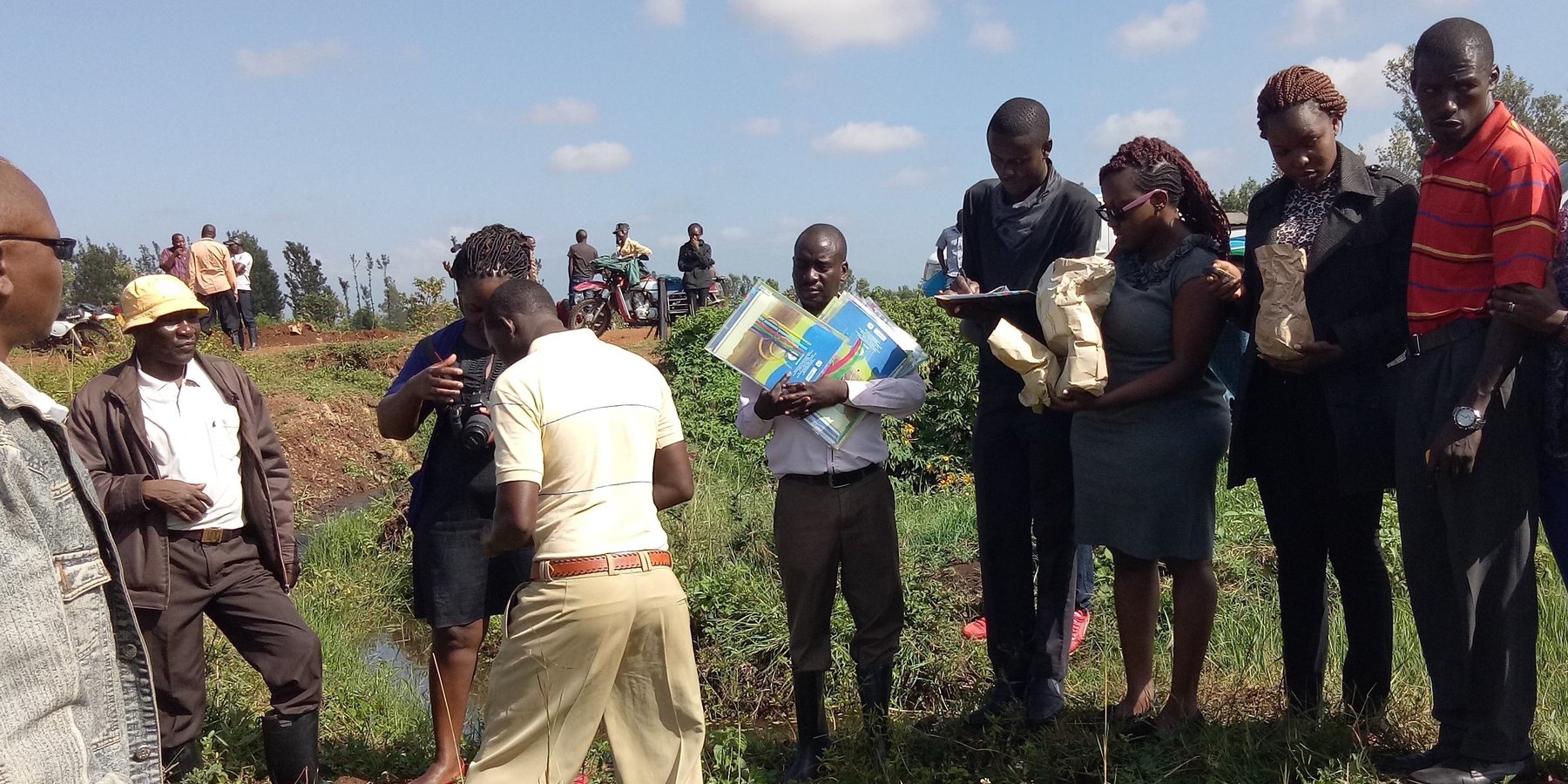
2.3 Технологийн гэрэл зураг
Медиа галерей
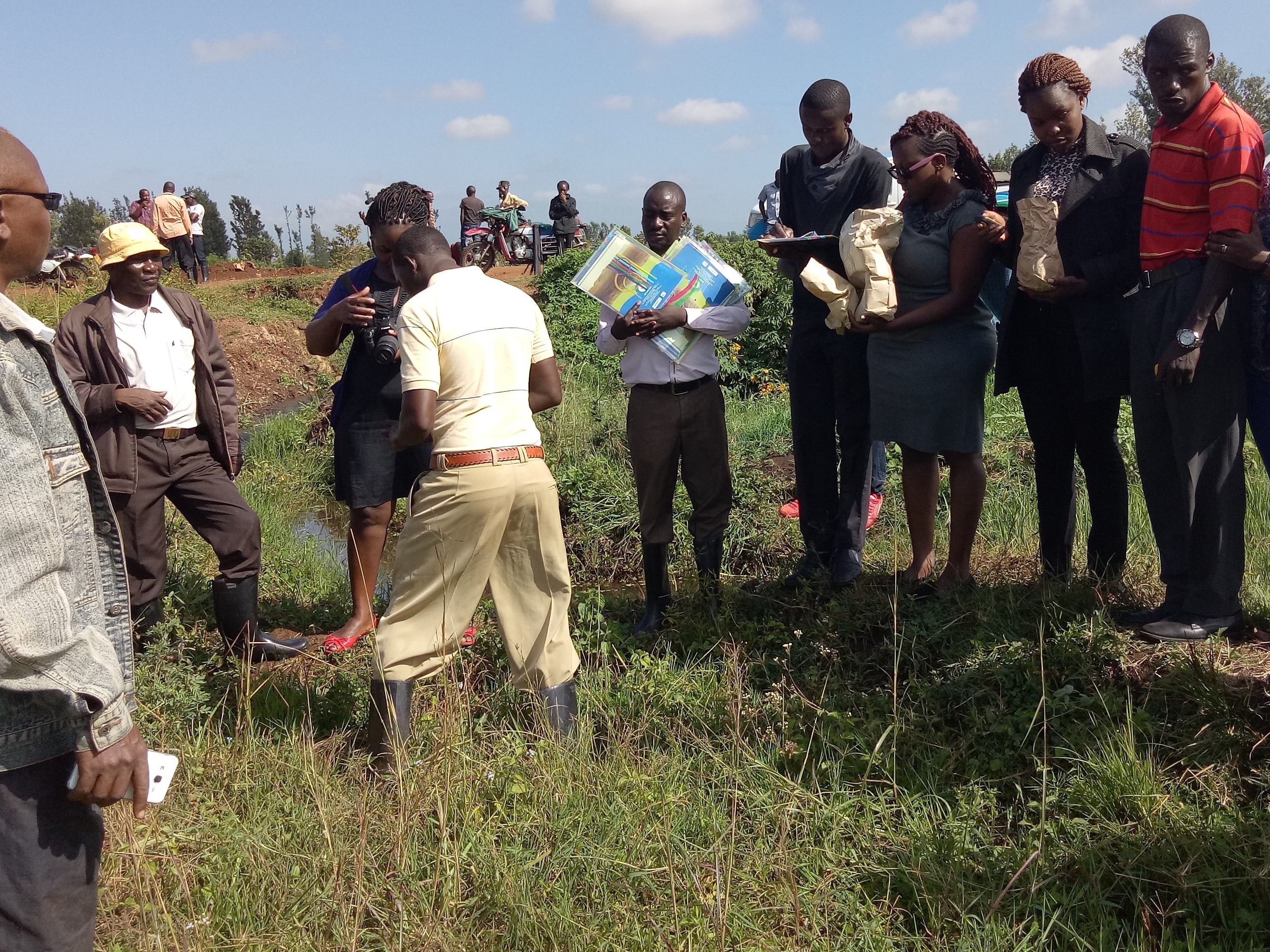
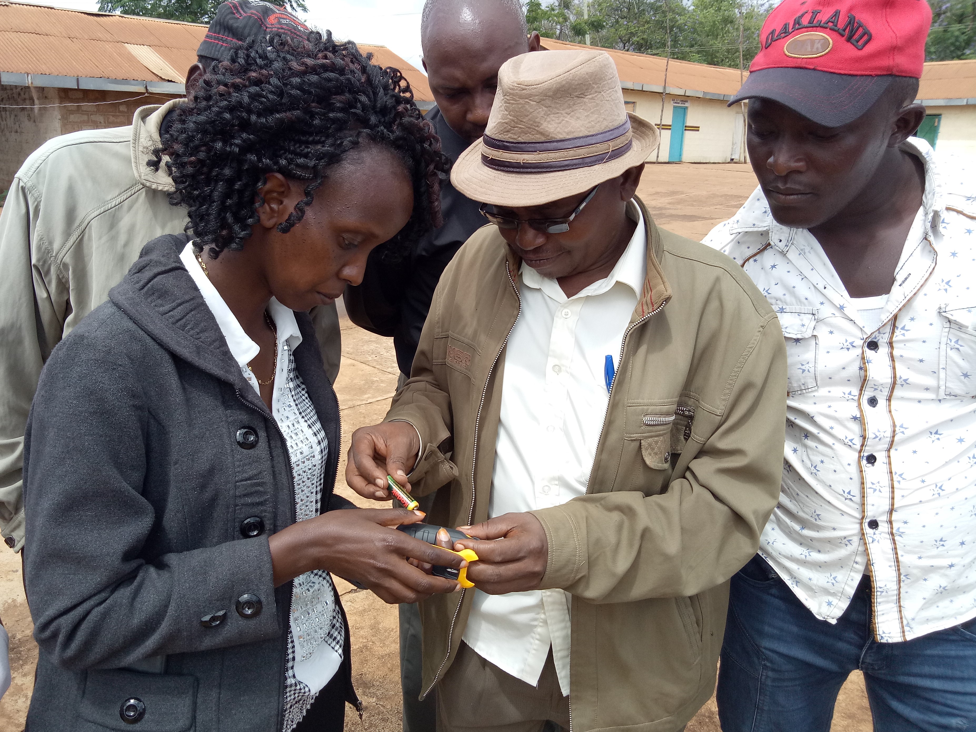
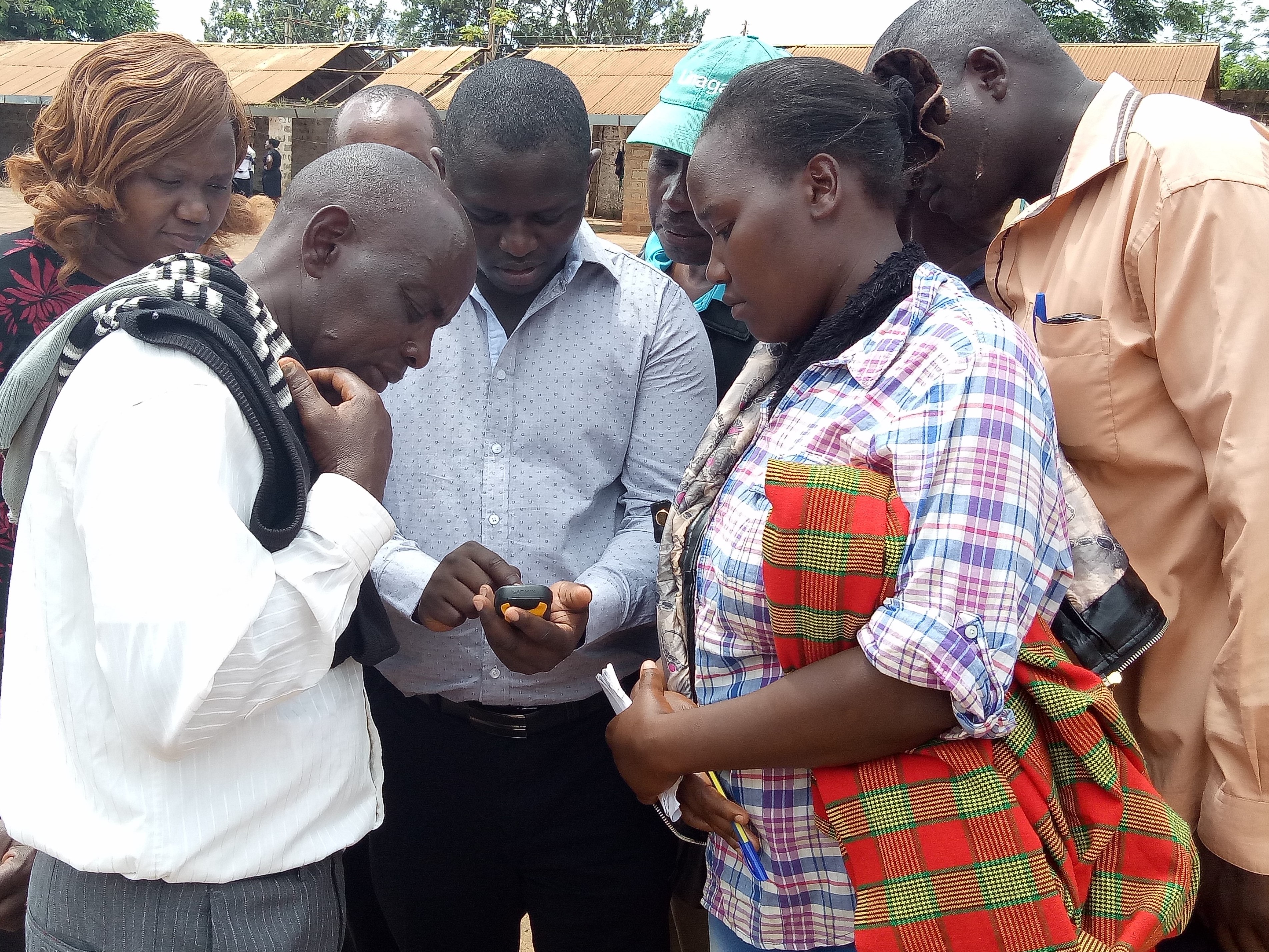
Гэрэл зурагтай холбоотой ерөнхий тэмдэглэл:
This activity was done to complement the social economic data collected and create the ability to understand the social tenure relationship between farmers and the common resources.
2.5 Энэ үнэлгээнд хамрагдсан технологийг хэрэгжүүлсэн улс орон / бүс нутаг / байршил
Улс :
Кени
Улс/аймаг/сум:
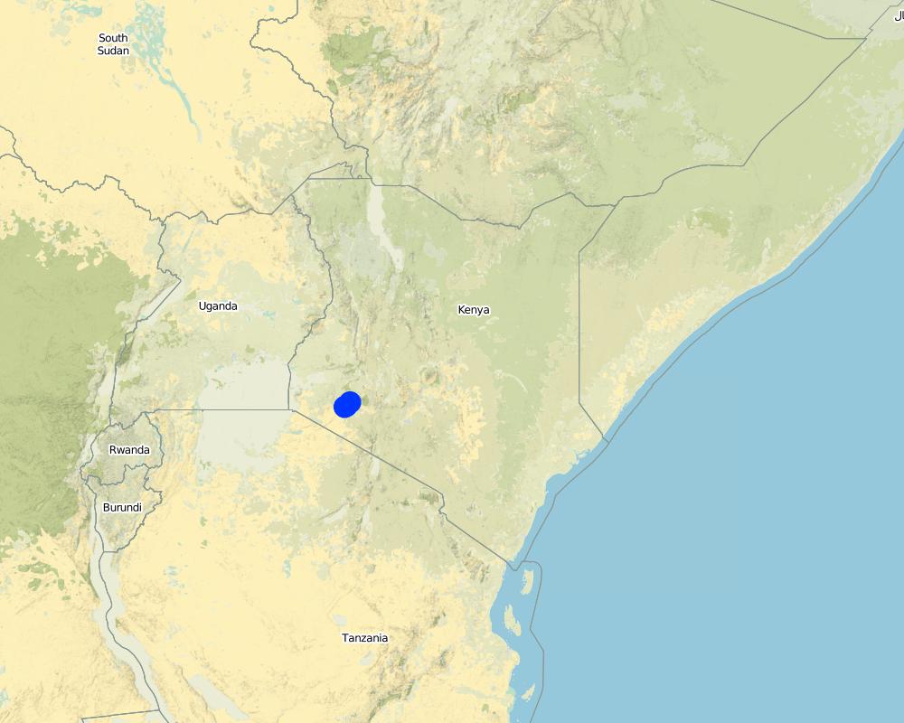
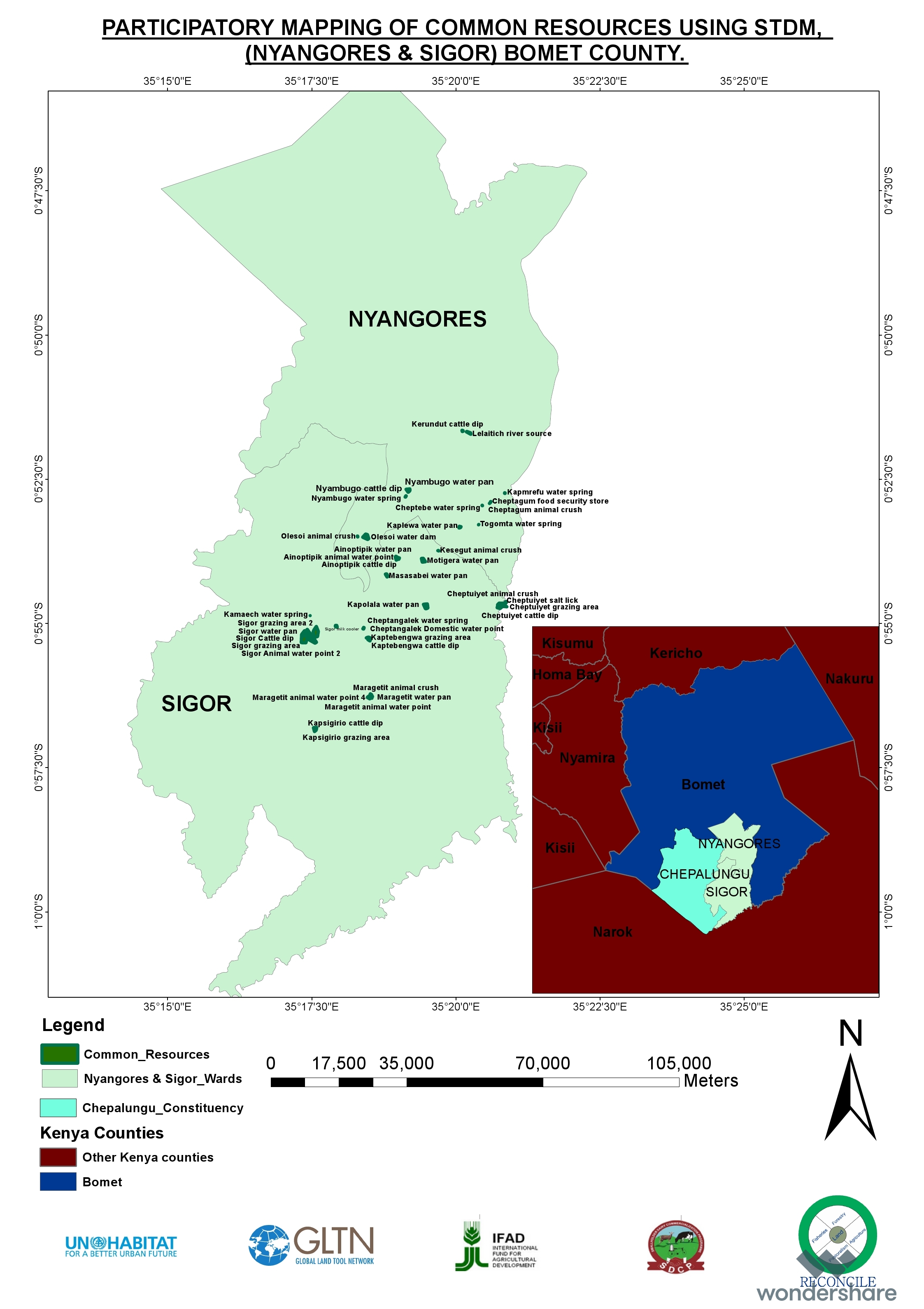
Bomet county
Байршлын дэлгэрэнгүй тодорхойлолт:
Kembu sub-county
Технологи өргөн дэлгэрсэн эсхийг тодорхойл:
- газар дээр жигд тархсан
Хэрэв талбайн хэмжээ тодорхойгүй бол талбайн хэмжээг ойролцоогоор тодорхойлно уу.
- 10-100 км2
Тайлбар:
The technology is applicable in both. It can be customized to fit any use. The best outcome though is total area social enumeration and spatial mapping.
Map
×2.6 Хэрэгжих огноо
Хэрэгжүүлсэн он:
2016
2.7 Технологийн танилцуулга
Технологийг хэрхэн нэвтрүүлснийг тодорхойл:
- Гадны төсөл/хөтөлбөрийн дэмжлэгтэйгээр
3. ГТМ технологийн ангилал
3.1 Технологийн үндсэн зорилго (д)
- Үйлдвэрлэлийг сайжруулах
- Газрын доройтлыг бууруулах, сэргийлэх, нөхөн сэргээх
- Экосистемийг хамгаалах
- Сав газар / доод урсгалыг хамгаалах - бусад технологитой хослуулах
3.2 Технологи хэвтрүүлсэн газрын одоогийн газар ашиглалтын хэлбэр(д)
Нэг газр нутгийн хэмжээнд хэрэгжих холимог газар ашиглалт:
Тийм
Газар ашиглалтын холимог тогтолцоог (тарилан/бэлчээр/ой мод) тодорхойл:
- Агро-бэлчээр (тарилан-мал аж ахуйн хослуулсан тогтолцоог хамруулан ойлгоно)

Тариалангийн газар
Нэг жил дэх ургамал ургах улирлын тоо:
- 2
Тодорхойлно уу:
April to October and November through March

Бэлчээрийн газар
Нүүдлийн бэлчээр ашиглалт:
- Хагас нүүдлийн бэлчээрийн аж ахуй
Эрчимжсэн бэлчээр / тэжээл үйлдвэрлэл:
- Хадлан буюу бэлчээрт ашиглагдахгүй талбай
амьтдын төрөл зүйл:
- үхрийн аж ахуй - махны чиглэлийн үхэр
- үхрийн аж ахуй - цагаан идээ
Бүтээгдэхүүн ба үйлчилгээ:
- сүү
- арьс/шир
- мах
Тайлбар:
Main animal species and products: The cattle kept in Ndaraweta are mainly cross-breeds between local animals and Friesian or Ayrshire cattle. The communities are currently in an advance stage of upgrading, but they still keep some short-horned local zebu cows as well. The cattle are kept for multiple uses including milk, meat, and hides. The communities grow hay for local use and sale within.
The technology did therefore help the communities to appreciate the common resources that support the livestock keeping.
3.3 Технологи хэрэгжүүлснээс газар ашиглалтад өөрчлөлт гарсан уу?
Тайлбар:
Before the mapping exercise, the management of most common resources were not given much attention. After participatory mapping and documenting these resources and the establishment of information on encroachment, degradation and the neglected water points, communities took up the management of the resources more seriously and therefore improved knowledge and clarity around the land tenure rights for the communities and the need for tenure security and protection of rangelands and the resources therein.
3.4 Усан хангамж
Технологи хэрэгжүүлсэн газрын усан хангамж:
- Байгалийн усалгаатай
3.5 Технологи ГТМ-ийн аль бүлэгт хамаарах
- Байгалийн ба хагас-байгалийн ойн менежмент
- Бэлчээрийн мал аж ахуй ба бэлчээрийн газрын менежмент
- Газар тариалан-мал аж ахуйн нэгдсэн менежмент
3.6 Технологийг бүрдүүлэх ГТМ арга хэмжээ

Менежментийн арга хэмжээ
- М1: Газар ашиглалтын хэлбэрийг өөрчлөх
- М2: Ашиглалтын менежмент/эрчимийг өөрчлөх
- M3: Байгаль ба нийгмийн орчинд тохируулан зохион байгуулах
3.7 Технологийн шийдвэрлэсэн газрын доройтлын үндсэн төрлүүд

Усны доройтол
- Hs: Гадаргын усны хэмжээ багасах
- Усны элэгдлээс хамгаалах чадвар муудах

Бусад
Тайлбар:
Land degradation in rangelands is a problem that is being experienced and other challenges especially in the areas where agro-pastoralism is practiced include sustainable land use and management. The mapping process while not having direct response to these issues, it demonstrated that the communities can use sustainable means in land use through land use planning.
3.8 Газрын доройтлоос урьдчилан сэргийлэх, сааруулах ба нөхөн сэргээх
Газрын доройтолтой холбоотойгоор Технологи ямар зорилго тавьсан болохыг тодорхойл:
- Газрын доройтлыг багасгах сааруулах
- газрын доройтолд дасан зохицох
4. Техникийн нөхцөл, хэрэгжилтийн үйл ажиллагаа, материал ба зардал
4.1 Технологийн техникийн зураг
Техник тодорхойлолт (техник зурагтай уялдана):
The overall space or measurements for the project areas were within the range of 25 to 75 square kilometres.
Зохиогч:
RECONCILE
Он, сар, өдөр:
15/06/2016
4.2 Материал болон зардалд хамаарах ерөнхий мэдээлэл
Үнэ өртөг, оруулсан хувь нэмрийг хэрхэн тооцсоныг тодорхойл:
- Технологийн нэгж тус бүр
Хэмжээ ба нэгж талбайг тодорхойл:
Each project area 25 km2 (Project areas of three Sub-Counties 75 km2)
Үнэ өртөгийг тооцоход ашигласан мөнгөн нэгж:
- Ам.доллар
Хэрэв боломжтой бол үндэсний валютын Америк доллартай харьцах харьцааг бичнэ үү (тухайлбал, 1 ам.дол. = 79,9 Бразил реал): 1 ам.дол. =:
101.0
Хөлсний ажилчны нэг өрдийн ажлын хөлсийг тодорхойл:
between Ksh. 2000 to 3000 depending on the kind of labour required and can go down to a compromised rate of ksh. 1000.
4.3 Байгуулах үйл ажиллагаа
| Үйл ажиллагаа | Хугацаа (улирал) | |
|---|---|---|
| 1. | Enumeration of at least 1000 farmers | 9 months |
| 2. | Mapping of communal resources water points, salt lick areas, cattle dips etc | 9 months |
| 3. | Mapping of private resources water points within the private areas | 9 months |
| 4. | Data Management | 3 months |
| 5. | Preparation of data collection including testing of the tools | 1 month |
| 6. | Dialogue sessions with community leaders | 2 months |
| 7. | Negotiations on the methodology for data collection and the kind of information to be collected/asked | 1 month |
| 8. | Technical reviews and reflection with project team and partners | 1 month |
Тайлбар:
The kind of tasks undertaken in this process is more project oriented combined with advocacy and policy processes.
4.4 Байгуулалтад шаардагдах зардал ба материал
| Хөрөнгө оруулалтыг дурьдана уу | Хэмжих нэгж | Тоо хэмжээ | Нэгжийн өртөг | Материал бүрийн нийт өртөг | % газар ашиглачаас гарсан зардал | |
|---|---|---|---|---|---|---|
| Хөдөлмөр эрхлэлт | Enumerators | persons | 90.0 | 50.0 | 4500.0 | |
| Хөдөлмөр эрхлэлт | Consultants | Persons | 6.0 | 1000.0 | 6000.0 | |
| Хөдөлмөр эрхлэлт | Technical Staff contribution and time | persons | 5.0 | 750.0 | 3750.0 | |
| Хөдөлмөр эрхлэлт | Data processing and management | persons | 24.0 | 60.0 | 1440.0 | |
| Тоног төхөөрөмж | Data entry and analysis | persons | 20.0 | 40.0 | 800.0 | |
| Тоног төхөөрөмж | GPS hiring | 120.0 | 55.0 | 6600.0 | ||
| Тоног төхөөрөмж | GPS purchase | 5.0 | 320.0 | 1600.0 | ||
| Тоног төхөөрөмж | Computers | 4.0 | 750.0 | 3000.0 | ||
| Тоног төхөөрөмж | Conferences | 9.0 | 1500.0 | 13500.0 | ||
| Бусад | Administrative costs | 9 months | 9.0 | 1400.0 | 12600.0 | |
| Бусад | Logistical support | 36.0 | 600.0 | 21600.0 | ||
| Бусад | Preliminary activities including targeted dialogue etc | Travels and associated costs | 5.0 | 300.0 | 1500.0 | |
| Бусад | Documentation of the project (to be finalized) | Video documentary | 2.0 | 3000.0 | 6000.0 | |
| Технологи бий болгох нийт үнэ өртөг | 82890.0 | |||||
| Технологи бий болгох нийт үнэ өртөг, ам.доллар | 820.69 | |||||
Хэрэв газар ашиглагчаас нийт өртөгийн 100%хүрэхгүй зардал гарсан бол хэн үлдсэн хөрөнгө оруулалтыг хийснийг тодорхойл.
UNHABITAT, RECONCILE, Smallholder Dairy Commercialization Programme (SDCP)
Тайлбар:
The project was supported by the UNHABITAT with contributions from RECONCILE and partners. the community contribution in kind is not included since it has not been tabulated in terms of cash.
4.5 Засвар үйлчилгээ / давтагдах үйл ажиллагаа
| Үйл ажиллагаа | Хугацаа/ давтамж | |
|---|---|---|
| 1. | NA | |
| 2. | NA | |
| 3. | NA |
Тайлбар:
The project did not have physical structures developed. However, as a result of the work structures like cattle dips have been rehabilitated and are currently being maintained by the the communities themselves. This does not need recurrent costs for maintenance or otherwise by the project.
4.7 Зардалд нөлөөлж байгаа хамгийн чухал хүчин зүйл
Өртөг зардлыг тодорхойлох гол хүчин зүйлсийг дурьдана уу:
The technology costs are dependent on the size and number of resources targeted by the process. It will therefore define the costs accordingly.
5. Хүн, байгалийн хүрээлэн буй орчин
5.1 Уур амьсгал
Жилийн нийлбэр хур тундас
- <250 мм
- 251-500 мм
- 501-750 мм
- 751-1,000 мм
- 1,001-1,500 мм
- 1,501-2,000 мм
- 2,001-3,000 мм
- 3,001-4,000 мм
- > 4,000 мм
Хур тунадасны талаархи тодорхойлолт/ тайлбар:
The area is sub-humid.
Суурь болгон авсан цаг уурын станцын нэр:
Kenya Meteorological department
Агро-уур амьсгалын бүс
- Чийглэг
- Хагас чийглэг
The average temperature in Bomet is 17.5 °C. Precipitation averages 1247 mm.
5.2 Байрзүйн зураг
Дундаж налуу:
- Тэгш (0-2 %)
- Бага зэрэг хэвгий (3-5 %)
- Дунд зэрэг хэвгий (6-10 % )
- Долгиорхог (11-15 %)
- Толгодорхог (16-30 %)
- Эгц налуу (31-60 % )
- Огцом эгц налуу (>60 %)
Гадаргын хэлбэр:
- Тэгш өндөрлөг/тэгш тал
- Зоо, хяр
- Уулын энгэр, хажуу
- Ухаа, гүвээ, дов толгод
- Уулын бэл
- Хөндий, хоолой, нам хотос
Өндөршлийн бүс:
- 0-100 м д.т.д
- 101-500 м д.т.д
- 501-1,000 м д.т.д
- 1,001-1,500 м д.т.д
- 1,501-2,000 м д.т.д
- 2,001-2,500 м д.т.д
- 2,501-3,000 м д.т.д
- 3,001-4,000 м д.т.д
- > 4,000 м д.т.д
Технологи дараах асуудалд хандсан эсэхийг тодорхойл:
- шаардлагагүй
5.3 Хөрс
Хөрсний дундаж зузаан:
- Маш нимгэн (0-20 см)
- Нимгэн (21-50 см)
- Дунд зэрэг зузаан (51-80 см)
- Зузаан (81-120 cм)
- Маш зузаан (>120 cм)
Хөрсний бүтэц (өнгөн хөрс):
- Сийрэг/хөнгөн (элсэрхэг)
Хөрсний бүтэц (>20 см-ээс доош):
- Сийрэг/хөнгөн (элсэрхэг)
5.4 Усны хүртээм ба чанар
Хөрсний усны гүн:
5-50 м
Гадаргын усны хүртээмж:
Дунд зэрэг
5.5 Биологийн төрөл зүйл
Зүйлийн олон янз байдал:
- Дунд зэрэг
Амьдрах орчны олон янз байдал:
- Бага
5.6 Технологи нэвтрүүлсэн газар ашиглагчидын онцлог шинж
Суурьшмал эсвэл нүүдлийн:
- Суурьшмал
- Хагас-нүүдэлчин
Үйлдвэрлэлийн системийн зах зээлийн чиг баримжаа:
- холимог (амьжиргаа ба худалдаанд)
Фермээс гадуурх орлого:
- Нийт орлогын % 10-50 хувь
Чинээлэг байдлыг харьцангуй түвшин:
- Дундаж
Хувь хүн эсвэл бүлэг:
- бүлэг / олон нийтийн
- Хамтын ажиллагаа
Механикжилтын түвшин:
- Хүнд хүчир ажил
- Амьтны зүтгүүр
Хүйс:
- Эмэгтэй
- Эрэгтэй
Газар ашиглагчийн нас:
- Залуус
- Дунд нас
5.7 Технологи нэвтрүүлэхэд газар ашиглагчийн ашигласан газрын дундаж талбай
- < 0.5 га
- 0.5-1 га
- 1-2 га
- 2-5 га
- 5-15 га
- 15-50 га
- 50-100 га
- 100-500 га
- 500-1,000 га
- 1,000-10,000 га
- > 10,000 га
Энэ нь жижиг, дунд, том оворт тооцогдох уу (орон нутгийн чиг баримжаагаар)?
- Бага-хэмжээний
5.8 Газар эзэмшил, газар ашиглах эрх, ус ашиглах эрх
Газар өмчлөл:
- Нэгдэл/ тосгон
- Хувь хүн, цол эргэм бүхий
Газар ашиглах эрх:
- Нэгдлийн хэлбэрээр (зохион байгуулалттай)
- Хувь хүн
Ус ашиглах эрх:
- Нээлттэй хүртэх (зохион байгуулалтгүй)
- Нэгдлийн хэлбэрээр (зохион байгуулалттай)
5.9 Дэд бүтэц, үйлчилгээний хүртээмж
эрүүл мэнд:
- Ядуу
- Дунд зэргийн
- Сайн
боловсрол:
- Ядуу
- Дунд зэргийн
- Сайн
техник дэмжлэг:
- Ядуу
- Дунд зэргийн
- Сайн
хөдөлмөр эрхлэлт (жишээ нь, ХАА-аас өөр):
- Ядуу
- Дунд зэргийн
- Сайн
зах зээл:
- Ядуу
- Дунд зэргийн
- Сайн
эрчим хүч:
- Ядуу
- Дунд зэргийн
- Сайн
зам ба тээвэр:
- Ядуу
- Дунд зэргийн
- Сайн
ундны ус ба ариутгал:
- Ядуу
- Дунд зэргийн
- Сайн
санхүүгийн үйлчилгээ:
- Ядуу
- Дунд зэргийн
- Сайн
6. Үр нөлөө ба дүгнэлт
6.1 Технологийн талбай дахь үр нөлөө
Нийгэм-эдийн засгийн үр нөлөө
Үйлдвэрлэл
тэжээл үйлдвэрлэл
Тайлбар/ тодорхой дурьдах:
The production in the farms increased for milk
тэжээлийн чанар
Тайлбар/ тодорхой дурьдах:
The size of fodder producers also increased. the production trend is stable based on the number of farmers involved.
малын бүтээмж
Орлого, зарлага
тариалангийн газрын орлого
Тайлбар/ тодорхой дурьдах:
Resulting from the proper land use and increased milk production based on more pasture, costs increased.
Экологийн үр нөлөө
Уур амьсгал болон гамшгийн эрсдлийг бууруулах
гангийн нөлөө
6.2 Технологийн талбайн гадна үзүүлсэн үр нөлөө
Усны хүртээмж
хуурай улиралд ашиглах найдвартай, тогтвортой урсгал
буферлэх / шүүлтүүрийн багтаамж
хүлэмжийн хийн нөлөө
6.3 Технологийн уур амьсгалын өөрчлөлт ба Уур амьсгалаас хамаарах аюул/гамшигт үзэгдэлд өртөх байдал ба эмзэг байдал (газар ашиглагч нарын дүгнэлтээр)
Уур амьсгалын аажим өөрчлөлт
Уур амьсгалын аажим өөрчлөлт
| Улирал | Өсөх эсвэл буурах | Технологи түүний нөлөөг хэрхэн бууруулж байна? | |
|---|---|---|---|
| Жилийн дундаж хур тундас | Бууралт | Дунд зэрэг |
Бусад уур амьсгалд хамаарах үр дагаварууд
Бусад уур амьсгалд хамаарах үр дагаварууд
| Технологи түүний нөлөөг хэрхэн бууруулж байна? | |
|---|---|
| Ургалтын хугацаа багасах | Дунд зэрэг |
6.4 Зардал ба үр ашгийн шинжилгээ
Үр ашгийг барилга байгууламжийн зардалтай (газар ашиглагчдын үзэл бодлоор) хэрхэн харьцуулах вэ?
Богино хугацаанд эргэн төлөгдөх байдал:
Эерэг
Урт хугацаанд эргэн төлөгдөх байдал:
Маш эерэг
Үр ашгийг засвар үйлчилгээ/ урсгал зардалтай (газар ашиглагчдын үзэл бодлоор) хэрхэн харьцуулах вэ?
Богино хугацаанд эргэн төлөгдөх байдал:
Дунд зэрэг
Урт хугацаанд эргэн төлөгдөх байдал:
Эерэг
6.5 Технологи нутагшуулах
- > 50%
Боломжтой бол, тоогоор илэрхийл (өрхийн тоо эсвэл бүрхэх талбай):
The technology covered around 500 individual farmers.
Технологийг өөрийн талбайд нэвтрүүлсэн бусад иргэдээс хэд нь үүнийг өөрийн хүчээр, өөрөөр хэлбэл ямар нэг материал, техникийн дэмжлэг, төлбөр авалгүй хийсэн бэ?
- 11-50%
Тайлбар:
The technology application did not attract any material gains or incentives but, the process was community centered thus the adoption.
6.6 Дасан зохицох
Хувьсан өөрчлөгдөж буй нөхцөл байдалд Технологид сүүлд ямар нэг шинэчлэл хийгдсэн үү?
Тийм
Технологийн дасан зохицох байдлыг тодорхойл (хийц, материал, төрөл зүйл г.м.):
The technology was more of the urban oriented tool but had to be modified to adopt to the local demands.
6.7 Технологийн давуу тал/боломжууд
| Газар ашиглагчдын тодорхойлсон давуу тал/боломжууд |
|---|
| Ability to define spatial space and common and private resources including those resources associated with milk production such as milk coolers, water points, cattle dips, food stores, grazing areas, salt licks, crushes, animal corridors, forest etc.Establishes the carrying capacity of communal shared resources. |
| Establishment of the land tenure system of shared communal resources and issues arising.Status (management) of private resources within the rangelands.Production and income generated against household size. |
| Эмхэтгэгч, бусад мэдээлэл өгсөн хүмүүсийн өнцгөөс тодорхойлсон давуу тал/боломжууд |
|---|
| The nature of the problem required innovative use in the mapping of the land and natural resources.The technology addressed immediate needs and provided a foundation for future updates and demands.The technology benefited from the existing data and improved delivery of output without any impediments. |
| The technology bridged the gap through skills transfer and capacity building and in facilitating dialogue on issues affecting the community (Maps, reports). Ability to adapt the technology in a simple manner that the users can relate to, and find value in their use contributed immensely to successIntroduced even a more user-friendly use of mobile and smart-phones. The “quick win” could be seen in the transformation of mobile phones into data collection tools and the data can be seen, verified and shared, replacing the tedious manual process which many were struggling with. |
| STDM databases accommodate the inclusion of social, economic and spatial data that can be maintained, accessed and updated by the communities anytime.Provided visual representation of available resources and their distribution and people can relate to spatial information on the map. |
| Ownership of technology by local people who are now leading on data collection, customizing the template, developing reports and innovating on its use. |
6.8 Технологийн дутагдалтай/сул тал/аюул болон тэдгээрийн хэрхэн даван туулах арга замууд
| Газар ашиглагч нарын тодорхойлсон сул тал/ дутагдал/ эрсдэл | Тэдгээрийг хэрхэн даван туулах вэ? |
|---|---|
| The design of the tool was more urban oriented and it took time to be adapted for rural use especially where land is communal and customary rights are key. | Created more awareness. |
| Эмхэтгэгч, бусад мэдээлэл өгсөн хүмүүсийн өнцгөөс тодорхойлсон сул тал/ дутагдал/ эрсдэл | Тэдгээрийг хэрхэн даван туулах вэ? |
|---|---|
| Difficult to set-up the server environment where no internet is available.Engaging other service providers may be difficult and takes time (Internet service provider need to authorize setting up additional server).Appropriate devices for capturing data may require an additional budget. | The internet component remains a challenge Technology is evolving and needs systematic information channels between the community members.The process requires proper funding in order not to have a break in between. |
7. Ном зүй ба холбоосууд
7.1 Мэдээллийн аргууд / эх сурвалжууд
- Хээрийн уулзалт, судалгаа
900
- Газар ашиглагчтай хийсэн ярилцлага
900
- ГТМ-ийн мэргэжилтэн/шинжээчтэй хийсэн ярилцлага
2
- тайлан болон бусад эх сурвалжийн бүрдэл
Мэдээллийг хэзээ (газар дээр нь) цуглуулсан бэ?
11/12/2017
7.3 Холбогдох мэдээллийн интернет холбоос
Гарчиг/ тодорхойлолт :
RECONCILE end of project report and other progress reports are available for sharing
Гарчиг/ тодорхойлолт :
Food security in Bomet county
URL:
awsc.uonbi.ac.ke/sites/default/files/chss/arts/.../Bomet-final.doc
Холбоос ба модулууд
Бүгдийг харуулах Бүгдийг хаахХолбоосууд
Холбоос байхгүй байна
Модулууд
Модуль байхгүй байна