The prevention of soil sealing [โปแลนด์]
- ผู้สร้างสรรค์:
- การอัพเดท:
- ผู้รวบรวม: Tomasz Miturski
- ผู้เรียบเรียง: –
- ผู้ตรวจสอบ: Fabian Ottiger
Zapobieganie zasklepianiu gleb (Polish)
approaches_2540 - โปแลนด์
ดูส่วนย่อย
ขยายทั้งหมด ย่อทั้งหมด1. ข้อมูลทั่วไป
1.2 รายละเอียดที่ติดต่อได้ของผู้รวบรวมและองค์กรที่เกี่ยวข้องในการประเมินและการจัดเตรียมทำเอกสารของแนวทาง
ชื่อของโครงการซึ่งอำนวยความสะดวกในการทำเอกสารหรือการประเมินแนวทาง (ถ้าเกี่ยวข้อง)
Preventing and Remediating degradation of soils in Europe through Land Care (EU-RECARE )ชื่อของโครงการซึ่งอำนวยความสะดวกในการทำเอกสารหรือการประเมินแนวทาง (ถ้าเกี่ยวข้อง)
Institute of Soil Science and Plant Cultivation (Institute of Soil Science and Plant Cultivation) - โปแลนด์1.3 เงื่อนไขที่เกี่ยวข้องกับการใช้ข้อมูลที่ได้บันทึกไว้ผ่านทาง WOCAT
วันที่เก็บรวบรวมข้อมูล (ภาคสนาม):
03/04/2015
ผู้รวบรวมและวิทยากรหลักยอมรับเงื่อนไขเกี่ยวกับการใช้ข้อมูลที่ถูกบันทึกผ่านทาง WOCAT:
ใช่
1.4 การอ้างอิงถึงแบบสอบถามเรื่องเทคโนโลยี SLM
Ex-post and ex-ante soil sealing maps [โปแลนด์]
Ex-post and ex-ante soil sealing maps
- ผู้รวบรวม: Tomasz Miturski
2. คำอธิบายของแนวทาง SLM
2.1 การอธิบายแบบสั้น ๆ ของแนวทาง
The prevention of soil sealing is an approach in which stakeholders are making spatial planning decisions based on the new map of soil sealing, in case of protecting the most valuable soils.
2.2 การอธิบายอย่างละเอียดของแนวทาง
การอธิบายอย่างละเอียดของแนวทาง:
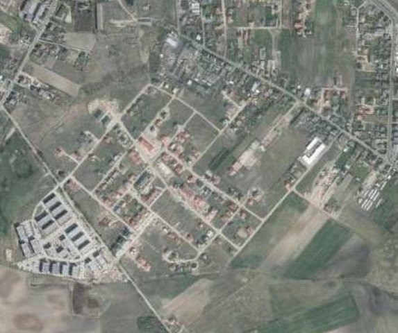
Aims / objectives: The aim of this approach is to show how spatial planning decisions, should be made by taking into account the soil sealing problem. As the consequence of urbanization pressure, the urban sprawl is crossing municipal boundaries of Poznań. In the whole study site area, 53,3 % are arable lands, located mostly on loams, silts or sandy clay soils. Wielkopolska province has got the highest farm productivity per ha in Poland. Based on EEA data, sealed surfaces constitute 16 % of the city area. Soil sealing problem is a consequence of the urban sprawl process, which affects mainly the municipalities near by the Poznań city borders. To support decision-making in municipalities spatial planning offices, the data from the soil sealing maps is used to select the most appropriate areas to build new houses mostly on low quality soils.
Methods: Land use maps of at least 10-meter resolution are produced for two historical periods
through classification of the satellite images and using available local land use
information. The information on land use change is superimposed on maps
characterizing soil quality in order to detect to what extend the urbanization took place
on valuable soils. The new sealed area, reflecting the built up sprawl of at least last 15
years, consists with expansion of the following land use classes: continuous residential
area, commercial/industrial area and transport facilities. The soils under these new land
use types fully lost their environmental functions. In the soil sealing forecasts the
Cellular Automata-based Metronamica model is used. The final maps consist of the spatial planning aspect, soil sealing area and the scientific comment about the soil sealing problem.
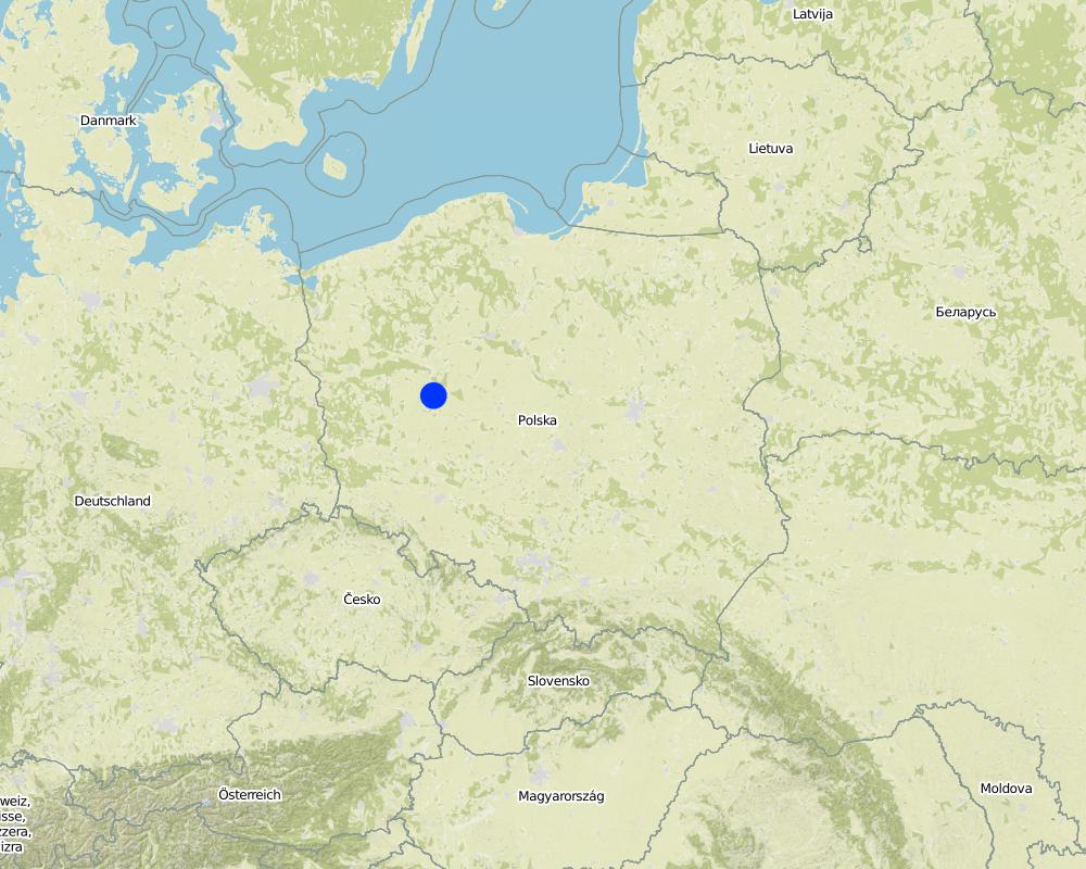
2.5 ประเทศ ภูมิภาค หรือสถานที่ตั้งที่ได้นำแนวทางไปใช้
ประเทศ:
โปแลนด์
ภูมิภาค/รัฐ/จังหวัด: :
Poland, Wielkopolska
ข้อมูลเฉพาะเพิ่มเติมของสถานที่ตั้ง:
Poznan
Map
×2.7 ประเภทของแนวทาง
- ใช้โครงงานหรือแผนงานเป็นฐาน
2.8 เป้าหมายหรือวัตถุประสงค์หลักของแนวทาง
The Approach focused on SLM only
The main aim of this Approach is to utilize soil agricultural maps and provide information on quality of sealed soils. Send those maps to the municipal authorities, with a scientific comment on the problem. For the whole province, these maps should be made based on the digital soil maps in scale 1:25 000.
The SLM Approach addressed the following problems: The best type of soil is being sealed by new house constructions sites. People from the city center are moving out to municipalities which are near by the border of the city. They are building their houses mostly on agricultural fields in a chaotic way, in much cases on the highest quality soils. This urban sprawl process, affects negatively the soil ecosystem services by the soil sealing and also decrease the quality of inhabitants life.
2.9 เงื่อนไขที่เอื้ออำนวยหรือเป็นอุปสรรคต่อการนำเทคโนโลยีภายใต้แนวทางนี้ไปปฏิบัติใช้
การจัดตั้งระดับองค์กร
- เป็นอุปสรรค
In Poland, for every area there were made soil maps in scale 1:5000 and 1:25000. On those maps besides soil data there is also information about house areas and land use types. Most of those maps are still only in paper version, which makes it very hard to use them in spatial planning.
Treatment through the SLM Approach: We will digitize the paper version of soil maps for the municipalities, and also update the map content about the land use.
3. การมีส่วนร่วมและบทบาทของผู้มีส่วนได้ส่วนเสียที่เกี่ยวข้อง
3.1 ผู้มีส่วนได้ส่วนเสียที่เกี่ยวข้องในแนวทางนี้และบทบาท
- ผู้เชี่ยวชาญ SLM หรือที่ปรึกษาการเกษตร
- รัฐบาลระดับท้องถิ่น
- รัฐบาลแห่งชาติ (ผู้วางแผน ผู้ทำการตัดสินใจ)
Wielkopolska province, the Office of spatial planning in Poznań
3.2 การเกี่ยวข้องของผู้ใช้ที่ดินระดับท้องถิ่นหรือชุมชนระดับท้องถิ่นในช่วงต่างๆของแนวทาง
| ความเกี่ยวข้องของผู้ใช้ที่ดินระดับท้องถิ่นหรือชุมชนระดับท้องถิ่น | ระบุผู้ที่มีส่วนเกี่ยวข้องและอธิบายกิจกรรม | |
|---|---|---|
| การริเริ่มหรือการจูงใจ | ไม่มี | The project was introduced throught RECARE project |
| การวางแผน | ปฏิสัมพันธ์ | Wielkopolska province, the Office of spatial planning in Poznań. They firstly had chosen in which municipalities there is the biggest soil sealing problem |
| การดำเนินการ | ไม่มี | Wielkopolska province, the Office of spatial planning in Poznań. It is implemented in the spatial planning strategy in the Wielkopolska province. |
| การติดตามตรวจสอบหรือการประเมินผล | ระดมกำลังด้วยตนเอง | Institute of soil science and plant cultivation in Pulawy. There is a discussion on a regular basis with the stakeholders. |
| Research | ไม่มี |
3.4 การตัดสินใจเลือกใช้เทคโนโลยี SLM
ระบุผู้ที่ทำการตัดสินใจเลือกเทคโนโลยีมากกว่าหนึ่งวิธีไปปฏิบัติใช้:
- ผู้เชี่ยวชาญ SLM เพียงผู้เดียว
การอธิบาย:
Decisions on the method of implementing the SLM Technology were made by by SLM specialists alone (top-down)
4. การสนับสนุนด้านเทคนิค การสร้างขีดความสามารถ และการจัดการด้านความรู้
4.1 การสร้างขีดความสามารถ / การอบรม
ได้มีการจัดอบรมให้แก่ผู้ใช้ที่ดินหรือผู้มีส่วนได้ส่วนเสียคนอื่น ๆ หรือไม่:
ใช่
- office workers form the Office of spatial planning
4.2 การบริการให้คำแนะนำ
ผู้ใช้ที่ดินมีการเข้าถึงการรับบริการให้คำปรึกษาหรือไม่:
ใช่
การอธิบาย/แสดงความคิดเห็น:
Advisory service is quite adequate to ensure the continuation of land conservation activities
4.3 การเสริมความแข็งแกร่งให้กับสถาบัน (การพัฒนาองค์กร)
สถาบันได้รับการจัดตั้งขึ้นมาหรือเสริมความแข็งแกร่งโดยแนวทางนี้หรือไม่:
- ใช่ เล็กน้อย
ระบุระดับของสถาบันที่ได้รับการเสริมความแข็งแกร่งหรือจัดตั้งขึ้นมา:
- ท้องถิ่น
ระบุประเภทของการให้ความช่วยเหลือสนับสนุน:
- การสร้างขีดความสามารถ / การอบรม
ให้รายละเอียดเพิ่มเติม :
On the first workshop.
4.4 การติดตามตรวจสอบและประเมินผล
การติดตามตรวจสอบและประเมินผลเป็นส่วนหนึ่งของแนวทางหรือไม่:
ใช่
ความคิดเห็น:
technical aspects were ad hoc monitored by government through observations; indicators: Advisory meetings
area treated aspects were ad hoc monitored by government through observations; indicators: only in municipalities with the highest soil sealing threat
management of Approach aspects were regular monitored by project staff through observations; indicators: advisory meetings
There were no changes in the Approach as a result of monitoring and evaluation
There were no changes in the Technology as a result of monitoring and evaluation
4.5 การวิจัย
การวิจัยเป็นส่วนหนึ่งของแนวทางหรือไม่:
ใช่
ระบุหัวข้อเรื่อง:
- เทคโนโลยี
ให้ข้อมูลเพิ่มเติมและให้ระบุผู้ทำการวิจัย:
Research was carried out on station
5. การสนับสนุนด้านการเงินและวัสดุอุปกรณ์
5.1 ระบุงบประมาณประจำปีสำหรับแนวทาง SLM นี้
แสดงความคิดเห็น (แหล่งของการระดมทุน ผู้บริจาคคนสำคัญ):
Approach costs were met by the following donors: international non-government: 90.0%; local government (district, county, municipality, village etc): 10.0%
5.4 เครดิต
มีการจัดหาเครดิตมาให้ภายใต้แนวทาง SLM หรือไม่:
ไม่ใช่
6. การวิเคราะห์ผลกระทบและการสรุป
6.1 ผลกระทบของแนวทาง
ช่วยให้ผู้ใช้ที่ดินนำเอาเทคโนโลยี SLMไปใช้และบำรุงรักษาสภาพไว้ได้หรือไม่:
- ไม่ใช่
- ใช่ เล็กน้อย
- ใช่ ปานกลาง
- ใช่ อย่างมาก
It had raised the awareness about the value of soil ecosystem services, and had shown how big is the scale of soil sealing. This information have started to be very useful in case of taking new spatial planning decisions by the planners.
ทำให้กลุ่มด้อยโอกาสมีอำนาจทางสังคมและเศรษฐกิจหรือไม่:
- ไม่ใช่
- ใช่ เล็กน้อย
- ใช่ ปานกลาง
- ใช่ อย่างมาก
This isn't connected with the soil sealing threat
ปรับปรุงประเด็นของการถือครองที่ดินหรือสิทธิในการใช้ ซึ่งขัดขวางการนำเทคโนโลยีไปใช้ให้ดีขึ้น:
- ไม่ใช่
- ใช่ เล็กน้อย
- ใช่ ปานกลาง
- ใช่ อย่างมาก
Did other land users / projects adopt the Approach?
- ไม่ใช่
- ใช่ เล็กน้อย
- ใช่ ปานกลาง
- ใช่ อย่างมาก
Our every stakeholder have adopted the Approach.
Did the Approach lead to improved livelihoods / human well-being?
- ไม่ใช่
- ใช่ เล็กน้อย
- ใช่ ปานกลาง
- ใช่ อย่างมาก
This isn't connected with the soil sealing threat
Did the Approach help to alleviate poverty?
- ไม่ใช่
- ใช่ เล็กน้อย
- ใช่ ปานกลาง
- ใช่ อย่างมาก
This isn't connected with the soil sealing threat
6.2 แรงจูงใจหลักของผู้ใช้ที่ดินเพื่อที่จะนำ SLM ไปปฏิบัติใช้
- จิตสำนึกด้านสิ่งแวดล้อม
6.3 ความยั่งยืนของกิจกรรมของแนวทาง
ผู้ใช้ที่ดินสามารถทำให้สิ่งต่างๆ ที่ได้ปฏิบัติใช้โดยแนวทางนี้ยั่งยืนได้หรือไม่ (โดยไม่มีการสนับสนุนจากภายนอก):
- ใช่
ถ้าตอบว่าใช่ ให้อธิบายว่าอย่างไร :
Yes, they can continue the Approach activities without support. But we are opened for cooperation/consulting if there will be a need to make some improvements in this Approach.
6.4 จุดแข็งและข้อได้เปรียบของแนวทาง
| จุดแข็ง / ข้อได้เปรียบของแนวทางในทัศนคติของผู้รวบรวมหรือวิทยากรหลัก |
|---|
| The analysis are made base on the low scale maps : 1:5000 and 1:25000. (How to sustain/ enhance this strength: Update the land use information in spatial data format) |
6.5 จุดอ่อน / ข้อเสียเปรียบของแนวทางและวิธีในการแก้ไข
| จุดอ่อน / ข้อเสียเปรียบในทัศนคติของผู้รวบรวมหรือวิทยากรหลัก | สามารถแก้ไขปัญหาได้อย่างไร |
|---|---|
| The commune authorities don't think about long therm consequences in soil loss. They don't see soil sealing as a threat. | Raise the awareness about soil ecosystem services, especially about soil sealing threat. Showing them on the maps, the results of various prediction model, in which the urban sprawl will be still uncontrolled. |
7. การอ้างอิงและการเชื่อมต่อ
7.1 วิธีการหรือแหล่งข้อมูล
- ไปเยี่ยมชมภาคสนาม การสำรวจพื้นที่ภาคสนาม
- การสัมภาษณ์กับผู้ใช้ที่ดิน
ลิงก์และโมดูล
ขยายทั้งหมด ย่อทั้งหมดลิงก์
Ex-post and ex-ante soil sealing maps [โปแลนด์]
Ex-post and ex-ante soil sealing maps
- ผู้รวบรวม: Tomasz Miturski
โมดูล
ไม่มีโมดูล