Water retention polders to improve water management [Germany]
- Creation:
- Update:
- Compiler: Martin Maier
- Editor: –
- Reviewers: Fabian Ottiger, David Streiff, Alexandra Gavilano
Polder zum Wassermanagement entwickelt durch lokale Experten (Nordsee Region)
technologies_1583 - Germany
View sections
Expand all Collapse all1. General information
1.2 Contact details of resource persons and institutions involved in the assessment and documentation of the Technology
Key resource person(s)
SLM specialist:
Kleyer Michael
University of Oldenburg
Germany
SLM specialist:
Karrasch Leena
University of Oldenburg
Germany
SLM specialist:
Mayer Martin
University of Oldenburg
Germany
Name of project which facilitated the documentation/ evaluation of the Technology (if relevant)
Book project: Making sense of research for sustainable land management (GLUES)Name of project which facilitated the documentation/ evaluation of the Technology (if relevant)
Sustainable Coastal Land Management (COMTESS / GLUES)Name of the institution(s) which facilitated the documentation/ evaluation of the Technology (if relevant)
University of Oldenburg (University of Oldenburg) - Germany1.3 Conditions regarding the use of data documented through WOCAT
The compiler and key resource person(s) accept the conditions regarding the use of data documented through WOCAT:
Ja
1.5 Reference to Questionnaire(s) on SLM Approaches (documented using WOCAT)
Stakeholder participation in integrated assessment and planning of … [Germany]
Stakeholders have been involved in integrated assessment to develop action-oriented land use options addressing possible climate change adaptation measures as alternatives to traditional coastal protection strategies.
- Compiler: Martin Maier
2. Description of the SLM Technology
2.1 Short description of the Technology
Definition of the Technology:
Water retaining polders to reduce flood risk due to heavy rainfall or runoff at high tide in embanked coastal lowlands. Delineation of the retention area and land use within the retention area was developed in a participatory process with local experts.
2.2 Detailed description of the Technology
Description:
In the 19th and 20th century land was reclaimed from the sea to make use of the exposed fertile soils for agriculture through a process known as ‘impoldering’. The reclaimed land is now characterized by intensive grazing and cropland. This is a region where agriculture is the most important form of land use. However, the land needs to be regularly drained. Given the expected increase in precipitation in winter due to climate change, the corresponding increase in freshwater discharge needs to be managed. Furthermore, the periods when natural discharge into the sea oc-curs are likely to decrease – because of rising sea levels also caused by climate change. Consequently, in winter and spring, greater quantities of freshwater will need to be pumped into the sea rather than discharged naturally at the low or ‘ebb’ tide. Specially embanked water retention polders will be required to temporarily impound water as part of a multifunctional approach to coastal zone management.
Purpose of the Technology: These retention polders could be a cost-effective alternative to expensive invest-ments in extra pumping capacities to prevent submergence of low-lying cultivated areas. The primary aim is to restrict floods to the retention polders when the drain-age network is overburdened and cannot deal with the predicted extra demands in the future. The high evapotranspiration from the open waterbody, and the reeds growing within, will also help with reducing the amount of water. During dry sum-mers, the water in the retention polder could also be put to creative use as a source of irrigation. Another potential advantage is that subsurface saltwater intrusion in the region could be prevented by the freshwater-filled polders. During extreme storm surges and in the rare case of breaches in the sea wall, the retention polders would serve as an extra line of defence by holding seawater.
Establishment / maintenance activities and inputs: An embankment enclosing approx. 500 ha will be able to store up to 2,500,000 m³ of water. This will improve the drainage of an area of approx. 49,000 ha. The invest-ment for building this water retention area is high – but for the reasons stated it serves a necessary purpose at a cost which is lower than the alternative – increased pumped drainage installations. Maintenance costs will be lower than the drainage alternative as only the integrity of the embankment needs to be monitored regularly. Currently, agricultural land use within the polders is adapted to higher water levels and occasional flooding. Within the embanked area there will be a change from the current use of mainly crop land to extensive grazing, open water and reed stands.
Natural / human environment: Some parts within the retention polder will be used for agricultural purposes, while the wetter parts will be set aside. In these latter sections, undisturbed natural regen-eration will take place. A landscape comprising various different elements, without any extreme forms of intensive land use such as large areas of monocultures will be the result. Thus requirements for agricultural use and tourism will be addressed.
2.3 Photos of the Technology
Media Gallery
2.5 Country/ region/ locations where the Technology has been applied and which are covered by this assessment
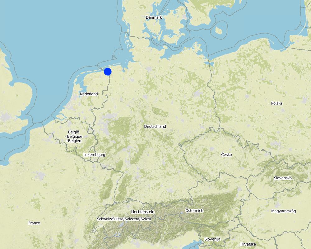
Country:
Germany
Region/ State/ Province:
Germany, Lower Saxony
Further specification of location:
Landkreis Aurich
Comments:
Total area covered by the SLM Technology is 33.7 km2.
Map
×2.6 Date of implementation
If precise year is not known, indicate approximate date:
- 10-50 years ago
2.7 Introduction of the Technology
Specify how the Technology was introduced:
- during experiments/ research
- through projects/ external interventions
3. Classification of the SLM Technology
3.2 Current land use type(s) where the Technology is applied
Land use mixed within the same land unit:
Ja
Specify mixed land use (crops/ grazing/ trees):
- Agro-pastoralism (incl. integrated crop-livestock)

Cropland

Grazing land
Intensive grazing/ fodder production:
- Cut-and-carry/ zero grazing
- Improved pastures
Animal type:
- cattle - dairy
- cattle - non-dairy beef
Products and services:
- meat
- milk
Comments:
Major land use problems (compiler’s opinion): Flood events and droughts may substantially disrupt the contemporary land use in the future and lead to higher drainage costs and higher economic risks for agricultural production. This may reduce the ecological and economic viability of the current intensive and highly productive land use under a changing climate.
Major land use problems (land users’ perception): There is no awareness of risks due to climate change in the land users point of view.
Cut-and-carry/ zero grazing: cows for milk
Improved pasture: cattle for milk and meat
Future (final) land use (after implementation of SLM Technology): Other: Oo: Other: wastelands, deserts, glaciers, swamps, recreation areas, etc
Constraints of infrastructure network (roads, railways, pipe lines, power lines): needs to be adapted to regular flooding
Constraints of recreation (landscape is used for recreation and tourism ): change in landscape due to retention area
Constraints of nature conservation area (protected sites): wetter conditions in retention area
Number of growing seasons per year: 1
Longest growing period in days: 240Longest growing period from month to month: March to October
Livestock density: > 100 LU /km2
3.3 Has land use changed due to the implementation of the Technology?
Has land use changed due to the implementation of the Technology?
- Yes (Please fill out the questions below with regard to the land use before implementation of the Technology)

Waterways, waterbodies, wetlands
- Swamps, wetlands

Unproductive land
Specify:
wastelands
Comments:
Mixed: Mp: Agro-pastoralism
3.4 Water supply
Comments:
Water supply: rainfed, mixed rainfed - irrigated
3.5 SLM group to which the Technology belongs
- surface water management (spring, river, lakes, sea)
- wetland protection/ management
- Flood prevention
3.6 SLM measures comprising the Technology

structural measures
- S5: Dams, pans, ponds

management measures
- M1: Change of land use type
- M2: Change of management/ intensity level
Comments:
Main measures: structural measures
Secondary measures: management measures
3.7 Main types of land degradation addressed by the Technology

chemical soil deterioration
- Cs: salinization/ alkalinization

water degradation
- Hs: change in quantity of surface water
- Hg: change in groundwater/aquifer level
- Hq: decline of groundwater quality
Comments:
Main type of degradation addressed: Hs: change in quantity of surface water
Secondary types of degradation addressed: Cs: salinisation / alkalinisation, Hg: change in groundwater / aquifer level, Hq: decline of groundwater quality
Main causes of degradation: change of seasonal rainfall (Climate change, higher rainfall in winter, lower in summer), Heavy / extreme rainfall (intensity/amounts) (Heavy rainfall in winter due to climate change expected), floods (Flooding due to heavy rainfall in winter)
Secondary causes of degradation: droughts (Droughts due to less rainfall in summer (climate change)), other natural causes (avalanches, volcanic eruptions, mud flows, highly susceptible natural resources, extreme topography, etc.) specify (Sea level rise)
3.8 Prevention, reduction, or restoration of land degradation
Specify the goal of the Technology with regard to land degradation:
- prevent land degradation
- reduce land degradation
Comments:
Main goals: prevention of land degradation
Secondary goals: mitigation / reduction of land degradation
4. Technical specifications, implementation activities, inputs, and costs
4.1 Technical drawing of the Technology
Technical specifications (related to technical drawing):
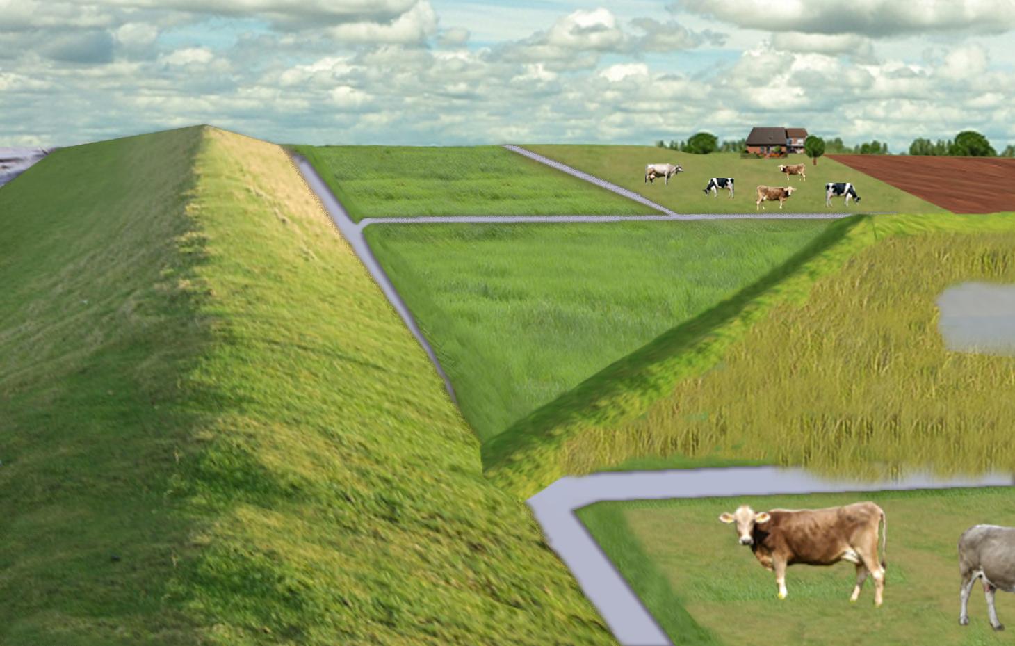
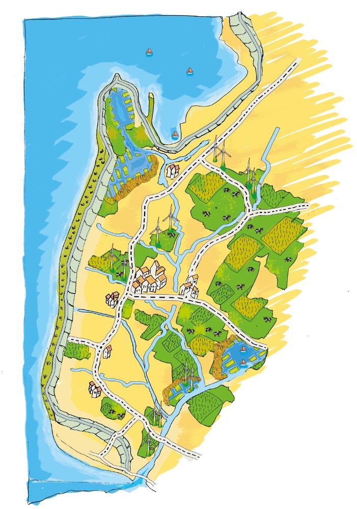
The figure shows the study region, located on the North Sea coast. The whole area is protected by a sea wall (grey). Crop fields (yellow), grasslands (green) and the drainage system (light blue) char-acterize the region. In contrast to T_GER001en and T_GER002en small water bodies (blue) surrounded by reeds (brown) act as water retention polders. Agricultural land use in some retention areas is adapted to the ground water levels and flooding frequencies. This results in parts of the retention areas being taken out of agricultural production and undisturbed development of natural habitats occurring. In other parts of the retention areas extensive grazing or reed farming will be practiced. This leads to a mosaic of different land uses in the landscape. Retention areas of 500 ha are able to store up to 2,500,000 m³ water. The height of the dams depends on the elevation of the landscape but in general a height of less than 2 m is sufficient.
Location: Krummhörn. County of Aurich, Lower Saxony
Technical knowledge required for field staff / advisors: high (To generate income in the retention area (without existing agricultural methods))
Technical knowledge required for water board: high (To build a new adapted drainage system with retention areas)
Main technical functions: control of dispersed runoff: retain / trap, control of concentrated runoff: retain / trap
Secondary technical functions: increase / maintain water stored in soil, increase of groundwater level / recharge of groundwater, spatial arrangement and diversification of land use
Dam/ pan/ pond
Height of bunds/banks/others (m): 1
Width of bunds/banks/others (m): 2
Length of bunds/banks/others (m): 13000
Construction material (earth): sand core and clay cover
Specification of dams/ pans/ ponds: Capacity 2500000m3
Catchment area: 49000ham2
Beneficial area: 49000ham2
Other specifications: size of retention area (embanked area): 500.00 ha
Change of land use type: Within the retention area the conditions are wetter than before. Therefore the agricultural land use needs to be changed to an adapted land use.
Change of land use practices / intensity level: Under the wetter conditions only a less intensive land use is possible, e.g. no crop fields but instead extensive grazing or cessation of agricultural land use.
Author:
Udo Schotten
4.2 General information regarding the calculation of inputs and costs
other/ national currency (specify):
Euro
If relevant, indicate exchange rate from USD to local currency (e.g. 1 USD = 79.9 Brazilian Real): 1 USD =:
0.94
Indicate average wage cost of hired labour per day:
100.00
4.3 Establishment activities
| Activity | Timing (season) | |
|---|---|---|
| 1. | Building of dams | during winter months |
4.4 Costs and inputs needed for establishment
| Specify input | Unit | Quantity | Costs per Unit | Total costs per input | % of costs borne by land users | |
|---|---|---|---|---|---|---|
| Labour | Labour | Dam | 1.0 | 10000000.0 | 10000000.0 | |
| Equipment | Machine use | Dam | 1.0 | 4000000.0 | 4000000.0 | |
| Construction material | Earth | Dam | 1.0 | 112000.0 | 112000.0 | |
| Total costs for establishment of the Technology | 14112000.0 | |||||
| Total costs for establishment of the Technology in USD | 15012765.96 | |||||
Comments:
Duration of establishment phase: 3 month(s)
4.5 Maintenance/ recurrent activities
| Activity | Timing/ frequency | |
|---|---|---|
| 1. | Control of dams | once a year |
| 2. | Maintenance of dams | once a year |
| 3. | Maintenance of drainage system | once a year (mean of many years) |
4.6 Costs and inputs needed for maintenance/ recurrent activities (per year)
| Specify input | Unit | Quantity | Costs per Unit | Total costs per input | % of costs borne by land users | |
|---|---|---|---|---|---|---|
| Labour | Labour | Dam | 1.0 | 500.0 | 500.0 | |
| Equipment | Machine use | Dam | 1.0 | 200.0 | 200.0 | |
| Construction material | Earth | Dam | 1.0 | 100.0 | 100.0 | |
| Other | Maintenance per km ditch | Dam | 1.0 | 2270.7 | 2270.7 | |
| Total costs for maintenance of the Technology | 3070.7 | |||||
| Total costs for maintenance of the Technology in USD | 3266.7 | |||||
Comments:
Machinery/ tools: digger, open truck
The main investment is based on a dam length of 13 km to build up the retention area of a size of 500 ha. The length of the drainage network for the whole watershed (retention area and the surroundings) is 1,134 km. Maintenance costs of drainage network are based on long term annual mean cost of 2,270.72 Euro per km including pumping costs.
4.7 Most important factors affecting the costs
Describe the most determinate factors affecting the costs:
The establishment costs are for the whole retention area (500 ha). The establishment period will be half a year.
Mainly the elevation in the region determines the costs as the height of the dams depend on the elevation. Typical heights are 1 m up to 2 m with a slope of 1:3.
5. Natural and human environment
5.1 Climate
Annual rainfall
- < 250 mm
- 251-500 mm
- 501-750 mm
- 751-1,000 mm
- 1,001-1,500 mm
- 1,501-2,000 mm
- 2,001-3,000 mm
- 3,001-4,000 mm
- > 4,000 mm
Agro-climatic zone
- humid
Thermal climate class: temperate
5.2 Topography
Slopes on average:
- flat (0-2%)
- gentle (3-5%)
- moderate (6-10%)
- rolling (11-15%)
- hilly (16-30%)
- steep (31-60%)
- very steep (>60%)
Landforms:
- plateau/plains
- ridges
- mountain slopes
- hill slopes
- footslopes
- valley floors
Altitudinal zone:
- 0-100 m a.s.l.
- 101-500 m a.s.l.
- 501-1,000 m a.s.l.
- 1,001-1,500 m a.s.l.
- 1,501-2,000 m a.s.l.
- 2,001-2,500 m a.s.l.
- 2,501-3,000 m a.s.l.
- 3,001-4,000 m a.s.l.
- > 4,000 m a.s.l.
5.3 Soils
Soil depth on average:
- very shallow (0-20 cm)
- shallow (21-50 cm)
- moderately deep (51-80 cm)
- deep (81-120 cm)
- very deep (> 120 cm)
Soil texture (topsoil):
- fine/ heavy (clay)
Topsoil organic matter:
- high (>3%)
If available, attach full soil description or specify the available information, e.g. soil type, soil PH/ acidity, Cation Exchange Capacity, nitrogen, salinity etc.
Soil fertility is high
Soil drainage/infiltration is meidum
Soil water storage capacity is high
5.4 Water availability and quality
Ground water table:
< 5 m
Availability of surface water:
good
Water quality (untreated):
for agricultural use only (irrigation)
5.5 Biodiversity
Species diversity:
- low
5.6 Characteristics of land users applying the Technology
Market orientation of production system:
- commercial/ market
Off-farm income:
- 10-50% of all income
Relative level of wealth:
- average
Individuals or groups:
- employee (company, government)
Level of mechanization:
- mechanized/ motorized
Gender:
- women
- men
Indicate other relevant characteristics of the land users:
Land users applying the Technology are mainly common / average land users
Population density: 50-100 persons/km2
Annual population growth: < 0.5%
1% of the land users are very rich and own 1% of the land.
49% of the land users are rich and own 24% of the land.
50% of the land users are average wealthy and own 50% of the land.
and own 25% of the land.
Off-farm income specification: Many farmers do additional work in companies
5.7 Average area of land used by land users applying the Technology
- < 0.5 ha
- 0.5-1 ha
- 1-2 ha
- 2-5 ha
- 5-15 ha
- 15-50 ha
- 50-100 ha
- 100-500 ha
- 500-1,000 ha
- 1,000-10,000 ha
- > 10,000 ha
Is this considered small-, medium- or large-scale (referring to local context)?
- large-scale
Comments:
Average area of land owned or leased by land users applying the Technology: 5-15 ha, 15-50 ha, 50-100 ha, 100-500 ha
5.8 Land ownership, land use rights, and water use rights
Land ownership:
- individual, not titled
Land use rights:
- individual
5.9 Access to services and infrastructure
health:
- poor
- moderate
- good
education:
- poor
- moderate
- good
technical assistance:
- poor
- moderate
- good
employment (e.g. off-farm):
- poor
- moderate
- good
markets:
- poor
- moderate
- good
energy:
- poor
- moderate
- good
roads and transport:
- poor
- moderate
- good
drinking water and sanitation:
- poor
- moderate
- good
financial services:
- poor
- moderate
- good
6. Impacts and concluding statements
6.1 On-site impacts the Technology has shown
Socio-economic impacts
Production
crop production
Comments/ specify:
Under wet conditions in the retention area a crop production is not possible any more.
fodder production
Comments/ specify:
Under wet conditions in the retention area an intensive fodder production is not possible any more.
fodder quality
Comments/ specify:
Under wet conditions in the retention area the optiomal fodder quality can not ensured any more.
risk of production failure
Comments/ specify:
Regarding crops: The retention area is used for excess water and may be flooded during growing season.
Income and costs
expenses on agricultural inputs
Comments/ specify:
Only adjusted land use takes place, therefore the expenses are reduced nearly to 0.
farm income
diversity of income sources
Comments/ specify:
Due to land use adapted to the conditions the typical land use is not possible and a diversitfication will take place with reed mowing and extensive grazing in the retention area.
Other socio-economic impacts
Intrusion by saline groundwater
Socio-cultural impacts
recreational opportunities
Comments/ specify:
Diversification of landscape by building the retention area will increase the attractivity for recreation and tourists.
SLM/ land degradation knowledge
Comments/ specify:
Less intensive land use results in more diversity and conservation of regional species and habitats.
conflict mitigation
Improved livelihoods and human well-being
Comments/ specify:
'Regional belonging' and 'feeling of safety' are measured. The amount of increase is modelled and will be added here.
Ecological impacts
Water cycle/ runoff
water quantity
Comments/ specify:
Typical for the region are wet situations. These typical wet conditions are restored by cessation of drainage system within the retention area.
water quality
Comments/ specify:
Updwelling of saline groundwater is prevented by increased water level in the retention area.
groundwater table/ aquifer
Comments/ specify:
By water in the retention are the recharge of groundwater will increase and prevent salinization.
evaporation
Comments/ specify:
Instead of pumping water into the sea a higher amount is evapotranspirated naturally.
Soil
soil moisture
Comments/ specify:
Typical for the region are wet situations. These typical wet conditions are restored by cessation of drainage system within the retention area.
salinity
Comments/ specify:
By water in the retention are the recharge of groundwater will increase and prevent salinization.
soil organic matter/ below ground C
Comments/ specify:
By wetter conditions the soil organic matter will be increased.
Biodiversity: vegetation, animals
plant diversity
Comments/ specify:
By diversification of land use the number of species will be increased, especially due to extensive land use.
animal diversity
Comments/ specify:
By diversification of land use the number of species will be increased, especially due to extensive land use.
habitat diversity
Comments/ specify:
By diversification of land use the number of habitats will be increased.
Climate and disaster risk reduction
emission of carbon and greenhouse gases
Comments/ specify:
Modelled is the global warming potential by gas emissions. Not yet clear if it is benefit or disadvantage. Model will show.
6.2 Off-site impacts the Technology has shown
water availability
reliable and stable stream flows in dry season
Comments/ specify:
Water stored in retention area can be used for irrigation during dry summer months.
downstream flooding
Comments/ specify:
Measured m3 of excess water in the catchment area, leading to floods or needs to be pumped. Exact values from modelling will be added as soon as possible!
damage on neighbours' fields
damage on public/ private infrastructure
Reduced hazard towards adverse events
6.3 Exposure and sensitivity of the Technology to gradual climate change and climate-related extremes/ disasters (as perceived by land users)
Gradual climate change
Gradual climate change
| Season | increase or decrease | How does the Technology cope with it? | |
|---|---|---|---|
| annual temperature | increase | well |
Climate-related extremes (disasters)
Meteorological disasters
| How does the Technology cope with it? | |
|---|---|
| local rainstorm | well |
| local windstorm | well |
Climatological disasters
| How does the Technology cope with it? | |
|---|---|
| drought | well |
Hydrological disasters
| How does the Technology cope with it? | |
|---|---|
| general (river) flood | well |
Other climate-related consequences
Other climate-related consequences
| How does the Technology cope with it? | |
|---|---|
| reduced growing period | not known |
6.4 Cost-benefit analysis
How do the benefits compare with the establishment costs (from land users’ perspective)?
Short-term returns:
negative
Long-term returns:
slightly positive
How do the benefits compare with the maintenance/ recurrent costs (from land users' perspective)?
Short-term returns:
slightly positive
Long-term returns:
very positive
Comments:
The benefits will be visible in an longer time frame. There will be benefits of the investments when considering sea level rise in the upcoming 100 years.
6.5 Adoption of the Technology
Comments:
Comments on spontaneous adoption: The SLM Technology is not implemented by land users but needs to be implemented in spatial planning of the federal state. We expect that there is a chance for implementation.
There is a strong trend towards spontaneous adoption of the Technology
Comments on adoption trend: The SLM Technology was developed together with regional experts. It seems that the ideas developed, merge more often in their recent discussion and an implementation is likely.
6.7 Strengths/ advantages/ opportunities of the Technology
| Strengths/ advantages/ opportunities in the land user’s view |
|---|
|
The retention area will supplement the drainage of the arable fields and pastures outside the retention area How can they be sustained / enhanced? Combine with other technical solutions for protection against flooding. |
| Strengths/ advantages/ opportunities in the compiler’s or other key resource person’s view |
|---|
|
Prevention of flooding during strong rainfalls and possibility to irrigate during dry periods How can they be sustained / enhanced? The larger the retention areas are the more water can be stored |
|
Prevention of salt water intrusion in the region How can they be sustained / enhanced? Fresh water in the retention areas prevents saline ground water from intrusion. Build polders in areas where saline ground water intrudes. |
|
Endangered species might obtain new habitats in the retention area How can they be sustained / enhanced? Extensive land use can help to optimize the habitats for endan-gered species and increase attractiveness for tourism. |
|
Through investments in building retention polders the very ex-pensive strengthening of the existing drainage system is no longer necessary. How can they be sustained / enhanced? By increasing the attractiveness for tourism alternative benefits for land owner can be generated. |
|
Multi-functional land use in the catchment and in the retention area How can they be sustained / enhanced? Support farmers with land in the retention area (e.g. financially or with additional agricultural land outside the retention area). Sup-port discussions between farmers’ associations and nature con-servation agencies. |
6.8 Weaknesses/ disadvantages/ risks of the Technology and ways of overcoming them
| Weaknesses/ disadvantages/ risks in the land user’s view | How can they be overcome? |
|---|---|
| The retention polders will change the landscape and this may reduce the value of the region for tourism | Include tourist concerns within the retention area (accessibility, information, attractiveness) |
| Endangered species might lose habitats when building up the retention polders | Do not build a retention area where endangered species live |
| Loss of livelihoods | Retention areas should be planned for parts of the landscape without settlements |
| Weaknesses/ disadvantages/ risks in the compiler’s or other key resource person’s view | How can they be overcome? |
|---|---|
| Loss of land for agricultural production | Create retention polders where the productivity is already low. Encourage alternative land use (for example reed production) in the retention polders. |
| High water levels (especially with changing levels) may generate high emissions of greenhouse gases. | Ground water levels should kept stable near to the soil surface. |
| Retention area is probably too small if pessimistic sea level rise predictions come true. | Increase size of retention polders. |
7. References and links
7.1 Methods/ sources of information
7.2 References to available publications
Title, author, year, ISBN:
http://www.comtess.uni-oldenburg.de/
7.3 Links to relevant online information
Title/ description:
http://www.comtess.uni-oldenburg.de/
Links and modules
Expand all Collapse allLinks
Stakeholder participation in integrated assessment and planning of … [Germany]
Stakeholders have been involved in integrated assessment to develop action-oriented land use options addressing possible climate change adaptation measures as alternatives to traditional coastal protection strategies.
- Compiler: Martin Maier
Modules
No modules