Water retention polders to improve water management [Герман]
- Шинийг нээх:
- Шинэчлэх:
- Эмхэтгэгч: Martin Maier
- Хянан тохиолдуулагч: –
- Хянагчид: Fabian Ottiger, David Streiff, Alexandra Gavilano
Polder zum Wassermanagement entwickelt durch lokale Experten (Nordsee Region)
technologies_1583 - Герман
Бүлгүүдийг үзэх
Бүгдийг дэлгэх Бүгдийг хаах1. Ерөнхий мэдээлэл
1.2 Технологийг үнэлэх, баримтжуулах ажилд хамаарах мэдээлэл өгсөн хүмүүс, байгууллагуудын холбоо барих мэдээлэл
Мэдээлэл өгсөн хүн (с)
ГТМ мэргэжилтэн:
Kleyer Michael
University of Oldenburg
Герман
ГТМ мэргэжилтэн:
Karrasch Leena
University of Oldenburg
Герман
ГТМ мэргэжилтэн:
Mayer Martin
University of Oldenburg
Герман
Технологи баримтжуулах/үнэлэх ажилд дэмжлэг үзүүлсэн төслийн нэр (шаардлагатай бол)
Book project: Making sense of research for sustainable land management (GLUES)Технологи баримтжуулах/үнэлэх ажилд дэмжлэг үзүүлсэн төслийн нэр (шаардлагатай бол)
Sustainable Coastal Land Management (COMTESS / GLUES)Технологи баримтжуулах/үнэлэх ажилд дэмжлэг үзүүлсэн байгууллага(ууд)-ын нэр (шаардлагатай бол)
University of Oldenburg (University of Oldenburg) - Герман1.3 ВОКАТ-аар баримтжуулсан өгөгдлийг ашиглахтай холбоотой нөхцөл
Эмхэтгэгч болон гол мэдээлэгч хүн(хүмүүс) WOCAT аргачлалаар баримтжуулсан мэдээллийг ашиглахтай холбоотой нөхцлийг хүлээн зөвшөөрсөн:
Тийм
1.5 ГТМ Арга барилын Асуулга (ууд) руу хандах (ВОКАТ ашиглан баримтжуулсан)
Stakeholder participation in integrated assessment and planning of … [Герман]
Stakeholders have been involved in integrated assessment to develop action-oriented land use options addressing possible climate change adaptation measures as alternatives to traditional coastal protection strategies.
- Эмхэтгэгч: Martin Maier
2. ГТМ Технологийн тодорхойлолт
2.1 Технологийн товч тодорхойлолт
Технологийн тодорхойлолт:
Water retaining polders to reduce flood risk due to heavy rainfall or runoff at high tide in embanked coastal lowlands. Delineation of the retention area and land use within the retention area was developed in a participatory process with local experts.
2.2 Технологийн дэлгэрэнгүй тодорхойлолт
Тодорхойлолт:
In the 19th and 20th century land was reclaimed from the sea to make use of the exposed fertile soils for agriculture through a process known as ‘impoldering’. The reclaimed land is now characterized by intensive grazing and cropland. This is a region where agriculture is the most important form of land use. However, the land needs to be regularly drained. Given the expected increase in precipitation in winter due to climate change, the corresponding increase in freshwater discharge needs to be managed. Furthermore, the periods when natural discharge into the sea oc-curs are likely to decrease – because of rising sea levels also caused by climate change. Consequently, in winter and spring, greater quantities of freshwater will need to be pumped into the sea rather than discharged naturally at the low or ‘ebb’ tide. Specially embanked water retention polders will be required to temporarily impound water as part of a multifunctional approach to coastal zone management.
Purpose of the Technology: These retention polders could be a cost-effective alternative to expensive invest-ments in extra pumping capacities to prevent submergence of low-lying cultivated areas. The primary aim is to restrict floods to the retention polders when the drain-age network is overburdened and cannot deal with the predicted extra demands in the future. The high evapotranspiration from the open waterbody, and the reeds growing within, will also help with reducing the amount of water. During dry sum-mers, the water in the retention polder could also be put to creative use as a source of irrigation. Another potential advantage is that subsurface saltwater intrusion in the region could be prevented by the freshwater-filled polders. During extreme storm surges and in the rare case of breaches in the sea wall, the retention polders would serve as an extra line of defence by holding seawater.
Establishment / maintenance activities and inputs: An embankment enclosing approx. 500 ha will be able to store up to 2,500,000 m³ of water. This will improve the drainage of an area of approx. 49,000 ha. The invest-ment for building this water retention area is high – but for the reasons stated it serves a necessary purpose at a cost which is lower than the alternative – increased pumped drainage installations. Maintenance costs will be lower than the drainage alternative as only the integrity of the embankment needs to be monitored regularly. Currently, agricultural land use within the polders is adapted to higher water levels and occasional flooding. Within the embanked area there will be a change from the current use of mainly crop land to extensive grazing, open water and reed stands.
Natural / human environment: Some parts within the retention polder will be used for agricultural purposes, while the wetter parts will be set aside. In these latter sections, undisturbed natural regen-eration will take place. A landscape comprising various different elements, without any extreme forms of intensive land use such as large areas of monocultures will be the result. Thus requirements for agricultural use and tourism will be addressed.
2.3 Технологийн гэрэл зураг
Медиа галерей
2.5 Энэ үнэлгээнд хамрагдсан технологийг хэрэгжүүлсэн улс орон/ бүс нутаг/ байршил
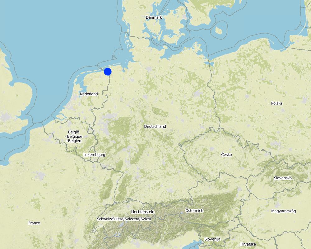
Улс:
Герман
Улс/аймаг/сум:
Germany, Lower Saxony
Байршлын дэлгэрэнгүй тодорхойлолт:
Landkreis Aurich
Тайлбар:
Total area covered by the SLM Technology is 33.7 km2.
Map
×2.6 Хэрэгжсэн хугацаа
Байгуулсан тодорхой оныг мэдэхгүй бол баримжаа хугацааг тодорхойл:
- 10-50 жилийн өмнө
2.7 Технологийн танилцуулга
Технологийг хэрхэн нэвтрүүлснийг тодорхойл:
- Туршилт/судалгааны үр дүн
- Гадны төсөл/хөтөлбөрийн дэмжлэгтэйгээр
3. ГТМ технологийн ангилал
3.2 Технологи нэвтрүүлсэн газрын одоогийн газар ашиглалтын хэлбэр(үүд)
Нэг газр нутгийн хэмжээнд хэрэгжих холимог газар ашиглалт:
Тийм
Газар ашиглалтын холимог тогтолцоог (тарилан/бэлчээр/ой мод) тодорхойл:
- Агро-бэлчээр (тарилан-мал аж ахуйн хослуулсан тогтолцоог хамруулан ойлгоно)

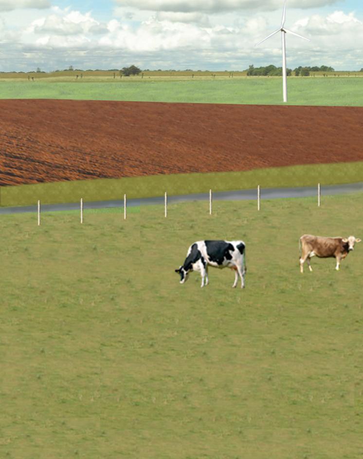
Тариалангийн талбай

Бэлчээрийн газар
Эрчимжсэн мал аж ахуй / тэжээл үйлдвэрлэл:
- Хадлан буюу бэлчээрт ашиглагдахгүй талбай
- Сайжруулсан бэлчээр
Амьтдын төрөл зүйл:
- үхрийн аж ахуй - цагаан идээ
- үхрийн аж ахуй - махны чиглэлийн үхэр
Бүтээгдэхүүн ба үйлчилгээ:
- мах
- сүү
Тайлбар:
Major land use problems (compiler’s opinion): Flood events and droughts may substantially disrupt the contemporary land use in the future and lead to higher drainage costs and higher economic risks for agricultural production. This may reduce the ecological and economic viability of the current intensive and highly productive land use under a changing climate.
Major land use problems (land users’ perception): There is no awareness of risks due to climate change in the land users point of view.
Cut-and-carry/ zero grazing: cows for milk
Improved pasture: cattle for milk and meat
Future (final) land use (after implementation of SLM Technology): Other: Oo: Other: wastelands, deserts, glaciers, swamps, recreation areas, etc
Constraints of infrastructure network (roads, railways, pipe lines, power lines): needs to be adapted to regular flooding
Constraints of recreation (landscape is used for recreation and tourism ): change in landscape due to retention area
Constraints of nature conservation area (protected sites): wetter conditions in retention area
Number of growing seasons per year: 1
Longest growing period in days: 240Longest growing period from month to month: March to October
Livestock density: > 100 LU /km2
3.3 Технологи хэрэгжүүлснээр газар ашиглалтад өөрчлөлт гарсан уу?
Технологи хэрэгжүүлснээр газар ашиглалтад өөрчлөлт гарсан уу?
- Тийм (Технологи хэрэгжүүлэхээс өмнөх үеийн газар ашиглалтын талаархи асуулгыг бөглөнө үү)

Усан зам, усан сан, ус намгархаг газар
- Намаг, ус намгархаг газар

Бүтээмжгүй газар
Тодорхойлно уу:
wastelands
Тайлбар:
Mixed: Mp: Agro-pastoralism
3.4 Усан хангамж
Тайлбар:
Water supply: rainfed, mixed rainfed - irrigated
3.5 Технологи ГТМ-ийн аль бүлэгт хамаарах вэ
- гадаргын усны менежмент (булаг, гол, нуур, тэнгис гэх мэт)
- Ус намгархаг газрын хамгаалал / менежмент
- Flood prevention
3.6 Технологийг бүрдүүлэх ГТМ арга хэмжээ

Барилга байгууламжийн арга хэмжээ
- S5: Далан, усан сан, цөөрөм

Менежментийн арга хэмжээ
- М1: Газар ашиглалтын хэлбэрийг өөрчлөх
- М2: Ашиглалтын менежмент/эрчимийг өөрчлөх
Тайлбар:
Main measures: structural measures
Secondary measures: management measures
3.7 Технологид харгалзах газрын доройтлын төрөл

хөрсний химийн доройтол
- Cs: Давсжилт / шүлтжилт

усны доройтол
- Hs: Гадаргын усны хэмжээ багасах
- Hg: Гүний ус / уст үеийн усны түвшин өөрчлөгдөх
- Hq: Гүний усны чанар муудах
Тайлбар:
Main type of degradation addressed: Hs: change in quantity of surface water
Secondary types of degradation addressed: Cs: salinisation / alkalinisation, Hg: change in groundwater / aquifer level, Hq: decline of groundwater quality
Main causes of degradation: change of seasonal rainfall (Climate change, higher rainfall in winter, lower in summer), Heavy / extreme rainfall (intensity/amounts) (Heavy rainfall in winter due to climate change expected), floods (Flooding due to heavy rainfall in winter)
Secondary causes of degradation: droughts (Droughts due to less rainfall in summer (climate change)), other natural causes (avalanches, volcanic eruptions, mud flows, highly susceptible natural resources, extreme topography, etc.) specify (Sea level rise)
3.8 Газрын доройтлоос урьдчилан сэргийлэх, сааруулах ба нөхөн сэргээх
Газрын доройтолтой холбоотойгоор Технологи ямар зорилго тавьсан болохыг тодорхойл:
- газрын доройтлоос урьдчилан сэргийлэх
- Газрын доройтлыг бууруулах
Тайлбар:
Main goals: prevention of land degradation
Secondary goals: mitigation / reduction of land degradation
4. Техникийн нөхцөл, хэрэгжүүлсэн үйл ажиллагаа, материал ба зардал
4.1 Технологийн техник зураг
Техник тодорхойлолт (техник зургийн тайлбар):
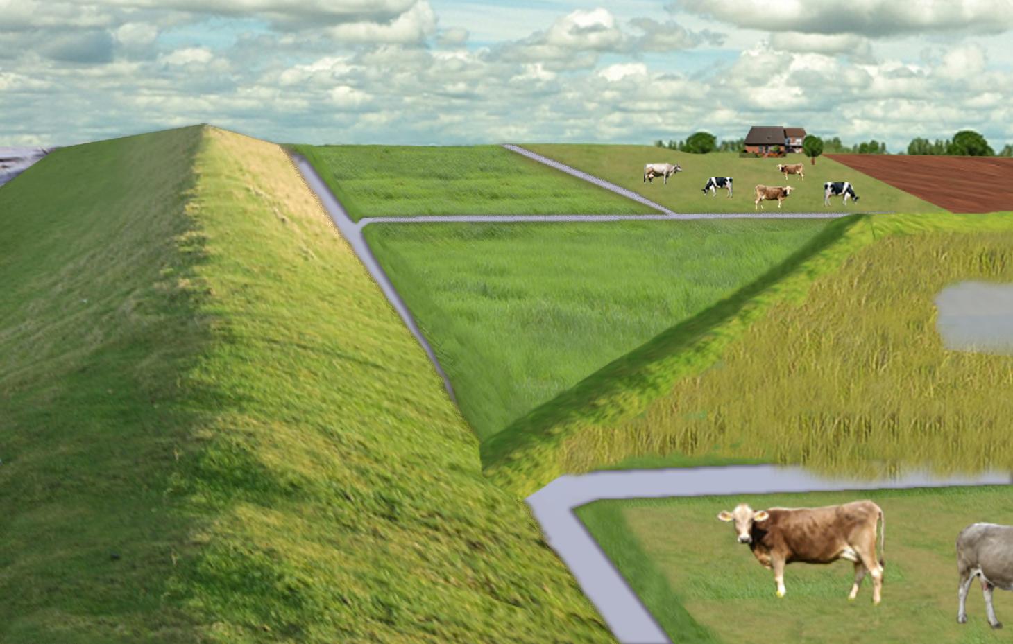
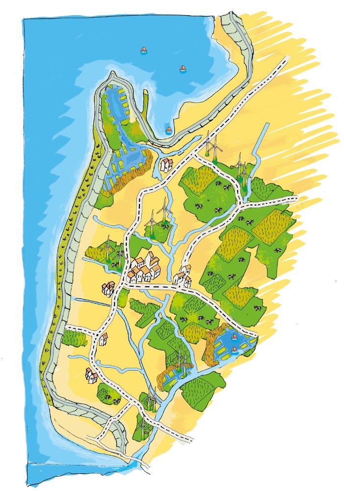
The figure shows the study region, located on the North Sea coast. The whole area is protected by a sea wall (grey). Crop fields (yellow), grasslands (green) and the drainage system (light blue) char-acterize the region. In contrast to T_GER001en and T_GER002en small water bodies (blue) surrounded by reeds (brown) act as water retention polders. Agricultural land use in some retention areas is adapted to the ground water levels and flooding frequencies. This results in parts of the retention areas being taken out of agricultural production and undisturbed development of natural habitats occurring. In other parts of the retention areas extensive grazing or reed farming will be practiced. This leads to a mosaic of different land uses in the landscape. Retention areas of 500 ha are able to store up to 2,500,000 m³ water. The height of the dams depends on the elevation of the landscape but in general a height of less than 2 m is sufficient.
Location: Krummhörn. County of Aurich, Lower Saxony
Technical knowledge required for field staff / advisors: high (To generate income in the retention area (without existing agricultural methods))
Technical knowledge required for water board: high (To build a new adapted drainage system with retention areas)
Main technical functions: control of dispersed runoff: retain / trap, control of concentrated runoff: retain / trap
Secondary technical functions: increase / maintain water stored in soil, increase of groundwater level / recharge of groundwater, spatial arrangement and diversification of land use
Dam/ pan/ pond
Height of bunds/banks/others (m): 1
Width of bunds/banks/others (m): 2
Length of bunds/banks/others (m): 13000
Construction material (earth): sand core and clay cover
Specification of dams/ pans/ ponds: Capacity 2500000m3
Catchment area: 49000ham2
Beneficial area: 49000ham2
Other specifications: size of retention area (embanked area): 500.00 ha
Change of land use type: Within the retention area the conditions are wetter than before. Therefore the agricultural land use needs to be changed to an adapted land use.
Change of land use practices / intensity level: Under the wetter conditions only a less intensive land use is possible, e.g. no crop fields but instead extensive grazing or cessation of agricultural land use.
Зохиогч:
Udo Schotten
4.2 Материал болон зардалд хамаарах ерөнхий мэдээлэл
бусад/үндэсний мөнгөн нэгж (тодорхойл):
Euro
Хэрэв боломжтой бол үндэсний валютын Америк доллартай харьцах харьцааг бичнэ үү (тухайлбал, 1 ам.дол. = 79,9 Бразил реал): 1 ам.дол. =:
0.94
Хөлсний ажилчны нэг өдрийн цалингийн хэмжээг тодорхойлно уу:
100.00
4.3 Бий болгох үйл ажиллагаа
| Үйл ажиллагаа | Хугацаа (улирал) | |
|---|---|---|
| 1. | Building of dams | during winter months |
4.4 Бий болгоход шаардагдсан зардал, хөрөнгийн өртөг
| Зардлын нэр, төрөл | Хэмжих нэгж | Тоо хэмжээ | Нэгжийн үнэ | Зардал бүрийн нийт өртөг | Нийт дүнгээс газар ашиглагчийн төлсөн % | |
|---|---|---|---|---|---|---|
| Хөдөлмөр эрхлэлт | Labour | Dam | 1.0 | 10000000.0 | 10000000.0 | |
| Тоног төхөөрөмж | Machine use | Dam | 1.0 | 4000000.0 | 4000000.0 | |
| Барилгын материал | Earth | Dam | 1.0 | 112000.0 | 112000.0 | |
| Технологи бий болгох нийт үнэ өртөг | 14112000.0 | |||||
| Технологи бий болгох нийт үнэ өртөг, ам.доллар | 15012765.96 | |||||
Тайлбар:
Duration of establishment phase: 3 month(s)
4.5 Арчилгаа/ урсгал үйл ажиллагаа
| Үйл ажиллагаа | Хугацаа/ давтамж | |
|---|---|---|
| 1. | Control of dams | once a year |
| 2. | Maintenance of dams | once a year |
| 3. | Maintenance of drainage system | once a year (mean of many years) |
4.6 Арчилгаа/урсгал ажилд шаардагдсан зардал, хөрөнгийн өртөг (нэг жилд)
| Зардлын нэр, төрөл | Хэмжих нэгж | Тоо хэмжээ | Нэгжийн үнэ | Зардал бүрийн нийт өртөг | Нийт дүнгээс газар ашиглагчийн төлсөн % | |
|---|---|---|---|---|---|---|
| Хөдөлмөр эрхлэлт | Labour | Dam | 1.0 | 500.0 | 500.0 | |
| Тоног төхөөрөмж | Machine use | Dam | 1.0 | 200.0 | 200.0 | |
| Барилгын материал | Earth | Dam | 1.0 | 100.0 | 100.0 | |
| Бусад | Maintenance per km ditch | Dam | 1.0 | 2270.7 | 2270.7 | |
| Технологийн арчилгаа/урсгал үйл ажиллагаанд шаардагдах нийт үнэ өртөг | 3070.7 | |||||
| Технологи арчилах ба урсгал ажлын нийт үнэ өртөг, ам.доллар | 3266.7 | |||||
Тайлбар:
Machinery/ tools: digger, open truck
The main investment is based on a dam length of 13 km to build up the retention area of a size of 500 ha. The length of the drainage network for the whole watershed (retention area and the surroundings) is 1,134 km. Maintenance costs of drainage network are based on long term annual mean cost of 2,270.72 Euro per km including pumping costs.
4.7 Зардалд нөлөөлж байгаа хамгийн чухал хүчин зүйл
Өртөг, зардалд нөлөөлөх гол хүчин зүйл:
The establishment costs are for the whole retention area (500 ha). The establishment period will be half a year.
Mainly the elevation in the region determines the costs as the height of the dams depend on the elevation. Typical heights are 1 m up to 2 m with a slope of 1:3.
5. Байгаль ба нийгмийн нөхцөл
5.1 Уур амьсгал
Жилийн нийлбэр хур тундас
- < 250 мм
- 251-500 мм
- 501-750 мм
- 751-1,000 мм
- 1,001-1,500 мм
- 1,501-2,000 мм
- 2,001-3,000 мм
- 3,001-4,000 мм
- > 4,000 мм
Агро-уур амьсгалын бүс
- чийглэг
Thermal climate class: temperate
5.2 Гадаргын хэлбэр
Дундаж налуу:
- хавтгай (0-2 %)
- бага зэрэг налуу (3-5 %)
- дунд зэрэг налуу (6-10 % )
- хэвгий (11-15 %)
- налуу (16-30 %)
- их налуу (31-60 % )
- эгц налуу (>60 %)
Гадаргын хэлбэр:
- тэгш өндөрлөг / тал
- нуруу
- уулын энгэр
- дов толгод
- бэл
- хөндий
Өндрийн бүслүүр:
- 0-100 д.т.д. м.
- 101-500 д.т.д. м.
- 501-1,000 д.т.д м.
- 1,001-1,500 д.т.д м.
- 1,501-2,000 д.т.д м.
- 2,001-2,500 д.т.д. м.
- 2,501-3,000 д.т.д. м.
- 3,001-4,000 д.т.д м.
- > 4,000 д.т.д. м.
5.3 Хөрс
Хөрсний дундаж зузаан:
- маш нимгэн (0-20 см)
- нимгэн (21-50 см)
- дунд зэрэг зузаан (51-80 см)
- зузаан (81-120 cм)
- маш зузаан (>120 cм)
Хөрсний бүтэц (өнгөн хөрс):
- нарийн /хүнд (шаварлаг)
Өнгөн хөрсөнд агуулагдах ялзмаг:
- их (>3 %)
Боломжтой бол хөрсний бүрэн тодорхойлолт, боломжит мэдээллийг өгнө үү, жишээ нь хөрсний төрөл, хөрсний урвалын орчин/хүчиллэг байдал, катион солилцох чадавхи, азотын хэмжээ, давсжилт г.м.
Soil fertility is high
Soil drainage/infiltration is meidum
Soil water storage capacity is high
5.4 Усны хүртээмж ба чанар
Гүний усны түвшин:
< 5 м
Гадаргын усны хүртээмж:
сайн
Усны чанар (цэвэршүүлээгүй):
зөвхөн газар тариалангийн зориулалтаар ашиглах (усалгаа)
5.5 Биологийн олон янз байдал
Зүйлийн олон янз байдал:
- Бага
5.6 Технологи нэвтрүүлсэн газар ашиглагчдын тухай мэдээлэл
Үйлдвэрлэлийн системийн зах зээлийн чиг баримжаа:
- худалдаа наймааны/ зах зээлийн
Бусад эх үүсвэрээс олох орлого:
- Нийт орлогын 10-50 %
Чинээлэг байдлын түвшин:
- дундаж
Хувь хүн эсвэл бүлэг:
- ажилтан (компани, засгийн газар)
Механикжилтын түвшин:
- механикжсан / мотортой
Хүйс:
- эмэгтэй
- эрэгтэй
Газар ашиглагчдын бусад шинж чанарыг тодорхойл:
Land users applying the Technology are mainly common / average land users
Population density: 50-100 persons/km2
Annual population growth: < 0.5%
1% of the land users are very rich and own 1% of the land.
49% of the land users are rich and own 24% of the land.
50% of the land users are average wealthy and own 50% of the land.
and own 25% of the land.
Off-farm income specification: Many farmers do additional work in companies
5.7 Газар ашиглагчийн технологи нэвтрүүлсэн газрын дундаж талбайн хэмжээ
- < 0.5 га
- 0.5-1 га
- 1-2 га
- 2-5 га
- 5-15 га
- 15-50 га
- 50-100 га
- 100-500 га
- 500-1,000 га
- 1,000-10,000 га
- > 10,000 га
Энэ талбай том, жижиг, дунд алинд хамаарах вэ (орон нутгийн нөхцөлд харгалзуулна уу)?
- том-хэмжээний
Тайлбар:
Average area of land owned or leased by land users applying the Technology: 5-15 ha, 15-50 ha, 50-100 ha, 100-500 ha
5.8 Газар эзэмшил, газар ашиглах эрх, ус ашиглах эрх
Газар өмчлөл:
- хувь хүн, өмчийн гэрчилгээгүй
Газар ашиглах эрх:
- хувь хүн
5.9 Дэд бүтэц, үйлчилгээний хүртээмж
эрүүл мэнд:
- ядуу
- дунд зэргийн
- сайн
боловсрол:
- ядуу
- дунд зэргийн
- сайн
техник зөвлөгөө:
- ядуу
- дунд зэргийн
- сайн
хөдөлмөр эрхлэлт (жишээ нь, ХАА-аас өөр):
- ядуу
- дунд зэргийн
- сайн
зах зээл:
- ядуу
- дунд зэргийн
- сайн
эрчим хүчний хангамж:
- ядуу
- дунд зэргийн
- сайн
зам тээвэр:
- ядуу
- дунд зэргийн
- сайн
усан хангамж ба ариутгал:
- ядуу
- дунд зэргийн
- сайн
санхүүгийн үйлчилгээ:
- ядуу
- дунд зэргийн
- сайн
6. Үр нөлөө ба дүгнэлт
6.1 Технологийн талбайд үзүүлсэн нөлөө
Нийгэм-эдийн засгийн үр нөлөө
Үйлдвэрлэл
газар тариалангийн үйлдвэрлэл
Тайлбар/ тодорхой дурьдах:
Under wet conditions in the retention area a crop production is not possible any more.
тэжээл үйлдвэрлэл
Тайлбар/ тодорхой дурьдах:
Under wet conditions in the retention area an intensive fodder production is not possible any more.
тэжээлийн чанар
Тайлбар/ тодорхой дурьдах:
Under wet conditions in the retention area the optiomal fodder quality can not ensured any more.
бүтээмж буурах эрсдэл
Тайлбар/ тодорхой дурьдах:
Regarding crops: The retention area is used for excess water and may be flooded during growing season.
Орлого, зарлага
ХАА-н зардал
Тайлбар/ тодорхой дурьдах:
Only adjusted land use takes place, therefore the expenses are reduced nearly to 0.
тухайн аж ахуйн орлого
орлогын олон янз эх үүсвэр
Тайлбар/ тодорхой дурьдах:
Due to land use adapted to the conditions the typical land use is not possible and a diversitfication will take place with reed mowing and extensive grazing in the retention area.
Нийгэм-эдийн засгийн бусад үр нөлөө
Intrusion by saline groundwater
Нийгэм-соёлын үр нөлөө
амралт, рекреацийн боломжууд
Тайлбар/ тодорхой дурьдах:
Diversification of landscape by building the retention area will increase the attractivity for recreation and tourists.
ГТМ/ газрын доройтлын мэдлэг
Тайлбар/ тодорхой дурьдах:
Less intensive land use results in more diversity and conservation of regional species and habitats.
маргааныг шийдвэрлэх
Improved livelihoods and human well-being
Тайлбар/ тодорхой дурьдах:
'Regional belonging' and 'feeling of safety' are measured. The amount of increase is modelled and will be added here.
Экологийн үр нөлөө
Усны эргэлт/ илүүдэл
усны хэмжээ
Тайлбар/ тодорхой дурьдах:
Typical for the region are wet situations. These typical wet conditions are restored by cessation of drainage system within the retention area.
усны чанар
Тайлбар/ тодорхой дурьдах:
Updwelling of saline groundwater is prevented by increased water level in the retention area.
гүний усны түвшин / уст давхарга
Тайлбар/ тодорхой дурьдах:
By water in the retention are the recharge of groundwater will increase and prevent salinization.
ууршилт
Тайлбар/ тодорхой дурьдах:
Instead of pumping water into the sea a higher amount is evapotranspirated naturally.
Хөрс
хөрсний чийг
Тайлбар/ тодорхой дурьдах:
Typical for the region are wet situations. These typical wet conditions are restored by cessation of drainage system within the retention area.
давсжилт
Тайлбар/ тодорхой дурьдах:
By water in the retention are the recharge of groundwater will increase and prevent salinization.
хөрсний органик нэгдэл/ хөрсөнд агуулагдах карбон
Тайлбар/ тодорхой дурьдах:
By wetter conditions the soil organic matter will be increased.
Биологийн олон янз байдал: ургамал, амьтан
ургамлын төрөл, зүйл
Тайлбар/ тодорхой дурьдах:
By diversification of land use the number of species will be increased, especially due to extensive land use.
амьтны төрөл, зүйл
Тайлбар/ тодорхой дурьдах:
By diversification of land use the number of species will be increased, especially due to extensive land use.
амьдрах орчны олон янз байдал
Тайлбар/ тодорхой дурьдах:
By diversification of land use the number of habitats will be increased.
Уур амьсгал болон гамшгийн эрсдлийг бууруулах
нүүрстөрөгч ба хүлэмжийн хийн ялгаруулалт
Тайлбар/ тодорхой дурьдах:
Modelled is the global warming potential by gas emissions. Not yet clear if it is benefit or disadvantage. Model will show.
6.2 Технологийн талбайн гадна үзүүлсэн үр нөлөө
Усны хүртээмж
хуурай улиралд ашиглах найдвартай, тогтвортой урсац
Тайлбар/ тодорхой дурьдах:
Water stored in retention area can be used for irrigation during dry summer months.
голын адагт үерлэх
Тайлбар/ тодорхой дурьдах:
Measured m3 of excess water in the catchment area, leading to floods or needs to be pumped. Exact values from modelling will be added as soon as possible!
хөрш зэргэлдээ газарт учирах хохирол
нийтийн/хувийн хэвшлийн дэд бүтцэд учрах хохирол
Reduced hazard towards adverse events
6.3 Технологийн уур амьсгалын өөрчлөлт, цаг агаарын гамшигт үзэгдэлд өртөх байдал ба эмзэг байдал (газар ашиглагчийн бодлоор)
Уур амьсгалын аажим өөрчлөлт
Уур амьсгалын аажим өөрчлөлт
| Улирал | Өсөх эсвэл буурах | Технологи түүний нөлөөг хэрхэн бууруулж байна? | |
|---|---|---|---|
| жилийн дундаж температур | Өсөлт | сайн |
Уур амьсгалаас хамаарах аюул (гамшиг)
Цаг уурын гамшигт үзэгдэл
| Технологи түүний нөлөөг хэрхэн бууруулж байна? | |
|---|---|
| орон нутгийн аадар бороо | сайн |
| орон нутгийн салхин шуурга | сайн |
Уур амьсгалын гамшиг
| Технологи түүний нөлөөг хэрхэн бууруулж байна? | |
|---|---|
| ган гачиг | сайн |
Усзүйн гамшиг
| Технологи түүний нөлөөг хэрхэн бууруулж байна? | |
|---|---|
| усны үер (гол) | сайн |
Уур амьсгалд хамаарах бусад үр дагавар
Уур амьсгалд хамаарах бусад үр дагавар
| Технологи түүний нөлөөг хэрхэн бууруулж байна? | |
|---|---|
| цргалтын хугацаа багасах | мэдэхгүй |
6.4 Өртөг ба ашгийн шинжилгээ
Бий болгох зардалтай харьцуулахад ямар ашиг өгсөн бэ (газар ашиглагчийн бодлоор)?
Богино хугацаанд эргэн төлөгдөх байдал:
сөрөг
Урт хугацаанд эргэн төлөгдөх байдал:
бага зэрэг эерэг
Арчилгаа/урсгал зардалтай харьцуулахад ямар ашиг өгсөн бэ (газар ашиглагчийн бодлоор)?
Богино хугацаанд эргэн төлөгдөх байдал:
бага зэрэг эерэг
Урт хугацаанд эргэн төлөгдөх байдал:
маш эерэг
Тайлбар:
The benefits will be visible in an longer time frame. There will be benefits of the investments when considering sea level rise in the upcoming 100 years.
6.5 Технологи нэвтрүүлэлт
Тайлбар:
Comments on spontaneous adoption: The SLM Technology is not implemented by land users but needs to be implemented in spatial planning of the federal state. We expect that there is a chance for implementation.
There is a strong trend towards spontaneous adoption of the Technology
Comments on adoption trend: The SLM Technology was developed together with regional experts. It seems that the ideas developed, merge more often in their recent discussion and an implementation is likely.
6.7 Технологийн давуу тал/боломжууд
| Газар ашиглагчдын тодорхойлсон давуу тал/боломжууд |
|---|
|
The retention area will supplement the drainage of the arable fields and pastures outside the retention area How can they be sustained / enhanced? Combine with other technical solutions for protection against flooding. |
| Эмхэтгэгч, бусад мэдээлэл өгсөн хүмүүсийн өнцгөөс тодорхойлсон давуу тал/боломжууд |
|---|
|
Prevention of flooding during strong rainfalls and possibility to irrigate during dry periods How can they be sustained / enhanced? The larger the retention areas are the more water can be stored |
|
Prevention of salt water intrusion in the region How can they be sustained / enhanced? Fresh water in the retention areas prevents saline ground water from intrusion. Build polders in areas where saline ground water intrudes. |
|
Endangered species might obtain new habitats in the retention area How can they be sustained / enhanced? Extensive land use can help to optimize the habitats for endan-gered species and increase attractiveness for tourism. |
|
Through investments in building retention polders the very ex-pensive strengthening of the existing drainage system is no longer necessary. How can they be sustained / enhanced? By increasing the attractiveness for tourism alternative benefits for land owner can be generated. |
|
Multi-functional land use in the catchment and in the retention area How can they be sustained / enhanced? Support farmers with land in the retention area (e.g. financially or with additional agricultural land outside the retention area). Sup-port discussions between farmers’ associations and nature con-servation agencies. |
6.8 Технологийн дутагдалтай/сул тал/аюул болон тэдгээрийг хэрхэн даван туулах арга зам
| Газар ашиглагч нарын тодорхойлсон сул тал/ дутагдал/ эрсдэл | Тэдгээрийг хэрхэн даван туулах вэ? |
|---|---|
| The retention polders will change the landscape and this may reduce the value of the region for tourism | Include tourist concerns within the retention area (accessibility, information, attractiveness) |
| Endangered species might lose habitats when building up the retention polders | Do not build a retention area where endangered species live |
| Loss of livelihoods | Retention areas should be planned for parts of the landscape without settlements |
| Эмхэтгэгч, бусад мэдээлэл өгсөн хүмүүсийн өнцгөөс тодорхойлсон сул тал/ дутагдал/ эрсдэл | Тэдгээрийг хэрхэн даван туулах вэ? |
|---|---|
| Loss of land for agricultural production | Create retention polders where the productivity is already low. Encourage alternative land use (for example reed production) in the retention polders. |
| High water levels (especially with changing levels) may generate high emissions of greenhouse gases. | Ground water levels should kept stable near to the soil surface. |
| Retention area is probably too small if pessimistic sea level rise predictions come true. | Increase size of retention polders. |
7. Ном зүй ба холбоосууд
7.1 Мэдээлэл цуглуулсан арга/эх үүсвэр
7.2 Ном, хэвлэлийн ишлэл
Гарчиг, зохиогч, он, ISBN:
http://www.comtess.uni-oldenburg.de/
7.3 Холбогдох мэдээллийн интернет холбоос
Гарчиг/ тодорхойлолт:
http://www.comtess.uni-oldenburg.de/
Холбоос ба модулууд
Бүгдийг дэлгэх Бүгдийг хаахХолбоосууд
Stakeholder participation in integrated assessment and planning of … [Герман]
Stakeholders have been involved in integrated assessment to develop action-oriented land use options addressing possible climate change adaptation measures as alternatives to traditional coastal protection strategies.
- Эмхэтгэгч: Martin Maier
Модулууд
Модуль байхгүй байна