Water retention polders to improve water management [เยอรมนี]
- ผู้สร้างสรรค์:
- การอัพเดท:
- ผู้รวบรวม: Martin Maier
- ผู้เรียบเรียง: –
- ผู้ตรวจสอบ: Fabian Ottiger, David Streiff, Alexandra Gavilano
Polder zum Wassermanagement entwickelt durch lokale Experten (Nordsee Region)
technologies_1583 - เยอรมนี
ดูส่วนย่อย
ขยายทั้งหมด ย่อทั้งหมด1. ข้อมูลทั่วไป
1.2 รายละเอียดที่ติดต่อได้ของผู้รวบรวมและองค์กรที่เกี่ยวข้องในการประเมินและการจัดเตรียมทำเอกสารของเทคโนโลยี
วิทยากรหลัก
ผู้เชี่ยวชาญ SLM:
Kleyer Michael
University of Oldenburg
เยอรมนี
ผู้เชี่ยวชาญ SLM:
Karrasch Leena
University of Oldenburg
เยอรมนี
ผู้เชี่ยวชาญ SLM:
Mayer Martin
University of Oldenburg
เยอรมนี
ชื่อของโครงการซึ่งอำนวยความสะดวกในการทำเอกสารหรือการประเมินเทคโนโลยี (ถ้าเกี่ยวข้อง)
Book project: Making sense of research for sustainable land management (GLUES)ชื่อของโครงการซึ่งอำนวยความสะดวกในการทำเอกสารหรือการประเมินเทคโนโลยี (ถ้าเกี่ยวข้อง)
Sustainable Coastal Land Management (COMTESS / GLUES)ชื่อขององค์กรซึ่งอำนวยความสะดวกในการทำเอกสารหรือการประเมินเทคโนโลยี (ถ้าเกี่ยวข้อง)
University of Oldenburg (University of Oldenburg) - เยอรมนี1.3 เงื่อนไขการใช้ข้อมูลที่ได้บันทึกผ่านทาง WOCAT
ผู้รวบรวมและวิทยากรหลักยอมรับเงื่อนไขเกี่ยวกับการใช้ข้อมูลที่ถูกบันทึกผ่านทาง WOCAT:
ใช่
1.5 Reference to Questionnaire(s) on SLM Approaches (documented using WOCAT)
Stakeholder participation in integrated assessment and planning of … [เยอรมนี]
Stakeholders have been involved in integrated assessment to develop action-oriented land use options addressing possible climate change adaptation measures as alternatives to traditional coastal protection strategies.
- ผู้รวบรวม: Martin Maier
2. การอธิบายลักษณะของเทคโนโลยี SLM
2.1 การอธิบายแบบสั้น ๆ ของเทคโนโลยี
คำจำกัดความของเทคโนโลยี:
Water retaining polders to reduce flood risk due to heavy rainfall or runoff at high tide in embanked coastal lowlands. Delineation of the retention area and land use within the retention area was developed in a participatory process with local experts.
2.2 การอธิบายแบบละเอียดของเทคโนโลยี
คำอธิบาย:
In the 19th and 20th century land was reclaimed from the sea to make use of the exposed fertile soils for agriculture through a process known as ‘impoldering’. The reclaimed land is now characterized by intensive grazing and cropland. This is a region where agriculture is the most important form of land use. However, the land needs to be regularly drained. Given the expected increase in precipitation in winter due to climate change, the corresponding increase in freshwater discharge needs to be managed. Furthermore, the periods when natural discharge into the sea oc-curs are likely to decrease – because of rising sea levels also caused by climate change. Consequently, in winter and spring, greater quantities of freshwater will need to be pumped into the sea rather than discharged naturally at the low or ‘ebb’ tide. Specially embanked water retention polders will be required to temporarily impound water as part of a multifunctional approach to coastal zone management.
Purpose of the Technology: These retention polders could be a cost-effective alternative to expensive invest-ments in extra pumping capacities to prevent submergence of low-lying cultivated areas. The primary aim is to restrict floods to the retention polders when the drain-age network is overburdened and cannot deal with the predicted extra demands in the future. The high evapotranspiration from the open waterbody, and the reeds growing within, will also help with reducing the amount of water. During dry sum-mers, the water in the retention polder could also be put to creative use as a source of irrigation. Another potential advantage is that subsurface saltwater intrusion in the region could be prevented by the freshwater-filled polders. During extreme storm surges and in the rare case of breaches in the sea wall, the retention polders would serve as an extra line of defence by holding seawater.
Establishment / maintenance activities and inputs: An embankment enclosing approx. 500 ha will be able to store up to 2,500,000 m³ of water. This will improve the drainage of an area of approx. 49,000 ha. The invest-ment for building this water retention area is high – but for the reasons stated it serves a necessary purpose at a cost which is lower than the alternative – increased pumped drainage installations. Maintenance costs will be lower than the drainage alternative as only the integrity of the embankment needs to be monitored regularly. Currently, agricultural land use within the polders is adapted to higher water levels and occasional flooding. Within the embanked area there will be a change from the current use of mainly crop land to extensive grazing, open water and reed stands.
Natural / human environment: Some parts within the retention polder will be used for agricultural purposes, while the wetter parts will be set aside. In these latter sections, undisturbed natural regen-eration will take place. A landscape comprising various different elements, without any extreme forms of intensive land use such as large areas of monocultures will be the result. Thus requirements for agricultural use and tourism will be addressed.
2.3 รูปภาพของเทคโนโลยี
อัลบั้มสื่อบันทึก
2.5 ประเทศภูมิภาค หรือสถานที่ตั้งที่เทคโนโลยีได้นำไปใช้และได้รับการครอบคลุมโดยการประเมินนี้
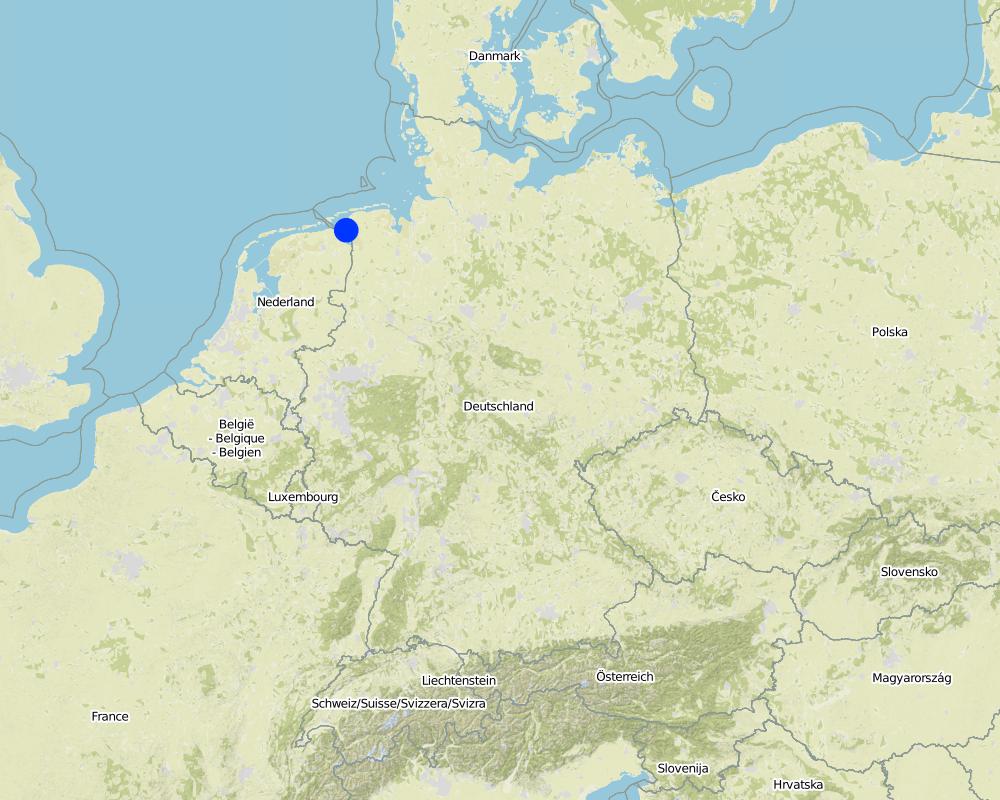
ประเทศ:
เยอรมนี
ภูมิภาค/รัฐ/จังหวัด:
Germany, Lower Saxony
ข้อมูลจำเพาะเพิ่มเติมของสถานที่ตั้ง :
Landkreis Aurich
แสดงความคิดเห็น:
Total area covered by the SLM Technology is 33.7 km2.
Map
×2.6 วันที่การดำเนินการ
ถ้าไม่รู้ปีที่แน่นอน ให้ระบุวันที่โดยประมาณ:
- 10-50 ปี
2.7 คำแนะนำของเทคโนโลยี
ให้ระบุว่าเทคโนโลยีถูกแนะนำเข้ามาอย่างไร:
- ในช่วงการทดลองหรือการทำวิจัย
- ทางโครงการหรือจากภายนอก
3. การจัดประเภทของเทคโนโลยี SLM
3.2 ประเภทของการใช้ที่ดินในปัจจุบันที่ได้นำเทคโนโลยีไปใช้
Land use mixed within the same land unit:
ใช่
Specify mixed land use (crops/ grazing/ trees):
- Agro-pastoralism (incl. integrated crop-livestock)

พื้นที่ปลูกพืช

ทุ่งหญ้าเลี้ยงสัตว์
ทุ่งหญ้าเลี้ยงสัตว์ที่มีการจัดการแบบเข้มข้นหรือการผลิตอาหารสัตว์:
- ตัดแล้วขนไป / ไม่มีการปล่อยแทะเล็มเอง (Cut-and-carry / zero grazing)
- ทุ่งหญ้าเลี้ยงสัตว์ที่ได้มีการปรับปรุง (Improved pastures)
Animal type:
- cattle - dairy
- cattle - non-dairy beef
ผลิตภัณฑ์และบริการ:
- meat
- milk
แสดงความคิดเห็น:
Major land use problems (compiler’s opinion): Flood events and droughts may substantially disrupt the contemporary land use in the future and lead to higher drainage costs and higher economic risks for agricultural production. This may reduce the ecological and economic viability of the current intensive and highly productive land use under a changing climate.
Major land use problems (land users’ perception): There is no awareness of risks due to climate change in the land users point of view.
Cut-and-carry/ zero grazing: cows for milk
Improved pasture: cattle for milk and meat
Future (final) land use (after implementation of SLM Technology): Other: Oo: Other: wastelands, deserts, glaciers, swamps, recreation areas, etc
Constraints of infrastructure network (roads, railways, pipe lines, power lines): needs to be adapted to regular flooding
Constraints of recreation (landscape is used for recreation and tourism ): change in landscape due to retention area
Constraints of nature conservation area (protected sites): wetter conditions in retention area
Number of growing seasons per year: 1
Longest growing period in days: 240Longest growing period from month to month: March to October
Livestock density: > 100 LU /km2
3.3 Has land use changed due to the implementation of the Technology?
Has land use changed due to the implementation of the Technology?
- Yes (Please fill out the questions below with regard to the land use before implementation of the Technology)

ทางน้ำ แหล่งน้ำ พื้นที่ชุ่มน้ำ
- หนองบึง พื้นที่ชุ่มน้ำ

ที่ดินที่ไม่ให้ผลผลิต
ระบุ:
wastelands
แสดงความคิดเห็น:
Mixed: Mp: Agro-pastoralism
3.4 การใช้น้ำ
แสดงความคิดเห็น:
Water supply: rainfed, mixed rainfed - irrigated
3.5 กลุ่ม SLM ที่ตรงกับเทคโนโลยีนี้
- การจัดการน้ำผิวดิน (น้ำพุ แม่น้ำทะเลสาบ ทะเล)
- การป้องกัน / การจัดการพื้นที่ชุ่มน้ำ
- Flood prevention
3.6 มาตรการ SLM ที่ประกอบกันเป็นเทคโนโลยี

มาตรการอนุรักษ์ด้วยโครงสร้าง
- S5: เขื่อน ชั้นดินที่แน่นแข็งบ่อน้ำ

มาตรการอนุรักษ์ด้วยการจัดการ
- M1: การเปลี่ยนรูปแบบของการใช้ประโยชน์ที่ดิน
- M2: การเปลี่ยนแปลงของการจัดการหรือระดับความเข้มข้น
แสดงความคิดเห็น:
Main measures: structural measures
Secondary measures: management measures
3.7 รูปแบบหลักของการเสื่อมโทรมของที่ดินที่ได้รับการแก้ไขโดยเทคโนโลยี

การเสื่อมโทรมของดินทางด้านเคมี
- Cs (Salinization/alkalinization): การสะสมเกลือหรือการทำให้เป็นด่าง

การเสื่อมโทรมของน้ำ
- Hs (Change in quantity of surface water): การเปลี่ยนแปลงปริมาณของน้ำที่ผิวดิน
- Hg (Change in groundwater): การเปลี่ยนแปลงของน้ำบาดาลหรือระดับน้ำในแอ่งน้ำบาดาล
- Hq (Decline of groundwater quality): การลดลงของคุณภาพน้ำบาดาล
แสดงความคิดเห็น:
Main type of degradation addressed: Hs: change in quantity of surface water
Secondary types of degradation addressed: Cs: salinisation / alkalinisation, Hg: change in groundwater / aquifer level, Hq: decline of groundwater quality
Main causes of degradation: change of seasonal rainfall (Climate change, higher rainfall in winter, lower in summer), Heavy / extreme rainfall (intensity/amounts) (Heavy rainfall in winter due to climate change expected), floods (Flooding due to heavy rainfall in winter)
Secondary causes of degradation: droughts (Droughts due to less rainfall in summer (climate change)), other natural causes (avalanches, volcanic eruptions, mud flows, highly susceptible natural resources, extreme topography, etc.) specify (Sea level rise)
3.8 การป้องกัน การลดลง หรือการฟื้นฟูความเสื่อมโทรมของที่ดิน
ระบุเป้าหมายของเทคโนโลยีกับความเสื่อมโทรมของที่ดิน:
- ป้องกันความเสื่อมโทรมของที่ดิน
- ลดความเสื่อมโทรมของดิน
แสดงความคิดเห็น:
Main goals: prevention of land degradation
Secondary goals: mitigation / reduction of land degradation
4. ข้อมูลจำเพาะด้านเทคนิค กิจกรรมการนำไปปฏิบัติใช้ ปัจจัยนำเข้า และค่าใช้จ่าย
4.1 แบบแปลนทางเทคนิคของเทคโนโลยี
ข้อมูลจำเพาะด้านเทคนิค (แบบแปลนทางเทคนิคของเทคโนโลยี):
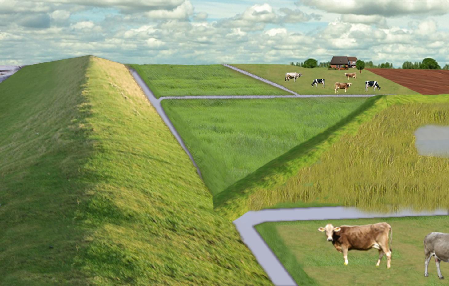
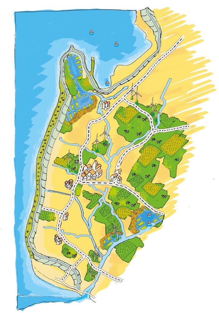
The figure shows the study region, located on the North Sea coast. The whole area is protected by a sea wall (grey). Crop fields (yellow), grasslands (green) and the drainage system (light blue) char-acterize the region. In contrast to T_GER001en and T_GER002en small water bodies (blue) surrounded by reeds (brown) act as water retention polders. Agricultural land use in some retention areas is adapted to the ground water levels and flooding frequencies. This results in parts of the retention areas being taken out of agricultural production and undisturbed development of natural habitats occurring. In other parts of the retention areas extensive grazing or reed farming will be practiced. This leads to a mosaic of different land uses in the landscape. Retention areas of 500 ha are able to store up to 2,500,000 m³ water. The height of the dams depends on the elevation of the landscape but in general a height of less than 2 m is sufficient.
Location: Krummhörn. County of Aurich, Lower Saxony
Technical knowledge required for field staff / advisors: high (To generate income in the retention area (without existing agricultural methods))
Technical knowledge required for water board: high (To build a new adapted drainage system with retention areas)
Main technical functions: control of dispersed runoff: retain / trap, control of concentrated runoff: retain / trap
Secondary technical functions: increase / maintain water stored in soil, increase of groundwater level / recharge of groundwater, spatial arrangement and diversification of land use
Dam/ pan/ pond
Height of bunds/banks/others (m): 1
Width of bunds/banks/others (m): 2
Length of bunds/banks/others (m): 13000
Construction material (earth): sand core and clay cover
Specification of dams/ pans/ ponds: Capacity 2500000m3
Catchment area: 49000ham2
Beneficial area: 49000ham2
Other specifications: size of retention area (embanked area): 500.00 ha
Change of land use type: Within the retention area the conditions are wetter than before. Therefore the agricultural land use needs to be changed to an adapted land use.
Change of land use practices / intensity level: Under the wetter conditions only a less intensive land use is possible, e.g. no crop fields but instead extensive grazing or cessation of agricultural land use.
ผู้เขียน:
Udo Schotten
4.2 ข้อมูลทั่วไปเกี่ยวกับการคำนวณปัจจัยนำเข้าและค่าใช้จ่าย
อื่นๆ หรือสกุลเงินประจำชาติ (ระบุ):
Euro
If relevant, indicate exchange rate from USD to local currency (e.g. 1 USD = 79.9 Brazilian Real): 1 USD =:
0.94
ระบุค่าเฉลี่ยของค่าจ้างในการจ้างแรงงานต่อวัน:
100.00
4.3 กิจกรรมเพื่อการจัดตั้ง
| กิจกรรม | Timing (season) | |
|---|---|---|
| 1. | Building of dams | during winter months |
4.4 ค่าใช้จ่ายของปัจจัยนำเข้าที่จำเป็นสำหรับการจัดตั้ง
| ปัจจัยนำเข้า | หน่วย | ปริมาณ | ค่าใช้จ่ายต่อหน่วย | ค่าใช้จ่ายทั้งหมดต่อปัจจัยนำเข้า | %ของค่าใช้จ่ายที่ก่อให้เกิดขึ้นโดยผู้ใช้ที่ดิน | |
|---|---|---|---|---|---|---|
| แรงงาน | Labour | Dam | 1.0 | 10000000.0 | 10000000.0 | |
| อุปกรณ์ | Machine use | Dam | 1.0 | 4000000.0 | 4000000.0 | |
| วัสดุสำหรับก่อสร้าง | Earth | Dam | 1.0 | 112000.0 | 112000.0 | |
| ค่าใช้จ่ายทั้งหมดของการจัดตั้งเทคโนโลยี | 14112000.0 | |||||
| Total costs for establishment of the Technology in USD | 15012765.96 | |||||
แสดงความคิดเห็น:
Duration of establishment phase: 3 month(s)
4.5 การบำรุงรักษาสภาพหรือกิจกรรมที่เกิดขึ้นเป็นประจำ
| กิจกรรม | ช่วงระยะเวลา/ความถี่ | |
|---|---|---|
| 1. | Control of dams | once a year |
| 2. | Maintenance of dams | once a year |
| 3. | Maintenance of drainage system | once a year (mean of many years) |
4.6 ค่าใช้จ่ายของปัจจัยนำเข้าและกิจกรรมที่เกิดขึ้นเป็นประจำที่ต้องการการบำรุงรักษา (ต่อปี)
| ปัจจัยนำเข้า | หน่วย | ปริมาณ | ค่าใช้จ่ายต่อหน่วย | ค่าใช้จ่ายทั้งหมดต่อปัจจัยนำเข้า | %ของค่าใช้จ่ายที่ก่อให้เกิดขึ้นโดยผู้ใช้ที่ดิน | |
|---|---|---|---|---|---|---|
| แรงงาน | Labour | Dam | 1.0 | 500.0 | 500.0 | |
| อุปกรณ์ | Machine use | Dam | 1.0 | 200.0 | 200.0 | |
| วัสดุสำหรับก่อสร้าง | Earth | Dam | 1.0 | 100.0 | 100.0 | |
| อื่น ๆ | Maintenance per km ditch | Dam | 1.0 | 2270.7 | 2270.7 | |
| ค่าใช้จ่ายทั้งหมดของการบำรุงรักษาสภาพเทคโนโลยี | 3070.7 | |||||
| Total costs for maintenance of the Technology in USD | 3266.7 | |||||
แสดงความคิดเห็น:
Machinery/ tools: digger, open truck
The main investment is based on a dam length of 13 km to build up the retention area of a size of 500 ha. The length of the drainage network for the whole watershed (retention area and the surroundings) is 1,134 km. Maintenance costs of drainage network are based on long term annual mean cost of 2,270.72 Euro per km including pumping costs.
4.7 ปัจจัยสำคัญที่สุดที่มีผลกระทบต่อค่าใช้จ่าย
ปัจจัยสำคัญที่สุดที่มีผลกระทบต่อค่าใช้จ่ายต่างๆ:
The establishment costs are for the whole retention area (500 ha). The establishment period will be half a year.
Mainly the elevation in the region determines the costs as the height of the dams depend on the elevation. Typical heights are 1 m up to 2 m with a slope of 1:3.
5. สิ่งแวดล้อมทางธรรมชาติและของมนุษย์
5.1 ภูมิอากาศ
ฝนประจำปี
- < 250 ม.ม.
- 251-500 ม.ม.
- 501-750 ม.ม.
- 751-1,000 ม.ม.
- 1,001-1,500 ม.ม.
- 1,501-2,000 ม.ม.
- 2,001-3,000 ม.ม.
- 3,001-4,000 ม.ม.
- > 4,000 ม.ม.
เขตภูมิอากาศเกษตร
- ชื้น
Thermal climate class: temperate
5.2 สภาพภูมิประเทศ
ค่าเฉลี่ยความลาดชัน:
- ราบเรียบ (0-2%)
- ลาดที่ไม่ชัน (3-5%)
- ปานกลาง (6-10%)
- เป็นลูกคลื่น (11-15%)
- เป็นเนิน (16-30%)
- ชัน (31-60%)
- ชันมาก (>60%)
ธรณีสัณฐาน:
- ที่ราบสูง/ที่ราบ
- สันเขา
- ไหล่เขา
- ไหล่เนินเขา
- ตีนเนิน
- หุบเขา
ระดับความสูง:
- 0-100 เมตร
- 101-500 เมตร
- 501-1,000 เมตร
- 1,001-1,500 เมตร
- 1,501-2,000 เมตร
- 2,001-2,500 เมตร
- 2,501-3,000 เมตร
- 3,001-4,000 เมตร
- > 4,000 เมตร
5.3 ดิน
ค่าเฉลี่ยความลึกของดิน:
- ตื้นมาก (0-20 ซ.ม.)
- ตื้น (21-50 ซ.ม.)
- ลึกปานกลาง (51-80 ซ.ม.)
- ลึก (81-120 ซ.ม.)
- ลึกมาก (>120 ซ.ม.)
เนื้อดิน (ดินชั้นบน):
- ละเอียด/หนัก (ดินเหนียว)
อินทรียวัตถุในดิน:
- สูง (>3%)
(ถ้ามี) ให้แนบคำอธิบายเรื่องดินแบบเต็มหรือระบุข้อมูลที่มีอยู่ เช่น ชนิดของดิน ค่า pH ของดินหรือความเป็นกรดของดิน ความสามารถในการแลกเปลี่ยนประจุบวก ไนโตรเจน ความเค็ม เป็นต้น:
Soil fertility is high
Soil drainage/infiltration is meidum
Soil water storage capacity is high
5.4 ความเป็นประโยชน์และคุณภาพของน้ำ
ระดับน้ำใต้ดิน:
<5 เมตร
น้ำไหลบ่าที่ผิวดิน:
ดี
คุณภาพน้ำ (ที่ยังไม่ได้บำบัด):
เป็นน้ำใช้เพื่อการเกษตรเท่านั้น (การชลประทาน)
5.5 ความหลากหลายทางชีวภาพ
ความหลากหลายทางชนิดพันธุ์:
- ต่ำ
5.6 ลักษณะของผู้ใช้ที่ดินที่นำเทคโนโลยีไปปฏิบัติใช้
แนวทางการตลาดของระบบการผลิต:
- ทำการค้า/การตลาด
รายได้ที่มาจากนอกฟาร์ม:
- 10-50% ของรายได้ทั้งหมด
ระดับของความมั่งคั่งโดยเปรียบเทียบ:
- พอมีพอกิน
เป็นรายบุคคล/ครัวเรือน:
- ลูกจ้าง (บริษัท รัฐบาล)
ระดับของการใช้เครื่องจักรกล:
- การใช้เครื่องจักรหรือเครื่องยนต์
เพศ:
- หญิง
- ชาย
ระบุลักษณะอื่นๆที่เกี่ยวข้องของผู้ใช้ที่ดิน:
Land users applying the Technology are mainly common / average land users
Population density: 50-100 persons/km2
Annual population growth: < 0.5%
1% of the land users are very rich and own 1% of the land.
49% of the land users are rich and own 24% of the land.
50% of the land users are average wealthy and own 50% of the land.
and own 25% of the land.
Off-farm income specification: Many farmers do additional work in companies
5.7 Average area of land used by land users applying the Technology
- < 0.5 เฮกตาร์
- 0.5-1 เฮกตาร์
- 1-2 เฮกตาร์
- 2-5 เฮกตาร์
- 5-15 เฮกตาร์
- 15-50 เฮกตาร์
- 50-100 เฮกตาร์
- 100-500 เฮกตาร์
- 500-1,000 เฮกตาร์
- 1,000-10,000 เฮกตาร์
- >10,000 เฮกตาร์
พิจารณาว่าเป็นขนาดเล็ก กลาง หรือขนาดใหญ่ (ซึ่งอ้างอิงถึงบริบทระดับท้องถิ่น):
- ขนาดใหญ่
แสดงความคิดเห็น:
Average area of land owned or leased by land users applying the Technology: 5-15 ha, 15-50 ha, 50-100 ha, 100-500 ha
5.8 กรรมสิทธิ์ในที่ดิน สิทธิในการใช้ที่ดินและสิทธิในการใช้น้ำ
กรรมสิทธิ์ในที่ดิน:
- รายบุคคล ไม่ได้รับสิทธิครอบครอง
สิทธิในการใช้ที่ดิน:
- รายบุคคล
5.9 การเข้าถึงบริการและโครงสร้างพื้นฐาน
สุขภาพ:
- จน
- ปานกลาง
- ดี
การศึกษา:
- จน
- ปานกลาง
- ดี
ความช่วยเหลือทางด้านเทคนิค:
- จน
- ปานกลาง
- ดี
การจ้างงาน (เช่น ภายนอกฟาร์ม):
- จน
- ปานกลาง
- ดี
ตลาด:
- จน
- ปานกลาง
- ดี
พลังงาน:
- จน
- ปานกลาง
- ดี
ถนนและการขนส่ง:
- จน
- ปานกลาง
- ดี
น้ำดื่มและการสุขาภิบาล:
- จน
- ปานกลาง
- ดี
บริการด้านการเงิน:
- จน
- ปานกลาง
- ดี
6. ผลกระทบและสรุปคำบอกกล่าว
6.1 ผลกระทบในพื้นที่ดำเนินการ (On-site) จากการใช้เทคโนโลยี
ผลกระทบทางด้านเศรษฐกิจและสังคม
การผลิต
การผลิตพืชผล
แสดงความคิดเห็น/ระบุ:
Under wet conditions in the retention area a crop production is not possible any more.
การผลิตพืชที่ใช้เลี้ยงปศุสัตว์
แสดงความคิดเห็น/ระบุ:
Under wet conditions in the retention area an intensive fodder production is not possible any more.
คุณภาพพืชที่ใช้เลี้ยงปศุสัตว์
แสดงความคิดเห็น/ระบุ:
Under wet conditions in the retention area the optiomal fodder quality can not ensured any more.
การเสี่ยงต่อความล้มเหลวในการผลิต
แสดงความคิดเห็น/ระบุ:
Regarding crops: The retention area is used for excess water and may be flooded during growing season.
รายได้และค่าใช้จ่าย
ค่าใช่จ่ายของปัจจัยการผลิตทางการเกษตร
แสดงความคิดเห็น/ระบุ:
Only adjusted land use takes place, therefore the expenses are reduced nearly to 0.
รายได้จากฟาร์ม
ความหลากหลายของแหล่งผลิตรายได้
แสดงความคิดเห็น/ระบุ:
Due to land use adapted to the conditions the typical land use is not possible and a diversitfication will take place with reed mowing and extensive grazing in the retention area.
ผลกระทบทางด้านเศรษฐกิจและสังคมอื่น ๆ
Intrusion by saline groundwater
ผลกระทบด้านสังคมวัฒนธรรมอื่น ๆ
โอกาสทางด้านสันทนาการ
แสดงความคิดเห็น/ระบุ:
Diversification of landscape by building the retention area will increase the attractivity for recreation and tourists.
SLM หรือความรู้เรื่องความเสื่อมโทรมของที่ดิน
แสดงความคิดเห็น/ระบุ:
Less intensive land use results in more diversity and conservation of regional species and habitats.
การบรรเทาความขัดแย้ง
Improved livelihoods and human well-being
แสดงความคิดเห็น/ระบุ:
'Regional belonging' and 'feeling of safety' are measured. The amount of increase is modelled and will be added here.
ผลกระทบด้านนิเวศวิทยา
วัฐจักรน้ำหรือน้ำบ่า
ปริมาณน้ำ
แสดงความคิดเห็น/ระบุ:
Typical for the region are wet situations. These typical wet conditions are restored by cessation of drainage system within the retention area.
คุณภาพน้ำ
แสดงความคิดเห็น/ระบุ:
Updwelling of saline groundwater is prevented by increased water level in the retention area.
น้ำบาดาลหรือระดับน้ำในแอ่งน้ำบาดาล
แสดงความคิดเห็น/ระบุ:
By water in the retention are the recharge of groundwater will increase and prevent salinization.
การระเหย
แสดงความคิดเห็น/ระบุ:
Instead of pumping water into the sea a higher amount is evapotranspirated naturally.
ดิน
ความชื้นในดิน
แสดงความคิดเห็น/ระบุ:
Typical for the region are wet situations. These typical wet conditions are restored by cessation of drainage system within the retention area.
ความเค็ม
แสดงความคิดเห็น/ระบุ:
By water in the retention are the recharge of groundwater will increase and prevent salinization.
อินทรียวัตถุในดิน/ต่ำกว่าดินชั้น C
แสดงความคิดเห็น/ระบุ:
By wetter conditions the soil organic matter will be increased.
ความหลากหลายทางชีวภาพของพืชและสัตว์
ความหลากหลายทางชีวภาพของพืช
แสดงความคิดเห็น/ระบุ:
By diversification of land use the number of species will be increased, especially due to extensive land use.
ความหลากหลายทางชีวภาพของสัตว์
แสดงความคิดเห็น/ระบุ:
By diversification of land use the number of species will be increased, especially due to extensive land use.
ความหลากหลายของสัตว์
แสดงความคิดเห็น/ระบุ:
By diversification of land use the number of habitats will be increased.
ลดความเสี่ยงของภัยพิบัติ
การปล่อยคาร์บอนและก๊าซเรือนกระจก
แสดงความคิดเห็น/ระบุ:
Modelled is the global warming potential by gas emissions. Not yet clear if it is benefit or disadvantage. Model will show.
6.2 ผลกระทบนอกพื้นที่ดำเนินการ (Off-site) จากการใช้เทคโนโลยี
น้ำที่ใช้ประโยชน์ได้
การไหลของน้ำคงที่และสม่ำเสมอในช่วงฤดูแล้ง
แสดงความคิดเห็น/ระบุ:
Water stored in retention area can be used for irrigation during dry summer months.
น้ำท่วมพื้นที่ท้ายน้ำ
แสดงความคิดเห็น/ระบุ:
Measured m3 of excess water in the catchment area, leading to floods or needs to be pumped. Exact values from modelling will be added as soon as possible!
ความเสียหายต่อพื้นที่เพาะปลูกของเพื่อนบ้าน
ความเสียหายต่อโครงสร้างพื้นฐานของรัฐหรือของเอกชน
Reduced hazard towards adverse events
6.3 การเผชิญและความตอบสนองของเทคโนโลยีต่อการเปลี่ยนแปลงสภาพภูมิอากาศที่ค่อยเป็นค่อยไป และสภาพรุนแรงของภูมิอากาศ / ภัยพิบัติ (ที่รับรู้ได้โดยผู้ใช้ที่ดิน)
การเปลี่ยนแปลงสภาพภูมิอากาศที่ค่อยเป็นค่อยไป
การเปลี่ยนแปลงสภาพภูมิอากาศที่ค่อยเป็นค่อยไป
| ฤดู | increase or decrease | เทคโนโลยีมีวิธีการรับมืออย่างไร | |
|---|---|---|---|
| อุณหภูมิประจำปี | เพิ่มขึ้น | ดี |
สภาพรุนแรงของภูมิอากาศ (ภัยพิบัติ)
ภัยพิบัติทางอุตุนิยมวิทยา
| เทคโนโลยีมีวิธีการรับมืออย่างไร | |
|---|---|
| พายุฝนประจำท้องถิ่น | ดี |
| พายุลมประจำท้องถิ่น | ดี |
ภัยพิบัติจากสภาพภูมิอากาศ
| เทคโนโลยีมีวิธีการรับมืออย่างไร | |
|---|---|
| ภัยจากฝนแล้ง | ดี |
ภัยพิบัติจากน้ำ
| เทคโนโลยีมีวิธีการรับมืออย่างไร | |
|---|---|
| น้ำท่วมตามปกติ (แม่น้ำ) | ดี |
ผลลัพธ์ตามมาที่เกี่ยวข้องกับภูมิอากาศอื่น ๆ
ผลลัพธ์ตามมาที่เกี่ยวข้องกับภูมิอากาศอื่น ๆ
| เทคโนโลยีมีวิธีการรับมืออย่างไร | |
|---|---|
| ช่วงการปลูกพืชที่ลดลงมา | ไม่ทราบ |
6.4 การวิเคราะห์ค่าใช้จ่ายและผลประโยชน์ที่ได้รับ
ผลประโยชน์ที่ได้รับเปรียบเทียบกับค่าใช้จ่ายในการจัดตั้งเป็นอย่างไร (จากมุมมองของผู้ใช้ที่ดิน)
ผลตอบแทนระยะสั้น:
ด้านลบ
ผลตอบแทนระยะยาว:
ด้านบวกเล็กน้อย
ผลประโยชน์ที่ได้รับเปรียบเทียบกับค่าใช้จ่ายในการบำรุงรักษาหรือต้นทุนที่เกิดขึ้นซ้ำอีก เป็นอย่างไร (จากมุมมองของผู้ใช้ที่ดิน)
ผลตอบแทนระยะสั้น:
ด้านบวกเล็กน้อย
ผลตอบแทนระยะยาว:
ด้านบวกอย่างมาก
แสดงความคิดเห็น:
The benefits will be visible in an longer time frame. There will be benefits of the investments when considering sea level rise in the upcoming 100 years.
6.5 การปรับตัวของเทคโนโลยี
แสดงความคิดเห็น:
Comments on spontaneous adoption: The SLM Technology is not implemented by land users but needs to be implemented in spatial planning of the federal state. We expect that there is a chance for implementation.
There is a strong trend towards spontaneous adoption of the Technology
Comments on adoption trend: The SLM Technology was developed together with regional experts. It seems that the ideas developed, merge more often in their recent discussion and an implementation is likely.
6.7 จุดแข็ง / ข้อได้เปรียบ / โอกาสของเทคโนโลยี
| จุดแข็ง / ข้อได้เปรียบ / โอกาสในทัศนคติของผู้ใช้ที่ดิน |
|---|
|
The retention area will supplement the drainage of the arable fields and pastures outside the retention area How can they be sustained / enhanced? Combine with other technical solutions for protection against flooding. |
| จุดแข็ง / ข้อได้เปรียบ / โอกาสในทัศนคติของผู้รวบรวมหรือวิทยากรหลัก |
|---|
|
Prevention of flooding during strong rainfalls and possibility to irrigate during dry periods How can they be sustained / enhanced? The larger the retention areas are the more water can be stored |
|
Prevention of salt water intrusion in the region How can they be sustained / enhanced? Fresh water in the retention areas prevents saline ground water from intrusion. Build polders in areas where saline ground water intrudes. |
|
Endangered species might obtain new habitats in the retention area How can they be sustained / enhanced? Extensive land use can help to optimize the habitats for endan-gered species and increase attractiveness for tourism. |
|
Through investments in building retention polders the very ex-pensive strengthening of the existing drainage system is no longer necessary. How can they be sustained / enhanced? By increasing the attractiveness for tourism alternative benefits for land owner can be generated. |
|
Multi-functional land use in the catchment and in the retention area How can they be sustained / enhanced? Support farmers with land in the retention area (e.g. financially or with additional agricultural land outside the retention area). Sup-port discussions between farmers’ associations and nature con-servation agencies. |
6.8 จุดอ่อน / ข้อเสียเปรียบ / ความเสี่ยงของเทคโนโลยีและวิธีการแก้ไข
| จุดอ่อน / ข้อเสียเปรียบ / ความเสี่ยงในทัศนคติของผู้ใช้ที่ดิน | มีวิธีการแก้ไขได้อย่างไร |
|---|---|
| The retention polders will change the landscape and this may reduce the value of the region for tourism | Include tourist concerns within the retention area (accessibility, information, attractiveness) |
| Endangered species might lose habitats when building up the retention polders | Do not build a retention area where endangered species live |
| Loss of livelihoods | Retention areas should be planned for parts of the landscape without settlements |
| จุดอ่อน / ข้อเสียเปรียบ / ความเสี่ยงในทัศนคติของผู้รวบรวมหรือวิทยากรหลัก | มีวิธีการแก้ไขได้อย่างไร |
|---|---|
| Loss of land for agricultural production | Create retention polders where the productivity is already low. Encourage alternative land use (for example reed production) in the retention polders. |
| High water levels (especially with changing levels) may generate high emissions of greenhouse gases. | Ground water levels should kept stable near to the soil surface. |
| Retention area is probably too small if pessimistic sea level rise predictions come true. | Increase size of retention polders. |
7. การอ้างอิงและการเชื่อมต่อ
7.1 วิธีการและแหล่งข้อมูล
7.2 การอ้างอิงถึงสิ่งตีพิมพ์
หัวข้อ, ผู้เขียน, ปี, หมายเลข ISBN:
http://www.comtess.uni-oldenburg.de/
7.3 Links to relevant online information
ชื่อเรื่องหรือคำอธิบาย:
http://www.comtess.uni-oldenburg.de/
ลิงก์และโมดูล
ขยายทั้งหมด ย่อทั้งหมดลิงก์
Stakeholder participation in integrated assessment and planning of … [เยอรมนี]
Stakeholders have been involved in integrated assessment to develop action-oriented land use options addressing possible climate change adaptation measures as alternatives to traditional coastal protection strategies.
- ผู้รวบรวม: Martin Maier
โมดูล
ไม่มีโมดูล