Water retention polders to improve water management [Allemagne]
- Création :
- Mise à jour :
- Compilateur : Martin Maier
- Rédacteur : –
- Examinateurs : Fabian Ottiger, David Streiff, Alexandra Gavilano
Polder zum Wassermanagement entwickelt durch lokale Experten (Nordsee Region)
technologies_1583 - Allemagne
Voir les sections
Développer tout Réduire tout1. Informations générales
1.2 Coordonnées des personnes-ressources et des institutions impliquées dans l'évaluation et la documentation de la Technologie
Personne(s)-ressource(s) clé(s)
Spécialiste GDT:
Kleyer Michael
University of Oldenburg
Allemagne
Spécialiste GDT:
Karrasch Leena
University of Oldenburg
Allemagne
Spécialiste GDT:
Mayer Martin
University of Oldenburg
Allemagne
Nom du projet qui a facilité la documentation/ l'évaluation de la Technologie (si pertinent)
Book project: Making sense of research for sustainable land management (GLUES)Nom du projet qui a facilité la documentation/ l'évaluation de la Technologie (si pertinent)
Sustainable Coastal Land Management (COMTESS / GLUES)Nom du ou des institutions qui ont facilité la documentation/ l'évaluation de la Technologie (si pertinent)
University of Oldenburg (University of Oldenburg) - Allemagne1.3 Conditions relatives à l'utilisation par WOCAT des données documentées
Le compilateur et la(les) personne(s) ressource(s) acceptent les conditions relatives à l'utilisation par WOCAT des données documentées:
Oui
1.5 Référence au(x) Questionnaires sur les Approches de GDT (documentées au moyen de WOCAT)
Stakeholder participation in integrated assessment and planning of … [Allemagne]
Stakeholders have been involved in integrated assessment to develop action-oriented land use options addressing possible climate change adaptation measures as alternatives to traditional coastal protection strategies.
- Compilateur : Martin Maier
2. Description de la Technologie de GDT
2.1 Courte description de la Technologie
Définition de la Technologie:
Water retaining polders to reduce flood risk due to heavy rainfall or runoff at high tide in embanked coastal lowlands. Delineation of the retention area and land use within the retention area was developed in a participatory process with local experts.
2.2 Description détaillée de la Technologie
Description:
In the 19th and 20th century land was reclaimed from the sea to make use of the exposed fertile soils for agriculture through a process known as ‘impoldering’. The reclaimed land is now characterized by intensive grazing and cropland. This is a region where agriculture is the most important form of land use. However, the land needs to be regularly drained. Given the expected increase in precipitation in winter due to climate change, the corresponding increase in freshwater discharge needs to be managed. Furthermore, the periods when natural discharge into the sea oc-curs are likely to decrease – because of rising sea levels also caused by climate change. Consequently, in winter and spring, greater quantities of freshwater will need to be pumped into the sea rather than discharged naturally at the low or ‘ebb’ tide. Specially embanked water retention polders will be required to temporarily impound water as part of a multifunctional approach to coastal zone management.
Purpose of the Technology: These retention polders could be a cost-effective alternative to expensive invest-ments in extra pumping capacities to prevent submergence of low-lying cultivated areas. The primary aim is to restrict floods to the retention polders when the drain-age network is overburdened and cannot deal with the predicted extra demands in the future. The high evapotranspiration from the open waterbody, and the reeds growing within, will also help with reducing the amount of water. During dry sum-mers, the water in the retention polder could also be put to creative use as a source of irrigation. Another potential advantage is that subsurface saltwater intrusion in the region could be prevented by the freshwater-filled polders. During extreme storm surges and in the rare case of breaches in the sea wall, the retention polders would serve as an extra line of defence by holding seawater.
Establishment / maintenance activities and inputs: An embankment enclosing approx. 500 ha will be able to store up to 2,500,000 m³ of water. This will improve the drainage of an area of approx. 49,000 ha. The invest-ment for building this water retention area is high – but for the reasons stated it serves a necessary purpose at a cost which is lower than the alternative – increased pumped drainage installations. Maintenance costs will be lower than the drainage alternative as only the integrity of the embankment needs to be monitored regularly. Currently, agricultural land use within the polders is adapted to higher water levels and occasional flooding. Within the embanked area there will be a change from the current use of mainly crop land to extensive grazing, open water and reed stands.
Natural / human environment: Some parts within the retention polder will be used for agricultural purposes, while the wetter parts will be set aside. In these latter sections, undisturbed natural regen-eration will take place. A landscape comprising various different elements, without any extreme forms of intensive land use such as large areas of monocultures will be the result. Thus requirements for agricultural use and tourism will be addressed.
2.3 Photos de la Technologie
Galerie Médias
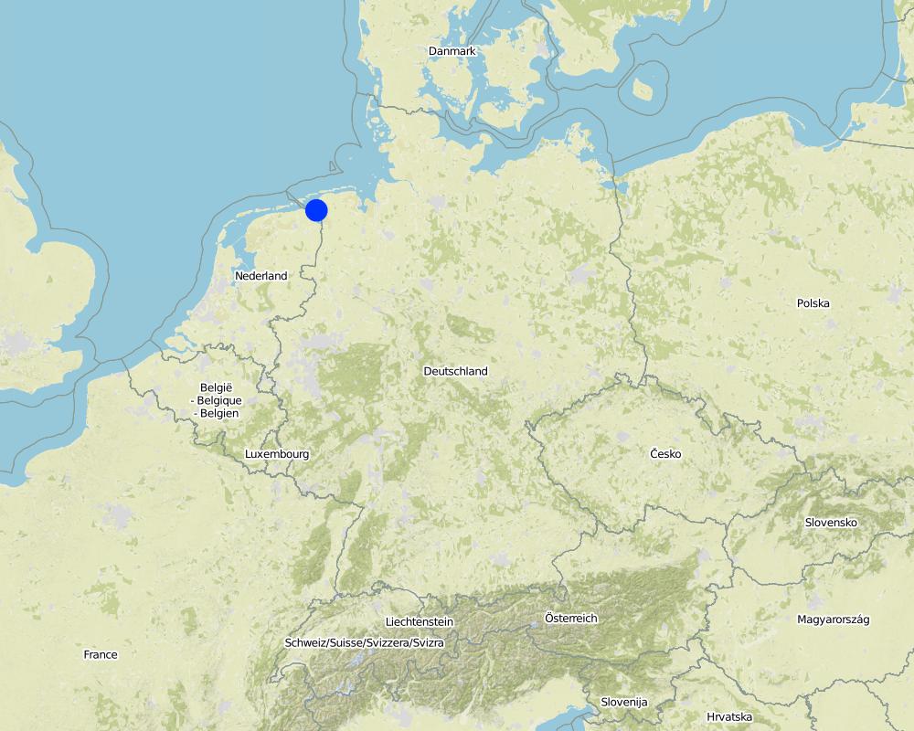
2.5 Pays/ région/ lieux où la Technologie a été appliquée et qui sont couverts par cette évaluation
Pays:
Allemagne
Région/ Etat/ Province:
Germany, Lower Saxony
Autres spécifications du lieu:
Landkreis Aurich
Commentaires:
Total area covered by the SLM Technology is 33.7 km2.
Map
×2.6 Date de mise en œuvre de la Technologie
Si l'année précise est inconnue, indiquez la date approximative: :
- il y a entre 10-50 ans
2.7 Introduction de la Technologie
Spécifiez comment la Technologie a été introduite: :
- au cours d'expérimentations / de recherches
- par le biais de projets/ d'interventions extérieures
3. Classification de la Technologie de GDT
3.2 Type(s) actuel(s) d'utilisation des terres, là où la Technologie est appliquée
Les divers types d'utilisation des terres au sein du même unité de terrain: :
Oui
Précisez l'utilisation mixte des terres (cultures/ pâturages/ arbres):
- Agropastoralisme (y compris les systèmes culture-élevage intégrés)

Terres cultivées

Pâturages
Pâturage intensif/ production fourragère :
- Affouragement en vert/ zéro-pâturage
- Prairies améliorées
Type d'animal:
- bétail - laitier
- bétail - bovins à viande
Produits et services:
- viande
- lait
Commentaires:
Major land use problems (compiler’s opinion): Flood events and droughts may substantially disrupt the contemporary land use in the future and lead to higher drainage costs and higher economic risks for agricultural production. This may reduce the ecological and economic viability of the current intensive and highly productive land use under a changing climate.
Major land use problems (land users’ perception): There is no awareness of risks due to climate change in the land users point of view.
Cut-and-carry/ zero grazing: cows for milk
Improved pasture: cattle for milk and meat
Future (final) land use (after implementation of SLM Technology): Other: Oo: Other: wastelands, deserts, glaciers, swamps, recreation areas, etc
Constraints of infrastructure network (roads, railways, pipe lines, power lines): needs to be adapted to regular flooding
Constraints of recreation (landscape is used for recreation and tourism ): change in landscape due to retention area
Constraints of nature conservation area (protected sites): wetter conditions in retention area
Number of growing seasons per year: 1
Longest growing period in days: 240Longest growing period from month to month: March to October
Livestock density: > 100 LU /km2
3.3 Est-ce que l’utilisation des terres a changé en raison de la mise en œuvre de la Technologie ?
Est-ce que l’utilisation des terres a changé en raison de la mise en œuvre de la Technologie ?
- Oui (Veuillez remplir les questions ci-après au regard de l’utilisation des terres avant la mise en œuvre de la Technologie)

Voies d'eau, plans d'eau, zones humides
- Marécages, zones humides

Terres improductives
Précisez:
wastelands
Commentaires:
Mixed: Mp: Agro-pastoralism
3.4 Approvisionnement en eau
Commentaires:
Water supply: rainfed, mixed rainfed - irrigated
3.5 Groupe de GDT auquel appartient la Technologie
- gestion des eaux de surface (sources, rivières, lacs, mers)
- gestion/ protection des zones humides
- Flood prevention
3.6 Mesures de GDT constituant la Technologie

structures physiques
- S5: Barrages/retenues, micro-bassins, étangs

modes de gestion
- M1: Changement du type d’utilisation des terres
- M2: Changement du niveau de gestion / d'intensification
Commentaires:
Main measures: structural measures
Secondary measures: management measures
3.7 Principaux types de dégradation des terres traités par la Technologie

dégradation chimique des sols
- Cs: salinisation/ alcalinisation

dégradation hydrique
- Hs: changement de la quantité d’eau de surface
- Hg: changement du niveau des nappes phréatiques (eaux souterraines) et des aquifères
- Hq: baisse de la qualité des eaux souterraines
Commentaires:
Main type of degradation addressed: Hs: change in quantity of surface water
Secondary types of degradation addressed: Cs: salinisation / alkalinisation, Hg: change in groundwater / aquifer level, Hq: decline of groundwater quality
Main causes of degradation: change of seasonal rainfall (Climate change, higher rainfall in winter, lower in summer), Heavy / extreme rainfall (intensity/amounts) (Heavy rainfall in winter due to climate change expected), floods (Flooding due to heavy rainfall in winter)
Secondary causes of degradation: droughts (Droughts due to less rainfall in summer (climate change)), other natural causes (avalanches, volcanic eruptions, mud flows, highly susceptible natural resources, extreme topography, etc.) specify (Sea level rise)
3.8 Prévention, réduction de la dégradation ou réhabilitation des terres dégradées
Spécifiez l'objectif de la Technologie au regard de la dégradation des terres:
- prévenir la dégradation des terres
- réduire la dégradation des terres
Commentaires:
Main goals: prevention of land degradation
Secondary goals: mitigation / reduction of land degradation
4. Spécifications techniques, activités, intrants et coûts de mise en œuvre
4.1 Dessin technique de la Technologie
Spécifications techniques (associées au dessin technique):
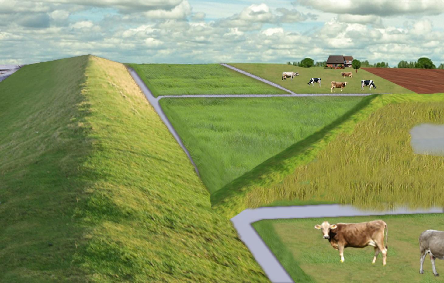
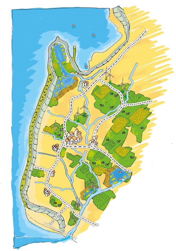
The figure shows the study region, located on the North Sea coast. The whole area is protected by a sea wall (grey). Crop fields (yellow), grasslands (green) and the drainage system (light blue) char-acterize the region. In contrast to T_GER001en and T_GER002en small water bodies (blue) surrounded by reeds (brown) act as water retention polders. Agricultural land use in some retention areas is adapted to the ground water levels and flooding frequencies. This results in parts of the retention areas being taken out of agricultural production and undisturbed development of natural habitats occurring. In other parts of the retention areas extensive grazing or reed farming will be practiced. This leads to a mosaic of different land uses in the landscape. Retention areas of 500 ha are able to store up to 2,500,000 m³ water. The height of the dams depends on the elevation of the landscape but in general a height of less than 2 m is sufficient.
Location: Krummhörn. County of Aurich, Lower Saxony
Technical knowledge required for field staff / advisors: high (To generate income in the retention area (without existing agricultural methods))
Technical knowledge required for water board: high (To build a new adapted drainage system with retention areas)
Main technical functions: control of dispersed runoff: retain / trap, control of concentrated runoff: retain / trap
Secondary technical functions: increase / maintain water stored in soil, increase of groundwater level / recharge of groundwater, spatial arrangement and diversification of land use
Dam/ pan/ pond
Height of bunds/banks/others (m): 1
Width of bunds/banks/others (m): 2
Length of bunds/banks/others (m): 13000
Construction material (earth): sand core and clay cover
Specification of dams/ pans/ ponds: Capacity 2500000m3
Catchment area: 49000ham2
Beneficial area: 49000ham2
Other specifications: size of retention area (embanked area): 500.00 ha
Change of land use type: Within the retention area the conditions are wetter than before. Therefore the agricultural land use needs to be changed to an adapted land use.
Change of land use practices / intensity level: Under the wetter conditions only a less intensive land use is possible, e.g. no crop fields but instead extensive grazing or cessation of agricultural land use.
Auteur:
Udo Schotten
4.2 Informations générales sur le calcul des intrants et des coûts
autre/ monnaie nationale (précisez):
Euro
Indiquez le taux de change des USD en devise locale, le cas échéant (p.ex. 1 USD = 79.9 réal brésilien): 1 USD = :
0,94
Indiquez le coût salarial moyen de la main d'œuvre par jour:
100.00
4.3 Activités de mise en place/ d'établissement
| Activité | Calendrier des activités (saisonnier) | |
|---|---|---|
| 1. | Building of dams | during winter months |
4.4 Coûts et intrants nécessaires à la mise en place
| Spécifiez les intrants | Unité | Quantité | Coûts par unité | Coût total par intrant | % du coût supporté par les exploitants des terres | |
|---|---|---|---|---|---|---|
| Main d'œuvre | Labour | Dam | 1,0 | 10000000,0 | 10000000,0 | |
| Equipements | Machine use | Dam | 1,0 | 4000000,0 | 4000000,0 | |
| Matériaux de construction | Earth | Dam | 1,0 | 112000,0 | 112000,0 | |
| Coût total de mise en place de la Technologie | 14112000,0 | |||||
| Coût total de mise en place de la Technologie en dollars américains (USD) | 15012765,96 | |||||
Commentaires:
Duration of establishment phase: 3 month(s)
4.5 Activités d'entretien/ récurrentes
| Activité | Calendrier/ fréquence | |
|---|---|---|
| 1. | Control of dams | once a year |
| 2. | Maintenance of dams | once a year |
| 3. | Maintenance of drainage system | once a year (mean of many years) |
4.6 Coûts et intrants nécessaires aux activités d'entretien/ récurrentes (par an)
| Spécifiez les intrants | Unité | Quantité | Coûts par unité | Coût total par intrant | % du coût supporté par les exploitants des terres | |
|---|---|---|---|---|---|---|
| Main d'œuvre | Labour | Dam | 1,0 | 500,0 | 500,0 | |
| Equipements | Machine use | Dam | 1,0 | 200,0 | 200,0 | |
| Matériaux de construction | Earth | Dam | 1,0 | 100,0 | 100,0 | |
| Autre | Maintenance per km ditch | Dam | 1,0 | 2270,7 | 2270,7 | |
| Coût total d'entretien de la Technologie | 3070,7 | |||||
| Coût total d'entretien de la Technologie en dollars américains (USD) | 3266,7 | |||||
Commentaires:
Machinery/ tools: digger, open truck
The main investment is based on a dam length of 13 km to build up the retention area of a size of 500 ha. The length of the drainage network for the whole watershed (retention area and the surroundings) is 1,134 km. Maintenance costs of drainage network are based on long term annual mean cost of 2,270.72 Euro per km including pumping costs.
4.7 Facteurs les plus importants affectant les coûts
Décrivez les facteurs les plus importants affectant les coûts :
The establishment costs are for the whole retention area (500 ha). The establishment period will be half a year.
Mainly the elevation in the region determines the costs as the height of the dams depend on the elevation. Typical heights are 1 m up to 2 m with a slope of 1:3.
5. Environnement naturel et humain
5.1 Climat
Précipitations annuelles
- < 250 mm
- 251-500 mm
- 501-750 mm
- 751-1000 mm
- 1001-1500 mm
- 1501-2000 mm
- 2001-3000 mm
- 3001-4000 mm
- > 4000 mm
Zone agro-climatique
- humide
Thermal climate class: temperate
5.2 Topographie
Pentes moyennes:
- plat (0-2 %)
- faible (3-5%)
- modéré (6-10%)
- onduleux (11-15%)
- vallonné (16-30%)
- raide (31-60%)
- très raide (>60%)
Reliefs:
- plateaux/ plaines
- crêtes
- flancs/ pentes de montagne
- flancs/ pentes de colline
- piémonts/ glacis (bas de pente)
- fonds de vallée/bas-fonds
Zones altitudinales:
- 0-100 m
- 101-500 m
- 501-1000 m
- 1001-1500 m
- 1501-2000 m
- 2001-2500 m
- 2501-3000 m
- 3001-4000 m
- > 4000 m
5.3 Sols
Profondeur moyenne du sol:
- très superficiel (0-20 cm)
- superficiel (21-50 cm)
- modérément profond (51-80 cm)
- profond (81-120 cm)
- très profond (>120 cm)
Texture du sol (de la couche arable):
- fin/ lourd (argile)
Matière organique de la couche arable:
- abondant (>3%)
Si disponible, joignez une description complète du sol ou précisez les informations disponibles, par ex., type de sol, pH/ acidité du sol, capacité d'échange cationique, azote, salinité, etc.
Soil fertility is high
Soil drainage/infiltration is meidum
Soil water storage capacity is high
5.4 Disponibilité et qualité de l'eau
Profondeur estimée de l’eau dans le sol:
< 5 m
Disponibilité de l’eau de surface:
bonne
Qualité de l’eau (non traitée):
uniquement pour usage agricole (irrigation)
5.5 Biodiversité
Diversité des espèces:
- faible
5.6 Caractéristiques des exploitants des terres appliquant la Technologie
Orientation du système de production:
- commercial/ de marché
Revenus hors exploitation:
- 10-50% de tous les revenus
Niveau relatif de richesse:
- moyen
Individus ou groupes:
- employé (entreprise, gouvernement)
Niveau de mécanisation:
- mécanisé/ motorisé
Genre:
- femmes
- hommes
Indiquez toute autre caractéristique pertinente des exploitants des terres:
Land users applying the Technology are mainly common / average land users
Population density: 50-100 persons/km2
Annual population growth: < 0.5%
1% of the land users are very rich and own 1% of the land.
49% of the land users are rich and own 24% of the land.
50% of the land users are average wealthy and own 50% of the land.
and own 25% of the land.
Off-farm income specification: Many farmers do additional work in companies
5.7 Superficie moyenne des terres utilisées par les exploitants des terres appliquant la Technologie
- < 0,5 ha
- 0,5-1 ha
- 1-2 ha
- 2-5 ha
- 5-15 ha
- 15-50 ha
- 50-100 ha
- 100-500 ha
- 500-1 000 ha
- 1 000-10 000 ha
- > 10 000 ha
Cette superficie est-elle considérée comme de petite, moyenne ou grande dimension (en se référant au contexte local)?
- grande dimension
Commentaires:
Average area of land owned or leased by land users applying the Technology: 5-15 ha, 15-50 ha, 50-100 ha, 100-500 ha
5.8 Propriété foncière, droits d’utilisation des terres et de l'eau
Propriété foncière:
- individu, sans titre de propriété
Droits d’utilisation des terres:
- individuel
5.9 Accès aux services et aux infrastructures
santé:
- pauvre
- modéré
- bonne
éducation:
- pauvre
- modéré
- bonne
assistance technique:
- pauvre
- modéré
- bonne
emploi (par ex. hors exploitation):
- pauvre
- modéré
- bonne
marchés:
- pauvre
- modéré
- bonne
énergie:
- pauvre
- modéré
- bonne
routes et transports:
- pauvre
- modéré
- bonne
eau potable et assainissement:
- pauvre
- modéré
- bonne
services financiers:
- pauvre
- modéré
- bonne
6. Impacts et conclusions
6.1 Impacts sur site que la Technologie a montrés
Impacts socio-économiques
Production
production agricole
Commentaires/ spécifiez:
Under wet conditions in the retention area a crop production is not possible any more.
production fourragère
Commentaires/ spécifiez:
Under wet conditions in the retention area an intensive fodder production is not possible any more.
qualité des fourrages
Commentaires/ spécifiez:
Under wet conditions in the retention area the optiomal fodder quality can not ensured any more.
risque d'échec de la production
Commentaires/ spécifiez:
Regarding crops: The retention area is used for excess water and may be flooded during growing season.
Revenus et coûts
dépenses pour les intrants agricoles
Commentaires/ spécifiez:
Only adjusted land use takes place, therefore the expenses are reduced nearly to 0.
revenus agricoles
diversité des sources de revenus
Commentaires/ spécifiez:
Due to land use adapted to the conditions the typical land use is not possible and a diversitfication will take place with reed mowing and extensive grazing in the retention area.
Autres impacts socio-économiques
Intrusion by saline groundwater
Impacts socioculturels
possibilités de loisirs
Commentaires/ spécifiez:
Diversification of landscape by building the retention area will increase the attractivity for recreation and tourists.
connaissances sur la GDT/ dégradation des terres
Commentaires/ spécifiez:
Less intensive land use results in more diversity and conservation of regional species and habitats.
apaisement des conflits
Improved livelihoods and human well-being
Commentaires/ spécifiez:
'Regional belonging' and 'feeling of safety' are measured. The amount of increase is modelled and will be added here.
Impacts écologiques
Cycle de l'eau/ ruissellement
quantité d'eau
Commentaires/ spécifiez:
Typical for the region are wet situations. These typical wet conditions are restored by cessation of drainage system within the retention area.
qualité de l'eau
Commentaires/ spécifiez:
Updwelling of saline groundwater is prevented by increased water level in the retention area.
nappes phréatiques/ aquifères
Commentaires/ spécifiez:
By water in the retention are the recharge of groundwater will increase and prevent salinization.
évaporation
Commentaires/ spécifiez:
Instead of pumping water into the sea a higher amount is evapotranspirated naturally.
Sols
humidité du sol
Commentaires/ spécifiez:
Typical for the region are wet situations. These typical wet conditions are restored by cessation of drainage system within the retention area.
salinité
Commentaires/ spécifiez:
By water in the retention are the recharge of groundwater will increase and prevent salinization.
matière organique du sol/ au dessous du sol C
Commentaires/ spécifiez:
By wetter conditions the soil organic matter will be increased.
Biodiversité: végétale, animale
diversité végétale
Commentaires/ spécifiez:
By diversification of land use the number of species will be increased, especially due to extensive land use.
diversité animale
Commentaires/ spécifiez:
By diversification of land use the number of species will be increased, especially due to extensive land use.
diversité des habitats
Commentaires/ spécifiez:
By diversification of land use the number of habitats will be increased.
Réduction des risques de catastrophe et des risques climatiques
émissions de carbone et de gaz à effet de serre
Commentaires/ spécifiez:
Modelled is the global warming potential by gas emissions. Not yet clear if it is benefit or disadvantage. Model will show.
6.2 Impacts hors site que la Technologie a montrés
disponibilité de l'eau
flux des cours d'eau fiables et stables en saison sèche
Commentaires/ spécifiez:
Water stored in retention area can be used for irrigation during dry summer months.
inondations en aval
Commentaires/ spécifiez:
Measured m3 of excess water in the catchment area, leading to floods or needs to be pumped. Exact values from modelling will be added as soon as possible!
dommages sur les champs voisins
dommages sur les infrastructures publiques/ privées
Reduced hazard towards adverse events
6.3 Exposition et sensibilité de la Technologie aux changements progressifs et aux évènements extrêmes/catastrophes liés au climat (telles que perçues par les exploitants des terres)
Changements climatiques progressifs
Changements climatiques progressifs
| Saison | Augmentation ou diminution | Comment la Technologie fait-elle face à cela? | |
|---|---|---|---|
| températures annuelles | augmente | bien |
Extrêmes climatiques (catastrophes)
Catastrophes météorologiques
| Comment la Technologie fait-elle face à cela? | |
|---|---|
| pluie torrentielle locale | bien |
| tempête de vent locale | bien |
Catastrophes climatiques
| Comment la Technologie fait-elle face à cela? | |
|---|---|
| sécheresse | bien |
Catastrophes hydrologiques
| Comment la Technologie fait-elle face à cela? | |
|---|---|
| inondation générale (rivière) | bien |
Autres conséquences liées au climat
Autres conséquences liées au climat
| Comment la Technologie fait-elle face à cela? | |
|---|---|
| réduction de la période de croissance | pas connu |
6.4 Analyse coûts-bénéfices
Quels sont les bénéfices comparativement aux coûts de mise en place (du point de vue des exploitants des terres)?
Rentabilité à court terme:
négative
Rentabilité à long terme:
légèrement positive
Quels sont les bénéfices comparativement aux coûts d'entretien récurrents (du point de vue des exploitants des terres)?
Rentabilité à court terme:
légèrement positive
Rentabilité à long terme:
très positive
Commentaires:
The benefits will be visible in an longer time frame. There will be benefits of the investments when considering sea level rise in the upcoming 100 years.
6.5 Adoption de la Technologie
Commentaires:
Comments on spontaneous adoption: The SLM Technology is not implemented by land users but needs to be implemented in spatial planning of the federal state. We expect that there is a chance for implementation.
There is a strong trend towards spontaneous adoption of the Technology
Comments on adoption trend: The SLM Technology was developed together with regional experts. It seems that the ideas developed, merge more often in their recent discussion and an implementation is likely.
6.7 Points forts/ avantages/ possibilités de la Technologie
| Points forts/ avantages/ possibilités du point de vue de l'exploitant des terres |
|---|
|
The retention area will supplement the drainage of the arable fields and pastures outside the retention area How can they be sustained / enhanced? Combine with other technical solutions for protection against flooding. |
| Points forts/ avantages/ possibilités du point de vue du compilateur ou d'une autre personne ressource clé |
|---|
|
Prevention of flooding during strong rainfalls and possibility to irrigate during dry periods How can they be sustained / enhanced? The larger the retention areas are the more water can be stored |
|
Prevention of salt water intrusion in the region How can they be sustained / enhanced? Fresh water in the retention areas prevents saline ground water from intrusion. Build polders in areas where saline ground water intrudes. |
|
Endangered species might obtain new habitats in the retention area How can they be sustained / enhanced? Extensive land use can help to optimize the habitats for endan-gered species and increase attractiveness for tourism. |
|
Through investments in building retention polders the very ex-pensive strengthening of the existing drainage system is no longer necessary. How can they be sustained / enhanced? By increasing the attractiveness for tourism alternative benefits for land owner can be generated. |
|
Multi-functional land use in the catchment and in the retention area How can they be sustained / enhanced? Support farmers with land in the retention area (e.g. financially or with additional agricultural land outside the retention area). Sup-port discussions between farmers’ associations and nature con-servation agencies. |
6.8 Faiblesses/ inconvénients/ risques de la Technologie et moyens de les surmonter
| Faiblesses/ inconvénients/ risques du point de vue de l’exploitant des terres | Comment peuvent-ils être surmontés? |
|---|---|
| The retention polders will change the landscape and this may reduce the value of the region for tourism | Include tourist concerns within the retention area (accessibility, information, attractiveness) |
| Endangered species might lose habitats when building up the retention polders | Do not build a retention area where endangered species live |
| Loss of livelihoods | Retention areas should be planned for parts of the landscape without settlements |
| Faiblesses/ inconvénients/ risques du point de vue du compilateur ou d'une autre personne ressource clé | Comment peuvent-ils être surmontés? |
|---|---|
| Loss of land for agricultural production | Create retention polders where the productivity is already low. Encourage alternative land use (for example reed production) in the retention polders. |
| High water levels (especially with changing levels) may generate high emissions of greenhouse gases. | Ground water levels should kept stable near to the soil surface. |
| Retention area is probably too small if pessimistic sea level rise predictions come true. | Increase size of retention polders. |
7. Références et liens
7.1 Méthodes/ sources d'information
7.2 Références des publications disponibles
Titre, auteur, année, ISBN:
http://www.comtess.uni-oldenburg.de/
7.3 Liens vers les informations pertinentes en ligne
Titre/ description:
http://www.comtess.uni-oldenburg.de/
Liens et modules
Développer tout Réduire toutLiens
Stakeholder participation in integrated assessment and planning of … [Allemagne]
Stakeholders have been involved in integrated assessment to develop action-oriented land use options addressing possible climate change adaptation measures as alternatives to traditional coastal protection strategies.
- Compilateur : Martin Maier
Modules
Aucun module trouvé