Water retention polders to improve water management [Alemanha]
- Criação:
- Atualização:
- Compilador/a: Martin Maier
- Editor: –
- Revisores: Fabian Ottiger, David Streiff, Alexandra Gavilano
Polder zum Wassermanagement entwickelt durch lokale Experten (Nordsee Region)
technologies_1583 - Alemanha
Veja as seções
Expandir tudo Recolher tudo1. Informação geral
1.2 Detalhes do contato das pessoas capacitadas e instituições envolvidas na avaliação e documentação da tecnologia
Pessoa(s) capacitada(s)
Especialista em GST:
Kleyer Michael
University of Oldenburg
Alemanha
Especialista em GST:
Karrasch Leena
University of Oldenburg
Alemanha
Especialista em GST:
Mayer Martin
University of Oldenburg
Alemanha
Nome do projeto que facilitou a documentação/avaliação da Tecnologia (se relevante)
Book project: Making sense of research for sustainable land management (GLUES)Nome do projeto que facilitou a documentação/avaliação da Tecnologia (se relevante)
Sustainable Coastal Land Management (COMTESS / GLUES)Nome da(s) instituição(ões) que facilitou(ram) a documentação/ avaliação da Tecnologia (se relevante)
University of Oldenburg (University of Oldenburg) - Alemanha1.3 Condições em relação ao uso da informação documentada através de WOCAT
O compilador e a(s) pessoa(s) capacitada(s) aceitam as condições relativas ao uso de dados documentados através do WOCAT:
Sim
1.5 Referência ao(s) questionário(s) sobre abordagens GST (documentado(s) usando WOCAT)
Stakeholder participation in integrated assessment and planning of … [Alemanha]
Stakeholders have been involved in integrated assessment to develop action-oriented land use options addressing possible climate change adaptation measures as alternatives to traditional coastal protection strategies.
- Compilador/a: Martin Maier
2. Descrição da tecnologia de GST
2.1 Descrição curta da tecnologia
Definição da tecnologia:
Water retaining polders to reduce flood risk due to heavy rainfall or runoff at high tide in embanked coastal lowlands. Delineation of the retention area and land use within the retention area was developed in a participatory process with local experts.
2.2 Descrição detalhada da tecnologia
Descrição:
In the 19th and 20th century land was reclaimed from the sea to make use of the exposed fertile soils for agriculture through a process known as ‘impoldering’. The reclaimed land is now characterized by intensive grazing and cropland. This is a region where agriculture is the most important form of land use. However, the land needs to be regularly drained. Given the expected increase in precipitation in winter due to climate change, the corresponding increase in freshwater discharge needs to be managed. Furthermore, the periods when natural discharge into the sea oc-curs are likely to decrease – because of rising sea levels also caused by climate change. Consequently, in winter and spring, greater quantities of freshwater will need to be pumped into the sea rather than discharged naturally at the low or ‘ebb’ tide. Specially embanked water retention polders will be required to temporarily impound water as part of a multifunctional approach to coastal zone management.
Purpose of the Technology: These retention polders could be a cost-effective alternative to expensive invest-ments in extra pumping capacities to prevent submergence of low-lying cultivated areas. The primary aim is to restrict floods to the retention polders when the drain-age network is overburdened and cannot deal with the predicted extra demands in the future. The high evapotranspiration from the open waterbody, and the reeds growing within, will also help with reducing the amount of water. During dry sum-mers, the water in the retention polder could also be put to creative use as a source of irrigation. Another potential advantage is that subsurface saltwater intrusion in the region could be prevented by the freshwater-filled polders. During extreme storm surges and in the rare case of breaches in the sea wall, the retention polders would serve as an extra line of defence by holding seawater.
Establishment / maintenance activities and inputs: An embankment enclosing approx. 500 ha will be able to store up to 2,500,000 m³ of water. This will improve the drainage of an area of approx. 49,000 ha. The invest-ment for building this water retention area is high – but for the reasons stated it serves a necessary purpose at a cost which is lower than the alternative – increased pumped drainage installations. Maintenance costs will be lower than the drainage alternative as only the integrity of the embankment needs to be monitored regularly. Currently, agricultural land use within the polders is adapted to higher water levels and occasional flooding. Within the embanked area there will be a change from the current use of mainly crop land to extensive grazing, open water and reed stands.
Natural / human environment: Some parts within the retention polder will be used for agricultural purposes, while the wetter parts will be set aside. In these latter sections, undisturbed natural regen-eration will take place. A landscape comprising various different elements, without any extreme forms of intensive land use such as large areas of monocultures will be the result. Thus requirements for agricultural use and tourism will be addressed.
2.3 Fotos da tecnologia
Galeria de Mídias
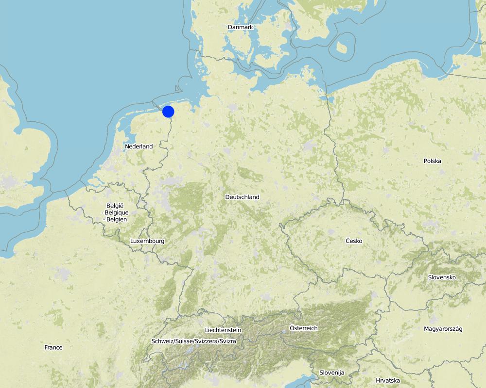
2.5 País/região/locais onde a tecnologia foi aplicada e que estão cobertos nesta avaliação
País:
Alemanha
Região/Estado/Província:
Germany, Lower Saxony
Especificação adicional de localização:
Landkreis Aurich
Comentários:
Total area covered by the SLM Technology is 33.7 km2.
Map
×2.6 Data da implementação
Caso o ano exato seja desconhecido, indique a data aproximada:
- 10-50 anos atrás
2.7 Introdução da tecnologia
Especifique como a tecnologia foi introduzida:
- durante experiências/ pesquisa
- através de projetos/intervenções externas
3. Classificação da tecnologia de GST
3.2 Tipo(s) atualizado(s) de uso da terra onde a tecnologia foi aplicada
Uso do solo misturado dentro da mesma unidade de terra:
Sim
Especificar o uso misto da terra (culturas/ pastoreio/ árvores):
- Agropecuária (incl. agricultura e pecuária)

Terra de cultivo

Pastagem
Pastagem intensiva/produção de forragem:
- Semiestabulação/sem pastagem
- Pastos melhorados
Tipo de animal:
- gado - lácteo
- gado - carne bovina não-láctea
Produtos e serviços:
- carne
- leite
Comentários:
Major land use problems (compiler’s opinion): Flood events and droughts may substantially disrupt the contemporary land use in the future and lead to higher drainage costs and higher economic risks for agricultural production. This may reduce the ecological and economic viability of the current intensive and highly productive land use under a changing climate.
Major land use problems (land users’ perception): There is no awareness of risks due to climate change in the land users point of view.
Cut-and-carry/ zero grazing: cows for milk
Improved pasture: cattle for milk and meat
Future (final) land use (after implementation of SLM Technology): Other: Oo: Other: wastelands, deserts, glaciers, swamps, recreation areas, etc
Constraints of infrastructure network (roads, railways, pipe lines, power lines): needs to be adapted to regular flooding
Constraints of recreation (landscape is used for recreation and tourism ): change in landscape due to retention area
Constraints of nature conservation area (protected sites): wetter conditions in retention area
Number of growing seasons per year: 1
Longest growing period in days: 240Longest growing period from month to month: March to October
Livestock density: > 100 LU /km2
3.3 O uso do solo mudou devido à implementação da Tecnologia?
O uso do solo mudou devido à implementação da Tecnologia?
- Sim (Por favor, preencha as perguntas abaixo com relação ao uso do solo antes da implementação da Tecnologia)

Vias navegáveis, corpo d'água, zonas úmidas
- Pântanos, zonas úmidas

Terra improdutiva
Especifique:
wastelands
Comentários:
Mixed: Mp: Agro-pastoralism
3.4 Abastecimento de água
Comentários:
Water supply: rainfed, mixed rainfed - irrigated
3.5 Grupo de GST ao qual pertence a tecnologia
- Gestão de água de superfície (nascente, rio, lagos, mar)
- Gestão/proteção de zonas úmidas
- Flood prevention
3.6 Medidas de GST contendo a tecnologia

Medidas estruturais
- S5: Represa, bacia, lago

Medidas de gestão
- M1: Mudança no tipo de uso da terra
- M2: Mudança de gestão/nível de intensidade
Comentários:
Main measures: structural measures
Secondary measures: management measures
3.7 Principais tipos de degradação da terra abordados pela tecnologia

Deteriorização química do solo
- Cs: salinização/alcalinização

Degradação da água
- Hs: mudança na quantidade de água de superfície
- Hg: mudança no lençol freático/aquífero
- Hq: declínio da qualidade do lençol freático
Comentários:
Main type of degradation addressed: Hs: change in quantity of surface water
Secondary types of degradation addressed: Cs: salinisation / alkalinisation, Hg: change in groundwater / aquifer level, Hq: decline of groundwater quality
Main causes of degradation: change of seasonal rainfall (Climate change, higher rainfall in winter, lower in summer), Heavy / extreme rainfall (intensity/amounts) (Heavy rainfall in winter due to climate change expected), floods (Flooding due to heavy rainfall in winter)
Secondary causes of degradation: droughts (Droughts due to less rainfall in summer (climate change)), other natural causes (avalanches, volcanic eruptions, mud flows, highly susceptible natural resources, extreme topography, etc.) specify (Sea level rise)
3.8 Redução, prevenção ou recuperação da degradação do solo
Especifique o objetivo da tecnologia em relação a degradação da terra:
- Prevenir degradação do solo
- Reduzir a degradação do solo
Comentários:
Main goals: prevention of land degradation
Secondary goals: mitigation / reduction of land degradation
4. Especificações técnicas, implementação de atividades, entradas e custos
4.1 Desenho técnico da tecnologia
Especificações técnicas (relacionada ao desenho técnico):
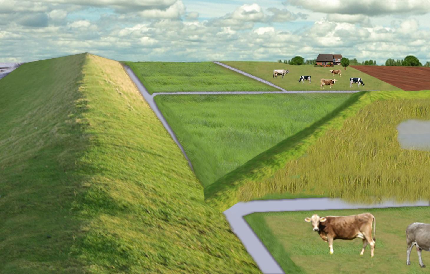
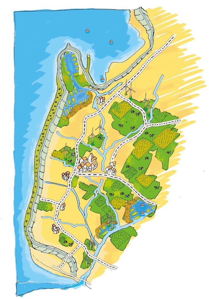
The figure shows the study region, located on the North Sea coast. The whole area is protected by a sea wall (grey). Crop fields (yellow), grasslands (green) and the drainage system (light blue) char-acterize the region. In contrast to T_GER001en and T_GER002en small water bodies (blue) surrounded by reeds (brown) act as water retention polders. Agricultural land use in some retention areas is adapted to the ground water levels and flooding frequencies. This results in parts of the retention areas being taken out of agricultural production and undisturbed development of natural habitats occurring. In other parts of the retention areas extensive grazing or reed farming will be practiced. This leads to a mosaic of different land uses in the landscape. Retention areas of 500 ha are able to store up to 2,500,000 m³ water. The height of the dams depends on the elevation of the landscape but in general a height of less than 2 m is sufficient.
Location: Krummhörn. County of Aurich, Lower Saxony
Technical knowledge required for field staff / advisors: high (To generate income in the retention area (without existing agricultural methods))
Technical knowledge required for water board: high (To build a new adapted drainage system with retention areas)
Main technical functions: control of dispersed runoff: retain / trap, control of concentrated runoff: retain / trap
Secondary technical functions: increase / maintain water stored in soil, increase of groundwater level / recharge of groundwater, spatial arrangement and diversification of land use
Dam/ pan/ pond
Height of bunds/banks/others (m): 1
Width of bunds/banks/others (m): 2
Length of bunds/banks/others (m): 13000
Construction material (earth): sand core and clay cover
Specification of dams/ pans/ ponds: Capacity 2500000m3
Catchment area: 49000ham2
Beneficial area: 49000ham2
Other specifications: size of retention area (embanked area): 500.00 ha
Change of land use type: Within the retention area the conditions are wetter than before. Therefore the agricultural land use needs to be changed to an adapted land use.
Change of land use practices / intensity level: Under the wetter conditions only a less intensive land use is possible, e.g. no crop fields but instead extensive grazing or cessation of agricultural land use.
Autor:
Udo Schotten
4.2 Informação geral em relação ao cálculo de entradas e custos
Outro/moeda nacional (especifique):
Euro
Se for relevante, indique a taxa de câmbio do USD para moeda local (por exemplo, 1 USD = 79,9 Real): 1 USD =:
0,94
Indique a média salarial da mão-de-obra contratada por dia:
100.00
4.3 Atividades de implantação
| Atividade | Periodicidade (estação do ano) | |
|---|---|---|
| 1. | Building of dams | during winter months |
4.4 Custos e entradas necessárias para a implantação
| Especifique a entrada | Unidade | Quantidade | Custos por unidade | Custos totais por entrada | % dos custos arcados pelos usuários da terra | |
|---|---|---|---|---|---|---|
| Mão-de-obra | Labour | Dam | 1,0 | 10000000,0 | 10000000,0 | |
| Equipamento | Machine use | Dam | 1,0 | 4000000,0 | 4000000,0 | |
| Material de construção | Earth | Dam | 1,0 | 112000,0 | 112000,0 | |
| Custos totais para a implantação da tecnologia | 14112000,0 | |||||
| Custos totais para o estabelecimento da Tecnologia em USD | 15012765,96 | |||||
Comentários:
Duration of establishment phase: 3 month(s)
4.5 Atividades recorrentes/manutenção
| Atividade | Periodicidade/frequência | |
|---|---|---|
| 1. | Control of dams | once a year |
| 2. | Maintenance of dams | once a year |
| 3. | Maintenance of drainage system | once a year (mean of many years) |
4.6 Custos e entradas necessárias pata a manutenção/atividades recorrentes (por ano)
| Especifique a entrada | Unidade | Quantidade | Custos por unidade | Custos totais por entrada | % dos custos arcados pelos usuários da terra | |
|---|---|---|---|---|---|---|
| Mão-de-obra | Labour | Dam | 1,0 | 500,0 | 500,0 | |
| Equipamento | Machine use | Dam | 1,0 | 200,0 | 200,0 | |
| Material de construção | Earth | Dam | 1,0 | 100,0 | 100,0 | |
| Outros | Maintenance per km ditch | Dam | 1,0 | 2270,7 | 2270,7 | |
| Custos totais para a manutenção da tecnologia | 3070,7 | |||||
| Custos totais de manutenção da Tecnologia em USD | 3266,7 | |||||
Comentários:
Machinery/ tools: digger, open truck
The main investment is based on a dam length of 13 km to build up the retention area of a size of 500 ha. The length of the drainage network for the whole watershed (retention area and the surroundings) is 1,134 km. Maintenance costs of drainage network are based on long term annual mean cost of 2,270.72 Euro per km including pumping costs.
4.7 Fatores mais importantes que afetam os custos
Descreva os fatores mais determinantes que afetam os custos:
The establishment costs are for the whole retention area (500 ha). The establishment period will be half a year.
Mainly the elevation in the region determines the costs as the height of the dams depend on the elevation. Typical heights are 1 m up to 2 m with a slope of 1:3.
5. Ambiente natural e humano
5.1 Clima
Precipitação pluviométrica anual
- <250 mm
- 251-500 mm
- 501-750 mm
- 751-1.000 mm
- 1.001-1.500 mm
- 1.501-2.000 mm
- 2.001-3.000 mm
- 3.001-4.000 mm
- > 4.000 mm
Zona agroclimática
- úmido
Thermal climate class: temperate
5.2 Topografia
Declividade média:
- Plano (0-2%)
- Suave ondulado (3-5%)
- Ondulado (6-10%)
- Moderadamente ondulado (11-15%)
- Forte ondulado (16-30%)
- Montanhoso (31-60%)
- Escarpado (>60%)
Formas de relevo:
- Planalto/planície
- Cumes
- Encosta de serra
- Encosta de morro
- Sopés
- Fundos de vale
Zona de altitude:
- 0-100 m s.n.m.
- 101-500 m s.n.m.
- 501-1.000 m s.n.m.
- 1.001-1.500 m s.n.m.
- 1.501-2.000 m s.n.m.
- 2.001-2.500 m s.n.m.
- 2.501-3.000 m s.n.m.
- 3.001-4.000 m s.n.m.
- > 4.000 m s.n.m.
5.3 Solos
Profundidade do solo em média:
- Muito raso (0-20 cm)
- Raso (21-50 cm)
- Moderadamente profundo (51-80 cm)
- Profundo (81-120 cm)
- Muito profundo (>120 cm)
Textura do solo (solo superficial):
- Fino/pesado (argila)
Matéria orgânica do solo superficial:
- Alto (>3%)
Caso disponível anexe a descrição completa do solo ou especifique as informações disponíveis, p. ex. tipo de solo, PH/acidez do solo, nitrogênio, capacidade de troca catiônica, salinidade, etc.
Soil fertility is high
Soil drainage/infiltration is meidum
Soil water storage capacity is high
5.4 Disponibilidade e qualidade de água
Lençol freático:
< 5 m
Disponibilidade de água de superfície:
Bom
Qualidade da água (não tratada):
apenas para uso agrícola (irrigação)
5.5 Biodiversidade
Diversidade de espécies:
- Baixo
5.6 Características dos usuários da terra que utilizam a tecnologia
Orientação de mercado do sistema de produção:
- Comercial/mercado
Rendimento não agrícola:
- 10-50% de toda renda
Nível relativo de riqueza:
- Média
Indivíduos ou grupos:
- Empregado (empresa, governo)
Nível de mecanização:
- Mecanizado/motorizado
Gênero:
- Mulheres
- Homens
Indique outras características relevantes dos usuários da terra:
Land users applying the Technology are mainly common / average land users
Population density: 50-100 persons/km2
Annual population growth: < 0.5%
1% of the land users are very rich and own 1% of the land.
49% of the land users are rich and own 24% of the land.
50% of the land users are average wealthy and own 50% of the land.
and own 25% of the land.
Off-farm income specification: Many farmers do additional work in companies
5.7 Área média de terrenos utilizados pelos usuários de terrenos que aplicam a Tecnologia
- < 0,5 ha
- 0,5-1 ha
- 1-2 ha
- 2-5 ha
- 5-15 ha
- 15-50 ha
- 50-100 ha
- 100-500 ha
- 500-1.000 ha
- 1.000-10.000 ha
- > 10.000 ha
É considerado pequena, média ou grande escala (referente ao contexto local)?
- Grande escala
Comentários:
Average area of land owned or leased by land users applying the Technology: 5-15 ha, 15-50 ha, 50-100 ha, 100-500 ha
5.8 Propriedade de terra, direitos de uso da terra e de uso da água
Propriedade da terra:
- Indivíduo, não intitulado
Direitos do uso da terra:
- Indivíduo
5.9 Acesso a serviços e infraestrutura
Saúde:
- Pobre
- Moderado
- Bom
Educação:
- Pobre
- Moderado
- Bom
Assistência técnica:
- Pobre
- Moderado
- Bom
Emprego (p. ex. não agrícola):
- Pobre
- Moderado
- Bom
Mercados:
- Pobre
- Moderado
- Bom
Energia:
- Pobre
- Moderado
- Bom
Vias e transporte:
- Pobre
- Moderado
- Bom
Água potável e saneamento:
- Pobre
- Moderado
- Bom
Serviços financeiros:
- Pobre
- Moderado
- Bom
6. Impactos e declarações finais
6.1 Impactos no local mostrados pela tecnologia
Impactos socioeconômicos
Produção
Produção agrícola
Comentários/especificar:
Under wet conditions in the retention area a crop production is not possible any more.
Produção de forragens
Comentários/especificar:
Under wet conditions in the retention area an intensive fodder production is not possible any more.
Qualidade da forragem
Comentários/especificar:
Under wet conditions in the retention area the optiomal fodder quality can not ensured any more.
Risco de falha de produção
Comentários/especificar:
Regarding crops: The retention area is used for excess water and may be flooded during growing season.
Renda e custos
Despesas com insumos agrícolas
Comentários/especificar:
Only adjusted land use takes place, therefore the expenses are reduced nearly to 0.
Rendimento agrícola
Diversidade de fontes de rendimento
Comentários/especificar:
Due to land use adapted to the conditions the typical land use is not possible and a diversitfication will take place with reed mowing and extensive grazing in the retention area.
Outros impactos socioeconômicos
Intrusion by saline groundwater
Impactos socioculturais
Oportunidades de lazer
Comentários/especificar:
Diversification of landscape by building the retention area will increase the attractivity for recreation and tourists.
Conhecimento de GST/ degradação da terra
Comentários/especificar:
Less intensive land use results in more diversity and conservation of regional species and habitats.
Atenuação de conflitos
Improved livelihoods and human well-being
Comentários/especificar:
'Regional belonging' and 'feeling of safety' are measured. The amount of increase is modelled and will be added here.
Impactos ecológicos
Ciclo hídrico/escoamento
Quantidade de água
Comentários/especificar:
Typical for the region are wet situations. These typical wet conditions are restored by cessation of drainage system within the retention area.
Qualidade de água
Comentários/especificar:
Updwelling of saline groundwater is prevented by increased water level in the retention area.
Lençol freático/aquífero
Comentários/especificar:
By water in the retention are the recharge of groundwater will increase and prevent salinization.
Evaporação
Comentários/especificar:
Instead of pumping water into the sea a higher amount is evapotranspirated naturally.
Solo
Umidade do solo
Comentários/especificar:
Typical for the region are wet situations. These typical wet conditions are restored by cessation of drainage system within the retention area.
Salinidade
Comentários/especificar:
By water in the retention are the recharge of groundwater will increase and prevent salinization.
Matéria orgânica do solo/carbono abaixo do solo
Comentários/especificar:
By wetter conditions the soil organic matter will be increased.
Biodiversidade: vegetação, animais
Diversidade vegetal
Comentários/especificar:
By diversification of land use the number of species will be increased, especially due to extensive land use.
Diversidade animal
Comentários/especificar:
By diversification of land use the number of species will be increased, especially due to extensive land use.
Diversidade de habitat
Comentários/especificar:
By diversification of land use the number of habitats will be increased.
Clima e redução de riscos de desastre
Emissão de carbono e gases de efeito estufa
Comentários/especificar:
Modelled is the global warming potential by gas emissions. Not yet clear if it is benefit or disadvantage. Model will show.
6.2 Impactos externos mostrados pela tecnologia
Disponibilidade de água
Caudal confiável e estável em período seco
Comentários/especificar:
Water stored in retention area can be used for irrigation during dry summer months.
Cheias de jusante
Comentários/especificar:
Measured m3 of excess water in the catchment area, leading to floods or needs to be pumped. Exact values from modelling will be added as soon as possible!
Danos em áreas vizinhas
Danos na infraestrutura pública/privada
Reduced hazard towards adverse events
6.3 Exposição e sensibilidade da tecnologia às mudanças climáticas graduais e extremos/desastres relacionados ao clima (conforme o ponto de vista dos usuários da terra)
Mudança climática gradual
Mudança climática gradual
| Estação do ano | aumento ou diminuição | Como a tecnologia lida com isso? | |
|---|---|---|---|
| Temperatura anual | aumento | bem |
Extremos (desastres) relacionados ao clima
Desastres meteorológicos
| Como a tecnologia lida com isso? | |
|---|---|
| Temporal local | bem |
| Tempestade de vento local | bem |
Desastres climatológicos
| Como a tecnologia lida com isso? | |
|---|---|
| Seca | bem |
Desastres hidrológicos
| Como a tecnologia lida com isso? | |
|---|---|
| Inundação geral (rio) | bem |
Outras consequências relacionadas ao clima
Outras consequências relacionadas ao clima
| Como a tecnologia lida com isso? | |
|---|---|
| Período de crescimento reduzido | não conhecido |
6.4 Análise do custo-benefício
Como os benefícios se comparam aos custos de implantação (do ponto de vista dos usuários da terra)?
Retornos a curto prazo:
negativo
Retornos a longo prazo:
levemente positivo
Como os benefícios se comparam aos custos recorrentes/de manutenção(do ponto de vista dos usuários da terra)?
Retornos a curto prazo:
levemente positivo
Retornos a longo prazo:
muito positivo
Comentários:
The benefits will be visible in an longer time frame. There will be benefits of the investments when considering sea level rise in the upcoming 100 years.
6.5 Adoção da tecnologia
Comentários:
Comments on spontaneous adoption: The SLM Technology is not implemented by land users but needs to be implemented in spatial planning of the federal state. We expect that there is a chance for implementation.
There is a strong trend towards spontaneous adoption of the Technology
Comments on adoption trend: The SLM Technology was developed together with regional experts. It seems that the ideas developed, merge more often in their recent discussion and an implementation is likely.
6.7 Pontos fortes/vantagens/oportunidades da tecnologia
| Pontos fortes/vantagens/oportunidades na visão do usuário da terra |
|---|
|
The retention area will supplement the drainage of the arable fields and pastures outside the retention area How can they be sustained / enhanced? Combine with other technical solutions for protection against flooding. |
| Pontos fortes/vantagens/oportunidades na visão do compilador ou de outra pessoa capacitada |
|---|
|
Prevention of flooding during strong rainfalls and possibility to irrigate during dry periods How can they be sustained / enhanced? The larger the retention areas are the more water can be stored |
|
Prevention of salt water intrusion in the region How can they be sustained / enhanced? Fresh water in the retention areas prevents saline ground water from intrusion. Build polders in areas where saline ground water intrudes. |
|
Endangered species might obtain new habitats in the retention area How can they be sustained / enhanced? Extensive land use can help to optimize the habitats for endan-gered species and increase attractiveness for tourism. |
|
Through investments in building retention polders the very ex-pensive strengthening of the existing drainage system is no longer necessary. How can they be sustained / enhanced? By increasing the attractiveness for tourism alternative benefits for land owner can be generated. |
|
Multi-functional land use in the catchment and in the retention area How can they be sustained / enhanced? Support farmers with land in the retention area (e.g. financially or with additional agricultural land outside the retention area). Sup-port discussions between farmers’ associations and nature con-servation agencies. |
6.8 Pontos fracos, desvantagens/riscos da tecnologia e formas de superá-los
| Pontos fracos/desvantagens/riscos na visão do usuário da terra | Como eles podem ser superados? |
|---|---|
| The retention polders will change the landscape and this may reduce the value of the region for tourism | Include tourist concerns within the retention area (accessibility, information, attractiveness) |
| Endangered species might lose habitats when building up the retention polders | Do not build a retention area where endangered species live |
| Loss of livelihoods | Retention areas should be planned for parts of the landscape without settlements |
| Pontos fracos/vantagens/riscos na visão do compilador ou de outra pessoa capacitada | Como eles podem ser superados? |
|---|---|
| Loss of land for agricultural production | Create retention polders where the productivity is already low. Encourage alternative land use (for example reed production) in the retention polders. |
| High water levels (especially with changing levels) may generate high emissions of greenhouse gases. | Ground water levels should kept stable near to the soil surface. |
| Retention area is probably too small if pessimistic sea level rise predictions come true. | Increase size of retention polders. |
7. Referências e links
7.1 Métodos/fontes de informação
7.2 Referências às publicações disponíveis
Título, autor, ano, ISBN:
http://www.comtess.uni-oldenburg.de/
7.3 Links para informações on-line relevantes
Título/ descrição:
http://www.comtess.uni-oldenburg.de/
Links e módulos
Expandir tudo Recolher tudoLinks
Stakeholder participation in integrated assessment and planning of … [Alemanha]
Stakeholders have been involved in integrated assessment to develop action-oriented land use options addressing possible climate change adaptation measures as alternatives to traditional coastal protection strategies.
- Compilador/a: Martin Maier
Módulos
Não há módulos