Water retention polders to improve water management [Германия]
- Создание:
- Обновить:
- Составитель: Martin Maier
- Редактор: –
- Рецензенты: Fabian Ottiger, David Streiff, Alexandra Gavilano
Polder zum Wassermanagement entwickelt durch lokale Experten (Nordsee Region)
technologies_1583 - Германия
Просмотреть разделы
Развернуть все Свернуть все1. Общая информация
1.2 Контактные данные специалистов и организаций, участвующих в описании и оценке Технологии
Ответственный (-ые) специалист (-ы)
Специалист по УЗП:
Kleyer Michael
University of Oldenburg
Германия
Специалист по УЗП:
Karrasch Leena
University of Oldenburg
Германия
Специалист по УЗП:
Mayer Martin
University of Oldenburg
Германия
Название проекта, содействовавшего документированию/оценке Технологии (если применимо)
Book project: Making sense of research for sustainable land management (GLUES)Название проекта, содействовавшего документированию/оценке Технологии (если применимо)
Sustainable Coastal Land Management (COMTESS / GLUES)Название организации (-ий), содействовавших документированию/оценке Технологии (если применимо)
University of Oldenburg (University of Oldenburg) - Германия1.3 Условия, регламентирующие использование данных, собранных ВОКАТ
Составитель и ответственный(-ые) специалист(-ы) согласны с условиями, регламентирующими использование собранных ВОКАТ данных:
Да
1.5 Ссылка на Анкету (ы) по Подходам УЗП (документируется с использованием ВОКАТ)
Stakeholder participation in integrated assessment and planning of … [Германия]
Stakeholders have been involved in integrated assessment to develop action-oriented land use options addressing possible climate change adaptation measures as alternatives to traditional coastal protection strategies.
- Составитель: Martin Maier
2. Описание Технологии УЗП
2.1 Краткое описание Технологии
Определение Технологии:
Water retaining polders to reduce flood risk due to heavy rainfall or runoff at high tide in embanked coastal lowlands. Delineation of the retention area and land use within the retention area was developed in a participatory process with local experts.
2.2 Подробное описание Технологии
Описание:
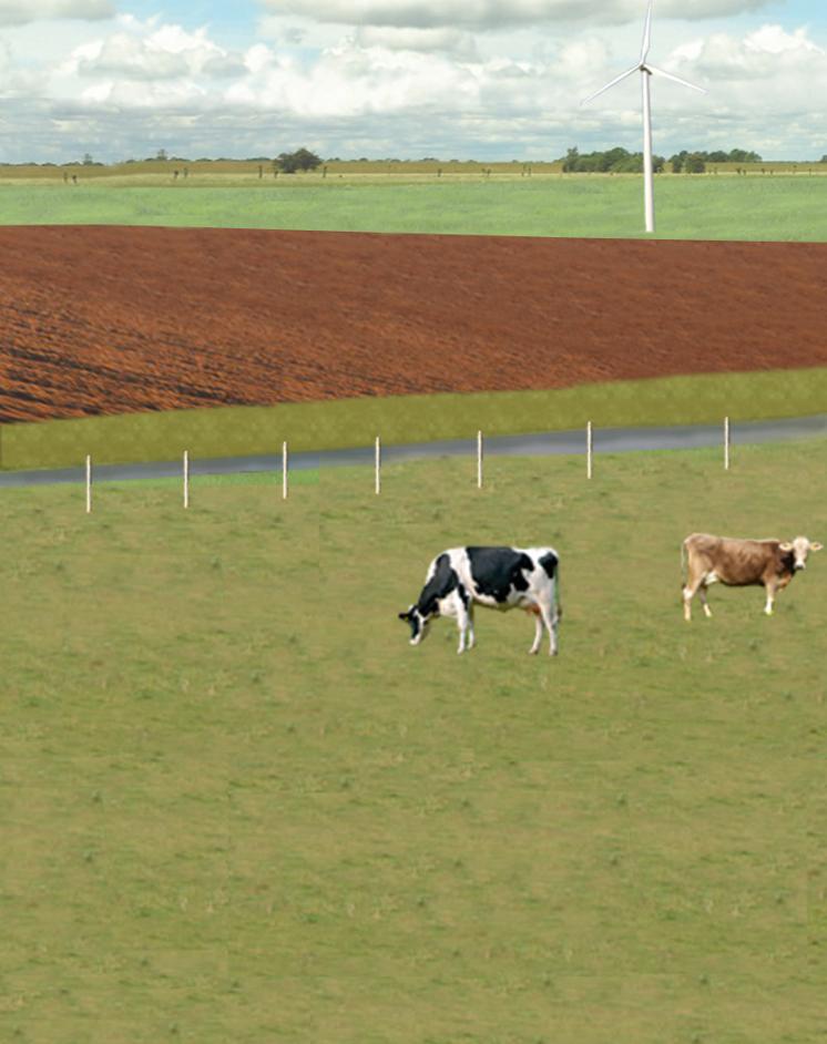
In the 19th and 20th century land was reclaimed from the sea to make use of the exposed fertile soils for agriculture through a process known as ‘impoldering’. The reclaimed land is now characterized by intensive grazing and cropland. This is a region where agriculture is the most important form of land use. However, the land needs to be regularly drained. Given the expected increase in precipitation in winter due to climate change, the corresponding increase in freshwater discharge needs to be managed. Furthermore, the periods when natural discharge into the sea oc-curs are likely to decrease – because of rising sea levels also caused by climate change. Consequently, in winter and spring, greater quantities of freshwater will need to be pumped into the sea rather than discharged naturally at the low or ‘ebb’ tide. Specially embanked water retention polders will be required to temporarily impound water as part of a multifunctional approach to coastal zone management.
Purpose of the Technology: These retention polders could be a cost-effective alternative to expensive invest-ments in extra pumping capacities to prevent submergence of low-lying cultivated areas. The primary aim is to restrict floods to the retention polders when the drain-age network is overburdened and cannot deal with the predicted extra demands in the future. The high evapotranspiration from the open waterbody, and the reeds growing within, will also help with reducing the amount of water. During dry sum-mers, the water in the retention polder could also be put to creative use as a source of irrigation. Another potential advantage is that subsurface saltwater intrusion in the region could be prevented by the freshwater-filled polders. During extreme storm surges and in the rare case of breaches in the sea wall, the retention polders would serve as an extra line of defence by holding seawater.
Establishment / maintenance activities and inputs: An embankment enclosing approx. 500 ha will be able to store up to 2,500,000 m³ of water. This will improve the drainage of an area of approx. 49,000 ha. The invest-ment for building this water retention area is high – but for the reasons stated it serves a necessary purpose at a cost which is lower than the alternative – increased pumped drainage installations. Maintenance costs will be lower than the drainage alternative as only the integrity of the embankment needs to be monitored regularly. Currently, agricultural land use within the polders is adapted to higher water levels and occasional flooding. Within the embanked area there will be a change from the current use of mainly crop land to extensive grazing, open water and reed stands.
Natural / human environment: Some parts within the retention polder will be used for agricultural purposes, while the wetter parts will be set aside. In these latter sections, undisturbed natural regen-eration will take place. A landscape comprising various different elements, without any extreme forms of intensive land use such as large areas of monocultures will be the result. Thus requirements for agricultural use and tourism will be addressed.
2.3 Фотографии, иллюстрирующие Технологию
Медиа-галерея
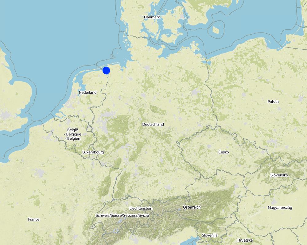
2.5 Страна/ регион/ места, где применяется Технология, информация о которых собрана в данной Анкете
Страна:
Германия
Административная единица (Район/Область):
Germany, Lower Saxony
Более точная привязка места:
Landkreis Aurich
Пояснения:
Total area covered by the SLM Technology is 33.7 km2.
Map
×2.6 Сколько лет применяется данная Технология
Если год начала применения Технологии достоверно неизвестен, дайте примерную оценку:
- 10-50 лет назад
2.7 Внедрение Технологии
Укажите, как именно Технология УЗП была внедрена:
- в качестве научного/ полевого эксперимента
- через проекты/ внешнее вмешательство
3. Классификация Технологии УЗП
3.2 Текущий(-ие) тип(-ы) землепользования на территории, где применяется Технология
Комбинированное землепользование в пределах одной и той же земельной единицы:
Да
Укажите сочетания типов землепользования (посевы / пастбища / деревья):
- Агро-пастбищное хозяйство ( включая растениеводство-животноводство)

Пахотные угодья и плантации

Пастбищные угодья
Интенсивный выпас/ выращивание кормов:
- Стойловое содержание/ нулевой выпас
- Улучшенные пастбища
Вид животных:
- крупный рогатый скот - молочный
- крупный рогатый скот - немолочная говядина
Продукты и услуги:
- мясо
- молоко
Пояснения:
Major land use problems (compiler’s opinion): Flood events and droughts may substantially disrupt the contemporary land use in the future and lead to higher drainage costs and higher economic risks for agricultural production. This may reduce the ecological and economic viability of the current intensive and highly productive land use under a changing climate.
Major land use problems (land users’ perception): There is no awareness of risks due to climate change in the land users point of view.
Cut-and-carry/ zero grazing: cows for milk
Improved pasture: cattle for milk and meat
Future (final) land use (after implementation of SLM Technology): Other: Oo: Other: wastelands, deserts, glaciers, swamps, recreation areas, etc
Constraints of infrastructure network (roads, railways, pipe lines, power lines): needs to be adapted to regular flooding
Constraints of recreation (landscape is used for recreation and tourism ): change in landscape due to retention area
Constraints of nature conservation area (protected sites): wetter conditions in retention area
Number of growing seasons per year: 1
Longest growing period in days: 240Longest growing period from month to month: March to October
Livestock density: > 100 LU /km2
3.3 Изменилось ли использование земель в связи с внедрением Технологии?
Изменилось ли использование земель в связи с внедрением Технологии?
- Да (Пожалуйста, заполните нижеприведенные вопросы относительно использования земель до внедрения Технологии)

Водотоки, водные объекты, водно-болотные угодья
- Болота, водно-болотные угодья

Непродуктивные земли
Поясните:
wastelands
Пояснения:
Mixed: Mp: Agro-pastoralism
3.4 Водоснабжение
Пояснения:
Water supply: rainfed, mixed rainfed - irrigated
3.5 Категория УЗП, к которой относится Технология
- управление поверхностными водами (родники, реки, озёра, моря)
- Охрана/ управление водно-болотными угодьями
- Flood prevention
3.6 Мероприятия УЗП, выполняемые в рамках Технологии

инженерные мероприятия
- И5: Дамбы, водохранилища, пруды

управленческие мероприятия
- У1: Смена типа землепользования
- У2: Изменение формы/ интенсивности хозяйствования
Пояснения:
Main measures: structural measures
Secondary measures: management measures
3.7 Основные проблемы деградации земель, на решение которых направлена Технология

ухудшение химических свойств почв
- Хс: засоление/ подщелачивание

деградация водных ресурсов
- Вуп: изменение объема поверхностного стока
- Вуг: изменения уровня грунтовых вод/ водоносных горизонтов
- Взг: снижение качества грунтовых вод
Пояснения:
Main type of degradation addressed: Hs: change in quantity of surface water
Secondary types of degradation addressed: Cs: salinisation / alkalinisation, Hg: change in groundwater / aquifer level, Hq: decline of groundwater quality
Main causes of degradation: change of seasonal rainfall (Climate change, higher rainfall in winter, lower in summer), Heavy / extreme rainfall (intensity/amounts) (Heavy rainfall in winter due to climate change expected), floods (Flooding due to heavy rainfall in winter)
Secondary causes of degradation: droughts (Droughts due to less rainfall in summer (climate change)), other natural causes (avalanches, volcanic eruptions, mud flows, highly susceptible natural resources, extreme topography, etc.) specify (Sea level rise)
3.8 Предотвращение и снижение деградации земель, или восстановление нарушенных земель
Укажите цель Технологии по отношению к деградации земель :
- предотвращение деградации земель
- снижение деградации земель
Пояснения:
Main goals: prevention of land degradation
Secondary goals: mitigation / reduction of land degradation
4. Технические характеристики, мероприятия по практической реализации, вложения и стоимость
4.1 Технический рисунок, иллюстрирующий Технологию
Спецификация (пояснения к техническому рисунку):
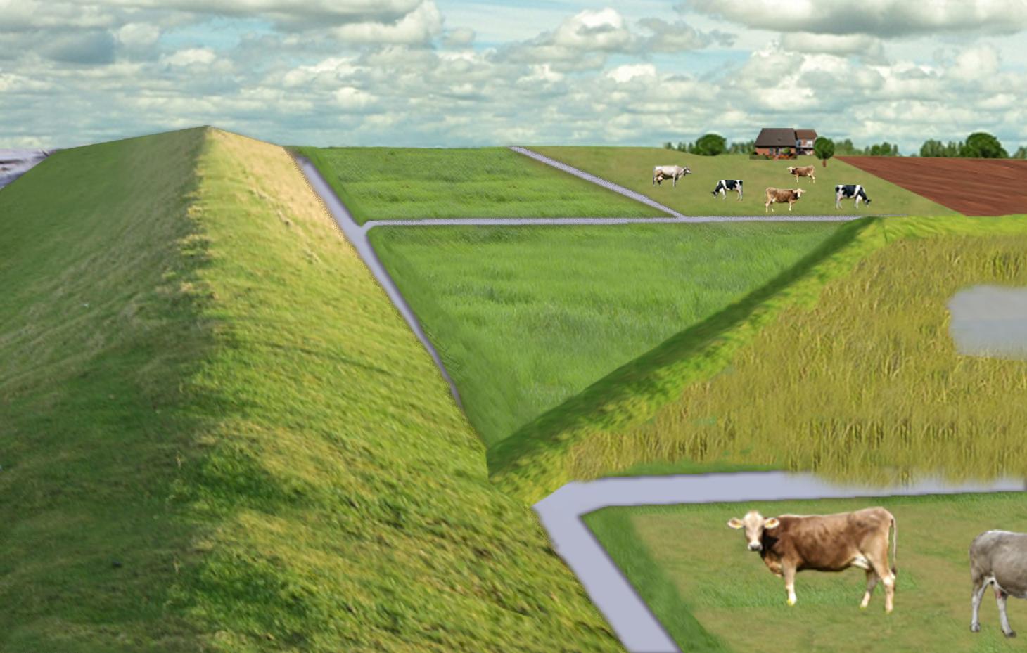
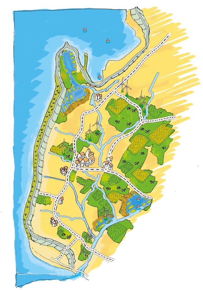
The figure shows the study region, located on the North Sea coast. The whole area is protected by a sea wall (grey). Crop fields (yellow), grasslands (green) and the drainage system (light blue) char-acterize the region. In contrast to T_GER001en and T_GER002en small water bodies (blue) surrounded by reeds (brown) act as water retention polders. Agricultural land use in some retention areas is adapted to the ground water levels and flooding frequencies. This results in parts of the retention areas being taken out of agricultural production and undisturbed development of natural habitats occurring. In other parts of the retention areas extensive grazing or reed farming will be practiced. This leads to a mosaic of different land uses in the landscape. Retention areas of 500 ha are able to store up to 2,500,000 m³ water. The height of the dams depends on the elevation of the landscape but in general a height of less than 2 m is sufficient.
Location: Krummhörn. County of Aurich, Lower Saxony
Technical knowledge required for field staff / advisors: high (To generate income in the retention area (without existing agricultural methods))
Technical knowledge required for water board: high (To build a new adapted drainage system with retention areas)
Main technical functions: control of dispersed runoff: retain / trap, control of concentrated runoff: retain / trap
Secondary technical functions: increase / maintain water stored in soil, increase of groundwater level / recharge of groundwater, spatial arrangement and diversification of land use
Dam/ pan/ pond
Height of bunds/banks/others (m): 1
Width of bunds/banks/others (m): 2
Length of bunds/banks/others (m): 13000
Construction material (earth): sand core and clay cover
Specification of dams/ pans/ ponds: Capacity 2500000m3
Catchment area: 49000ham2
Beneficial area: 49000ham2
Other specifications: size of retention area (embanked area): 500.00 ha
Change of land use type: Within the retention area the conditions are wetter than before. Therefore the agricultural land use needs to be changed to an adapted land use.
Change of land use practices / intensity level: Under the wetter conditions only a less intensive land use is possible, e.g. no crop fields but instead extensive grazing or cessation of agricultural land use.
Автор:
Udo Schotten
4.2 Общая информация по необходимым вложениям и стоимости
другая/ национальная валюта (название):
Euro
Если это необходимо, укажите обменный курс от доллара США к местной валюте (например, 1 доллар США = 79,9 бразильского реала): 1 доллар США =:
0,94
Укажите среднюю дневную заработную плату наемных работников:
100.00
4.3 Мероприятия, необходимые для начала реализации
| Деятельность | Время (сессия) | |
|---|---|---|
| 1. | Building of dams | during winter months |
4.4 Вложения и затраты, необходимые для начала реализации
| Опишите затраты | Единица | Количество | Затраты на единицу | Общая стоимость на единицу | % затрат, оплаченных землепользователями | |
|---|---|---|---|---|---|---|
| Оплата труда | Labour | Dam | 1,0 | 10000000,0 | 10000000,0 | |
| Оборудование | Machine use | Dam | 1,0 | 4000000,0 | 4000000,0 | |
| Строительные материалы | Earth | Dam | 1,0 | 112000,0 | 112000,0 | |
| Общая стоимость запуска Технологии | 14112000,0 | |||||
| Общие затраты на создание Технологии в долларах США | 15012765,96 | |||||
Пояснения:
Duration of establishment phase: 3 month(s)
4.5 Поддержание/ текущее обслуживание
| Деятельность | Сроки/ повторяемость проведения | |
|---|---|---|
| 1. | Control of dams | once a year |
| 2. | Maintenance of dams | once a year |
| 3. | Maintenance of drainage system | once a year (mean of many years) |
4.6 Стоимость поддержания/ текущего обслуживания ( в год)
| Опишите затраты | Единица | Количество | Затраты на единицу | Общая стоимость на единицу | % затрат, оплаченных землепользователями | |
|---|---|---|---|---|---|---|
| Оплата труда | Labour | Dam | 1,0 | 500,0 | 500,0 | |
| Оборудование | Machine use | Dam | 1,0 | 200,0 | 200,0 | |
| Строительные материалы | Earth | Dam | 1,0 | 100,0 | 100,0 | |
| Другие | Maintenance per km ditch | Dam | 1,0 | 2270,7 | 2270,7 | |
| Общая стоимость поддержания Технологии | 3070,7 | |||||
| Общие затраты на поддержание Технологии в долларах США | 3266,7 | |||||
Пояснения:
Machinery/ tools: digger, open truck
The main investment is based on a dam length of 13 km to build up the retention area of a size of 500 ha. The length of the drainage network for the whole watershed (retention area and the surroundings) is 1,134 km. Maintenance costs of drainage network are based on long term annual mean cost of 2,270.72 Euro per km including pumping costs.
4.7 Наиболее значимые факторы, влияющие на стоимость затрат
Опишите наиболее значимые факторы, влияющие на стоимость затрат:
The establishment costs are for the whole retention area (500 ha). The establishment period will be half a year.
Mainly the elevation in the region determines the costs as the height of the dams depend on the elevation. Typical heights are 1 m up to 2 m with a slope of 1:3.
5. Природные и социально-экономические условия
5.1 Климат
Среднегодовое количество осадков
- < 250 мм
- 251-500 мм
- 501-750 мм
- 751-1000 мм
- 1001-1500 мм
- 1501-2000 мм
- 2001-3000 мм
- 3001-4000 мм
- > 4000 мм
Агроклиматическая зона
- влажная
Thermal climate class: temperate
5.2 Рельеф
Склоны (преобладающие):
- пологие (0-2%)
- покатые (3-5%)
- покато-крутые (6-10%)
- крутые (11-15%)
- очень крутые (16-30%)
- чрезвычайно крутые (31-60%)
- обрывистые (>60%)
Формы рельефа:
- плато/ равнины
- гребни хребтов/холмов
- склоны гор
- склоны холмов
- подножья
- днища долин
Зона высотной поясности:
- 0-100 м над уровнем моря
- 101-500 м н.у.м.
- 501-1000 м н.у.м.
- 1001-1500 м н.у.м.
- 1501-2000 м н.у.м.
- 2001-2500 м н.у.м.
- 2501-3000 м н.у.м.
- 3001-4000 м н.у.м.
- > 4 тыс. м н.у.м.
5.3 Почвы
Средняя мощность почв:
- поверхностные (0-20 см)
- неглубокие (21-50 см)
- умеренно глубокие (51-80 см)
- глубокие (81-120 см)
- очень глубокие (> 120 см)
Гранулометрический состав (верхнего горизонта):
- тонкодисперсный/ тяжёлый (глинистый)
Содержание органического вещества в верхнем горизонте:
- высокое (> 3%)
Если возможно, приложите полное описание почв или укажите доступную информацию, например тип почв, рH/ кислотность почв, ёмкость катионного обмена, содержание азота, содержание солей и т.д.
Soil fertility is high
Soil drainage/infiltration is meidum
Soil water storage capacity is high
5.4 Доступность и качество воды
Уровень грунтовых вод:
< 5 м
Доступность поверхностных вод:
хорошая
Качество воды (без обработки):
исключительно для сельскохозяйственного использования (орошение)
5.5 Биоразнообразие
Видовое разнообразие:
- низкое
5.6 Характеристика землепользователей, применяющих Технологию
Рыночная ориентация производства:
- товарное/ рыночное хозяйство
Доходы из других источников:
- 10-50% всех доходов
Относительный уровень достатка:
- средний
Индивидуальное или коллективное хозяйство:
- использующее наемных работников (компания, государство)
Уровень механизации:
- механизировано/ есть автотранспорт
Пол:
- женщины
- мужчины
Укажите другие важные характеристики землепользователей:
Land users applying the Technology are mainly common / average land users
Population density: 50-100 persons/km2
Annual population growth: < 0.5%
1% of the land users are very rich and own 1% of the land.
49% of the land users are rich and own 24% of the land.
50% of the land users are average wealthy and own 50% of the land.
and own 25% of the land.
Off-farm income specification: Many farmers do additional work in companies
5.7 Средняя площадь земель, используемых землепользователями с применением Технологии
- < 0,5 га
- 0,5-1 га
- 1-2 га
- 2-5 га
- 5-15 га
- 15-50 га
- 50-100 га
- 100-500 га
- 500-1000 га
- 1000-10000 га
- > 10000 га
Считается ли это мелким, средним или крупным хозяйством (по местным масштабам)?
- крупное
Пояснения:
Average area of land owned or leased by land users applying the Technology: 5-15 ha, 15-50 ha, 50-100 ha, 100-500 ha
5.8 Собственность на землю, права на земле- и водопользование
Землевладелец:
- индивидуальная, не оформленная в собственность
Право землепользования:
- индивидуальное
5.9 Доступ к базовым услугам и инфраструктуре
медицинское обслуживание:
- плохой
- средний
- хорошая
образование:
- плохой
- средний
- хорошая
технические консультации:
- плохой
- средний
- хорошая
занятость (вне хозяйства):
- плохой
- средний
- хорошая
рынки:
- плохой
- средний
- хорошая
электроснабжение:
- плохой
- средний
- хорошая
транспорт и дорожная сеть:
- плохой
- средний
- хорошая
водоснабжение и канализация:
- плохой
- средний
- хорошая
финансовые услуги:
- плохой
- средний
- хорошая
6. Воздействия и заключительные положения
6.1 Влияние Технологии УЗП в пределах территории ее применения
Социально-экономическое воздействие
Продуктивность
производство сельскозяйственных культур
Комментарий/ пояснения:
Under wet conditions in the retention area a crop production is not possible any more.
производство кормов
Комментарий/ пояснения:
Under wet conditions in the retention area an intensive fodder production is not possible any more.
качество кормов
Комментарий/ пояснения:
Under wet conditions in the retention area the optiomal fodder quality can not ensured any more.
риск потери продуктивности
Комментарий/ пояснения:
Regarding crops: The retention area is used for excess water and may be flooded during growing season.
Доходы и затраты
сельскохозяйственные издержки
Комментарий/ пояснения:
Only adjusted land use takes place, therefore the expenses are reduced nearly to 0.
доходы хозяйства
разнообразие источников дохода
Комментарий/ пояснения:
Due to land use adapted to the conditions the typical land use is not possible and a diversitfication will take place with reed mowing and extensive grazing in the retention area.
Другое социально-экономическое воздействие
Intrusion by saline groundwater
Социальное и культурное воздействие
возможности отдыха и рекреации
Комментарий/ пояснения:
Diversification of landscape by building the retention area will increase the attractivity for recreation and tourists.
знания в области УЗП/ деградации земель
Комментарий/ пояснения:
Less intensive land use results in more diversity and conservation of regional species and habitats.
смягчение конфликтов
Improved livelihoods and human well-being
Комментарий/ пояснения:
'Regional belonging' and 'feeling of safety' are measured. The amount of increase is modelled and will be added here.
Экологическое воздействие
Водный цикл/ поверхностный сток
количество воды
Комментарий/ пояснения:
Typical for the region are wet situations. These typical wet conditions are restored by cessation of drainage system within the retention area.
качество воды
Комментарий/ пояснения:
Updwelling of saline groundwater is prevented by increased water level in the retention area.
уровень грунтовых/ подземных вод
Комментарий/ пояснения:
By water in the retention are the recharge of groundwater will increase and prevent salinization.
испарение
Комментарий/ пояснения:
Instead of pumping water into the sea a higher amount is evapotranspirated naturally.
Почвы
влажность почв
Комментарий/ пояснения:
Typical for the region are wet situations. These typical wet conditions are restored by cessation of drainage system within the retention area.
засоленность
Комментарий/ пояснения:
By water in the retention are the recharge of groundwater will increase and prevent salinization.
почвенное / подземное органическое вещество/ углерод
Комментарий/ пояснения:
By wetter conditions the soil organic matter will be increased.
Биоразнообразие: растительность, животный мир
разнообразие флоры
Комментарий/ пояснения:
By diversification of land use the number of species will be increased, especially due to extensive land use.
разнообразие фауны
Комментарий/ пояснения:
By diversification of land use the number of species will be increased, especially due to extensive land use.
разнообразие местообитаний
Комментарий/ пояснения:
By diversification of land use the number of habitats will be increased.
Климат и снижение риска стихийных бедствий
выбросы углекислого газа и парниковых газов
Комментарий/ пояснения:
Modelled is the global warming potential by gas emissions. Not yet clear if it is benefit or disadvantage. Model will show.
6.2 Влияние Технологии за пределами территории ее применения
доступность воды
надежность и постоянство водотоков
Комментарий/ пояснения:
Water stored in retention area can be used for irrigation during dry summer months.
подтопление ниже по течению
Комментарий/ пояснения:
Measured m3 of excess water in the catchment area, leading to floods or needs to be pumped. Exact values from modelling will be added as soon as possible!
ущерб прилегающим полям
ущерб объектам инфраструктуры общего/ частного пользования
Reduced hazard towards adverse events
6.3 Подверженность и чувствительность Технологии УЗП к постепенным изменениям климата и экстремальным погодным явлениям/ стихийным бедствиям, связанным с изменением климата (в понимании землепользователей)
Постепенное изменение климата
Постепенное изменение климата
| Сезон | увеличение или уменьшение | Насколько успешно Технология справляется с этим? | |
|---|---|---|---|
| среднегодовые температуры | увеличилось | хорошо |
Экстремальные явления, связанные с изменением климата (стихийные бедствия)
Погодные стихийные бедствия
| Насколько успешно Технология справляется с этим? | |
|---|---|
| местные ливневые дожди | хорошо |
| местные ураганы | хорошо |
Стихийные бедствия климатического характера
| Насколько успешно Технология справляется с этим? | |
|---|---|
| засухи | хорошо |
Гидрологические стихийные бедствия
| Насколько успешно Технология справляется с этим? | |
|---|---|
| регулярные наводнения (выход рек из берегов) | хорошо |
Другие воздействия, связанные с изменением климата
Другие воздействия, связанные с изменением климата
| Насколько успешно Технология справляется с этим? | |
|---|---|
| сокращение вегетационного периода | не известно |
6.4 Анализ эффективности затрат
Насколько получаемый результат сопоставим с первоначальными вложениями (с точки зрения землепользователей)?
Эффективность затрат в краткосрочной перспективе:
отрицательно
Эффективность затрат в долгосрочной перспективе:
слабо позитивное
Насколько получаемый результат сопоставим с текущими расходами по поддержанию технологии (с точки зрения землепользователей)?
Эффективность затрат в краткосрочной перспективе:
слабо позитивное
Эффективность затрат в долгосрочной перспективе:
очень позитивное
Пояснения:
The benefits will be visible in an longer time frame. There will be benefits of the investments when considering sea level rise in the upcoming 100 years.
6.5 Внедрение Технологии
Пояснения:
Comments on spontaneous adoption: The SLM Technology is not implemented by land users but needs to be implemented in spatial planning of the federal state. We expect that there is a chance for implementation.
There is a strong trend towards spontaneous adoption of the Technology
Comments on adoption trend: The SLM Technology was developed together with regional experts. It seems that the ideas developed, merge more often in their recent discussion and an implementation is likely.
6.7 Сильные стороны/ преимущества/ возможности Технологии
| Сильные стороны/ преимущества/ возможности по мнению землепользователей |
|---|
|
The retention area will supplement the drainage of the arable fields and pastures outside the retention area How can they be sustained / enhanced? Combine with other technical solutions for protection against flooding. |
| Сильные стороны/ преимущества/ возможности по мнению составителя или других ключевых специалистов |
|---|
|
Prevention of flooding during strong rainfalls and possibility to irrigate during dry periods How can they be sustained / enhanced? The larger the retention areas are the more water can be stored |
|
Prevention of salt water intrusion in the region How can they be sustained / enhanced? Fresh water in the retention areas prevents saline ground water from intrusion. Build polders in areas where saline ground water intrudes. |
|
Endangered species might obtain new habitats in the retention area How can they be sustained / enhanced? Extensive land use can help to optimize the habitats for endan-gered species and increase attractiveness for tourism. |
|
Through investments in building retention polders the very ex-pensive strengthening of the existing drainage system is no longer necessary. How can they be sustained / enhanced? By increasing the attractiveness for tourism alternative benefits for land owner can be generated. |
|
Multi-functional land use in the catchment and in the retention area How can they be sustained / enhanced? Support farmers with land in the retention area (e.g. financially or with additional agricultural land outside the retention area). Sup-port discussions between farmers’ associations and nature con-servation agencies. |
6.8 Слабые стороны/ недостатки/ риски Технологии и пути их преодоления
| Слабые стороны/ недостатки/ риски по мнению землепользователей | Возможные пути их преодоления/снижения? |
|---|---|
| The retention polders will change the landscape and this may reduce the value of the region for tourism | Include tourist concerns within the retention area (accessibility, information, attractiveness) |
| Endangered species might lose habitats when building up the retention polders | Do not build a retention area where endangered species live |
| Loss of livelihoods | Retention areas should be planned for parts of the landscape without settlements |
| Слабые стороны/ недостатки/ риски по мнению составителя или ответственных специалистов | Возможные пути их преодоления/снижения? |
|---|---|
| Loss of land for agricultural production | Create retention polders where the productivity is already low. Encourage alternative land use (for example reed production) in the retention polders. |
| High water levels (especially with changing levels) may generate high emissions of greenhouse gases. | Ground water levels should kept stable near to the soil surface. |
| Retention area is probably too small if pessimistic sea level rise predictions come true. | Increase size of retention polders. |
7. Справочные материалы и ссылки
7.1 Методы сбора/ источники информации
7.2 Ссылки на опубликованные материалы
Название, автор, год публикации, ISBN:
http://www.comtess.uni-oldenburg.de/
7.3 Ссылки на соответствующую онлайн-информацию
Название/ описание:
http://www.comtess.uni-oldenburg.de/
Ссылки и модули
Развернуть все Свернуть всеСсылки
Stakeholder participation in integrated assessment and planning of … [Германия]
Stakeholders have been involved in integrated assessment to develop action-oriented land use options addressing possible climate change adaptation measures as alternatives to traditional coastal protection strategies.
- Составитель: Martin Maier
Модули
Нет модулей