Water retention polders to improve water management [ເຢຍລະມັນ]
- ການສ້າງ:
- ປັບປູງ:
- ຜູ້ສັງລວມຂໍ້ມູນ: Martin Maier
- ບັນນາທິການ: –
- ຜູ້ທົບທວນຄືນ: Fabian Ottiger, David Streiff, Alexandra Gavilano
Polder zum Wassermanagement entwickelt durch lokale Experten (Nordsee Region)
technologies_1583 - ເຢຍລະມັນ
ເບິ່ງພາກສ່ວນ
ຂະຫຍາຍທັງໝົດ ຍຸບທັງໝົດ1. ຂໍ້ມູນທົ່ວໄປ
1.2 ຂໍ້ມູນ ການຕິດຕໍ່ພົວພັນ ຂອງບຸກຄົນທີ່ສໍາຄັນ ແລະ ສະຖາບັນ ທີ່ມີສ່ວນຮ່ວມ ໃນການປະເມີນເອກກະສານ ເຕັກໂນໂລຢີ
ບັນດາຜູ້ຕອບແບບສອບຖາມທີ່ສໍາຄັນ ()
ຜຸ້ຊ່ຽວຊານ ດ້ານການຄຸ້ມຄອງ ທີ່ດິນແບບຍືນຍົງ:
Kleyer Michael
University of Oldenburg
ເຢຍລະມັນ
ຜຸ້ຊ່ຽວຊານ ດ້ານການຄຸ້ມຄອງ ທີ່ດິນແບບຍືນຍົງ:
Karrasch Leena
University of Oldenburg
ເຢຍລະມັນ
ຜຸ້ຊ່ຽວຊານ ດ້ານການຄຸ້ມຄອງ ທີ່ດິນແບບຍືນຍົງ:
Mayer Martin
University of Oldenburg
ເຢຍລະມັນ
ຊື່ໂຄງການ ທີ່ອໍານວຍຄວາມສະດວກ ໃນການສ້າງເອກກະສານ/ປະເມີນ ເຕັກໂນໂລຢີ (ຖ້າກ່ຽວຂ້ອງ)
Book project: Making sense of research for sustainable land management (GLUES)ຊື່ໂຄງການ ທີ່ອໍານວຍຄວາມສະດວກ ໃນການສ້າງເອກກະສານ/ປະເມີນ ເຕັກໂນໂລຢີ (ຖ້າກ່ຽວຂ້ອງ)
Sustainable Coastal Land Management (COMTESS / GLUES)ຊື່ສະຖາບັນ (ຫຼາຍສະຖາບັນ) ທີ່ອໍານວຍຄວາມສະດວກ ໃນການສ້າງເອກກະສານ / ປະເມີນ ເຕັກໂນໂລຢີ (ຖ້າກ່ຽວຂ້ອງ)
University of Oldenburg (University of Oldenburg) - ເຢຍລະມັນ1.3 ເງື່ອນໄຂ ກ່ຽວກັບ ການນໍາໃຊ້ຂໍ້ມູນເອກະສານ ທີ່ສ້າງຂື້ນ ໂດຍຜ່ານ ອົງການພາບລວມຂອງໂລກ ທາງດ້ານແນວທາງ ແລະ ເຕັກໂນໂລຢີ ຂອງການອານຸລັກ ທໍາມະຊາດ (WOCAT)
ຜູ້ປ້ອນຂໍ້ມູນ ແລະ ບຸກຄົນສຳຄັນ ທີ່ໃຫ້ຂໍ້ມູນ (ຫຼາຍ) ຍິນຍອມ ຕາມເງື່ອນໄຂ ໃນການນຳໃຊ້ຂໍ້ມູນ ເພື່ອສ້າງເປັນເອກກະສານຂອງ WOCAT:
ແມ່ນ
1.5 ແບບສອບຖາມທີ່ອ້າງອີງເຖີງແນວທາງ ການຄຸ້ມຄອງທີ່ດິນແບບຍືນຍົງ (ໄດ້ເຮັດເປັນເອກະສານທີ່ໃຊ້ WOCAT)
Stakeholder participation in integrated assessment and planning of … [ເຢຍລະມັນ]
Stakeholders have been involved in integrated assessment to develop action-oriented land use options addressing possible climate change adaptation measures as alternatives to traditional coastal protection strategies.
- ຜູ້ສັງລວມຂໍ້ມູນ: Martin Maier
2. ການອະທິບາຍ ເຕັກໂນໂລຢີ ຂອງການຄຸ້ມຄອງ ທີ່ດິນແບບຍືນຍົງ
2.1 ຄໍາອະທິບາຍສັ້ນຂອງ ເຕັກໂນໂລຢີ
ການກຳໜົດຄວາມໝາຍ ຂອງເຕັກໂນໂລຢີ:
Water retaining polders to reduce flood risk due to heavy rainfall or runoff at high tide in embanked coastal lowlands. Delineation of the retention area and land use within the retention area was developed in a participatory process with local experts.
2.2 ການອະທິບາຍ ລາຍລະອຽດ ຂອງເຕັກໂນໂລຢີ
ການພັນລະນາ:
In the 19th and 20th century land was reclaimed from the sea to make use of the exposed fertile soils for agriculture through a process known as ‘impoldering’. The reclaimed land is now characterized by intensive grazing and cropland. This is a region where agriculture is the most important form of land use. However, the land needs to be regularly drained. Given the expected increase in precipitation in winter due to climate change, the corresponding increase in freshwater discharge needs to be managed. Furthermore, the periods when natural discharge into the sea oc-curs are likely to decrease – because of rising sea levels also caused by climate change. Consequently, in winter and spring, greater quantities of freshwater will need to be pumped into the sea rather than discharged naturally at the low or ‘ebb’ tide. Specially embanked water retention polders will be required to temporarily impound water as part of a multifunctional approach to coastal zone management.
Purpose of the Technology: These retention polders could be a cost-effective alternative to expensive invest-ments in extra pumping capacities to prevent submergence of low-lying cultivated areas. The primary aim is to restrict floods to the retention polders when the drain-age network is overburdened and cannot deal with the predicted extra demands in the future. The high evapotranspiration from the open waterbody, and the reeds growing within, will also help with reducing the amount of water. During dry sum-mers, the water in the retention polder could also be put to creative use as a source of irrigation. Another potential advantage is that subsurface saltwater intrusion in the region could be prevented by the freshwater-filled polders. During extreme storm surges and in the rare case of breaches in the sea wall, the retention polders would serve as an extra line of defence by holding seawater.
Establishment / maintenance activities and inputs: An embankment enclosing approx. 500 ha will be able to store up to 2,500,000 m³ of water. This will improve the drainage of an area of approx. 49,000 ha. The invest-ment for building this water retention area is high – but for the reasons stated it serves a necessary purpose at a cost which is lower than the alternative – increased pumped drainage installations. Maintenance costs will be lower than the drainage alternative as only the integrity of the embankment needs to be monitored regularly. Currently, agricultural land use within the polders is adapted to higher water levels and occasional flooding. Within the embanked area there will be a change from the current use of mainly crop land to extensive grazing, open water and reed stands.
Natural / human environment: Some parts within the retention polder will be used for agricultural purposes, while the wetter parts will be set aside. In these latter sections, undisturbed natural regen-eration will take place. A landscape comprising various different elements, without any extreme forms of intensive land use such as large areas of monocultures will be the result. Thus requirements for agricultural use and tourism will be addressed.
2.3 ຮູບພາບຂອງເຕັກໂນໂລຢີ
ສື່ຮູບພາບ
2.5 ປະເທດ / ເຂດ / ສະຖານທີ່ບ່ອນທີ່ ເຕັກໂນໂລຢີ ໄດ້ຮັບການນໍາໃຊ້ ແລະ ທີ່ຖືກປົກຄຸມດ້ວຍການປະເມີນຜົນ
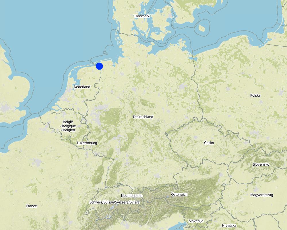
ປະເທດ:
ເຢຍລະມັນ
ພາກພື້ນ / ລັດ / ແຂວງ:
Germany, Lower Saxony
ຂໍ້ມູນເພີ່ມເຕີມຂອງສະຖານທີ່:
Landkreis Aurich
ຄວາມຄິດເຫັນ:
Total area covered by the SLM Technology is 33.7 km2.
Map
×2.6 ວັນທີໃນການຈັດຕັ້ງປະຕິບັດ
ຖ້າຫາກວ່າ ບໍ່ຮູ້ຈັກ ປີທີ່ຊັດເຈນ ແມ່ນໃຫ້ປະມານ ວັນທີເອົາ:
- 10-50 ປີ ຜ່ານມາ
2.7 ການນໍາສະເໜີ ເຕັກໂນໂລຢີ
ໃຫ້ລະບຸ ເຕັກໂນໂລຢີ ໄດ້ຖືກຈັດຕັ້ງປະຕິບັດຄືແນວໃດ?
- ໃນໄລຍະການທົດລອງ / ການຄົ້ນຄວ້າ
- ໂດຍຜ່ານໂຄງການ / ການຊ່ວຍເຫຼືອຈາກພາຍນອກ
3. ການໃຈ້ແຍກ ເຕັກໂນໂລຢີ ໃນການຄຸ້ມຄອງ ດິນແບບຍືນຍົງ
3.2 ປະເພດການນໍາໃຊ້ທີ່ດິນ ໃນປະຈຸບັນ() ທີ່ເຕັກໂນໂລຢີ ໄດ້ຖືກນໍາໃຊ້
ການນຳໃຊ້ທີ່ດິນ ປະສົມພາຍໃນພື້ນທີ່ດຽວກັນ:
ແມ່ນ
ລະບຸການນຳໃຊ້ທີ່ດິນແບບປະສົມ (ຜົນລະປູກ / ທົ່ງຫຍ້າລ້ຽງສັດ / ຕົ້ນໄມ້):
- ກະສິກໍາແບບປະສົມປະສານ (ລວມທັງ ການລ້ຽງສັດ-ປຸກຝັງ)

ດິນທີ່ປູກພືດ

ທົ່ງຫຍ້າລ້ຽງສັດ
ທົ່ງຫຍ້າລ້ຽງສັດແບບສຸມ / ການຜະລິດອາຫານສັດ:
- ຕັດຫຍ້າ ແລະ ຂົນຫຍ້າ / ບໍ່ມີທົ່ງຫຍ້າທໍາມະຊາດ
- ປັບປຸງ ທົ່ງຫຍ້າ
ປະເພດສັດ:
- ສັດໃຫ່ຍ-ງົວພັນນົມ
- ສັດໃຫ່ຍ-ງົວພັນຊີ້ນ
ຜະລິດຕະພັນ ແລະ ການບໍລິການ:
- ຊີ້ນ
- ນ້ຳນົມ
ຄວາມຄິດເຫັນ:
Major land use problems (compiler’s opinion): Flood events and droughts may substantially disrupt the contemporary land use in the future and lead to higher drainage costs and higher economic risks for agricultural production. This may reduce the ecological and economic viability of the current intensive and highly productive land use under a changing climate.
Major land use problems (land users’ perception): There is no awareness of risks due to climate change in the land users point of view.
Cut-and-carry/ zero grazing: cows for milk
Improved pasture: cattle for milk and meat
Future (final) land use (after implementation of SLM Technology): Other: Oo: Other: wastelands, deserts, glaciers, swamps, recreation areas, etc
Constraints of infrastructure network (roads, railways, pipe lines, power lines): needs to be adapted to regular flooding
Constraints of recreation (landscape is used for recreation and tourism ): change in landscape due to retention area
Constraints of nature conservation area (protected sites): wetter conditions in retention area
Number of growing seasons per year: 1
Longest growing period in days: 240Longest growing period from month to month: March to October
Livestock density: > 100 LU /km2
3.3 ການນຳໃຊ້ທີ່ດິນ ມີການປ່ຽນແປງຍ້ອນການຈັດຕັ້ງທົດລອງເຕັກໂນໂລຢີ ແມ່ນບໍ່?
ການນຳໃຊ້ທີ່ດິນ ມີການປ່ຽນແປງຍ້ອນການຈັດຕັ້ງທົດລອງເຕັກໂນໂລຢີ ແມ່ນບໍ່?
- ແມ່ນ (ກະລຸນາຕື່ມໃສ່ ຄຳຖາມຂ້າງລຸ່ມນີ້ກ່ຽວກັບການນຳໃຊ້ທີ່ດິນ ກ່ອນການທົດລອງເຕັກໂນໂລຢີ)

ທິດທາງໄຫຼຂອງນໍ້າ, ນໍ້າ, ດິນທາມ
- ໜອງ, ດິນທາມ

ດິນ ທີ່ບໍ່ອຸດົມສົມບູນ
ລະບຸ ຊະນິດ:
wastelands
ຄວາມຄິດເຫັນ:
Mixed: Mp: Agro-pastoralism
3.4 ການສະໜອງນ້ຳ
ຄວາມຄິດເຫັນ:
Water supply: rainfed, mixed rainfed - irrigated
3.5 ການນໍາໃຊ້ເຕັກໂນໂລຢີ ທີ່ຢູ່ໃນກຸ່ມການຄຸ້ມຄອງ ທີ່ດິນແບບຍືນຍົງ
- ການຄຸ້ມຄອງນໍ້າໜ້າດິນ (ນ້ຳຈາກພຸ, ແມ່ນໍ້າ, ທະເລສາບ, ທະເລ)
- ການຄຸ້ມຄອງ ແລະ ປ້ອງກັນເຂດດິນທາມ
- Flood prevention
3.6 ມາດຕະການ ການຄຸ້ມຄອງ ທີ່ດິນແບບຍືນຍົງ ປະກອບດ້ວຍ ເຕັກໂນໂລຢີ

ມາດຕະການໂຄງສ້າງ
- S5: ເຂື່ອນໄຟຟ້າ, ຝາຍເກັບນໍ້າ, ອ່າງ, ໜອງ

ມາດຕະການ ທາງດ້ານການຄຸ້ມຄອງ
- M1: ການປ່ຽນແປງ ປະເພດ ການນໍາໃຊ້ທີ່ດິນ
- M2: ການປ່ຽນແປງ ການຈັດການຄຸ້ມຄອງ / ລະດັບຄວາມໜາແໜ້ນ
ຄວາມຄິດເຫັນ:
Main measures: structural measures
Secondary measures: management measures
3.7 ປະເພດດິນເຊື່ອມໂຊມ ຫຼັກທີ່ໄດ້ນໍາໃຊ້ ເຕັກໂນໂລຢີ

ການເຊື່ອມໂຊມ ຂອງດິນ ທາງເຄມີ
- Cs: ການເຮັດໃຫ້ເກີດດິນເຄັມ / ເປັນດ່າງ

ການເຊື່ອມໂຊມ ຂອງນໍ້າ
- Hs: ການປ່ຽນແປງ ປະລິມານ ນໍ້າໜ້າດິນ
- Hg: ການປ່ຽນແປງ ລະດັບນ້ຳໃຕ້ດິນ ຫຼື ນ້ຳບາດານ
- Hq: ຄຸນນະພາບ ຂອງນ້ຳໃຕ້ດິນຫຼຸດລົງ
ຄວາມຄິດເຫັນ:
Main type of degradation addressed: Hs: change in quantity of surface water
Secondary types of degradation addressed: Cs: salinisation / alkalinisation, Hg: change in groundwater / aquifer level, Hq: decline of groundwater quality
Main causes of degradation: change of seasonal rainfall (Climate change, higher rainfall in winter, lower in summer), Heavy / extreme rainfall (intensity/amounts) (Heavy rainfall in winter due to climate change expected), floods (Flooding due to heavy rainfall in winter)
Secondary causes of degradation: droughts (Droughts due to less rainfall in summer (climate change)), other natural causes (avalanches, volcanic eruptions, mud flows, highly susceptible natural resources, extreme topography, etc.) specify (Sea level rise)
3.8 ການປ້ອງກັນ, ການຫຼຸດຜ່ອນ, ຫຼືການຟື້ນຟູຂອງການເຊື່ອມໂຊມຂອງດິນ
ໃຫ້ລະບຸ ເປົ້າໝາຍ ເຕັກໂນໂລຢີ ທີ່ພົວພັນ ກັບຄວາມເຊື່ອມໂຊມຂອງດິນ:
- ປ້ອງກັນການເຊື່ອມໂຊມຂອງດິນ
- ຫຼຸດຜ່ອນການເຊື່ອມໂຊມຂອງດິນ
ຄວາມຄິດເຫັນ:
Main goals: prevention of land degradation
Secondary goals: mitigation / reduction of land degradation
4. ຂໍ້ກໍາໜົດ, ກິດຈະກໍາການປະຕິບັດ, ວັດຖຸດິບ, ແລະຄ່າໃຊ້ຈ່າຍ
4.1 ເຕັກນິກ ໃນການແຕ້ມແຜນວາດ ເຕັກໂນໂລຢີ
ຄຸນລັກສະນະ ຂອງເຕັກນິກ (ທີ່ກ່ຽວຂ້ອງ ກັບການແຕ້ມແຜນວາດ ທາງດ້ານເຕັກນີກ):
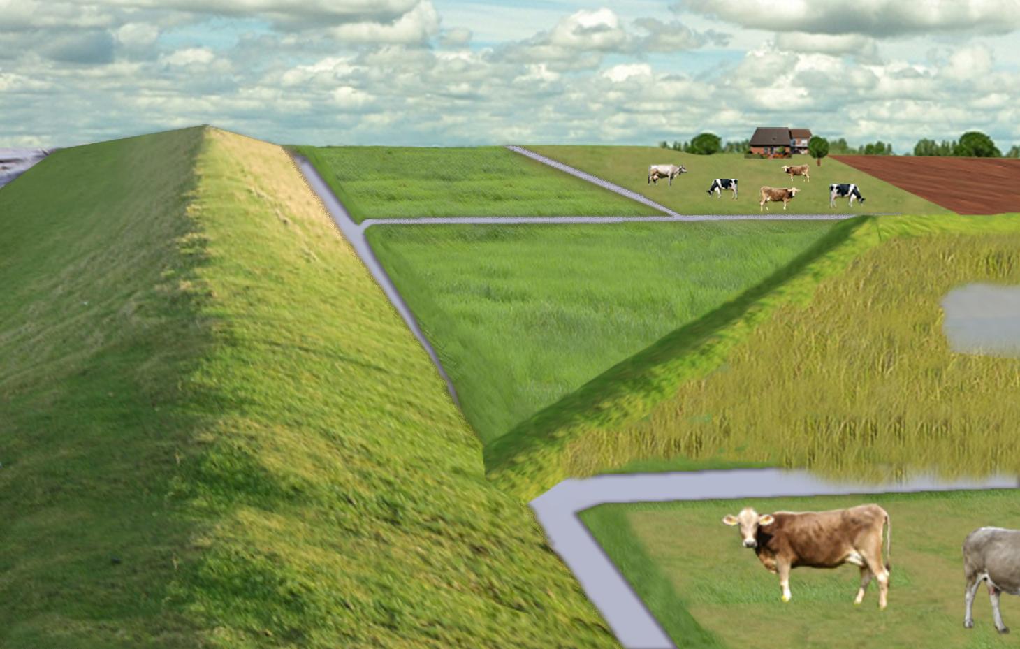
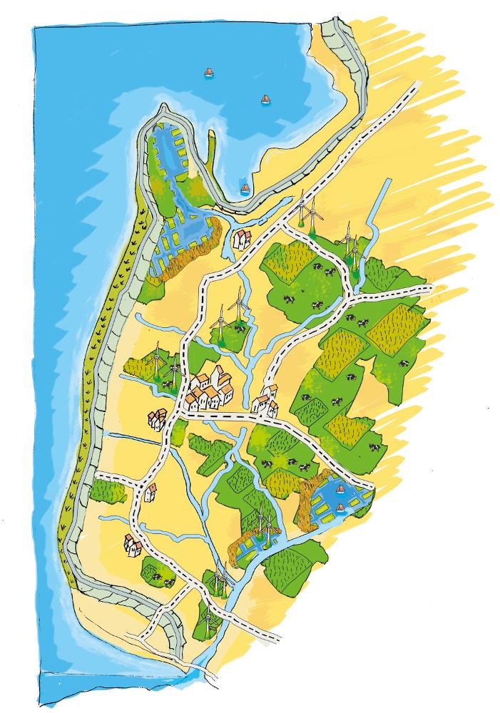
The figure shows the study region, located on the North Sea coast. The whole area is protected by a sea wall (grey). Crop fields (yellow), grasslands (green) and the drainage system (light blue) char-acterize the region. In contrast to T_GER001en and T_GER002en small water bodies (blue) surrounded by reeds (brown) act as water retention polders. Agricultural land use in some retention areas is adapted to the ground water levels and flooding frequencies. This results in parts of the retention areas being taken out of agricultural production and undisturbed development of natural habitats occurring. In other parts of the retention areas extensive grazing or reed farming will be practiced. This leads to a mosaic of different land uses in the landscape. Retention areas of 500 ha are able to store up to 2,500,000 m³ water. The height of the dams depends on the elevation of the landscape but in general a height of less than 2 m is sufficient.
Location: Krummhörn. County of Aurich, Lower Saxony
Technical knowledge required for field staff / advisors: high (To generate income in the retention area (without existing agricultural methods))
Technical knowledge required for water board: high (To build a new adapted drainage system with retention areas)
Main technical functions: control of dispersed runoff: retain / trap, control of concentrated runoff: retain / trap
Secondary technical functions: increase / maintain water stored in soil, increase of groundwater level / recharge of groundwater, spatial arrangement and diversification of land use
Dam/ pan/ pond
Height of bunds/banks/others (m): 1
Width of bunds/banks/others (m): 2
Length of bunds/banks/others (m): 13000
Construction material (earth): sand core and clay cover
Specification of dams/ pans/ ponds: Capacity 2500000m3
Catchment area: 49000ham2
Beneficial area: 49000ham2
Other specifications: size of retention area (embanked area): 500.00 ha
Change of land use type: Within the retention area the conditions are wetter than before. Therefore the agricultural land use needs to be changed to an adapted land use.
Change of land use practices / intensity level: Under the wetter conditions only a less intensive land use is possible, e.g. no crop fields but instead extensive grazing or cessation of agricultural land use.
ຜູ້ຂຽນ:
Udo Schotten
4.2 ຂໍ້ມູນທົ່ວໄປກ່ຽວກັບການຄິດໄລ່ປັດໃຈຂາເຂົ້າໃນການຜະລິດ ແລະ ມູນຄ່າອື່ນໆ
ສະກຸນເງິນອື່ນໆ / ປະເທດອື່ນໆ (ລະບຸ):
Euro
ຖ້າກ່ຽວຂ້ອງ, ໃຫ້ລະບຸອັດຕາແລກປ່ຽນຈາກ USD ເປັນສະກຸນເງິນທ້ອງຖິ່ນ (ເຊັ່ນ: 1 USD = 79.9 Brazilian Real): 1 USD =:
0.94
ລະບຸ ຄ່າຈ້າງ ຄ່າແຮງງານສະເລ່ຍ ຕໍ່ ວັນ:
100.00
4.3 ການສ້າງຕັ້ງກິດຈະກໍາ
| ກິດຈະກໍາ | Timing (season) | |
|---|---|---|
| 1. | Building of dams | during winter months |
4.4 ຕົ້ນທຶນ ແລະ ປັດໄຈຂາເຂົ້າທີ່ຈໍາເປັນໃນຈັດຕັ້ງປະຕິບັດ
| ລະບຸ ປັດໃຈ ນໍາເຂົ້າ ໃນການຜະລີດ | ຫົວໜ່ວຍ | ປະລິມານ | ຕົ້ນທຶນ ຕໍ່ຫົວໜ່ວຍ | ຕົ້ນທຶນທັງໝົດ ຂອງປັດໃຈຂາເຂົ້າ ໃນການຜະລິດ | % ຂອງຕົ້ນທຶນທັງໝົດ ທີ່ຜູ້ນໍາໃຊ້ທີ່ດິນ ໃຊ້ຈ່າຍເອງ | |
|---|---|---|---|---|---|---|
| ແຮງງານ | Labour | Dam | 1.0 | 10000000.0 | 10000000.0 | |
| ອຸປະກອນ | Machine use | Dam | 1.0 | 4000000.0 | 4000000.0 | |
| ວັດສະດຸກໍ່ສ້າງ | Earth | Dam | 1.0 | 112000.0 | 112000.0 | |
| ຕົ້ນທຶນທັງໝົດ ໃນການຈັດຕັ້ງປະຕິບັດ ເຕັກໂນໂລຢີ | 14112000.0 | |||||
| ຄ່າໃຊ້ຈ່າຍທັງໝົດ ສຳລັບການສ້າງຕັ້ງເຕັກໂນໂລຢີ ເປັນສະກຸນເງີນໂດລາ | 15012765.96 | |||||
ຄວາມຄິດເຫັນ:
Duration of establishment phase: 3 month(s)
4.5 ບໍາລຸງຮັກສາ / ແຜນຈັດຕັ້ງປະຕິບັດ ກິດຈະກໍາ
| ກິດຈະກໍາ | ໄລຍະເວລາ / ຄວາມຖີ່ | |
|---|---|---|
| 1. | Control of dams | once a year |
| 2. | Maintenance of dams | once a year |
| 3. | Maintenance of drainage system | once a year (mean of many years) |
4.6 ຄ່າໃຊ້ຈ່າຍ ແລະ ປັດໄຈນໍາເຂົ້າທີ່ຈໍາເປັນສໍາລັບການບໍາລຸງຮັກສາກິດຈະກໍາ / ແຜນປະຕິບັດ (ຕໍ່ປີ)
| ລະບຸ ປັດໃຈ ນໍາເຂົ້າ ໃນການຜະລີດ | ຫົວໜ່ວຍ | ປະລິມານ | ຕົ້ນທຶນ ຕໍ່ຫົວໜ່ວຍ | ຕົ້ນທຶນທັງໝົດ ຂອງປັດໃຈຂາເຂົ້າ ໃນການຜະລິດ | % ຂອງຕົ້ນທຶນທັງໝົດ ທີ່ຜູ້ນໍາໃຊ້ທີ່ດິນ ໃຊ້ຈ່າຍເອງ | |
|---|---|---|---|---|---|---|
| ແຮງງານ | Labour | Dam | 1.0 | 500.0 | 500.0 | |
| ອຸປະກອນ | Machine use | Dam | 1.0 | 200.0 | 200.0 | |
| ວັດສະດຸກໍ່ສ້າງ | Earth | Dam | 1.0 | 100.0 | 100.0 | |
| ອື່ນໆ | Maintenance per km ditch | Dam | 1.0 | 2270.7 | 2270.7 | |
| ຕົ້ນທຶນທັງໝົດ ທີ່ໃຊ້ໃນການບໍາລຸງຮັກສາ ເຕັກໂນໂລຢີ | 3070.7 | |||||
| ຄ່າໃຊ້ຈ່າຍທັງໝົດ ສຳລັບການບົວລະບັດຮກສາເຕັກໂນໂລຢີ ເປັນສະກຸນເງີນໂດລາ | 3266.7 | |||||
ຄວາມຄິດເຫັນ:
Machinery/ tools: digger, open truck
The main investment is based on a dam length of 13 km to build up the retention area of a size of 500 ha. The length of the drainage network for the whole watershed (retention area and the surroundings) is 1,134 km. Maintenance costs of drainage network are based on long term annual mean cost of 2,270.72 Euro per km including pumping costs.
4.7 ປັດໄຈ ທີ່ສໍາຄັນ ທີ່ສົ່ງຜົນກະທົບ ຕໍ່ຄ່າໃຊ້ຈ່າຍ
ໃຫ້ອະທິບາຍ ປັດໃຈ ທີ່ສົ່ງຜົນກະທົບ ຕໍ່ຕົ້ນທຶນ ໃນການຈັດຕັ້ງປະຕິບັດ:
The establishment costs are for the whole retention area (500 ha). The establishment period will be half a year.
Mainly the elevation in the region determines the costs as the height of the dams depend on the elevation. Typical heights are 1 m up to 2 m with a slope of 1:3.
5. ສະພາບແວດລ້ອມທໍາມະຊາດ ແລະ ມະນຸດ
5.1 ອາກາດ
ປະລິມານນໍ້າຝົນປະຈໍາປີ
- < 250 ມີລິແມັດ
- 251-500 ມີລິແມັດ
- 501-750 ມີລິແມັດ
- 751-1,000 ມີລິແມັດ
- 1,001-1,500 ມີລິແມັດ
- 1,501-2,000 ມີລິແມັດ
- 2,001-3,000 ມີລິແມັດ
- 3,001-4,000 ມີລິແມັດ
- > 4,000 ມີລິແມັດ
ເຂດສະພາບອາກາດກະສິກໍາ
- ຄວາມຊຸ່ມ
Thermal climate class: temperate
5.2 ພູມິປະເທດ
ຄ່າສະເລ່ຍ ຄວາມຄ້ອຍຊັນ:
- ພື້ນທີ່ຮາບພຽງ (0-2%)
- ອ່ອນ (3-5 %)
- ປານກາງ (6-10 %)
- ມ້ວນ (11-15 %)
- ເນີນ(16-30%)
- ໍຊັນ (31-60%)
- ຊັນຫຼາຍ (>60%)
ຮູບແບບຂອງດິນ:
- ພູພຽງ / ທົ່ງພຽງ
- ສັນພູ
- ເປີ້ນພູ
- ເນີນພູ
- ຕີນພູ
- ຮ່ອມພູ
ເຂດລະດັບສູງ:
- 0-100 ແມັດ a.s.l.
- 101-500 ແມັດ a.s.l.
- 501-1,000 ແມັດ a.s.l.
- 1,001-1,500 ແມັດ a.s.l.
- 1,501-2,000 ແມັດ a.s.l.
- 2,001-2,500 ແມັດ a.s.l.
- 2,501-3,000 ແມັດ a.s.l.
- 3,001-4,000 ແມັດ a.s.l.
- > 4,000 ແມັດ a.s.l.
5.3 ດິນ
ຄວາມເລິກ ຂອງດິນສະເລ່ຍ:
- ຕື້ນຫຼາຍ (0-20 ຊັງຕີແມັດ)
- ຕື້ນ (21-50 ຊຕມ)
- ເລີກປານກາງ (51-80 ຊຕມ)
- ເລິກ (81-120 ຊມ)
- ເລິກຫຼາຍ (> 120 cm)
ເນື້ອດິນ (ໜ້າດິນ):
- ບາງລະອຽດ / ໜັກ (ໜຽວ)
ຊັ້ນອິນຊີວັດຖຸ ເທິງໜ້າດິນ:
- ສູງ (> 3 %)
ຖ້າເປັນໄປໄດ້ ແມ່ນໃຫ້ຕິດຄັດ ການພັນລະນາດິນ ຫຼື ຂໍ້ມູນສະເພາະຂອງດິນ, ຕົວຢ່າງ, ຄຸນລັກສະນະ ປະເພດຂອງດິນ, ຄ່າຄວາມເປັນກົດ / ເປັນດ່າງຂອງດິນ, ສານອາຫານ, ດິນເຄັມ ແລະ ອື່ນໆ.
Soil fertility is high
Soil drainage/infiltration is meidum
Soil water storage capacity is high
5.4 ມີນໍ້າ ແລະ ຄຸນນະພາບ
ລະດັບ ນໍ້າໃຕ້ດິນ:
< 5 ແມັດ
ການມີນໍ້າ ເທິງໜ້າດິນ:
ດີ
ຄຸນນະພາບນໍ້າ (ບໍ່ມີການບໍາບັດ):
ນຳໃຊ້ເຂົ້າໃນການຜະລິດກະສິກໍາພຽງຢ່າງດຽງ (ຊົນລະປະທານ)
5.5 ຊີວະນາໆພັນ
ຄວາມຫຼາກຫຼາຍ ທາງສາຍພັນ:
- ຕໍ່າ
5.6 ຄຸນລັກສະນະ ຂອງຜູ້ນໍາໃຊ້ທີ່ດິນ ທີ່ໄດ້ນໍາໃຊ້ເຕັກໂນໂລຢີ
ລະບົບ ການຕະຫຼາດ ແລະ ຜົນຜະລິດ:
- ການຄ້າ / ຕະຫຼາດ
ລາຍຮັບ ທີ່ບໍ່ໄດ້ມາຈາກ ການຜະລິດ ກະສິກໍາ:
- 10-50 % ຂອງລາຍຮັບທັງໝົດ
ລະດັບຄວາມຮັ່ງມີ:
- ສະເລ່ຍ
ບຸກຄົນ ຫຼື ກຸ່ມ:
- ການຈ້າງງານ (ບໍລິສັດ, ອົງການ ລັດຖະບານ)
ລະດັບ ການຫັນເປັນກົນຈັກ:
- ເຄື່ອງກົນຈັກ
ເພດ:
- ຜູ້ຍິງ
- ຜູ້ຊາຍ
ໃຫ້ລະບຸ ຄຸນລັກສະນະ ຂອງຜູ້ນໍາໃຊ້ທີ່ດິນ:
Land users applying the Technology are mainly common / average land users
Population density: 50-100 persons/km2
Annual population growth: < 0.5%
1% of the land users are very rich and own 1% of the land.
49% of the land users are rich and own 24% of the land.
50% of the land users are average wealthy and own 50% of the land.
and own 25% of the land.
Off-farm income specification: Many farmers do additional work in companies
5.7 ເນື້ອທີ່ສະເລ່ຍຂອງດິນ ທີ່ຜູ້ນຳໃຊ້ທີ່ດິນ ໃຊ້ເຮັດເຕັກໂນໂລຢີ
- <0.5 ເຮັກຕາ
- 0.5-1 ເຮັກຕາ
- 1-2 ເຮັກຕາ
- 2-5 ເຮັກຕາ
- 5-15 ເຮັກຕາ
- 15-50 ເຮັກຕາ
- 50-100 ເຮັກຕາ
- 100-500 ເຮັກຕາ
- 500-1,000 ເຮັກຕາ
- 1,000-10,000 ເຮັກຕາ
- > 10,000 ເຮັກຕາ
ຖືໄດ້ວ່າ ເປັນຂະໜາດນ້ອຍ, ກາງ ຫຼື ໃຫຍ່ (ອີງຕາມເງື່ອນໄຂ ສະພາບຄວາມເປັນຈິງ ຂອງທ້ອງຖີ່ນ)? :
- ຂະໜາດໃຫຍ່
ຄວາມຄິດເຫັນ:
Average area of land owned or leased by land users applying the Technology: 5-15 ha, 15-50 ha, 50-100 ha, 100-500 ha
5.8 ເຈົ້າຂອງທີ່ດິນ, ສິດໃຊ້ທີ່ດິນ, ແລະ ສິດທິການນໍາໃຊ້ນໍ້າ
ເຈົ້າຂອງດິນ:
- ບຸກຄົນ, ບໍ່ມີຕໍາແໜ່ງ
ສິດທິ ໃນການນໍາໃຊ້ທີ່ດິນ:
- ບຸກຄົນ
5.9 ການເຂົ້າເຖິງການບໍລິການ ແລະ ພື້ນຖານໂຄງລ່າງ
ສຸຂະພາບ:
- ທຸກຍາກ
- ປານກາງ
- ດີ
ການສຶກສາ:
- ທຸກຍາກ
- ປານກາງ
- ດີ
ການຊ່ວຍເຫຼືອ ດ້ານວິຊາການ:
- ທຸກຍາກ
- ປານກາງ
- ດີ
ການຈ້າງງານ (ຕົວຢ່າງ, ການເຮັດກິດຈະກໍາອື່ນ ທີ່ບໍ່ແມ່ນ ການຜະລິດກະສິກໍາ):
- ທຸກຍາກ
- ປານກາງ
- ດີ
ຕະຫຼາດ:
- ທຸກຍາກ
- ປານກາງ
- ດີ
ພະລັງງານ:
- ທຸກຍາກ
- ປານກາງ
- ດີ
ຖະໜົນຫົນທາງ ແລະ ການຂົນສົ່ງ:
- ທຸກຍາກ
- ປານກາງ
- ດີ
ການດື່ມນໍ້າ ແລະ ສຸຂາພິບານ:
- ທຸກຍາກ
- ປານກາງ
- ດີ
ການບໍລິການ ທາງດ້ານການເງິນ:
- ທຸກຍາກ
- ປານກາງ
- ດີ
6. ຜົນກະທົບ ແລະ ລາຍງານສະຫຼຸບ
6.1 ການສະແດງຜົນກະທົບ ພາຍໃນພື້ນທີ່ ທີ່ໄດ້ຈັດຕັ້ງປະຕິບັດ ເຕັກໂນໂລຢີ
ຜົນກະທົບທາງເສດຖະກິດສັງຄົມ
ການຜະລິດ
ການຜະລິດພືດ
ຄວາມຄິດເຫັນ / ລະບຸແຈ້ງ:
Under wet conditions in the retention area a crop production is not possible any more.
ການຜະລິດອາຫານສັດ
ຄວາມຄິດເຫັນ / ລະບຸແຈ້ງ:
Under wet conditions in the retention area an intensive fodder production is not possible any more.
ຄຸນນະພາບຂອງອາຫານສັດ
ຄວາມຄິດເຫັນ / ລະບຸແຈ້ງ:
Under wet conditions in the retention area the optiomal fodder quality can not ensured any more.
ຄວາມສ່ຽງ ຕໍ່ຜົນຜະລິດ
ຄວາມຄິດເຫັນ / ລະບຸແຈ້ງ:
Regarding crops: The retention area is used for excess water and may be flooded during growing season.
ລາຍໄດ້ ແລະ ຄ່າໃຊ້ຈ່າຍ
ຄ່າໃຊ້ຈ່າຍ ປັດໄຈນໍາເຂົ້າ ໃນການຜະລິດກະສິກໍາ
ຄວາມຄິດເຫັນ / ລະບຸແຈ້ງ:
Only adjusted land use takes place, therefore the expenses are reduced nearly to 0.
ລາຍຮັບ ຈາກການຜະລີດ
ຄວາມຫຼາກຫຼາຍ ຂອງແຫຼ່ງລາຍຮັບ
ຄວາມຄິດເຫັນ / ລະບຸແຈ້ງ:
Due to land use adapted to the conditions the typical land use is not possible and a diversitfication will take place with reed mowing and extensive grazing in the retention area.
ຜົນກະທົບທາງດ້ານເສດຖະກິດສັງຄົມອື່ນໆ
Intrusion by saline groundwater
ຜົນກະທົບດ້ານວັດທະນາທໍາສັງຄົມ
ໂອກາດ ໃນການພັກຜ່ອນຢ່ອນໃຈ
ຄວາມຄິດເຫັນ / ລະບຸແຈ້ງ:
Diversification of landscape by building the retention area will increase the attractivity for recreation and tourists.
ຄວາມຮູ້ກ່ຽວກັບ ການຄຸ້ມຄອງ ທີ່ດິນແບບຍືນຍົງ / ການເຊື່ອມໂຊມຂອງດິນ
ຄວາມຄິດເຫັນ / ລະບຸແຈ້ງ:
Less intensive land use results in more diversity and conservation of regional species and habitats.
ການຫຼຸດຜ່ອນ ຂໍ້ຂັດແຍ່ງ
Improved livelihoods and human well-being
ຄວາມຄິດເຫັນ / ລະບຸແຈ້ງ:
'Regional belonging' and 'feeling of safety' are measured. The amount of increase is modelled and will be added here.
ຜົນກະທົບຕໍ່ລະບົບນິເວດ
ວົງຈອນນໍ້າ / ນໍ້າ
ປະລິມານນໍ້າ
ຄວາມຄິດເຫັນ / ລະບຸແຈ້ງ:
Typical for the region are wet situations. These typical wet conditions are restored by cessation of drainage system within the retention area.
ຄຸນນະພາບນໍ້າ
ຄວາມຄິດເຫັນ / ລະບຸແຈ້ງ:
Updwelling of saline groundwater is prevented by increased water level in the retention area.
ຊັ້ນນໍ້າໄຕ້ດິນ / ນໍ້າ
ຄວາມຄິດເຫັນ / ລະບຸແຈ້ງ:
By water in the retention are the recharge of groundwater will increase and prevent salinization.
ການລະເຫີຍອາຍ
ຄວາມຄິດເຫັນ / ລະບຸແຈ້ງ:
Instead of pumping water into the sea a higher amount is evapotranspirated naturally.
ດິນ
ຄວາມຊຸ່ມຂອງດິນ
ຄວາມຄິດເຫັນ / ລະບຸແຈ້ງ:
Typical for the region are wet situations. These typical wet conditions are restored by cessation of drainage system within the retention area.
ດິນເຄັມ
ຄວາມຄິດເຫັນ / ລະບຸແຈ້ງ:
By water in the retention are the recharge of groundwater will increase and prevent salinization.
ອິນຊີວັດຖຸໃນດິນ / ຢູ່ລຸ່ມຊັ້ນດິນ C
ຄວາມຄິດເຫັນ / ລະບຸແຈ້ງ:
By wetter conditions the soil organic matter will be increased.
ຊີວະນານາພັນ: ສັດ, ພືດ
ຄວາມຫຼາກຫຼາຍຂອງພືດ
ຄວາມຄິດເຫັນ / ລະບຸແຈ້ງ:
By diversification of land use the number of species will be increased, especially due to extensive land use.
ຄວາມຫຼາກຫຼາຍຂອງສັດ
ຄວາມຄິດເຫັນ / ລະບຸແຈ້ງ:
By diversification of land use the number of species will be increased, especially due to extensive land use.
ຄວາມຫຼາກຫຼາຍ ທາງດ້ານທີ່ຢູ່ອາໃສ ຂອງສິ່ງທີ່ມີຊີວິດ
ຄວາມຄິດເຫັນ / ລະບຸແຈ້ງ:
By diversification of land use the number of habitats will be increased.
ການຫຼຸດຜ່ອນ ຄວາມສ່ຽງ ຈາກໄພພິບັດ ແລະ ອາກາດປ່ຽນແປງ
ການລະເຫີຍອາຍກາກບອນ ແລະ ອາຍຜິດເຮືອນແກ້ວ
ຄວາມຄິດເຫັນ / ລະບຸແຈ້ງ:
Modelled is the global warming potential by gas emissions. Not yet clear if it is benefit or disadvantage. Model will show.
6.2 ຜົນກະທົບທາງອ້ອມ ຈາກການນໍາໃຊ້ເຕັກໂນໂລຢີ
ສາມາດເຂົ້າເຖິງແຫຼ່ງນໍ້າ
ການໄຫຼຂອງນໍ້າໃນລະດູແລ້ງ
ຄວາມຄິດເຫັນ / ລະບຸແຈ້ງ:
Water stored in retention area can be used for irrigation during dry summer months.
ນໍ້າຖ້ວມຢູ່ເຂດລຸ່ມນໍ້າ
ຄວາມຄິດເຫັນ / ລະບຸແຈ້ງ:
Measured m3 of excess water in the catchment area, leading to floods or needs to be pumped. Exact values from modelling will be added as soon as possible!
ພື້ນທີ່ທໍາການຜະລິດ ຂອງເພື່ອນບ້ານທີ່ຢູ່ໃກ້ຄຽງ ໄດ້ຮັບຜົນກະທົບ
ຄວາມເສຍຫາຍ ກ່ຽວກັບພື້ນຖານໂຄງລ່າງ ສາທາລະນະ / ເອກກະຊົນ
Reduced hazard towards adverse events
6.3 ການປ້ອງກັນ ແລະ ຄວາມບອບບາງ ຂອງເຕັກໂນໂລຢິ ໃນການປ່ຽນແປງສະພາບດິນຟ້າອາກາດ ແລະ ກ່ຽວຂ້ອງກັບອາກາດທີ່ມີການປ່ຽນແປງທີ່ຮຸນແຮງ / ໄພພິບັດທາງທໍາມະຊາດ (ຮັບຮູ້ໄດ້ໂດຍຜູ້ນໍາໃຊ້ທີ່ດິນ)
ການປ່ຽນແປງດິນຟ້າອາກາດ ເທື່ອລະກ້າວ
ການປ່ຽນແປງດິນຟ້າອາກາດ ເທື່ອລະກ້າວ
| ລະດູການ | ເພີ່ມຂື້ນ ຫຼື ຫຼຸດລົງ | ການນໍາໃຊ້ ເຕັກໂນໂລຢີ ສາມາດ ຮັບມື ໄດ້ຄືແນວໃດ? | |
|---|---|---|---|
| ອຸນຫະພູມປະຈໍາປີ | ເພີ່ມຂື້ນ | ດີ |
ອາກາດ ທີ່ກ່ຽວພັນກັບຄວາມຮຸນແຮງ (ໄພພິບັດທາງທໍາມະຊາດ)
ໄພພິບັດທາງອຸຕຸນິຍົມ
| ການນໍາໃຊ້ ເຕັກໂນໂລຢີ ສາມາດ ຮັບມື ໄດ້ຄືແນວໃດ? | |
|---|---|
| ພະຍຸຝົນ | ດີ |
| ພາຍຸລົມທ້ອງຖິ່ນ | ດີ |
ໄພພິບັດທາງພູມອາກາດ
| ການນໍາໃຊ້ ເຕັກໂນໂລຢີ ສາມາດ ຮັບມື ໄດ້ຄືແນວໃດ? | |
|---|---|
| ແຫ້ງແລ້ງ | ດີ |
ໄພພິບັດທາງອຸທົກກະສາກ
| ການນໍາໃຊ້ ເຕັກໂນໂລຢີ ສາມາດ ຮັບມື ໄດ້ຄືແນວໃດ? | |
|---|---|
| ໂດຍທົ່ວໄປ (ແມ່ນໍ້າ) ນໍ້າຖ້ວມ | ດີ |
ຜົນສະທ້ອນສະພາບອາກາດອື່ນໆທີ່ກ່ຽວຂ້ອງ
ຜົນສະທ້ອນສະພາບອາກາດອື່ນໆທີ່ກ່ຽວຂ້ອງ
| ການນໍາໃຊ້ ເຕັກໂນໂລຢີ ສາມາດ ຮັບມື ໄດ້ຄືແນວໃດ? | |
|---|---|
| ໄລຍະເວລາການຂະຫຍາຍຕົວຫຼຸດລົງ | ບໍ່ຮູ້ |
6.4 ການວິເຄາະຕົ້ນທຶນ ແລະ ຜົນປະໂຫຍດ
ຈະເຮັດປະໂຫຍດເພື່ອປຽບທຽບກັບຄ່າໃຊ້ຈ່າຍກັບສິ່ງກໍ່ສ້າງ (ຈາກທັດສະນະຂອງຜູ້ນຳໃຊ້ທີ່ດິນ) ໄດ້ແນວໃດ?
ຜົນຕອບແທນ ໃນໄລຍະສັ້ນ:
ຜົນກະທົບທາງລົບ
ຜົນຕອບແທນ ໃນໄລຍະຍາວ:
ຜົນກະທົບທາງບວກເລັກນ້ອຍ
ຈະໄດ້ຮັບຜົນປະໂຫຍດເມື່ອປຽບທຽບກັບ / ຄ່າໃຊ້ຈ່າຍໃນການບຳລຸງຮັກສາທີເ່ກີດຂື້ນອິກ (ຈາກທັດສະນະຄະຕິຂອງຜູ້ນຳໃຊ້ທີ່ດິນ) ໄດ້ແນວໃດ?
ຜົນຕອບແທນ ໃນໄລຍະສັ້ນ:
ຜົນກະທົບທາງບວກເລັກນ້ອຍ
ຜົນຕອບແທນ ໃນໄລຍະຍາວ:
ຜົນກະທົບທາງບວກຫຼາຍ
ຄວາມຄິດເຫັນ:
The benefits will be visible in an longer time frame. There will be benefits of the investments when considering sea level rise in the upcoming 100 years.
6.5 ການປັບຕົວຮັບເອົາເຕັກໂນໂລຢີ
ຄວາມຄິດເຫັນ:
Comments on spontaneous adoption: The SLM Technology is not implemented by land users but needs to be implemented in spatial planning of the federal state. We expect that there is a chance for implementation.
There is a strong trend towards spontaneous adoption of the Technology
Comments on adoption trend: The SLM Technology was developed together with regional experts. It seems that the ideas developed, merge more often in their recent discussion and an implementation is likely.
6.7 ຈຸດແຂງ / ຂໍ້ດີ / ໂອກາດ ໃນການນໍາໃຊ້ ເຕັກໂນໂລຢີ
| ຈຸດແຂງ / ຂໍ້ດີ / ໂອກາດໃນການນໍາໃຊ້ທີ່ດິນ |
|---|
|
The retention area will supplement the drainage of the arable fields and pastures outside the retention area How can they be sustained / enhanced? Combine with other technical solutions for protection against flooding. |
| ຈຸດແຂງ / ຈຸດດີ / ໂອກາດ ຈາກທັດສະນະຂອງຜູ້ປ້ອນຂໍ້ມູນ ຫຼື ບຸກຄົນສຳຄັນ |
|---|
|
Prevention of flooding during strong rainfalls and possibility to irrigate during dry periods How can they be sustained / enhanced? The larger the retention areas are the more water can be stored |
|
Prevention of salt water intrusion in the region How can they be sustained / enhanced? Fresh water in the retention areas prevents saline ground water from intrusion. Build polders in areas where saline ground water intrudes. |
|
Endangered species might obtain new habitats in the retention area How can they be sustained / enhanced? Extensive land use can help to optimize the habitats for endan-gered species and increase attractiveness for tourism. |
|
Through investments in building retention polders the very ex-pensive strengthening of the existing drainage system is no longer necessary. How can they be sustained / enhanced? By increasing the attractiveness for tourism alternative benefits for land owner can be generated. |
|
Multi-functional land use in the catchment and in the retention area How can they be sustained / enhanced? Support farmers with land in the retention area (e.g. financially or with additional agricultural land outside the retention area). Sup-port discussions between farmers’ associations and nature con-servation agencies. |
6.8 ຈຸດອ່ອນ / ຂໍ້ເສຍ / ຄວາມສ່ຽງ ໃນການນໍາໃຊ້ ເຕັກໂນໂລຢີ ແລະ ວິທີການແກ້ໄຂບັນຫາ
| ຈຸດອ່ອນ / ຂໍ້ເສຍ / ຄວາມສ່ຽງໃນມຸມມອງຂອງຜູ້ນໍາໃຊ້ທີ່ດິນ | ມີວິທີການແກ້ໄຂຄືແນວໃດ? |
|---|---|
| The retention polders will change the landscape and this may reduce the value of the region for tourism | Include tourist concerns within the retention area (accessibility, information, attractiveness) |
| Endangered species might lose habitats when building up the retention polders | Do not build a retention area where endangered species live |
| Loss of livelihoods | Retention areas should be planned for parts of the landscape without settlements |
| ຈຸດອ່ອນ/ຂໍ້ບົກຜ່ອງ/ຄວາມສ່ຽງ ຈາກທັດສະນະຂອງຜູ້ປ້ອນຂໍ້ມູນ ຫຼື ບຸກຄົນສຳຄັນ | ມີວິທີການແກ້ໄຂຄືແນວໃດ? |
|---|---|
| Loss of land for agricultural production | Create retention polders where the productivity is already low. Encourage alternative land use (for example reed production) in the retention polders. |
| High water levels (especially with changing levels) may generate high emissions of greenhouse gases. | Ground water levels should kept stable near to the soil surface. |
| Retention area is probably too small if pessimistic sea level rise predictions come true. | Increase size of retention polders. |
7. ເອກະສານອ້າງອີງ ແລະ ການເຊື່ອມຕໍ່
7.1 ວິທີການ / ແຫຼ່ງຂໍ້ມູນ
7.2 ເອກກະສານອ້າງອີງທີ່ເປັນບົດລາຍງານ
ຫົວຂໍ້, ຜູ້ຂຽນ, ປີ, ISBN:
http://www.comtess.uni-oldenburg.de/
7.3 ເຊື່ອມຕໍ່ກັບຂໍ້ມູນທີ່ກ່ຽວຂ້ອງໂດຍກົງ
ຫົວຂໍ້ / ພັນລະນາ:
http://www.comtess.uni-oldenburg.de/
ຂໍ້ມູນການເຊື່ອມຕໍ່ ແລະ ເນື້ອໃນ
ຂະຫຍາຍທັງໝົດ ຍຸບທັງໝົດການເຊື່ອມຕໍ່
Stakeholder participation in integrated assessment and planning of … [ເຢຍລະມັນ]
Stakeholders have been involved in integrated assessment to develop action-oriented land use options addressing possible climate change adaptation measures as alternatives to traditional coastal protection strategies.
- ຜູ້ສັງລວມຂໍ້ມູນ: Martin Maier
ເນື້ອໃນ
ບໍ່ມີເນື້ອໃນ