Couloirs de passage [ប្រទេសនីហ្សេ]
- ការបង្កើត៖
- បច្ចុប្បន្នភាព
- អ្នកចងក្រង៖ Lemma Ababu
- អ្នកកែសម្រួល៖ –
- អ្នកត្រួតពិនិត្យ Alexandra Gavilano
technologies_1353 - ប្រទេសនីហ្សេ
ពិនិត្យមើលគ្រប់ផ្នែក
ពង្រីកមើលទាំងអស់ បង្រួមទាំងអស់1. ព័ត៌មានទូទៅ
1.2 ព័ត៌មានលម្អិតពីបុគ្គលសំខាន់ៗ និងស្ថាប័នដែលចូលរួមក្នុងការវាយតម្លៃ និងចងក្រងឯកសារនៃបច្ចេកទេស
ឈ្មោះអង្គភាពមួយ (ច្រើន) ដែលបានចងក្រងឯកសារ/ វាយតម្លៃបច្ចេកទេស (បើទាក់ទង)
GREAD (GREAD) - ប្រទេសនីហ្សេ1.3 លក្ខខណ្ឌទាក់ទងទៅនឹងការប្រើប្រាស់ទិន្នន័យដែលបានចងក្រងតាមរយៈ វ៉ូខេត
អ្នកចងក្រង និង(បុគ្គលសំខាន់ៗ)យល់ព្រមទទួលយកនូវលក្ខខណ្ឌនានាទាក់ទងទៅនឹងការប្រើប្រាស់ទិន្នន័យដែលបានចងក្រងតាមរយៈវ៉ូខេត:
បាទ/ចា៎
1.5 ការយោងទៅលើកម្រងបញ្ជីសំណួរ (មួយ ឬច្រើន) នៃវិធីសាស្ត្រផ្សព្វផ្សាយ SLM (ដែលបានចងក្រងដោយទស្សនៈពិភពលោកស្តីពីវិធីសាស្ត្រ និងបច្ចេកទេសងអភិរក្ស WOCAT)
Pastoralisme au Niger : Système de suivi des … [ប្រទេសនីហ្សេ]
Cette approche traditionnelle initialement, soutenue par le Dispositif National de Prévention et de Gestion des Catastrophes et des Crises Alimentaires (DNPGCCA), se présente sous la forme d’un Système d'Information Géographique (SIG) intégrant les ressources hydrauliques, le mouvement des populations et la répartition spatiale et quantitative des pâturages. L’objectif de l’approche …
- អ្នកចងក្រង៖ Soumaila Abdoulaye
Champ Ecole Pastorale [ប្រទេសនីហ្សេ]
Le Champ Ecole (CE) Pastorale, une école «sans murs», est un cadre de rencontre et de formation pour un groupe de 20 à 30 éleveurs de la zone pastorale du Niger, qui se déroule sur une aire de pâturage communautaire, tout au long de l'année. C’est un lieu d’échange d’expériences …
- អ្នកចងក្រង៖ Soumaila Abdoulaye
2. ការពណ៌នាពីបច្ចេកទេស SLM
2.1 ការពណ៌នាដោយសង្ខេបពីបច្ចេកទេស
និយមន័យបច្ចេកទេស:
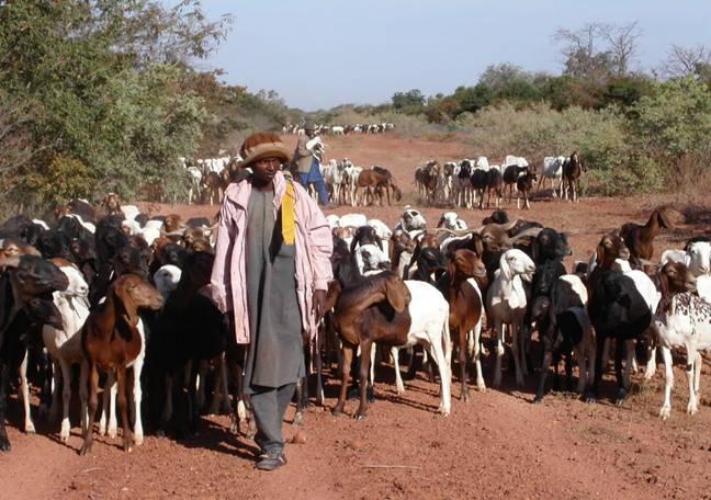
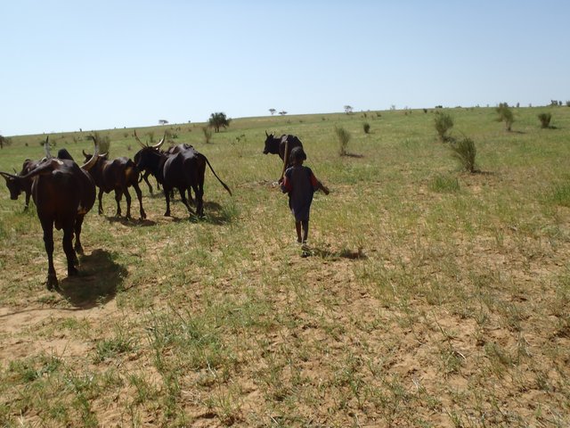
The ‘couloirs de passage’ are formally defined passageways which channel the movements of livestock herds in the agro-pastoral zones of Niger, by linking pastures, water points and coralling areas, be it within village areas (internal couloirs) or on open land (external couloirs).
2.2 ការពណ៌នាលម្អិតពីបច្ចេកទេស
ការពណ៌នា:
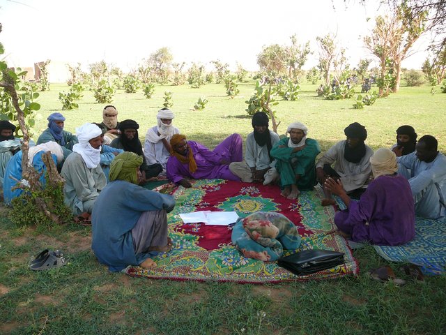
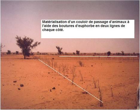
The main goal of the couloirs is the prevention of conflict between agriculturalists and pastoralists regarding the use of limited land and water resources. These conflicts are often provoked by cattle entering cropping areas. The establishment of demarcated passageways allows the livestock to access water points and pastures without causing damage to cropland. The corridors are regulated through the ‘code rural’ – a national law defining the land use rights of the pastoralists. Demarcation of couloirs is based on a consensual decision of all concerned interest groups. Internal couloirs are negotiated in a general on-site assembly involving all stakeholders (farmers, breeders, women’s groups, local authorities). For the demarcation of external couloirs the involvement of transhumance herders and neighboring villages is indispensable. Once an agreement on the course of the couloir is achieved, demarcation with stones and/or boundary planting with selected tree species is carried out by the local land users - with financial and technical assistance of the government or NGOs. Common species involve: Euphorbia balsamifera, Acacia spp. (A. nilotica; A. senegal); and Faidherbia albida. Management committees at the community level draw up regulations for the management of the couloirs (maintenance and protection of vegetation). Protection of plants is achieved through dead branches (at the initial stage), daily control by forest guards, and information campaigns. The technology is a sustainable solution to the described conflicts. As a valuable by-product the trees along the demarcation lines provide of wood and non-woody by-products.
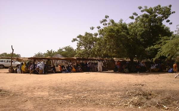
2.3 រូបភាពនៃបច្ចេកទេស
វិចិត្រសាលប្រព័ន្ធផ្សព្វផ្សាយ
2.5 ប្រទេស/តំបន់/ទីតាំងកន្លែង ដែលបច្ចេកទេសត្រូវបានអនុវត្ត និងបានគ្រប់ដណ្តប់ដោយការវាយតម្លៃនេះ
ប្រទេស:
ប្រទេសនីហ្សេ
តំបន់/រដ្ឋ/ខេត្ត:
Tillabéri North
បញ្ជាក់ពីការសាយភាយនៃបច្ចេកទេស:
- អនុវត្តនៅកន្លែងជាក់លាក់មួយ/ ប្រមូលផ្តុំនៅតំបន់តូចៗ
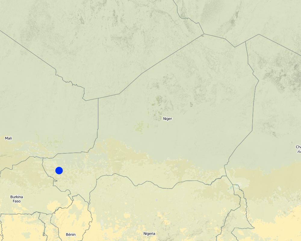
Map
×2.7 ការណែនាំពីបច្ចេកទេស
សូមបញ្ជាក់តើបច្ចេកទេសត្រូវបានណែនាំឱ្យអនុវត្តដោយរបៀបណា:
- តាមរយៈគម្រោង / អន្តរាគមន៍ពីខាងក្រៅ
3. ចំណាត់ថ្នាក់នៃបច្ចេកទេស SLM
3.1 គោលបំណងចម្បង (១ ឬច្រើន) នៃបច្ចេកទេសនេះ
- បង្កើតផលប្រយោជន៍សង្គម
3.2 ប្រភេទដីប្រើប្រាស់មួយប្រភេទ (ច្រើនប្រភេទ) ដែលបានអនុវត្តបច្ចេកទេស
ដីប្រើប្រាស់ចម្រុះនៅលើដីតែមួយ:
បាទ/ចា៎
បញ្ជាក់ពីប្រភេទដីច្រើនប្រភេទ (ដីដាំដំណាំ/ដីចិញ្ចឹមសត្វ/ដីព្រៃឈើ):
- ដីព្រៃឈើ និងដីចិញ្ចឹមសត្វ

ដីសម្រាប់ចិញ្ចឹមសត្វ
វាលស្មៅធំៗ:
- ពាក់កណ្តាលពនេចរ

ដីព្រៃ/ដីដាំដើមឈើ
មតិយោបល់:
Major land use problems (land users’ perception): Soil erosion by water, soil erosion by wind and biological degradation; Primary problem addressed is conflicts between livestock and agriculture producers around natural resources
Semi-nomadism / pastoralism: Yes
Future (final) land use (after implementation of SLM Technology): Mixed: Ms: Silvo-pastoralism
3.3 បន្ទាប់ពីអនុវត្តបច្ចេកទេស តើដីប្រើប្រាស់មានការប្រែប្រួលដែររឺទេ?
បន្ទាប់ពីអនុវត្តបច្ចេកទេស តើដីប្រើប្រាស់មានការប្រែប្រួលដែររឺទេ?
- បាទ/ច៎ា (សូមបំពេញសំណួរខាងក្រោមពីស្ថានភាពដីប្រើប្រាស់មុនពេលអនុវត្តបច្ចេកទេស)

ដីដាំដំណាំ
- ដំណាំប្រចាំឆ្នាំ
3.4 ការផ្គត់ផ្គង់ទឹក
ការផ្គត់ផ្គង់ទឹកនៅកន្លែងអនុវត្តបច្ចេកទេស:
- ទឹកភ្លៀង
3.5 ក្រុម SLM ដែលបច្ចេកទេសស្ថិតនៅក្នុង
- កសិរុក្ខកម្ម (pastoralism) និងការគ្រប់គ្រងដីសម្រាប់ចិញ្ចឹមសត្វ
3.6 វិធានការ SLM ដែលបញ្ចូលនូវបច្ចេកទេស

វិធានការរុក្ខជាតិ
- V1: ឈើធំៗ និងដើមឈើតូចៗ

វិធានការគ្រប់គ្រង
- M3: ប្លង់យោងទៅតាមធម្មជាតិ និងបរិស្ថានធម្មជាតិ
មតិយោបល់:
Type of vegetative measures: scattered / dispersed
3.7 កំណត់ប្រភេទនៃការធ្លាក់ចុះគុណភាពដីសំខាន់ៗដែលបច្ចេកទេសនេះបានដោះស្រាយ

ការហូរច្រោះដីដោយសារទឹក
- Wt: ការបាត់ដីស្រទាប់លើដោយការហូរច្រោះ

ការបាត់ដីដោយសារខ្យល់
- Et: ការបាត់បង់ដីស្រទាប់លើ

ការធ្លាក់ចុះជីវសាស្ត្រនៃដី
- Bc: ការថយចុះនូវគម្របរុក្ខជាតិ
មតិយោបល់:
Main type of degradation addressed: Wt: loss of topsoil / surface erosion, Et: loss of topsoil, Bc: reduction of vegetation cover
3.8 ការពារ កាត់បន្ថយ ឬស្តារឡើងវិញនៃការធ្លាក់ចុះគុណភាពដី
បញ្ជាក់ពីគោលដៅរបស់បច្ចេកទេស ដែលផ្តោតទៅការធ្លាក់ចុះគុណភាពដី:
- ការការពារការធ្លាក់ចុះគុណភាពដី
4. បច្ចេកទេសជាក់លាក់ សកម្មភាពអនុវត្ត ធាតុចូល និងថ្លៃដើម
4.1 គំនូសបច្ចេកទេសនៃបច្ចេកទេសនេះ
លក្ខណៈពិសេសនៃបច្ចេកទេស (ទាក់ទងនឺងគំនូរបច្ចេកទេស):
Technical knowledge required for field staff / advisors: high (facilitator of code rural)
Technical knowledge required for land users: low (pastors and workers)
Main technical functions: increase of biomass (quantity), promotion of vegetation species and varieties (quality, eg palatable fodder)
Trees/ shrubs species: Euphorbia balsamifera, Acacia spp. (A. nilotica; A. senegal) and Faidherbia albida
4.2 ព័ត៌មានទូទៅដែលពាក់ព័ន្ធនឹងការគណនាធាតុចូល និងថ្លៃដើម
កំណត់រូបិយប័ណ្ណសម្រាប់ថ្លៃដើម:
- ដុល្លារ
កំណត់ថ្លៃឈ្នួលជាមធ្យមនៃការជួលកម្លាំងពលកម្មក្នុងមួយថ្ងៃ:
1.5
4.3 សកម្មភាពបង្កើត
| សកម្មភាព | រយៈពេល (រដូវកាល) | |
|---|---|---|
| 1. | Identification of an existing couloir or definition of a new passageway by means of a general assembly | |
| 2. | Alignment of corridor boundaries e.g. by establishing stone lines. Internal couloirs are 10 to 50 m wide, whereas external couloirs exceed a width of 50 m | |
| 3. | Digging 40 cm deep pits; tree planting along boundaries (with a spacing of 1-3 meters, depending on the species selected and the secondary objective) |
4.4 ថ្លៃដើម និងធាតុចូលដែលត្រូវការសម្រាប់ការបង្កើតបច្ចេកទេស
| បញ្ជាក់ពីធាតុចូល | ឯកតា | បរិមាណ | ថ្លៃដើមក្នុងមួយឯកតា | ថ្លៃធាតុចូលសរុប | % នៃថ្លៃដើមដែលចំណាយដោយអ្នកប្រើប្រាស់ដី | |
|---|---|---|---|---|---|---|
| កម្លាំងពលកម្ម | Identification of an existing couloir or definition of a new passageway | persons/day | 25,0 | 1,5 | 37,5 | 5,0 |
| សម្ភារៈដាំដុះ | Tree planting along boundaries (seedlings) | pieces | 670,0 | 2,05 | 1373,5 | 5,0 |
| ថ្លៃដើមសរុបក្នុងការបង្កើតបច្ចេកទេស | 1411,0 | |||||
| ថ្លៃដើមសរុបក្នុងការបង្កើតបច្ចេកទេសគិតជាដុល្លារ | 1411,0 | |||||
ប្រសិនបើអ្នកប្រើប្រាស់ដីមិនមានថ្លៃដើម 100% សូមបញ្ជាក់ថានរណាដែលចំណាយថ្លៃដើមដែលនៅសល់:
Government or NGO's
4.5 សកម្មភាពថែទាំ
| សកម្មភាព | ពេលវេលា/ ភាពញឹកញាប់ | |
|---|---|---|
| 1. | Protection of trees (through dead branches, guards, information campaigns) | |
| 2. | Replanting tree seedlings to fill gaps (annually, beginning of rainy season) |
4.6 កំណត់ថ្លៃដើមសម្រាប់ការថែទាំ/ សកម្មភាពរបស់បច្ចេកទេស (ក្នុងរយៈពេលមួយឆ្នាំ)
| បញ្ជាក់ពីធាតុចូល | ឯកតា | បរិមាណ | ថ្លៃដើមក្នុងមួយឯកតា | ថ្លៃធាតុចូលសរុប | % នៃថ្លៃដើមដែលចំណាយដោយអ្នកប្រើប្រាស់ដី | |
|---|---|---|---|---|---|---|
| កម្លាំងពលកម្ម | Protection of trees | persons/day | 4,0 | 1,5 | 6,0 | 100,0 |
| សម្ភារៈដាំដុះ | Replanting tree seedlings | pieces | 67,0 | 2,0448 | 137,0 | 100,0 |
| ថ្លៃដើមសរុបសម្រាប់ការថែទាំដំណាំតាមបច្ចេកទេស | 143,0 | |||||
| ថ្លៃដើមសរុបសម្រាប់ការថែទាំដំណាំតាមបច្ចេកទេសគិតជាដុល្លារ | 143,0 | |||||
មតិយោបល់:
Costs for seedlings were calculated for a couloir length of 1 km and a spacing of 3 m between plants (one tree line on each side). Seedling production is financed by projects, only transport costs are met by land users.
4.7 កត្តាសំខាន់បំផុតដែលមានឥទ្ធិពលដល់ការចំណាយ
ពណ៌នាពីកត្តាប៉ះពាល់ចម្បងៗទៅលើថ្លៃដើម:
The costs of the planning meeting (general assembly) and the stones for delimitation were not taken into account. Daily salary for field work is US$ 1.5.
5. លក្ខណៈបរិស្ថានធម្មជាតិ និងមនុស្ស
5.1 អាកាសធាតុ
បរិមាណទឹកភ្លៀងប្រចាំឆ្នាំ
- < 250 មម
- 251-500 មម
- 501-750 មម
- 751-1,000 មម
- 1,001-1,500 មម
- 1,501-2,000 មម
- 2,001-3,000 មម
- 3,001-4,000 មម
- > 4,000 មម
តំបន់កសិអាកាសធាតុ
- មានភ្លៀងតិចតួច
Thermal climate class: tropics
5.2 សណ្ឋានដី
ជម្រាលជាមធ្យម:
- រាបស្មើ (0-2%)
- ជម្រាលតិចតួច (3-5%)
- មធ្យម (6-10%)
- ជម្រាលខ្ពស់បន្តិច (11-15%)
- ទីទួល (16-30%)
- ទីទួលចោត (31-60%)
- ទីទួលចោតខ្លាំង (>60%)
ទម្រង់ដី:
- ខ្ពង់រាប
- កំពូលភ្នំ
- ជម្រាលភ្នំ
- ជម្រាលទួល
- ជម្រាលជើងភ្នំ
- បាតជ្រលងភ្នំ
តំបន់តាមរយៈកម្ពស់ :
- 0-100 ម
- 101-500 ម
- 501-1,000 ម
- 1,001-1,500 ម
- 1,501-2,000 ម
- 2,001-2,500 ម
- 2,501-3,000 ម
- 3,001-4,000 ម
- > 4,000 ម
5.3 ដី
ជម្រៅដីជាមធ្យម:
- រាក់ខ្លាំង (0-20 សម)
- រាក់ (21-50 សម)
- មធ្យម (51-80 សម)
- ជ្រៅ (81-120 សម)
- ជ្រៅខ្លាំង (> 120 សម)
វាយនភាពដី (ស្រទាប់លើ):
- គ្រើម/ មានពន្លឺ (ខ្សាច់)
សារធាតុសរីរាង្គនៅស្រទាប់ដីខាងលើ:
- ទាប (<1%)
បើអាចសូមភ្ជាប់ការពណ៌នាពីដីឱ្យបានច្បាស់ ឬព័ត៌មានដែលអាចទទួលបាន ឧ. ប្រភេទដី, pH ដី/ ជាតិអាស៊ីត, សមត្ថភាពផ្លាស់ប្តូរកាចុង, វត្តមាននីត្រូសែន, ភាពប្រៃ ។ល។:
Soil fertility is medium
Soil drainage / infiltration is good but low in case of soil crusting
5.6 លក្ខណៈនៃអ្នកប្រើប្រាស់ដីដែលអនុវត្តបច្ចេកទេស
ទីផ្សារនៃប្រព័ន្ធផលិតកម្ម:
- សម្រាប់ហូបក្នុងគ្រួសារ (ផ្គត់ផ្គង់ខ្លួនឯង)
- ពាក់កណ្តាលពាណិជ្ជកម្ម (ផ្គត់ផ្គង់ខ្លួនឯង/ ពាណិជ្ជកម្ម)
ឯកជន ឬក្រុម:
- ជាក្រុម/ សហគមន៍
កម្រិតប្រើប្រាស់គ្រឿងយន្ត:
- ប្រើកម្លាំងសត្វ
សូមបញ្ជាក់ពីលក្ខណៈពាក់ព័ន្ធផ្សេងទៀតអំពីអ្នកប្រើប្រាស់ដី:
Population density: 10-50 persons/km2
5.7 ទំហំផ្ទៃដីជាមធ្យមនៃដីប្រើប្រាស់ដោយអ្នកប្រើប្រាស់ដី ក្នុងការអនុវត្តបច្ចេកទេស
- < 0.5 ហិកតា
- 0.5-1 ហិកតា
- 1-2 ហិកតា
- 2-5 ហិកតា
- 5-15 ហិកតា
- 15-50 ហិកតា
- 50-100 ហិកតា
- 100-500 ហិកតា
- 500-1,000 ហិកតា
- 1,000-10,000 ហិកតា
- > 10,000 ហិកតា
5.8 ភាពជាម្ចាស់ដី កម្មសិទ្ធប្រើប្រាស់ដី និងកម្មសិទ្ធប្រើប្រាស់ទឹក
ភាពជាម្ចាស់ដី:
- ឯកជន មានកម្មសិទ្ធ
កម្មសិទ្ធិប្រើប្រាស់ដី:
- ជាក្រុម (មានដែនកំណត់)
- ឯកជន
6. ផលប៉ះពាល់ និងការសន្និដ្ឋាន
6.1 ផលប៉ះពាល់ក្នុងបរិវេណអនុវត្តបច្ចេកទេសដែលកើតមាន
ផលប៉ះពាល់លើសេដ្ឋកិច្ចសង្គម
ផលិតផល
ផលិតកម្មដំណាំ
ផលិតកម្មចំណីសត្វ
គុណភាពចំណីសត្វ
ផលិតកម្មសត្វ
ចំណូល និងថ្លៃដើម
ចំណូលក្នុងកសិដ្ឋាន
ផលប៉ះពាល់ទៅលើវប្បធម៌សង្គម
ឱកាសវប្បធម៍
ស្ថាប័នសហគមន៍
មតិយោបល់/ ការបញ្ជាក់:
Through mutual aid in technology implementation
ស្ថាប័នជាតិ
មតិយោបល់/ ការបញ្ជាក់:
Code rural secretariat
ចំណេះដឹង SLM / ការធ្លាក់ចុះគុណភាពដី
ផលប៉ះពាល់ទៅលើអេកូឡូស៊ី
ដី
គម្របដី
ការបាត់បង់ដី
វដ្តនៃសារធាតុចិញ្ចឹម/ការទទួលបាន
ជីវចម្រុះ៖ ដំណាំ, សត្វ
ជីវម៉ាស/ កាបូនលើដី
ភាពសម្បូរបែបនៃសត្វ
ការកាត់បន្ថយហានិភ័យនៃគ្រោះមហន្តរាយ និងគ្រោះអាកាសធាតុ
ហានិភ័យនៃភ្លើងឆេះព្រៃ
ល្បឿនខ្យល់
6.2 ផលប៉ះពាល់ក្រៅបរិវេណអនុវត្តបច្ចេកទេសដែលកើតមាន
ខ្យល់នាំយកនូវធូរលី
ខូចខាតដល់ស្រែអ្នកជិតខាង
ខូចខាតដល់ហេដ្ឋារចនាសម្ព័ន្ធសាធារណៈ/ឯកជន
6.3 ភាពប្រឈម និងភាពរួសនៃបច្ចេកទេសទៅនឹងការប្រែប្រួលអាកាសធាតុ និងគ្រោះអាកាសធាតុ/ គ្រោះមហន្តរាយ (ដែលដឹងដោយអ្នកប្រើប្រាស់ដី)
មតិយោបល់:
Technology is sensitive to climatic extremes (such as droughts and floods)
6.4 ការវិភាគថ្លៃដើម និងអត្ថប្រយោជន៍
តើផលចំណេញ និងថ្លៃដើមត្រូវបានប្រៀបធៀបគ្នាយ៉ាងដូចម្តេច (ទស្សនៈរបស់អ្នកប្រើប្រាស់ដី)?
រយៈពេលខ្លី:
វិជ្ជមាន
រយៈពេលវែង:
វិជ្ជមានខ្លាំង
តើផលចំណេញ និងការថែទាំ/ ជួសជុលត្រូវបានប្រៀបធៀបគ្នាយ៉ាងដូចម្តេច (ទស្សនៈរបស់អ្នកប្រើប្រាស់ដី)?
រយៈពេលខ្លី:
វិជ្ជមាន
រយៈពេលវែង:
វិជ្ជមានខ្លាំង
មតិយោបល់:
Peace between communities is the key result on short term and on long term. Ecological and economic benefits are linked to the plantation of trees and the improved management of natural resources
6.5 ការទទួលយកបច្ចេកទេស
ក្នុងចំណោមគ្រួសារទាំងអស់ដែលបានអនុវត្តបច្ចេកទេស តើមានប៉ុន្មានគ្រួសារដែលចង់ធ្វើដោយខ្លួនឯង ដោយមិនទទួលបានសម្ភារៈលើកទឹកចិត្ត/ប្រាក់ឧបត្ថម្ភ?:
- 0-10%
មតិយោបល់:
There is a strong trend towards spontaneous adoption of the Technology
Comments on adoption trend: for prevention of conflicts and land degradation
6.7 ភាពខ្លាំង/ គុណសម្បត្តិ/ ឱកាសនៃបច្ចេកទេស
| ភាពខ្លាំង/ គុណសម្បត្តិ/ ឱកាស ទស្សនៈរបស់បុគ្គលសំខាន់ៗ |
|---|
| The technology provides a sustainable solution to conflicts between agriculturalists and pastoralists |
6.8 ភាពខ្សោយ/ គុណវិបត្តិ/ ហានិភ័យនៃបច្ចេកទេស និងវិធីសាស្ត្រដោះស្រាយ
| ភាពខ្សោយ/ គុណវិបត្តិ/ ហានិភ័យ ទស្សនៈរបស់អ្នកប្រើប្រាស់ដី | តើបច្ចេកទេសទាំងនោះបានដោះស្រាយបញ្ហាដូចម្តេច? |
|---|---|
| Implementation constraints: plant production is very expensive and reaching a consensus on the transformation of private cropland to communal passageways is very difficult | definition of the couloirs as public infrastructure and enhancement of organizational capacities of the local population through training and information sessions |
| Maintenance constraints: maintenance can only be realized by adjacent land owners, as the community organizations are weak | reinforce the institutional capacities of livestock owners and farmers to manage the couloirs |
| In the pastoral zone the couloirs lead to conflicts between pastoralists and private ranches | establish community-based land tenure commissions and introduce new laws on land property in the pastoral zone |
7. ឯកសារយោង និងវេបសាយ
7.2 ឯកសារយោងដែលបានចេញផ្សាយ
ចំណងជើង អ្នកនិពន្ធ ឆ្នាំ ISBN:
Projet LUCOP/Tillabéry. 2004. Referential des measures techniques de recuperation, de protection et d’exploitation durable des terres, 2nd edition, 2004, 51 pp
ចំណងជើង អ្នកនិពន្ធ ឆ្នាំ ISBN:
Hiernaux P., E. Tielkes, E. Schlecht. 2001. Elevage et gestion des parcours au Sahel, Workshop proceedings organised by Eric Tielkes et Abdoulaye Soumaila, Verlag Ulrich E. Grauer, Beuren, Stuttgart, Germany, 2001
7.3 ការភ្ជាប់ទៅកាន់ព័ត៌មានពាក់ព័ន្ធលើប្រព័ន្ធអនឡាញ
ចំណងជើង/ ពណ៌នា:
Soumaila A.S. 2003. Base de données du code rural
វេបសាយ:
www.case.ibimet.cnr.it/den/Documents/code_rural/start.html
ការតភ្ជាប់ និងម៉ូឌុល
ពង្រីកមើលទាំងអស់ បង្រួមទាំងអស់ការតភ្ជាប់
Pastoralisme au Niger : Système de suivi des … [ប្រទេសនីហ្សេ]
Cette approche traditionnelle initialement, soutenue par le Dispositif National de Prévention et de Gestion des Catastrophes et des Crises Alimentaires (DNPGCCA), se présente sous la forme d’un Système d'Information Géographique (SIG) intégrant les ressources hydrauliques, le mouvement des populations et la répartition spatiale et quantitative des pâturages. L’objectif de l’approche …
- អ្នកចងក្រង៖ Soumaila Abdoulaye
Champ Ecole Pastorale [ប្រទេសនីហ្សេ]
Le Champ Ecole (CE) Pastorale, une école «sans murs», est un cadre de rencontre et de formation pour un groupe de 20 à 30 éleveurs de la zone pastorale du Niger, qui se déroule sur une aire de pâturage communautaire, tout au long de l'année. C’est un lieu d’échange d’expériences …
- អ្នកចងក្រង៖ Soumaila Abdoulaye
ម៉ូឌុល
គ្មានម៉ូឌុល