Couloirs de passage [ໄນເຈີ]
- ການສ້າງ:
- ປັບປູງ:
- ຜູ້ສັງລວມຂໍ້ມູນ: Lemma Ababu
- ບັນນາທິການ: –
- ຜູ້ທົບທວນຄືນ: Alexandra Gavilano
technologies_1353 - ໄນເຈີ
ເບິ່ງພາກສ່ວນ
ຂະຫຍາຍທັງໝົດ ຍຸບທັງໝົດ1. ຂໍ້ມູນທົ່ວໄປ
1.2 ຂໍ້ມູນ ການຕິດຕໍ່ພົວພັນ ຂອງບຸກຄົນທີ່ສໍາຄັນ ແລະ ສະຖາບັນ ທີ່ມີສ່ວນຮ່ວມ ໃນການປະເມີນເອກກະສານ ເຕັກໂນໂລຢີ
ຊື່ສະຖາບັນ (ຫຼາຍສະຖາບັນ) ທີ່ອໍານວຍຄວາມສະດວກ ໃນການສ້າງເອກກະສານ / ປະເມີນ ເຕັກໂນໂລຢີ (ຖ້າກ່ຽວຂ້ອງ)
GREAD (GREAD) - ໄນເຈີ1.3 ເງື່ອນໄຂ ກ່ຽວກັບ ການນໍາໃຊ້ຂໍ້ມູນເອກະສານ ທີ່ສ້າງຂື້ນ ໂດຍຜ່ານ ອົງການພາບລວມຂອງໂລກ ທາງດ້ານແນວທາງ ແລະ ເຕັກໂນໂລຢີ ຂອງການອານຸລັກ ທໍາມະຊາດ (WOCAT)
ຜູ້ປ້ອນຂໍ້ມູນ ແລະ ບຸກຄົນສຳຄັນ ທີ່ໃຫ້ຂໍ້ມູນ (ຫຼາຍ) ຍິນຍອມ ຕາມເງື່ອນໄຂ ໃນການນຳໃຊ້ຂໍ້ມູນ ເພື່ອສ້າງເປັນເອກກະສານຂອງ WOCAT:
ແມ່ນ
1.5 ແບບສອບຖາມທີ່ອ້າງອີງເຖີງແນວທາງ ການຄຸ້ມຄອງທີ່ດິນແບບຍືນຍົງ (ໄດ້ເຮັດເປັນເອກະສານທີ່ໃຊ້ WOCAT)
Pastoralisme au Niger : Système de suivi des … [ໄນເຈີ]
Cette approche traditionnelle initialement, soutenue par le Dispositif National de Prévention et de Gestion des Catastrophes et des Crises Alimentaires (DNPGCCA), se présente sous la forme d’un Système d'Information Géographique (SIG) intégrant les ressources hydrauliques, le mouvement des populations et la répartition spatiale et quantitative des pâturages. L’objectif de l’approche …
- ຜູ້ສັງລວມຂໍ້ມູນ: Soumaila Abdoulaye
Champ Ecole Pastorale [ໄນເຈີ]
Le Champ Ecole (CE) Pastorale, une école «sans murs», est un cadre de rencontre et de formation pour un groupe de 20 à 30 éleveurs de la zone pastorale du Niger, qui se déroule sur une aire de pâturage communautaire, tout au long de l'année. C’est un lieu d’échange d’expériences …
- ຜູ້ສັງລວມຂໍ້ມູນ: Soumaila Abdoulaye
2. ການອະທິບາຍ ເຕັກໂນໂລຢີ ຂອງການຄຸ້ມຄອງ ທີ່ດິນແບບຍືນຍົງ
2.1 ຄໍາອະທິບາຍສັ້ນຂອງ ເຕັກໂນໂລຢີ
ການກຳໜົດຄວາມໝາຍ ຂອງເຕັກໂນໂລຢີ:
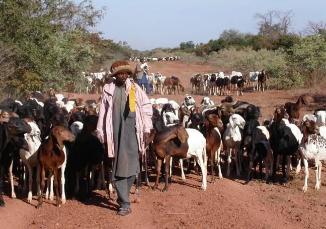
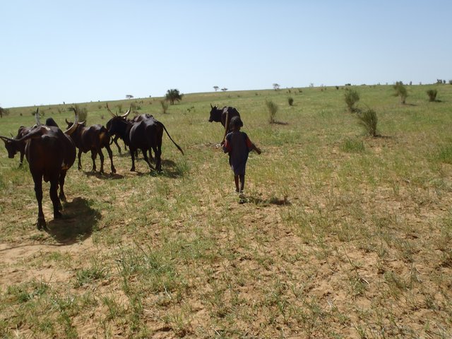
The ‘couloirs de passage’ are formally defined passageways which channel the movements of livestock herds in the agro-pastoral zones of Niger, by linking pastures, water points and coralling areas, be it within village areas (internal couloirs) or on open land (external couloirs).
2.2 ການອະທິບາຍ ລາຍລະອຽດ ຂອງເຕັກໂນໂລຢີ
ການພັນລະນາ:
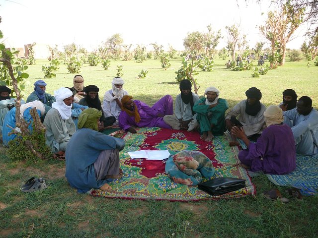
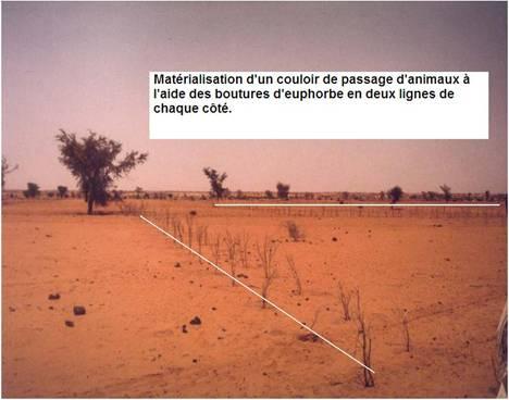
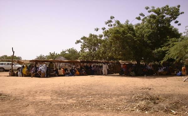
The main goal of the couloirs is the prevention of conflict between agriculturalists and pastoralists regarding the use of limited land and water resources. These conflicts are often provoked by cattle entering cropping areas. The establishment of demarcated passageways allows the livestock to access water points and pastures without causing damage to cropland. The corridors are regulated through the ‘code rural’ – a national law defining the land use rights of the pastoralists. Demarcation of couloirs is based on a consensual decision of all concerned interest groups. Internal couloirs are negotiated in a general on-site assembly involving all stakeholders (farmers, breeders, women’s groups, local authorities). For the demarcation of external couloirs the involvement of transhumance herders and neighboring villages is indispensable. Once an agreement on the course of the couloir is achieved, demarcation with stones and/or boundary planting with selected tree species is carried out by the local land users - with financial and technical assistance of the government or NGOs. Common species involve: Euphorbia balsamifera, Acacia spp. (A. nilotica; A. senegal); and Faidherbia albida. Management committees at the community level draw up regulations for the management of the couloirs (maintenance and protection of vegetation). Protection of plants is achieved through dead branches (at the initial stage), daily control by forest guards, and information campaigns. The technology is a sustainable solution to the described conflicts. As a valuable by-product the trees along the demarcation lines provide of wood and non-woody by-products.
2.3 ຮູບພາບຂອງເຕັກໂນໂລຢີ
ສື່ຮູບພາບ
2.5 ປະເທດ / ເຂດ / ສະຖານທີ່ບ່ອນທີ່ ເຕັກໂນໂລຢີ ໄດ້ຮັບການນໍາໃຊ້ ແລະ ທີ່ຖືກປົກຄຸມດ້ວຍການປະເມີນຜົນ
ປະເທດ:
ໄນເຈີ
ພາກພື້ນ / ລັດ / ແຂວງ:
Tillabéri North
ໃຫ້ລະບຸ ການແຜ່ຂະຫຍາຍ ເຕັກໂນໂລຢີ:
- ນໍາໃຊ້ໃນຈຸດສະເພາະ / ແນໃສ່ນໍາໃຊ້ໃນພື້ນທີ່ຂະໜາດນ້ອຍ
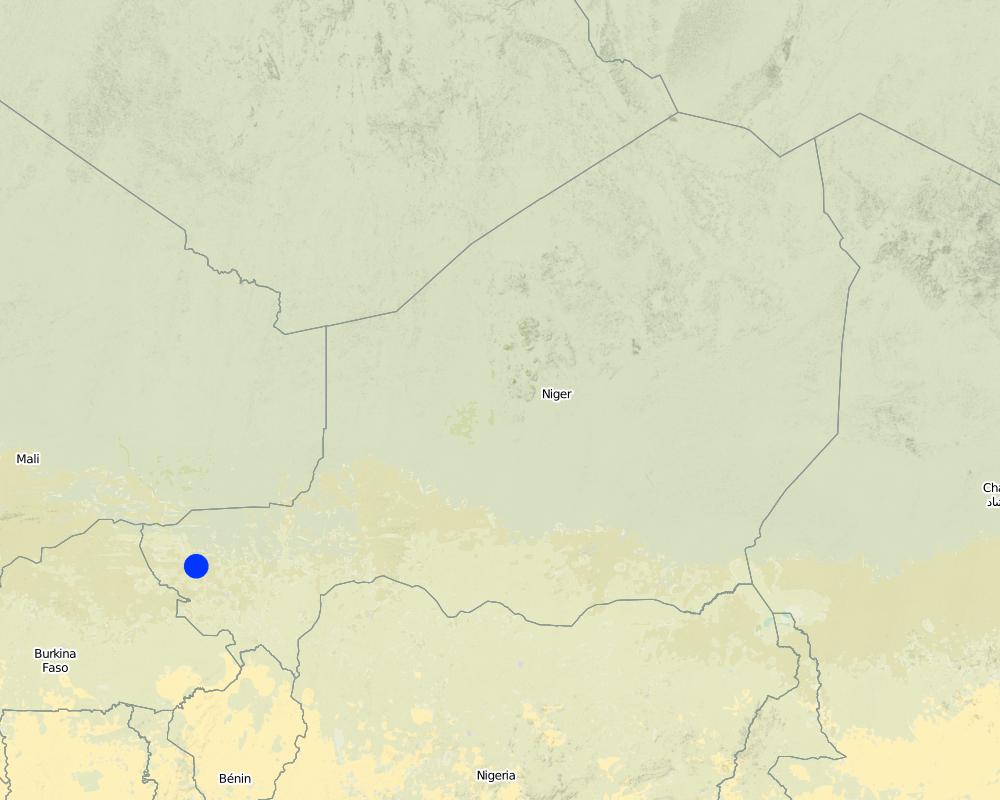
Map
×2.7 ການນໍາສະເໜີ ເຕັກໂນໂລຢີ
ໃຫ້ລະບຸ ເຕັກໂນໂລຢີ ໄດ້ຖືກຈັດຕັ້ງປະຕິບັດຄືແນວໃດ?
- ໂດຍຜ່ານໂຄງການ / ການຊ່ວຍເຫຼືອຈາກພາຍນອກ
3. ການໃຈ້ແຍກ ເຕັກໂນໂລຢີ ໃນການຄຸ້ມຄອງ ດິນແບບຍືນຍົງ
3.1 ຈຸດປະສົງຫຼັກ (ຫຼາຍ) ຂອງເຕັກໂນໂລຢີ
- ສ້າງຜົນກະທົບ ທີ່ເປັນທາງບວກ ໃຫ້ແກ່ສັງຄົມ
3.2 ປະເພດການນໍາໃຊ້ທີ່ດິນ ໃນປະຈຸບັນ() ທີ່ເຕັກໂນໂລຢີ ໄດ້ຖືກນໍາໃຊ້
ການນຳໃຊ້ທີ່ດິນ ປະສົມພາຍໃນພື້ນທີ່ດຽວກັນ:
ແມ່ນ
ລະບຸການນຳໃຊ້ທີ່ດິນແບບປະສົມ (ຜົນລະປູກ / ທົ່ງຫຍ້າລ້ຽງສັດ / ຕົ້ນໄມ້):
- ປ່າໄມ້-ທົ່ງຫຍ້າ

ທົ່ງຫຍ້າລ້ຽງສັດ
ການລ້ຽງສັດແບບປ່ອຍ ຕາມທຳມະຊາດ:
- ການລ້ຽງສັດແບບເຄີ່ງປ່ອຍ

ປ່າໄມ້ / ປ່າ
ຄວາມຄິດເຫັນ:
Major land use problems (land users’ perception): Soil erosion by water, soil erosion by wind and biological degradation; Primary problem addressed is conflicts between livestock and agriculture producers around natural resources
Semi-nomadism / pastoralism: Yes
Future (final) land use (after implementation of SLM Technology): Mixed: Ms: Silvo-pastoralism
3.3 ການນຳໃຊ້ທີ່ດິນ ມີການປ່ຽນແປງຍ້ອນການຈັດຕັ້ງທົດລອງເຕັກໂນໂລຢີ ແມ່ນບໍ່?
ການນຳໃຊ້ທີ່ດິນ ມີການປ່ຽນແປງຍ້ອນການຈັດຕັ້ງທົດລອງເຕັກໂນໂລຢີ ແມ່ນບໍ່?
- ແມ່ນ (ກະລຸນາຕື່ມໃສ່ ຄຳຖາມຂ້າງລຸ່ມນີ້ກ່ຽວກັບການນຳໃຊ້ທີ່ດິນ ກ່ອນການທົດລອງເຕັກໂນໂລຢີ)

ດິນທີ່ປູກພືດ
- ການປູກພືດປະຈໍາປີ
3.4 ການສະໜອງນ້ຳ
ການສະໜອງນໍ້າ ໃນພື້ນທີ່ ທີ່ໄດ້ນໍາໃຊ້ ເຕັກໂນໂລຢີ:
- ນໍ້າຝົນ
3.5 ການນໍາໃຊ້ເຕັກໂນໂລຢີ ທີ່ຢູ່ໃນກຸ່ມການຄຸ້ມຄອງ ທີ່ດິນແບບຍືນຍົງ
- ການຄຸ້ມຄອງສັດລ້ຽງ ແລະ ທົ່ງຫຍ້າລ້ຽງສັດ
3.6 ມາດຕະການ ການຄຸ້ມຄອງ ທີ່ດິນແບບຍືນຍົງ ປະກອບດ້ວຍ ເຕັກໂນໂລຢີ

ມາດຕະການ ທາງດ້ານພືດພັນ
- V1: ເປັນໄມ້ຢືນຕົ້ນ ແລະ ການປົກຫຸ້ມຂອງໄມ້ພຸ່ມ

ມາດຕະການ ທາງດ້ານການຄຸ້ມຄອງ
- M3: ອີງຕາມສະພາບແວດລ້ອມ ທາງທຳມະຊາດ ແລະ ມະນຸດ
ຄວາມຄິດເຫັນ:
Type of vegetative measures: scattered / dispersed
3.7 ປະເພດດິນເຊື່ອມໂຊມ ຫຼັກທີ່ໄດ້ນໍາໃຊ້ ເຕັກໂນໂລຢີ

ດິນເຊາະເຈື່ອນ ໂດຍນໍ້າ
- Wt: ການສູນເສຍຊັ້ນໜ້າດິນ / ການເຊາະເຈື່ອນຜິວໜ້າດິນ

ດິນເຊາະເຈື່ອນ ໂດຍລົມ
- ການສູນເສຍຊັ້ນໜ້າດິນ

ການເຊື່ອມໂຊມ ທາງຊີວະພາບ
- Bc: ການຫຼຸດຜ່ອນການປົກຫຸ້ມຂອງພືດ
ຄວາມຄິດເຫັນ:
Main type of degradation addressed: Wt: loss of topsoil / surface erosion, Et: loss of topsoil, Bc: reduction of vegetation cover
3.8 ການປ້ອງກັນ, ການຫຼຸດຜ່ອນ, ຫຼືການຟື້ນຟູຂອງການເຊື່ອມໂຊມຂອງດິນ
ໃຫ້ລະບຸ ເປົ້າໝາຍ ເຕັກໂນໂລຢີ ທີ່ພົວພັນ ກັບຄວາມເຊື່ອມໂຊມຂອງດິນ:
- ປ້ອງກັນການເຊື່ອມໂຊມຂອງດິນ
4. ຂໍ້ກໍາໜົດ, ກິດຈະກໍາການປະຕິບັດ, ວັດຖຸດິບ, ແລະຄ່າໃຊ້ຈ່າຍ
4.1 ເຕັກນິກ ໃນການແຕ້ມແຜນວາດ ເຕັກໂນໂລຢີ
ຄຸນລັກສະນະ ຂອງເຕັກນິກ (ທີ່ກ່ຽວຂ້ອງ ກັບການແຕ້ມແຜນວາດ ທາງດ້ານເຕັກນີກ):
Technical knowledge required for field staff / advisors: high (facilitator of code rural)
Technical knowledge required for land users: low (pastors and workers)
Main technical functions: increase of biomass (quantity), promotion of vegetation species and varieties (quality, eg palatable fodder)
Trees/ shrubs species: Euphorbia balsamifera, Acacia spp. (A. nilotica; A. senegal) and Faidherbia albida
4.2 ຂໍ້ມູນທົ່ວໄປກ່ຽວກັບການຄິດໄລ່ປັດໃຈຂາເຂົ້າໃນການຜະລິດ ແລະ ມູນຄ່າອື່ນໆ
ລະບຸ ສະກຸນເງິນທີ່ໃຊ້ສໍາລັບ ການຄິດໄລ່ຄ່າໃຊ້ຈ່າຍ:
- USA
ລະບຸ ຄ່າຈ້າງ ຄ່າແຮງງານສະເລ່ຍ ຕໍ່ ວັນ:
1.5
4.3 ການສ້າງຕັ້ງກິດຈະກໍາ
| ກິດຈະກໍາ | Timing (season) | |
|---|---|---|
| 1. | Identification of an existing couloir or definition of a new passageway by means of a general assembly | |
| 2. | Alignment of corridor boundaries e.g. by establishing stone lines. Internal couloirs are 10 to 50 m wide, whereas external couloirs exceed a width of 50 m | |
| 3. | Digging 40 cm deep pits; tree planting along boundaries (with a spacing of 1-3 meters, depending on the species selected and the secondary objective) |
4.4 ຕົ້ນທຶນ ແລະ ປັດໄຈຂາເຂົ້າທີ່ຈໍາເປັນໃນຈັດຕັ້ງປະຕິບັດ
| ລະບຸ ປັດໃຈ ນໍາເຂົ້າ ໃນການຜະລີດ | ຫົວໜ່ວຍ | ປະລິມານ | ຕົ້ນທຶນ ຕໍ່ຫົວໜ່ວຍ | ຕົ້ນທຶນທັງໝົດ ຂອງປັດໃຈຂາເຂົ້າ ໃນການຜະລິດ | % ຂອງຕົ້ນທຶນທັງໝົດ ທີ່ຜູ້ນໍາໃຊ້ທີ່ດິນ ໃຊ້ຈ່າຍເອງ | |
|---|---|---|---|---|---|---|
| ແຮງງານ | Identification of an existing couloir or definition of a new passageway | persons/day | 25.0 | 1.5 | 37.5 | 5.0 |
| ວັດສະດຸໃນການປູກ | Tree planting along boundaries (seedlings) | pieces | 670.0 | 2.05 | 1373.5 | 5.0 |
| ຕົ້ນທຶນທັງໝົດ ໃນການຈັດຕັ້ງປະຕິບັດ ເຕັກໂນໂລຢີ | 1411.0 | |||||
| ຄ່າໃຊ້ຈ່າຍທັງໝົດ ສຳລັບການສ້າງຕັ້ງເຕັກໂນໂລຢີ ເປັນສະກຸນເງີນໂດລາ | 1411.0 | |||||
ຖ້າຫາກຜູ້ນຳໃຊ້ທີ່ດິນ ນຳໃຊ້ມູນຄ່າຕ່ຳກວ່າ 100% ໃຫ້ລະບຸ ແມ່ນໃຜເປັນຜູ້ຊ່ວຍ ໃນລາຍຈ່າຍທີ່ເຫຼືອ:
Government or NGO's
4.5 ບໍາລຸງຮັກສາ / ແຜນຈັດຕັ້ງປະຕິບັດ ກິດຈະກໍາ
| ກິດຈະກໍາ | ໄລຍະເວລາ / ຄວາມຖີ່ | |
|---|---|---|
| 1. | Protection of trees (through dead branches, guards, information campaigns) | |
| 2. | Replanting tree seedlings to fill gaps (annually, beginning of rainy season) |
4.6 ຄ່າໃຊ້ຈ່າຍ ແລະ ປັດໄຈນໍາເຂົ້າທີ່ຈໍາເປັນສໍາລັບການບໍາລຸງຮັກສາກິດຈະກໍາ / ແຜນປະຕິບັດ (ຕໍ່ປີ)
| ລະບຸ ປັດໃຈ ນໍາເຂົ້າ ໃນການຜະລີດ | ຫົວໜ່ວຍ | ປະລິມານ | ຕົ້ນທຶນ ຕໍ່ຫົວໜ່ວຍ | ຕົ້ນທຶນທັງໝົດ ຂອງປັດໃຈຂາເຂົ້າ ໃນການຜະລິດ | % ຂອງຕົ້ນທຶນທັງໝົດ ທີ່ຜູ້ນໍາໃຊ້ທີ່ດິນ ໃຊ້ຈ່າຍເອງ | |
|---|---|---|---|---|---|---|
| ແຮງງານ | Protection of trees | persons/day | 4.0 | 1.5 | 6.0 | 100.0 |
| ວັດສະດຸໃນການປູກ | Replanting tree seedlings | pieces | 67.0 | 2.0448 | 137.0 | 100.0 |
| ຕົ້ນທຶນທັງໝົດ ທີ່ໃຊ້ໃນການບໍາລຸງຮັກສາ ເຕັກໂນໂລຢີ | 143.0 | |||||
| ຄ່າໃຊ້ຈ່າຍທັງໝົດ ສຳລັບການບົວລະບັດຮກສາເຕັກໂນໂລຢີ ເປັນສະກຸນເງີນໂດລາ | 143.0 | |||||
ຄວາມຄິດເຫັນ:
Costs for seedlings were calculated for a couloir length of 1 km and a spacing of 3 m between plants (one tree line on each side). Seedling production is financed by projects, only transport costs are met by land users.
4.7 ປັດໄຈ ທີ່ສໍາຄັນ ທີ່ສົ່ງຜົນກະທົບ ຕໍ່ຄ່າໃຊ້ຈ່າຍ
ໃຫ້ອະທິບາຍ ປັດໃຈ ທີ່ສົ່ງຜົນກະທົບ ຕໍ່ຕົ້ນທຶນ ໃນການຈັດຕັ້ງປະຕິບັດ:
The costs of the planning meeting (general assembly) and the stones for delimitation were not taken into account. Daily salary for field work is US$ 1.5.
5. ສະພາບແວດລ້ອມທໍາມະຊາດ ແລະ ມະນຸດ
5.1 ອາກາດ
ປະລິມານນໍ້າຝົນປະຈໍາປີ
- < 250 ມີລິແມັດ
- 251-500 ມີລິແມັດ
- 501-750 ມີລິແມັດ
- 751-1,000 ມີລິແມັດ
- 1,001-1,500 ມີລິແມັດ
- 1,501-2,000 ມີລິແມັດ
- 2,001-3,000 ມີລິແມັດ
- 3,001-4,000 ມີລິແມັດ
- > 4,000 ມີລິແມັດ
ເຂດສະພາບອາກາດກະສິກໍາ
- ເຄິ່ງແຫ້ງແລ້ງ
Thermal climate class: tropics
5.2 ພູມິປະເທດ
ຄ່າສະເລ່ຍ ຄວາມຄ້ອຍຊັນ:
- ພື້ນທີ່ຮາບພຽງ (0-2%)
- ອ່ອນ (3-5 %)
- ປານກາງ (6-10 %)
- ມ້ວນ (11-15 %)
- ເນີນ(16-30%)
- ໍຊັນ (31-60%)
- ຊັນຫຼາຍ (>60%)
ຮູບແບບຂອງດິນ:
- ພູພຽງ / ທົ່ງພຽງ
- ສັນພູ
- ເປີ້ນພູ
- ເນີນພູ
- ຕີນພູ
- ຮ່ອມພູ
ເຂດລະດັບສູງ:
- 0-100 ແມັດ a.s.l.
- 101-500 ແມັດ a.s.l.
- 501-1,000 ແມັດ a.s.l.
- 1,001-1,500 ແມັດ a.s.l.
- 1,501-2,000 ແມັດ a.s.l.
- 2,001-2,500 ແມັດ a.s.l.
- 2,501-3,000 ແມັດ a.s.l.
- 3,001-4,000 ແມັດ a.s.l.
- > 4,000 ແມັດ a.s.l.
5.3 ດິນ
ຄວາມເລິກ ຂອງດິນສະເລ່ຍ:
- ຕື້ນຫຼາຍ (0-20 ຊັງຕີແມັດ)
- ຕື້ນ (21-50 ຊຕມ)
- ເລີກປານກາງ (51-80 ຊຕມ)
- ເລິກ (81-120 ຊມ)
- ເລິກຫຼາຍ (> 120 cm)
ເນື້ອດິນ (ໜ້າດິນ):
- ຫຍາບ / ເບົາ (ດິນຊາຍ)
ຊັ້ນອິນຊີວັດຖຸ ເທິງໜ້າດິນ:
- ຕໍາ່ (<1 %)
ຖ້າເປັນໄປໄດ້ ແມ່ນໃຫ້ຕິດຄັດ ການພັນລະນາດິນ ຫຼື ຂໍ້ມູນສະເພາະຂອງດິນ, ຕົວຢ່າງ, ຄຸນລັກສະນະ ປະເພດຂອງດິນ, ຄ່າຄວາມເປັນກົດ / ເປັນດ່າງຂອງດິນ, ສານອາຫານ, ດິນເຄັມ ແລະ ອື່ນໆ.
Soil fertility is medium
Soil drainage / infiltration is good but low in case of soil crusting
5.6 ຄຸນລັກສະນະ ຂອງຜູ້ນໍາໃຊ້ທີ່ດິນ ທີ່ໄດ້ນໍາໃຊ້ເຕັກໂນໂລຢີ
ລະບົບ ການຕະຫຼາດ ແລະ ຜົນຜະລິດ:
- ກຸ້ມຕົນເອງ (ພໍພຽງ)
- ປະສົມປົນເປ( ກຸ້ມຕົນເອງ/ເປັນສິນຄ້າ)
ບຸກຄົນ ຫຼື ກຸ່ມ:
- ກຸ່ມ / ຊຸມຊົນ
ລະດັບ ການຫັນເປັນກົນຈັກ:
- ສັດລາກແກ່
ໃຫ້ລະບຸ ຄຸນລັກສະນະ ຂອງຜູ້ນໍາໃຊ້ທີ່ດິນ:
Population density: 10-50 persons/km2
5.7 ເນື້ອທີ່ສະເລ່ຍຂອງດິນ ທີ່ຜູ້ນຳໃຊ້ທີ່ດິນ ໃຊ້ເຮັດເຕັກໂນໂລຢີ
- <0.5 ເຮັກຕາ
- 0.5-1 ເຮັກຕາ
- 1-2 ເຮັກຕາ
- 2-5 ເຮັກຕາ
- 5-15 ເຮັກຕາ
- 15-50 ເຮັກຕາ
- 50-100 ເຮັກຕາ
- 100-500 ເຮັກຕາ
- 500-1,000 ເຮັກຕາ
- 1,000-10,000 ເຮັກຕາ
- > 10,000 ເຮັກຕາ
5.8 ເຈົ້າຂອງທີ່ດິນ, ສິດໃຊ້ທີ່ດິນ, ແລະ ສິດທິການນໍາໃຊ້ນໍ້າ
ເຈົ້າຂອງດິນ:
- ບຸກຄົນ, ທີ່ມີຕໍາແໜ່ງ
ສິດທິ ໃນການນໍາໃຊ້ທີ່ດິນ:
- ຊຸມຊົນ (ທີ່ມີການຈັດຕັ້ງ)
- ບຸກຄົນ
6. ຜົນກະທົບ ແລະ ລາຍງານສະຫຼຸບ
6.1 ການສະແດງຜົນກະທົບ ພາຍໃນພື້ນທີ່ ທີ່ໄດ້ຈັດຕັ້ງປະຕິບັດ ເຕັກໂນໂລຢີ
ຜົນກະທົບທາງເສດຖະກິດສັງຄົມ
ການຜະລິດ
ການຜະລິດພືດ
ການຜະລິດອາຫານສັດ
ຄຸນນະພາບຂອງອາຫານສັດ
ຜົນຜະລິດຂອງສັດ
ລາຍໄດ້ ແລະ ຄ່າໃຊ້ຈ່າຍ
ລາຍຮັບ ຈາກການຜະລີດ
ຜົນກະທົບດ້ານວັດທະນາທໍາສັງຄົມ
ກາລະໂອກາດ ທາງດ້ານວັດທະນະທໍາ
ສະຖາບັນ ການຈັດຕັ້ງຊຸມຊົນ
ຄວາມຄິດເຫັນ / ລະບຸແຈ້ງ:
Through mutual aid in technology implementation
ສະຖາບັນແຫ່ງຊາດ
ຄວາມຄິດເຫັນ / ລະບຸແຈ້ງ:
Code rural secretariat
ຄວາມຮູ້ກ່ຽວກັບ ການຄຸ້ມຄອງ ທີ່ດິນແບບຍືນຍົງ / ການເຊື່ອມໂຊມຂອງດິນ
ຜົນກະທົບຕໍ່ລະບົບນິເວດ
ດິນ
ການປົກຄຸມຂອງດິນ
ການສູນເສຍດິນ
ວົງຈອນ ຂອງສານອາຫານໃນດິນ
ຊີວະນານາພັນ: ສັດ, ພືດ
ມວນຊີວະພາບ / ຢູ່ເທິງຊັ້ນດິນ C
ຄວາມຫຼາກຫຼາຍຂອງສັດ
ການຫຼຸດຜ່ອນ ຄວາມສ່ຽງ ຈາກໄພພິບັດ ແລະ ອາກາດປ່ຽນແປງ
ຄວາມສ່ຽງ ຈາກໄຟໄໝ້
ຄວາມຮູນແຮງ ຂອງລົມ
6.2 ຜົນກະທົບທາງອ້ອມ ຈາກການນໍາໃຊ້ເຕັກໂນໂລຢີ
ລົມ ທີ່ພັດເອົາຕະກອນ
ພື້ນທີ່ທໍາການຜະລິດ ຂອງເພື່ອນບ້ານທີ່ຢູ່ໃກ້ຄຽງ ໄດ້ຮັບຜົນກະທົບ
ຄວາມເສຍຫາຍ ກ່ຽວກັບພື້ນຖານໂຄງລ່າງ ສາທາລະນະ / ເອກກະຊົນ
6.3 ການປ້ອງກັນ ແລະ ຄວາມບອບບາງ ຂອງເຕັກໂນໂລຢິ ໃນການປ່ຽນແປງສະພາບດິນຟ້າອາກາດ ແລະ ກ່ຽວຂ້ອງກັບອາກາດທີ່ມີການປ່ຽນແປງທີ່ຮຸນແຮງ / ໄພພິບັດທາງທໍາມະຊາດ (ຮັບຮູ້ໄດ້ໂດຍຜູ້ນໍາໃຊ້ທີ່ດິນ)
ຄວາມຄິດເຫັນ:
Technology is sensitive to climatic extremes (such as droughts and floods)
6.4 ການວິເຄາະຕົ້ນທຶນ ແລະ ຜົນປະໂຫຍດ
ຈະເຮັດປະໂຫຍດເພື່ອປຽບທຽບກັບຄ່າໃຊ້ຈ່າຍກັບສິ່ງກໍ່ສ້າງ (ຈາກທັດສະນະຂອງຜູ້ນຳໃຊ້ທີ່ດິນ) ໄດ້ແນວໃດ?
ຜົນຕອບແທນ ໃນໄລຍະສັ້ນ:
ຜົນກະທົບທາງບວກ
ຜົນຕອບແທນ ໃນໄລຍະຍາວ:
ຜົນກະທົບທາງບວກຫຼາຍ
ຈະໄດ້ຮັບຜົນປະໂຫຍດເມື່ອປຽບທຽບກັບ / ຄ່າໃຊ້ຈ່າຍໃນການບຳລຸງຮັກສາທີເ່ກີດຂື້ນອິກ (ຈາກທັດສະນະຄະຕິຂອງຜູ້ນຳໃຊ້ທີ່ດິນ) ໄດ້ແນວໃດ?
ຜົນຕອບແທນ ໃນໄລຍະສັ້ນ:
ຜົນກະທົບທາງບວກ
ຜົນຕອບແທນ ໃນໄລຍະຍາວ:
ຜົນກະທົບທາງບວກຫຼາຍ
ຄວາມຄິດເຫັນ:
Peace between communities is the key result on short term and on long term. Ecological and economic benefits are linked to the plantation of trees and the improved management of natural resources
6.5 ການປັບຕົວຮັບເອົາເຕັກໂນໂລຢີ
ທັງໝົດນັ້ນ ແມ່ນໃຜ ໄດ້ປັບຕົວເຂົ້າ ໃນການນໍາໃຊ້ ເຕັກໂນໂລຢີ, ມີຈັກຄົນ ທີ່ສາມາດເຮັດເອງໄດ້, ຕົວຢ່າງ, ປາດສະຈາກ ການຊ່ວຍເຫຼືອ ທາງດ້ານອຸປະກອນ / ການຈ່າຍເປັນເງິນ?
- 0-10%
ຄວາມຄິດເຫັນ:
There is a strong trend towards spontaneous adoption of the Technology
Comments on adoption trend: for prevention of conflicts and land degradation
6.7 ຈຸດແຂງ / ຂໍ້ດີ / ໂອກາດ ໃນການນໍາໃຊ້ ເຕັກໂນໂລຢີ
| ຈຸດແຂງ / ຈຸດດີ / ໂອກາດ ຈາກທັດສະນະຂອງຜູ້ປ້ອນຂໍ້ມູນ ຫຼື ບຸກຄົນສຳຄັນ |
|---|
| The technology provides a sustainable solution to conflicts between agriculturalists and pastoralists |
6.8 ຈຸດອ່ອນ / ຂໍ້ເສຍ / ຄວາມສ່ຽງ ໃນການນໍາໃຊ້ ເຕັກໂນໂລຢີ ແລະ ວິທີການແກ້ໄຂບັນຫາ
| ຈຸດອ່ອນ / ຂໍ້ເສຍ / ຄວາມສ່ຽງໃນມຸມມອງຂອງຜູ້ນໍາໃຊ້ທີ່ດິນ | ມີວິທີການແກ້ໄຂຄືແນວໃດ? |
|---|---|
| Implementation constraints: plant production is very expensive and reaching a consensus on the transformation of private cropland to communal passageways is very difficult | definition of the couloirs as public infrastructure and enhancement of organizational capacities of the local population through training and information sessions |
| Maintenance constraints: maintenance can only be realized by adjacent land owners, as the community organizations are weak | reinforce the institutional capacities of livestock owners and farmers to manage the couloirs |
| In the pastoral zone the couloirs lead to conflicts between pastoralists and private ranches | establish community-based land tenure commissions and introduce new laws on land property in the pastoral zone |
7. ເອກະສານອ້າງອີງ ແລະ ການເຊື່ອມຕໍ່
7.2 ເອກກະສານອ້າງອີງທີ່ເປັນບົດລາຍງານ
ຫົວຂໍ້, ຜູ້ຂຽນ, ປີ, ISBN:
Projet LUCOP/Tillabéry. 2004. Referential des measures techniques de recuperation, de protection et d’exploitation durable des terres, 2nd edition, 2004, 51 pp
ຫົວຂໍ້, ຜູ້ຂຽນ, ປີ, ISBN:
Hiernaux P., E. Tielkes, E. Schlecht. 2001. Elevage et gestion des parcours au Sahel, Workshop proceedings organised by Eric Tielkes et Abdoulaye Soumaila, Verlag Ulrich E. Grauer, Beuren, Stuttgart, Germany, 2001
7.3 ເຊື່ອມຕໍ່ກັບຂໍ້ມູນທີ່ກ່ຽວຂ້ອງໂດຍກົງ
ຫົວຂໍ້ / ພັນລະນາ:
Soumaila A.S. 2003. Base de données du code rural
URL:
www.case.ibimet.cnr.it/den/Documents/code_rural/start.html
ຂໍ້ມູນການເຊື່ອມຕໍ່ ແລະ ເນື້ອໃນ
ຂະຫຍາຍທັງໝົດ ຍຸບທັງໝົດການເຊື່ອມຕໍ່
Pastoralisme au Niger : Système de suivi des … [ໄນເຈີ]
Cette approche traditionnelle initialement, soutenue par le Dispositif National de Prévention et de Gestion des Catastrophes et des Crises Alimentaires (DNPGCCA), se présente sous la forme d’un Système d'Information Géographique (SIG) intégrant les ressources hydrauliques, le mouvement des populations et la répartition spatiale et quantitative des pâturages. L’objectif de l’approche …
- ຜູ້ສັງລວມຂໍ້ມູນ: Soumaila Abdoulaye
Champ Ecole Pastorale [ໄນເຈີ]
Le Champ Ecole (CE) Pastorale, une école «sans murs», est un cadre de rencontre et de formation pour un groupe de 20 à 30 éleveurs de la zone pastorale du Niger, qui se déroule sur une aire de pâturage communautaire, tout au long de l'année. C’est un lieu d’échange d’expériences …
- ຜູ້ສັງລວມຂໍ້ມູນ: Soumaila Abdoulaye
ເນື້ອໃນ
ບໍ່ມີເນື້ອໃນ