Couloirs de passage [ไนเจอร์]
- ผู้สร้างสรรค์:
- การอัพเดท:
- ผู้รวบรวม: Lemma Ababu
- ผู้เรียบเรียง: –
- ผู้ตรวจสอบ: Alexandra Gavilano
technologies_1353 - ไนเจอร์
ดูส่วนย่อย
ขยายทั้งหมด ย่อทั้งหมด1. ข้อมูลทั่วไป
1.2 รายละเอียดที่ติดต่อได้ของผู้รวบรวมและองค์กรที่เกี่ยวข้องในการประเมินและการจัดเตรียมทำเอกสารของเทคโนโลยี
ชื่อขององค์กรซึ่งอำนวยความสะดวกในการทำเอกสารหรือการประเมินเทคโนโลยี (ถ้าเกี่ยวข้อง)
GREAD (GREAD) - ไนเจอร์1.3 เงื่อนไขการใช้ข้อมูลที่ได้บันทึกผ่านทาง WOCAT
ผู้รวบรวมและวิทยากรหลักยอมรับเงื่อนไขเกี่ยวกับการใช้ข้อมูลที่ถูกบันทึกผ่านทาง WOCAT:
ใช่
1.5 Reference to Questionnaire(s) on SLM Approaches (documented using WOCAT)
Pastoralisme au Niger : Système de suivi des … [ไนเจอร์]
Cette approche traditionnelle initialement, soutenue par le Dispositif National de Prévention et de Gestion des Catastrophes et des Crises Alimentaires (DNPGCCA), se présente sous la forme d’un Système d'Information Géographique (SIG) intégrant les ressources hydrauliques, le mouvement des populations et la répartition spatiale et quantitative des pâturages. L’objectif de l’approche …
- ผู้รวบรวม: Soumaila Abdoulaye
Champ Ecole Pastorale [ไนเจอร์]
Le Champ Ecole (CE) Pastorale, une école «sans murs», est un cadre de rencontre et de formation pour un groupe de 20 à 30 éleveurs de la zone pastorale du Niger, qui se déroule sur une aire de pâturage communautaire, tout au long de l'année. C’est un lieu d’échange d’expériences …
- ผู้รวบรวม: Soumaila Abdoulaye
2. การอธิบายลักษณะของเทคโนโลยี SLM
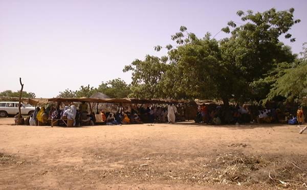
2.1 การอธิบายแบบสั้น ๆ ของเทคโนโลยี
คำจำกัดความของเทคโนโลยี:
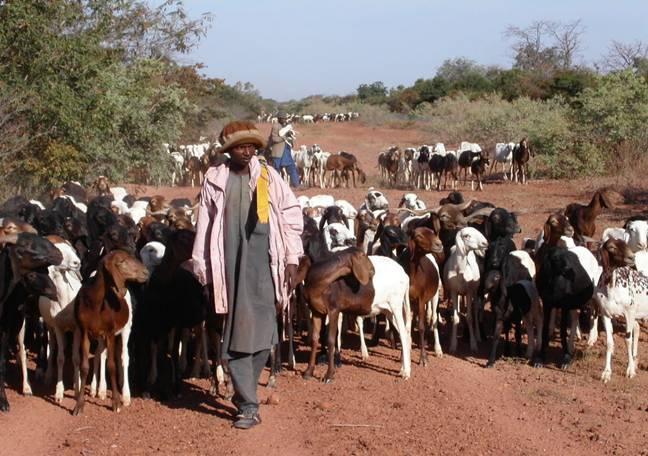
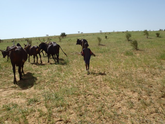
The ‘couloirs de passage’ are formally defined passageways which channel the movements of livestock herds in the agro-pastoral zones of Niger, by linking pastures, water points and coralling areas, be it within village areas (internal couloirs) or on open land (external couloirs).
2.2 การอธิบายแบบละเอียดของเทคโนโลยี
คำอธิบาย:
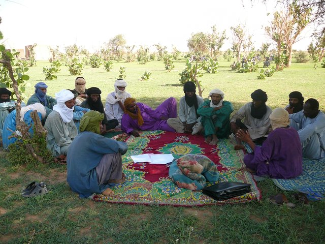
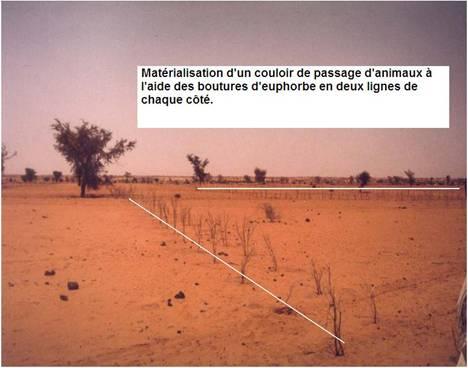
The main goal of the couloirs is the prevention of conflict between agriculturalists and pastoralists regarding the use of limited land and water resources. These conflicts are often provoked by cattle entering cropping areas. The establishment of demarcated passageways allows the livestock to access water points and pastures without causing damage to cropland. The corridors are regulated through the ‘code rural’ – a national law defining the land use rights of the pastoralists. Demarcation of couloirs is based on a consensual decision of all concerned interest groups. Internal couloirs are negotiated in a general on-site assembly involving all stakeholders (farmers, breeders, women’s groups, local authorities). For the demarcation of external couloirs the involvement of transhumance herders and neighboring villages is indispensable. Once an agreement on the course of the couloir is achieved, demarcation with stones and/or boundary planting with selected tree species is carried out by the local land users - with financial and technical assistance of the government or NGOs. Common species involve: Euphorbia balsamifera, Acacia spp. (A. nilotica; A. senegal); and Faidherbia albida. Management committees at the community level draw up regulations for the management of the couloirs (maintenance and protection of vegetation). Protection of plants is achieved through dead branches (at the initial stage), daily control by forest guards, and information campaigns. The technology is a sustainable solution to the described conflicts. As a valuable by-product the trees along the demarcation lines provide of wood and non-woody by-products.
2.3 รูปภาพของเทคโนโลยี
อัลบั้มสื่อบันทึก
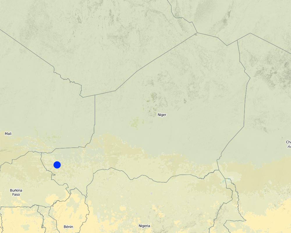
2.5 ประเทศภูมิภาค หรือสถานที่ตั้งที่เทคโนโลยีได้นำไปใช้และได้รับการครอบคลุมโดยการประเมินนี้
ประเทศ:
ไนเจอร์
ภูมิภาค/รัฐ/จังหวัด:
Tillabéri North
ระบุการกระจายตัวของเทคโนโลยี:
- ใช้ ณ จุดที่เฉพาะเจาะจงหรือเน้นไปยังบริเวณพื้นที่ขนาดเล็ก
Map
×2.7 คำแนะนำของเทคโนโลยี
ให้ระบุว่าเทคโนโลยีถูกแนะนำเข้ามาอย่างไร:
- ทางโครงการหรือจากภายนอก
3. การจัดประเภทของเทคโนโลยี SLM
3.1 วัตถุประสงค์หลักของเทคโนโลยี
- สร้างผลกระทบทางด้านสังคมที่เป็นประโยชน์
3.2 ประเภทของการใช้ที่ดินในปัจจุบันที่ได้นำเทคโนโลยีไปใช้
Land use mixed within the same land unit:
ใช่
Specify mixed land use (crops/ grazing/ trees):
- ปศุสัตว์ร่วมกับการทำป่าไม้ (Silvo-pastoralism)

ทุ่งหญ้าเลี้ยงสัตว์
Extensive grazing:
- กึ่งโนแมนดิซึ่มหรือแพสโตแรลลิซึ่ม (Semi-nomadism/pastoralism)

ป่า/พื้นที่ทำไม้
แสดงความคิดเห็น:
Major land use problems (land users’ perception): Soil erosion by water, soil erosion by wind and biological degradation; Primary problem addressed is conflicts between livestock and agriculture producers around natural resources
Semi-nomadism / pastoralism: Yes
Future (final) land use (after implementation of SLM Technology): Mixed: Ms: Silvo-pastoralism
3.3 Has land use changed due to the implementation of the Technology?
Has land use changed due to the implementation of the Technology?
- Yes (Please fill out the questions below with regard to the land use before implementation of the Technology)

พื้นที่ปลูกพืช
- การปลูกพืชล้มลุกอายุปีเดียว
3.4 การใช้น้ำ
การใช้น้ำของที่ดินที่มีการใช้เทคโนโลยีอยู่:
- จากน้ำฝน
3.5 กลุ่ม SLM ที่ตรงกับเทคโนโลยีนี้
- การจัดการปศุสัตว์และทุ่งหญ้าเลี้ยงสัตว์
3.6 มาตรการ SLM ที่ประกอบกันเป็นเทคโนโลยี

มาตรการอนุรักษ์ด้วยวิธีพืช
- V1: ต้นไม้และพุ่มไม้คลุมดิน

มาตรการอนุรักษ์ด้วยการจัดการ
- M3: การวางผังตามสิ่งแวดล้อมทางธรรมชาติและสิ่งแวดล้อมของมนุษย์
แสดงความคิดเห็น:
Type of vegetative measures: scattered / dispersed
3.7 รูปแบบหลักของการเสื่อมโทรมของที่ดินที่ได้รับการแก้ไขโดยเทคโนโลยี

การกัดกร่อนของดินโดยน้ำ
- Wt (Loss of topsoil): การสูญเสียดินชั้นบนหรือการกัดกร่อนที่ผิวดิน

การกัดกร่อนของดินโดยลม
- Et (Loss of topsoil): การสูญเสียดินชั้นบน

การเสื่อมโทรมของดินทางด้านชีวภาพ
- Bc (Reduction of vegetation cover): การลดลงของจำนวนพืชที่ปกคลุมดิน
แสดงความคิดเห็น:
Main type of degradation addressed: Wt: loss of topsoil / surface erosion, Et: loss of topsoil, Bc: reduction of vegetation cover
3.8 การป้องกัน การลดลง หรือการฟื้นฟูความเสื่อมโทรมของที่ดิน
ระบุเป้าหมายของเทคโนโลยีกับความเสื่อมโทรมของที่ดิน:
- ป้องกันความเสื่อมโทรมของที่ดิน
4. ข้อมูลจำเพาะด้านเทคนิค กิจกรรมการนำไปปฏิบัติใช้ ปัจจัยนำเข้า และค่าใช้จ่าย
4.1 แบบแปลนทางเทคนิคของเทคโนโลยี
ข้อมูลจำเพาะด้านเทคนิค (แบบแปลนทางเทคนิคของเทคโนโลยี):
Technical knowledge required for field staff / advisors: high (facilitator of code rural)
Technical knowledge required for land users: low (pastors and workers)
Main technical functions: increase of biomass (quantity), promotion of vegetation species and varieties (quality, eg palatable fodder)
Trees/ shrubs species: Euphorbia balsamifera, Acacia spp. (A. nilotica; A. senegal) and Faidherbia albida
4.2 ข้อมูลทั่วไปเกี่ยวกับการคำนวณปัจจัยนำเข้าและค่าใช้จ่าย
ระบุสกุลเงินที่ใช้คำนวณค่าใช้จ่าย:
- USD
ระบุค่าเฉลี่ยของค่าจ้างในการจ้างแรงงานต่อวัน:
1.5
4.3 กิจกรรมเพื่อการจัดตั้ง
| กิจกรรม | Timing (season) | |
|---|---|---|
| 1. | Identification of an existing couloir or definition of a new passageway by means of a general assembly | |
| 2. | Alignment of corridor boundaries e.g. by establishing stone lines. Internal couloirs are 10 to 50 m wide, whereas external couloirs exceed a width of 50 m | |
| 3. | Digging 40 cm deep pits; tree planting along boundaries (with a spacing of 1-3 meters, depending on the species selected and the secondary objective) |
4.4 ค่าใช้จ่ายของปัจจัยนำเข้าที่จำเป็นสำหรับการจัดตั้ง
| ปัจจัยนำเข้า | หน่วย | ปริมาณ | ค่าใช้จ่ายต่อหน่วย | ค่าใช้จ่ายทั้งหมดต่อปัจจัยนำเข้า | %ของค่าใช้จ่ายที่ก่อให้เกิดขึ้นโดยผู้ใช้ที่ดิน | |
|---|---|---|---|---|---|---|
| แรงงาน | Identification of an existing couloir or definition of a new passageway | persons/day | 25.0 | 1.5 | 37.5 | 5.0 |
| วัสดุด้านพืช | Tree planting along boundaries (seedlings) | pieces | 670.0 | 2.05 | 1373.5 | 5.0 |
| ค่าใช้จ่ายทั้งหมดของการจัดตั้งเทคโนโลยี | 1411.0 | |||||
| Total costs for establishment of the Technology in USD | 1411.0 | |||||
ถ้าผู้ใช้ที่ดินรับภาระน้อยกว่า 100% ของค่าใช้จ่าย ให้ระบุว่าใครเป็นผู้รับผิดชอบส่วนที่เหลือ:
Government or NGO's
4.5 การบำรุงรักษาสภาพหรือกิจกรรมที่เกิดขึ้นเป็นประจำ
| กิจกรรม | ช่วงระยะเวลา/ความถี่ | |
|---|---|---|
| 1. | Protection of trees (through dead branches, guards, information campaigns) | |
| 2. | Replanting tree seedlings to fill gaps (annually, beginning of rainy season) |
4.6 ค่าใช้จ่ายของปัจจัยนำเข้าและกิจกรรมที่เกิดขึ้นเป็นประจำที่ต้องการการบำรุงรักษา (ต่อปี)
| ปัจจัยนำเข้า | หน่วย | ปริมาณ | ค่าใช้จ่ายต่อหน่วย | ค่าใช้จ่ายทั้งหมดต่อปัจจัยนำเข้า | %ของค่าใช้จ่ายที่ก่อให้เกิดขึ้นโดยผู้ใช้ที่ดิน | |
|---|---|---|---|---|---|---|
| แรงงาน | Protection of trees | persons/day | 4.0 | 1.5 | 6.0 | 100.0 |
| วัสดุด้านพืช | Replanting tree seedlings | pieces | 67.0 | 2.0448 | 137.0 | 100.0 |
| ค่าใช้จ่ายทั้งหมดของการบำรุงรักษาสภาพเทคโนโลยี | 143.0 | |||||
| Total costs for maintenance of the Technology in USD | 143.0 | |||||
แสดงความคิดเห็น:
Costs for seedlings were calculated for a couloir length of 1 km and a spacing of 3 m between plants (one tree line on each side). Seedling production is financed by projects, only transport costs are met by land users.
4.7 ปัจจัยสำคัญที่สุดที่มีผลกระทบต่อค่าใช้จ่าย
ปัจจัยสำคัญที่สุดที่มีผลกระทบต่อค่าใช้จ่ายต่างๆ:
The costs of the planning meeting (general assembly) and the stones for delimitation were not taken into account. Daily salary for field work is US$ 1.5.
5. สิ่งแวดล้อมทางธรรมชาติและของมนุษย์
5.1 ภูมิอากาศ
ฝนประจำปี
- < 250 ม.ม.
- 251-500 ม.ม.
- 501-750 ม.ม.
- 751-1,000 ม.ม.
- 1,001-1,500 ม.ม.
- 1,501-2,000 ม.ม.
- 2,001-3,000 ม.ม.
- 3,001-4,000 ม.ม.
- > 4,000 ม.ม.
เขตภูมิอากาศเกษตร
- กึ่งแห้งแล้ง
Thermal climate class: tropics
5.2 สภาพภูมิประเทศ
ค่าเฉลี่ยความลาดชัน:
- ราบเรียบ (0-2%)
- ลาดที่ไม่ชัน (3-5%)
- ปานกลาง (6-10%)
- เป็นลูกคลื่น (11-15%)
- เป็นเนิน (16-30%)
- ชัน (31-60%)
- ชันมาก (>60%)
ธรณีสัณฐาน:
- ที่ราบสูง/ที่ราบ
- สันเขา
- ไหล่เขา
- ไหล่เนินเขา
- ตีนเนิน
- หุบเขา
ระดับความสูง:
- 0-100 เมตร
- 101-500 เมตร
- 501-1,000 เมตร
- 1,001-1,500 เมตร
- 1,501-2,000 เมตร
- 2,001-2,500 เมตร
- 2,501-3,000 เมตร
- 3,001-4,000 เมตร
- > 4,000 เมตร
5.3 ดิน
ค่าเฉลี่ยความลึกของดิน:
- ตื้นมาก (0-20 ซ.ม.)
- ตื้น (21-50 ซ.ม.)
- ลึกปานกลาง (51-80 ซ.ม.)
- ลึก (81-120 ซ.ม.)
- ลึกมาก (>120 ซ.ม.)
เนื้อดิน (ดินชั้นบน):
- หยาบ/เบา (ดินทราย)
อินทรียวัตถุในดิน:
- ต่ำ (<1%)
(ถ้ามี) ให้แนบคำอธิบายเรื่องดินแบบเต็มหรือระบุข้อมูลที่มีอยู่ เช่น ชนิดของดิน ค่า pH ของดินหรือความเป็นกรดของดิน ความสามารถในการแลกเปลี่ยนประจุบวก ไนโตรเจน ความเค็ม เป็นต้น:
Soil fertility is medium
Soil drainage / infiltration is good but low in case of soil crusting
5.6 ลักษณะของผู้ใช้ที่ดินที่นำเทคโนโลยีไปปฏิบัติใช้
แนวทางการตลาดของระบบการผลิต:
- เพื่อการยังชีพ (หาเลี้ยงตนเอง)
- mixed (subsistence/ commercial)
เป็นรายบุคคล/ครัวเรือน:
- กลุ่ม/ชุมชน
ระดับของการใช้เครื่องจักรกล:
- การใช้กำลังจากสัตว์
ระบุลักษณะอื่นๆที่เกี่ยวข้องของผู้ใช้ที่ดิน:
Population density: 10-50 persons/km2
5.7 Average area of land used by land users applying the Technology
- < 0.5 เฮกตาร์
- 0.5-1 เฮกตาร์
- 1-2 เฮกตาร์
- 2-5 เฮกตาร์
- 5-15 เฮกตาร์
- 15-50 เฮกตาร์
- 50-100 เฮกตาร์
- 100-500 เฮกตาร์
- 500-1,000 เฮกตาร์
- 1,000-10,000 เฮกตาร์
- >10,000 เฮกตาร์
5.8 กรรมสิทธิ์ในที่ดิน สิทธิในการใช้ที่ดินและสิทธิในการใช้น้ำ
กรรมสิทธิ์ในที่ดิน:
- รายบุคคล ได้รับสิทธิครอบครอง
สิทธิในการใช้ที่ดิน:
- เกี่ยวกับชุมชน (ถูกจัดระเบียบ)
- รายบุคคล
6. ผลกระทบและสรุปคำบอกกล่าว
6.1 ผลกระทบในพื้นที่ดำเนินการ (On-site) จากการใช้เทคโนโลยี
ผลกระทบทางด้านเศรษฐกิจและสังคม
การผลิต
การผลิตพืชผล
การผลิตพืชที่ใช้เลี้ยงปศุสัตว์
คุณภาพพืชที่ใช้เลี้ยงปศุสัตว์
การผลิตสัตว์
รายได้และค่าใช้จ่าย
รายได้จากฟาร์ม
ผลกระทบด้านสังคมวัฒนธรรมอื่น ๆ
โอกาสทางวัฒนธรรม
สถาบันของชุมชน
แสดงความคิดเห็น/ระบุ:
Through mutual aid in technology implementation
สถาบันแห่งชาติ
แสดงความคิดเห็น/ระบุ:
Code rural secretariat
SLM หรือความรู้เรื่องความเสื่อมโทรมของที่ดิน
ผลกระทบด้านนิเวศวิทยา
ดิน
สิ่งปกคลุมดิน
การสูญเสียดิน
การหมุนเวียนและการเติมของธาตุอาหาร
ความหลากหลายทางชีวภาพของพืชและสัตว์
มวลชีวภาพ/เหนือดินชั้น C
ความหลากหลายทางชีวภาพของสัตว์
ลดความเสี่ยงของภัยพิบัติ
ความเสี่ยงจากไฟ
ความเร็วของลม
6.2 ผลกระทบนอกพื้นที่ดำเนินการ (Off-site) จากการใช้เทคโนโลยี
ตะกอนที่ถูกพัดพามาโดยลม
ความเสียหายต่อพื้นที่เพาะปลูกของเพื่อนบ้าน
ความเสียหายต่อโครงสร้างพื้นฐานของรัฐหรือของเอกชน
6.3 การเผชิญและความตอบสนองของเทคโนโลยีต่อการเปลี่ยนแปลงสภาพภูมิอากาศที่ค่อยเป็นค่อยไป และสภาพรุนแรงของภูมิอากาศ / ภัยพิบัติ (ที่รับรู้ได้โดยผู้ใช้ที่ดิน)
แสดงความคิดเห็น:
Technology is sensitive to climatic extremes (such as droughts and floods)
6.4 การวิเคราะห์ค่าใช้จ่ายและผลประโยชน์ที่ได้รับ
ผลประโยชน์ที่ได้รับเปรียบเทียบกับค่าใช้จ่ายในการจัดตั้งเป็นอย่างไร (จากมุมมองของผู้ใช้ที่ดิน)
ผลตอบแทนระยะสั้น:
ด้านบวก
ผลตอบแทนระยะยาว:
ด้านบวกอย่างมาก
ผลประโยชน์ที่ได้รับเปรียบเทียบกับค่าใช้จ่ายในการบำรุงรักษาหรือต้นทุนที่เกิดขึ้นซ้ำอีก เป็นอย่างไร (จากมุมมองของผู้ใช้ที่ดิน)
ผลตอบแทนระยะสั้น:
ด้านบวก
ผลตอบแทนระยะยาว:
ด้านบวกอย่างมาก
แสดงความคิดเห็น:
Peace between communities is the key result on short term and on long term. Ecological and economic benefits are linked to the plantation of trees and the improved management of natural resources
6.5 การปรับตัวของเทคโนโลยี
Of all those who have adopted the Technology, how many did so spontaneously, i.e. without receiving any material incentives/ payments?
- 0-10%
แสดงความคิดเห็น:
There is a strong trend towards spontaneous adoption of the Technology
Comments on adoption trend: for prevention of conflicts and land degradation
6.7 จุดแข็ง / ข้อได้เปรียบ / โอกาสของเทคโนโลยี
| จุดแข็ง / ข้อได้เปรียบ / โอกาสในทัศนคติของผู้รวบรวมหรือวิทยากรหลัก |
|---|
| The technology provides a sustainable solution to conflicts between agriculturalists and pastoralists |
6.8 จุดอ่อน / ข้อเสียเปรียบ / ความเสี่ยงของเทคโนโลยีและวิธีการแก้ไข
| จุดอ่อน / ข้อเสียเปรียบ / ความเสี่ยงในทัศนคติของผู้ใช้ที่ดิน | มีวิธีการแก้ไขได้อย่างไร |
|---|---|
| Implementation constraints: plant production is very expensive and reaching a consensus on the transformation of private cropland to communal passageways is very difficult | definition of the couloirs as public infrastructure and enhancement of organizational capacities of the local population through training and information sessions |
| Maintenance constraints: maintenance can only be realized by adjacent land owners, as the community organizations are weak | reinforce the institutional capacities of livestock owners and farmers to manage the couloirs |
| In the pastoral zone the couloirs lead to conflicts between pastoralists and private ranches | establish community-based land tenure commissions and introduce new laws on land property in the pastoral zone |
7. การอ้างอิงและการเชื่อมต่อ
7.2 การอ้างอิงถึงสิ่งตีพิมพ์
หัวข้อ, ผู้เขียน, ปี, หมายเลข ISBN:
Projet LUCOP/Tillabéry. 2004. Referential des measures techniques de recuperation, de protection et d’exploitation durable des terres, 2nd edition, 2004, 51 pp
หัวข้อ, ผู้เขียน, ปี, หมายเลข ISBN:
Hiernaux P., E. Tielkes, E. Schlecht. 2001. Elevage et gestion des parcours au Sahel, Workshop proceedings organised by Eric Tielkes et Abdoulaye Soumaila, Verlag Ulrich E. Grauer, Beuren, Stuttgart, Germany, 2001
7.3 Links to relevant online information
ชื่อเรื่องหรือคำอธิบาย:
Soumaila A.S. 2003. Base de données du code rural
URL:
www.case.ibimet.cnr.it/den/Documents/code_rural/start.html
ลิงก์และโมดูล
ขยายทั้งหมด ย่อทั้งหมดลิงก์
Pastoralisme au Niger : Système de suivi des … [ไนเจอร์]
Cette approche traditionnelle initialement, soutenue par le Dispositif National de Prévention et de Gestion des Catastrophes et des Crises Alimentaires (DNPGCCA), se présente sous la forme d’un Système d'Information Géographique (SIG) intégrant les ressources hydrauliques, le mouvement des populations et la répartition spatiale et quantitative des pâturages. L’objectif de l’approche …
- ผู้รวบรวม: Soumaila Abdoulaye
Champ Ecole Pastorale [ไนเจอร์]
Le Champ Ecole (CE) Pastorale, une école «sans murs», est un cadre de rencontre et de formation pour un groupe de 20 à 30 éleveurs de la zone pastorale du Niger, qui se déroule sur une aire de pâturage communautaire, tout au long de l'année. C’est un lieu d’échange d’expériences …
- ผู้รวบรวม: Soumaila Abdoulaye
โมดูล
ไม่มีโมดูล