Gradual development of bench terraces from contour ditches [ຕາຈິກິສະຕານ]
- ການສ້າງ:
- ປັບປູງ:
- ຜູ້ສັງລວມຂໍ້ມູນ: Manuchehr Rakhmatdzhonov
- ບັນນາທິການ: –
- ຜູ້ທົບທວນຄືນ: Laura Ebneter, Alexandra Gavilano, Fabian Ottiger, Joana Eichenberger
Ташакули тадричии терассахо тавассути чуйборхои контури
technologies_1043 - ຕາຈິກິສະຕານ
- ສະຫຼຸບສັງລວມຢ່າງທັງໝົດທີ່ເປັນ PDF
- ສັງລວມເປັນບົດ PDF ເພື່ອສັ່ງພິມ
- ສັງລວມເປັນບົດ ຢູ່ໃນ browser
- ບົດສະຫຼຸບ ສະບັບເຕັມ (ບໍ່ມີແບບຟອມ)
- Gradual development of bench terraces from contour ditches: Aug. 20, 2019 (inactive)
- Gradual development of bench terraces from contour ditches: Nov. 2, 2021 (public)
- Gradual development of bench terraces from contour ditches: July 22, 2017 (inactive)
- Gradual development of bench terraces from contour ditches: June 2, 2017 (inactive)
- Gradual development of bench terraces from contour ditches: May 31, 2017 (inactive)
- Gradual development of bench terraces from contour ditches: Dec. 27, 2016 (inactive)
ເບິ່ງພາກສ່ວນ
ຂະຫຍາຍທັງໝົດ ຍຸບທັງໝົດ1. ຂໍ້ມູນທົ່ວໄປ
1.2 ຂໍ້ມູນ ການຕິດຕໍ່ພົວພັນ ຂອງບຸກຄົນທີ່ສໍາຄັນ ແລະ ສະຖາບັນ ທີ່ມີສ່ວນຮ່ວມ ໃນການປະເມີນເອກກະສານ ເຕັກໂນໂລຢີ
hafizova tahmina
Deutsche Welthungerhilfe, Tajikistan
ຕາຈິກິສະຕານ
ຊື່ໂຄງການ ທີ່ອໍານວຍຄວາມສະດວກ ໃນການສ້າງເອກກະສານ/ປະເມີນ ເຕັກໂນໂລຢີ (ຖ້າກ່ຽວຂ້ອງ)
Pilot Program for Climate Resilience, Tajikistan (WB / PPCR)ຊື່ສະຖາບັນ (ຫຼາຍສະຖາບັນ) ທີ່ອໍານວຍຄວາມສະດວກ ໃນການສ້າງເອກກະສານ / ປະເມີນ ເຕັກໂນໂລຢີ (ຖ້າກ່ຽວຂ້ອງ)
Welthungerhilfe (Welthungerhilfe) - ຕາຈິກິສະຕານ1.3 ເງື່ອນໄຂ ກ່ຽວກັບ ການນໍາໃຊ້ຂໍ້ມູນເອກະສານ ທີ່ສ້າງຂື້ນ ໂດຍຜ່ານ ອົງການພາບລວມຂອງໂລກ ທາງດ້ານແນວທາງ ແລະ ເຕັກໂນໂລຢີ ຂອງການອານຸລັກ ທໍາມະຊາດ (WOCAT)
ຜູ້ປ້ອນຂໍ້ມູນ ແລະ ບຸກຄົນສຳຄັນ ທີ່ໃຫ້ຂໍ້ມູນ (ຫຼາຍ) ຍິນຍອມ ຕາມເງື່ອນໄຂ ໃນການນຳໃຊ້ຂໍ້ມູນ ເພື່ອສ້າງເປັນເອກກະສານຂອງ WOCAT:
ແມ່ນ
1.5 ແບບສອບຖາມທີ່ອ້າງອີງເຖີງແນວທາງ ການຄຸ້ມຄອງທີ່ດິນແບບຍືນຍົງ (ໄດ້ເຮັດເປັນເອກະສານທີ່ໃຊ້ WOCAT)
Facilitation of micro-watershed management for farmers [ຕາຈິກິສະຕານ]
Relying on integrated watershed management principles, farmers were assisted by the project to implement soil and water conservation measures in a microwatershed.
- ຜູ້ສັງລວມຂໍ້ມູນ: Manuchehr Rakhmatdzhonov
2. ການອະທິບາຍ ເຕັກໂນໂລຢີ ຂອງການຄຸ້ມຄອງ ທີ່ດິນແບບຍືນຍົງ
2.1 ຄໍາອະທິບາຍສັ້ນຂອງ ເຕັກໂນໂລຢີ
ການກຳໜົດຄວາມໝາຍ ຂອງເຕັກໂນໂລຢີ:
Use of the SLM technology facilitates the development of bench terraces from contour channels by gradually removing soil material up the slope for an estimated 5 years until the terraces on the slope reach a desired width of 1.2 m.
2.2 ການອະທິບາຍ ລາຍລະອຽດ ຂອງເຕັກໂນໂລຢີ
ການພັນລະນາ:
The SLM technology is thought to stop water run-off resulting in the prevention of damage to the top soil on steep slopes. This enables better distribution and infiltration of water into the soil. A complementing live fence, along with a metal net along the perimeter aim to stop livestock grazing. Contour ditches are planted in intervals with fruit trees, and the live fence is made of a combination of fire wood, trees and bushes. This combination makes possible the establishment of an agro forestry system on a slope in an area with limited irrigation using making use of the natural rainfall.
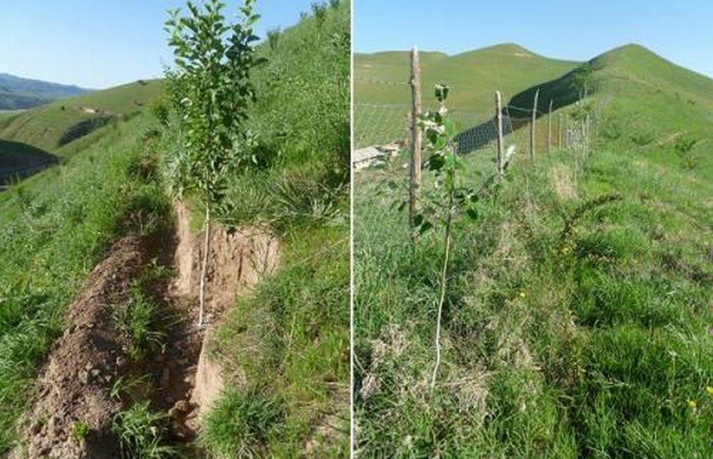
Details: 1. Ditches are dug out along the contour lines drawn by an "A" frame on the slope. 2. Seedlings are planted in 5 metre intervals, positioned right in the middle of the ditch. 3. The back wall behind each tree (upslope) has a half moon cutting to enable an even water/moisture supply. 4. The ditches are barriered with "septas" between two trees to trap water in the individual sections. 5. Horizontally across the ditches, the tree species vary, but vertically are homogeneous. 6. The strips between ditches are left free to enable natural grass to grow. 7. The residual soil material is mounted in front of the ditches in piles the width of a shovel. 8. The complementing perimeter live fence and metal net (1.5m height) is supported by wooden poles made of Acacia trees. (Assumed life span of poles is 25 years). 9. Improvised drip irrigation with 5 litre plastic bottles is used together with mulch coverage beneath the trees. 10. Species composition: apple, cherry, apricot, grape, walnut, pomegranate. In the garden; species of Acacia, Ailantus, dogroses and willow act as a live fence.
Purpose of the Technology: The aim of this system is to significantly reduce the water run-off that removes the top soil, and to subsequently prevent water erosion, and the formation/development of gullies. This can be achieved through the following methods; conserving the available resources and using them more efficiently, prevention overgrazing and improving the natural soil cover, as well as changing the type of land management towards a more sustainable and profitable one.
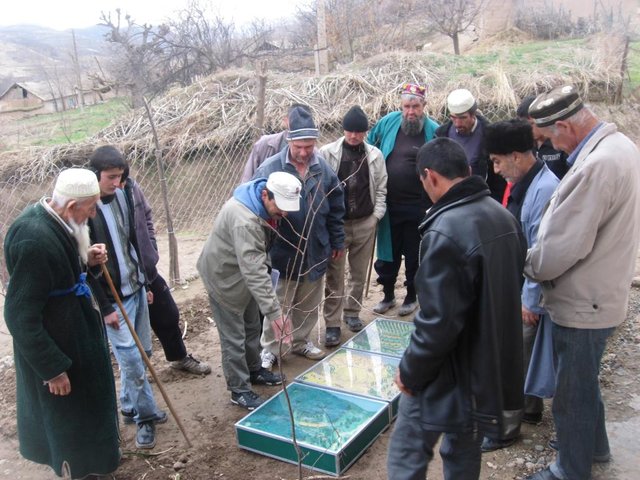
Establishment / maintenance activities and inputs: The plot was established on one side of a micro watershed. In mid February the contour lines were identified using an “A” frame. Digging of contour ditches then took until late February. The material was accumulated down the slope in deposits the width of a shovel to build a riser. At the beginning of March all the fruit tree seedlings were planted in the middle of the ditches. Perimeter fencing was constructed and live fence plants were planted up until late March. In May, the grass around the trees was cut and used for mulching beneath the trees. During June and July in the first year the plants needed watering 3 times a week which was done using a drip irrigation system with 5 litre plastic bottles. To help prevent the water heating and evaporating, the bottles were left under the mulch cover. Mulching and irrigation are repeated every dry and hot season. Every spring, the soil material is removed alongside the inner wall of the ditch just taking an amount that equals the width of a shovel, and accumulated down the slope to extend the riser. Materials required include: (1) Ditches: hand tools, stakes, rope, “A” frame, (2) Live fence: seedlings of Acacia, Ailantus, willow and dog rose, (3) Fencing: metal net, wooden poles, metal wire, (4) Cow dung, lime suspension, straw, mulch, plastic bottles.
Natural / human environment: The watershed can be characterised as follows: Hydrology - surface water is available only at times of rain and snow melt, this can be used for irrigation only. No sources of potable water exist. Soils are of loess type, as generally characteristic to the whole area. Flora - natural grasses prevail in the micro watershed, 9 species could be identified. Natural bushes and trees were completely removed due to high demand for fuelwood. Cultivation of rare tree varieties and household gardening was practiced in advance of the project. Fauna - Wild animals are often still seen such as turtles, lizards and snakes. Farm animals - mixed breeds of cattle, sheep and goats are very important. The households in this micro watershed area own almost 350 animals. The majority of these are kept for the summer season in adjacent pastures. The micro watershed was first inhabited in early 2000. Five households were established with a total of around 40 inhabitants. Family heads tend to be in their early 40s. Families have 7 to 9 members, including 5 to 7 children. All are of Tajik ethnicity, and Muslim, open to secular values. Of these 5 households, only 4 households have adopted the SLM technology. The fifth household only decided to join the project after witnessing their neighbour’s positive experiences. Both spouses tended to be involved in the activities. Both men and women took part in the training sessions and orientation meeting. However, it is likely that most decisions were made by the men, after the women had shared their ideas. Work load: providing the external inputs, construction and the heavy manual labour were done by the men. Maintenance work: watering, mulching and grass cutting was shared between men and women. Digging and fencing were performed in "hashars" - community labour groups. As women spend more time at home working within their households, they tend to perform more maintenance work on the plot compared to men. Other activities away from the farms are important to the family budget providing a means of extra income. This often includes men’s long term migration to Russia to find work.
2.3 ຮູບພາບຂອງເຕັກໂນໂລຢີ
ສື່ຮູບພາບ
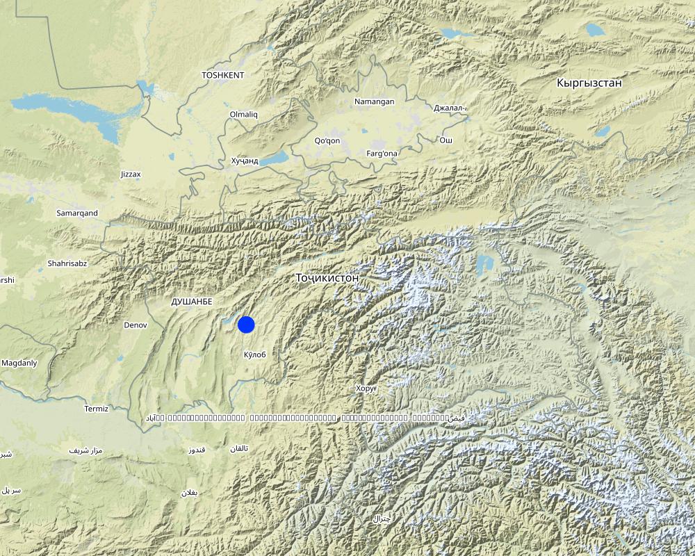
2.5 ປະເທດ / ເຂດ / ສະຖານທີ່ບ່ອນທີ່ ເຕັກໂນໂລຢີ ໄດ້ຮັບການນໍາໃຊ້ ແລະ ທີ່ຖືກປົກຄຸມດ້ວຍການປະເມີນຜົນ
ປະເທດ:
ຕາຈິກິສະຕານ
ພາກພື້ນ / ລັດ / ແຂວງ:
Tajikistan, Khatlon
ຂໍ້ມູນເພີ່ມເຕີມຂອງສະຖານທີ່:
Baljuvon, Khirob
ຄວາມຄິດເຫັນ:
Boundary points of the Technology area: North - 38.284233°N 69.639420°E
South - 38.278485°N 69.639555°E
East - 38.281854°N 69.641276°E
South - 38.281250°N 69.638009°E
Total area covered by the SLM Technology is 0.112 km2.
The application of the SLM technology is planned for the whole micro watershed which has a total area of 0.112 km2. Currently it has been impemented in 0.07km2 of this watershed.
Map
×2.6 ວັນທີໃນການຈັດຕັ້ງປະຕິບັດ
ຖ້າຫາກວ່າ ບໍ່ຮູ້ຈັກ ປີທີ່ຊັດເຈນ ແມ່ນໃຫ້ປະມານ ວັນທີເອົາ:
- ຕໍ່າກວ່າ 10 ປີ ຜ່ານມາ (ມາເຖິງປະຈຸບັນ)
2.7 ການນໍາສະເໜີ ເຕັກໂນໂລຢີ
ໃຫ້ລະບຸ ເຕັກໂນໂລຢີ ໄດ້ຖືກຈັດຕັ້ງປະຕິບັດຄືແນວໃດ?
- ໂດຍຜ່ານໂຄງການ / ການຊ່ວຍເຫຼືອຈາກພາຍນອກ
3. ການໃຈ້ແຍກ ເຕັກໂນໂລຢີ ໃນການຄຸ້ມຄອງ ດິນແບບຍືນຍົງ
3.2 ປະເພດການນໍາໃຊ້ທີ່ດິນ ໃນປະຈຸບັນ() ທີ່ເຕັກໂນໂລຢີ ໄດ້ຖືກນໍາໃຊ້

ດິນທີ່ປູກພືດ
- ການປູກພືດປະຈໍາປີ
- ພືດຢືນຕົ້ນ (ບໍ່ແມ່ນໄມ້)
- ເປັນໄມ້ຢືນຕົ້ນ ແລະ ໄມ້ພຸ່ມ ຈາກການປູກພືດ
ການປູກພືດປະຈຳປີ - ລະບຸປະເພດພືດ:
- ພືດອາຫານສັດ - ປະເພດຫຍ້າ
- espercet
ການປູກພືດຢືນຕົ້ນ(ບໍ່ແມ່ນໄມ້ໄມ້ຢືນຕົ້ນ) - ໃຫ້ລະບຸປະເພດພືດ:
- ໝາກເບີລີ
ການປູກພືດທີ່ເປັນຕົ້ນໄມ້ ແລະ ໄມ້ພຸ່ມ - ລະບຸປະເພດພືດ:
- ໝາກລະແຊ້ງ
- stone fruits (peach, apricot, cherry, plum, etc)
- ຕົ້ນຖົ່ວ ( ຖົ່ວເບຣຊິນ. ພິສຕາຄິໂອ. ວໍນັດ. ອ່າວມ້ອນ ແລະ ອື່ນໆ)
- ຫມາກໄມ້ນ້ອຍ (ຫມາກໂປມ, ໝາກຊາລີ, ໝາກຈອງ, ແລະອື່ນໆ)
- Ailantus, Acacia, dog rose, willow, poplar
ຈໍານວນ ລະດູການ ປູກໃນປີໜຶ່ງ:
- 1
ລະບຸ ຊະນິດ:
Longest growing period in days: 180Longest growing period from month to month: March - August
ມີການເຝືກປູກພືດແບບສັບຫວ່າງບໍ່?
ແມ່ນ
ຖ້າມີ, ໃຫ້ລະບຸວ່າປູກພືດຊະນິດໃດທີ່ປູກສັບຫວ່າງ:
tomatoes, paprica

ທົ່ງຫຍ້າລ້ຽງສັດ
ການລ້ຽງສັດແບບປ່ອຍ ຕາມທຳມະຊາດ:
- ແບບປ່ອຍ ຕາມທຳມະຊາດ
- ການລ້ຽງສັດແບບເຄີ່ງປ່ອຍ
ທົ່ງຫຍ້າລ້ຽງສັດແບບສຸມ / ການຜະລິດອາຫານສັດ:
- ຕັດຫຍ້າ ແລະ ຂົນຫຍ້າ / ບໍ່ມີທົ່ງຫຍ້າທໍາມະຊາດ
- Livestock density (if relevant): 50-100 LU /km2

ປ່າໄມ້ / ປ່າ
- (ເຄິ່ງ) ປ່າໄມ້ທໍາມະຊາດ / ປ່າປູກໄມ້
ຜົນຜະລິດ ແລະ ການບໍລິການ:
- ເຄື່ອງປ່າຂອງດົງ
- ໄມ້ຟືນ
- ໝາກໄມ້ ແລະ ແກ່ນຖົ່ວ
- ຜະລິດຕະພັນ ປ່າໄມ້ອື່ນໆ
- ທົ່ງຫຍ້າ
- ການອະນຸລັກທໍາມະຊາດ / ການປ້ອງກັນ
ຄວາມຄິດເຫັນ:
Major land use problems (compiler’s opinion): Implementation of land tenure rights at a local level was also a major barrier.
Major land use problems (land users’ perception): There is a soil and water conservation project in place to manage water runoff, soil erosion and gully formation. Low land productivity only allows for wheat production with long fallow periods. Improper pasture management has led to overall overgrazing.
Nomadism: animals taken to summer pastures
Semi-nomadism / pastoralism: animal graze around villages
Ranching: no practice
Cut-and-carry/ zero grazing: almost extinct
Improved pasture: no practice at all
Clear felling of (semi-)natural forests: No selection in times of electricity cuts in winter season.
Forest products and services: timber, fuelwood, fruits and nuts, grazing / browsing, other forest products / uses (honey, medical, etc.), nature conservation / protection
Future (final) land use (after implementation of SLM Technology): Mixed: Mf: Agroforestry
Constraints of infrastructure network (roads, railways, pipe lines, power lines): no irrigation network, heavy transports costs
3.3 ການນຳໃຊ້ທີ່ດິນ ມີການປ່ຽນແປງຍ້ອນການຈັດຕັ້ງທົດລອງເຕັກໂນໂລຢີ ແມ່ນບໍ່?
ການນຳໃຊ້ທີ່ດິນ ມີການປ່ຽນແປງຍ້ອນການຈັດຕັ້ງທົດລອງເຕັກໂນໂລຢີ ແມ່ນບໍ່?
- ແມ່ນ (ກະລຸນາຕື່ມໃສ່ ຄຳຖາມຂ້າງລຸ່ມນີ້ກ່ຽວກັບການນຳໃຊ້ທີ່ດິນ ກ່ອນການທົດລອງເຕັກໂນໂລຢີ)
ການນຳໃຊ້ທີ່ດິນ ປະສົມພາຍໃນພື້ນທີ່ດຽວກັນ:
ແມ່ນ
ລະບຸການນຳໃຊ້ທີ່ດິນແບບປະສົມ (ຜົນລະປູກ / ທົ່ງຫຍ້າລ້ຽງສັດ / ຕົ້ນໄມ້):
- ກະສິກໍາ-ປ່າໄມ້ ແບບປະສົມປະສານ
ທົ່ງຫຍ້າລ້ຽງສັດ

ການຕັ້ງຖິ່ນຖານ, ພື້ນຖານໂຄງລ່າງ
- ການຈາລະຈອນ: ຫົນທາງ, ທາງລົດໄຟ
- ພະລັງງານ: ທໍ່, ສາຍໄຟຟ້າ
ຄວາມຄິດເຫັນ:
Grazing land: Ge: Extensive grazing land
3.4 ການສະໜອງນ້ຳ
ຄວາມຄິດເຫັນ:
Water supply: rainfed, mixed rainfed - irrigated, rainfed
Water supply: post-flooding
post-flooding
3.6 ມາດຕະການ ການຄຸ້ມຄອງ ທີ່ດິນແບບຍືນຍົງ ປະກອບດ້ວຍ ເຕັກໂນໂລຢີ

ມາດຕະການ ທາງການກະສິກໍາ
- A1: ພືດ / ການປົກຫຸ້ມຂອງດິນ
- A2: ອິນຊີວັດຖຸ ຫຼື ຄວາມອຸດົມສົມບູນໃນດິນ
- A3: ການບໍາລຸງຮັກສາຊັ້ນໜ້າດິນ
A3: ລະບົບການໄຖແຕກຕ່າງກັນ:
A 3.1: ບໍ່ມີການໄຖ

ມາດຕະການ ທາງດ້ານພືດພັນ
- V1: ເປັນໄມ້ຢືນຕົ້ນ ແລະ ການປົກຫຸ້ມຂອງໄມ້ພຸ່ມ

ມາດຕະການໂຄງສ້າງ
- S1: ພັກຄັນໃດ

ມາດຕະການ ທາງດ້ານການຄຸ້ມຄອງ
- M1: ການປ່ຽນແປງ ປະເພດ ການນໍາໃຊ້ທີ່ດິນ
ຄວາມຄິດເຫັນ:
Main measures: agronomic measures, vegetative measures, structural measures, management measures
Type of agronomic measures: mixed cropping / intercropping, contour planting / strip cropping, mulching, legume inter-planting, manure / compost / residues, zero tillage / no-till, pits
Type of vegetative measures: aligned: -contour, aligned: -graded strips *<sup>3</sup>, aligned: -along boundary
3.7 ປະເພດດິນເຊື່ອມໂຊມ ຫຼັກທີ່ໄດ້ນໍາໃຊ້ ເຕັກໂນໂລຢີ

ດິນເຊາະເຈື່ອນ ໂດຍນໍ້າ
- Wt: ການສູນເສຍຊັ້ນໜ້າດິນ / ການເຊາະເຈື່ອນຜິວໜ້າດິນ
- Wg: ການເຊາະເຈື່ອນຮ່ອງນ້ຳ / ຫ້ວຍ

ການເຊື່ອມໂຊມ ທາງຊີວະພາບ
- Bc: ການຫຼຸດຜ່ອນການປົກຫຸ້ມຂອງພືດ
ຄວາມຄິດເຫັນ:
Main causes of degradation: soil management (Tillage on steep slope >35%.), deforestation / removal of natural vegetation (incl. forest fires) (Natural tree and shrubs removed completely.), over-exploitation of vegetation for domestic use, overgrazing (Stocking rates do exceed the standards in multiple times), disturbance of water cycle (infiltration / runoff) (Run-off is induced by maximum removal of vegetation cover.), land tenure (Unclear land right situation induces irresponsible attitudes.), inputs and infrastructure: (roads, markets, distribution of water points, other, …) (Very limited infrastructure development, vital infrastructure points are a long distance away.)
Secondary causes of degradation: Heavy / extreme rainfall (intensity/amounts) (Induces gully formation and mass movement.), droughts (If vegetation is dry then less soil cover is provided.), other natural causes (avalanches, volcanic eruptions, mud flows, highly susceptible natural resources, extreme topography, etc.) specify (The gradient is over 30%.), population pressure (Large family sizes, and high growth rates causes increased need for food and living space in the area.), poverty / wealth (Very limited financial power to develop the land.), labour availability (Though cheap labour is available, it takes much effort to organise communities to work together for SLM activities.), education, access to knowledge and support services (Basic schooling of children, no state provided extension or training after school age.), war and conflicts (The after-effects of recent civil war still have some influence.), governance / institutional (Communist attitudes still persist, very slow institutional development.)
3.8 ການປ້ອງກັນ, ການຫຼຸດຜ່ອນ, ຫຼືການຟື້ນຟູຂອງການເຊື່ອມໂຊມຂອງດິນ
ຄວາມຄິດເຫັນ:
Main goals: prevention of land degradation
Secondary goals: mitigation / reduction of land degradation, rehabilitation / reclamation of denuded land
4. ຂໍ້ກໍາໜົດ, ກິດຈະກໍາການປະຕິບັດ, ວັດຖຸດິບ, ແລະຄ່າໃຊ້ຈ່າຍ
4.1 ເຕັກນິກ ໃນການແຕ້ມແຜນວາດ ເຕັກໂນໂລຢີ
ຄຸນລັກສະນະ ຂອງເຕັກນິກ (ທີ່ກ່ຽວຂ້ອງ ກັບການແຕ້ມແຜນວາດ ທາງດ້ານເຕັກນີກ):
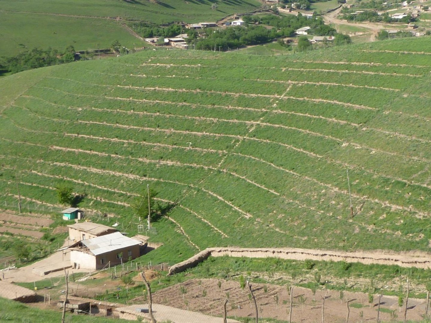
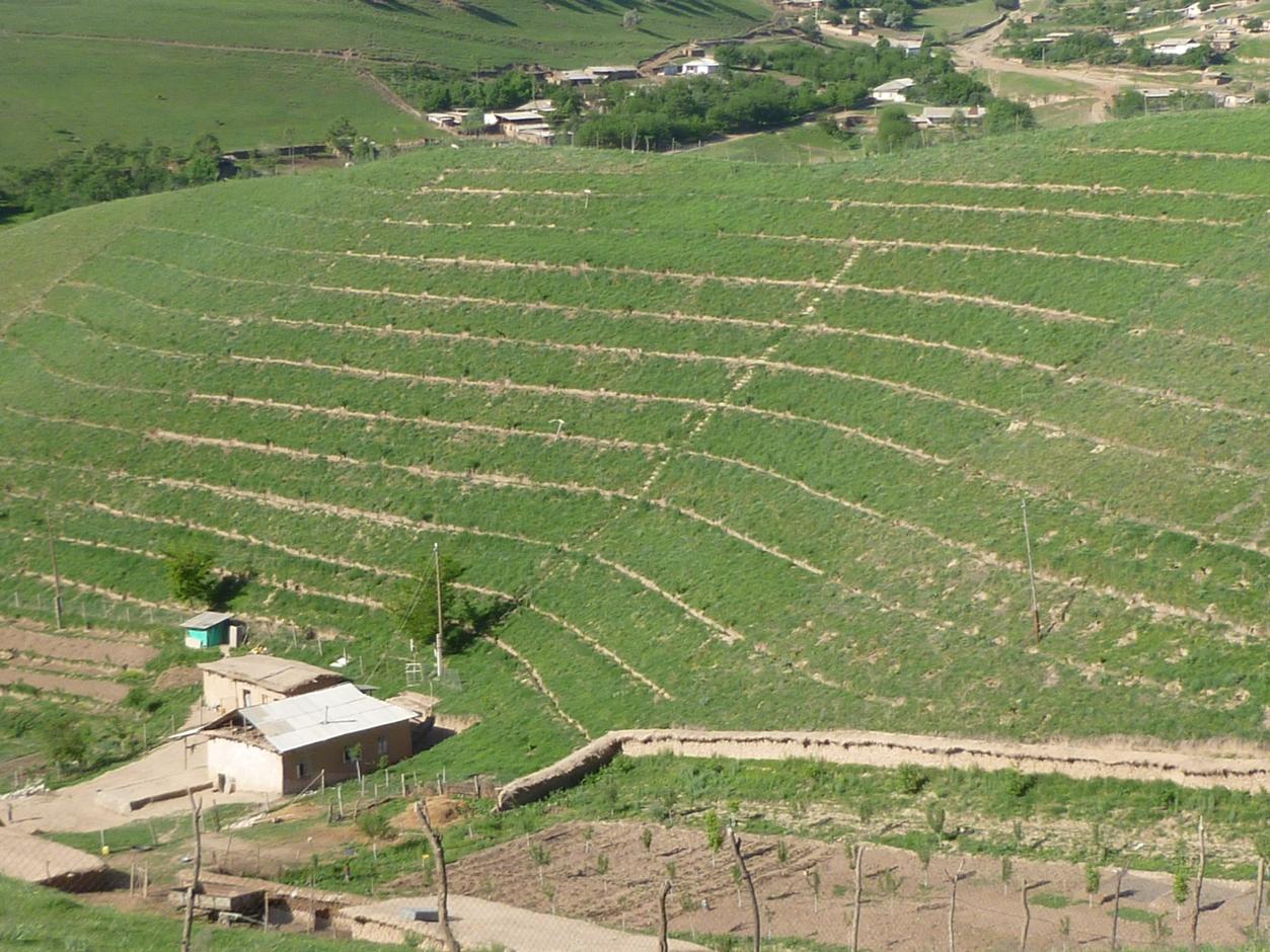
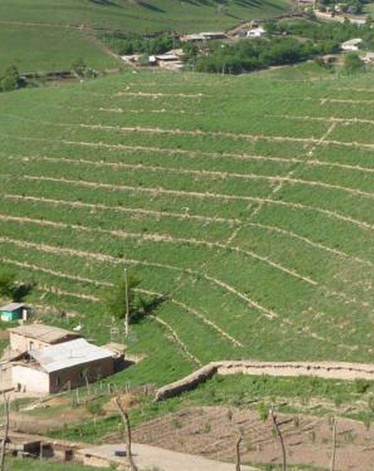
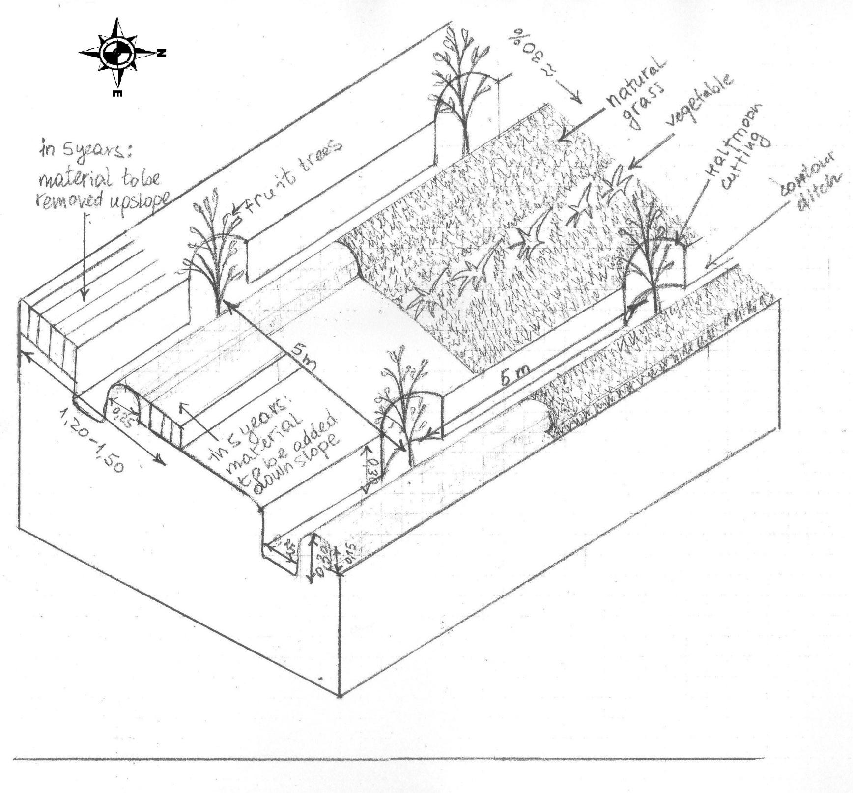
The drawing shows the contour ditches on a slope with a 25 - 30 % steepness. The gradient is 3-5%.
Vertically, the contour ditches are spaced at 5 m intervals. The upper left part of the drawing shows how the material on the slope will be removed in portions during the five years to create a levelled terrace. The ditches are planted with fruit trees, and strips of natural grass cover the space between the ditches. In the middle line of the strips in the bottom part of the plot the farmer has grown vegetables.
Location: Khirob village. Baljuvon/ Khatlon/ Tajikistan
Date: 06.05.2011
Technical knowledge required for field staff / advisors: high (Specific knowledge needed in the issues of integrated watershed management and technology.)
Technical knowledge required for land users: moderate (Training needed in terms of technology, planning and implementation of activities.)
Main technical functions: control of dispersed runoff: retain / trap, reduction of slope angle, increase of infiltration, promotion of vegetation species and varieties (quality, eg palatable fodder)
Secondary technical functions: control of dispersed runoff: impede / retard, improvement of ground cover, increase of surface roughness, improvement of topsoil structure (compaction), stabilisation of soil (eg by tree roots against land slides), increase / maintain water stored in soil, water harvesting / increase water supply, water spreading, increase of biomass (quantity), spatial arrangement and diversification of land use
Mixed cropping / intercropping
Material/ species: Growing a few tomatoes and paprica on the bottom strips.
Quantity/ density: 4plants m2
Remarks: Down slope alongside the ditches.
Contour planting / strip cropping
Material/ species: Wild vegetation is left to grow.
Quantity/ density: very dense
Remarks: Over 9 species counted on the plot all palatable, cut for hay and mulch.
Mulching
Material/ species: Mulching from natural grass, over 9 species.
Remarks: Ditches and trees covered beneath.
Legume inter-planting
Quantity/ density: 2 raisers.
Remarks: As a test to cover raiser surface.
Manure / compost / residues
Material/ species: Cattle dung suspended in water.
Quantity/ density: Once.
Remarks: Applied while planting the trees.
Zero tillage / no-till
Material/ species: No tillage for intercropping completed.
Pits
Material/ species: Pits were dug to plant seedlings.
Aligned: -contour
Vegetative material: T : trees / shrubs
Number of plants per (ha): 400
Vertical interval between rows / strips / blocks (m): 5
Spacing between rows / strips / blocks (m): 5
Vertical interval within rows / strips / blocks (m): 5
Width within rows / strips / blocks (m): 5
Aligned: -graded strips
Vegetative material: G : grass
Number of plants per (ha): na
Vertical interval between rows / strips / blocks (m): 1
Spacing between rows / strips / blocks (m): 3
Aligned: -along boundary
Vegetative material: T : trees / shrubs
Number of plants per (ha): 400
Spacing between rows / strips / blocks (m): 1
Trees/ shrubs species: Ailantus, Acacia, dog rose, willow, poplar
Fruit trees / shrubs species: Apple, grape, pear, apricot, cherry, pomegranate, mulberry, walnut
Perennial crops species: little alfalfa and espercet
Grass species: 9 naturally growing species
Slope (which determines the spacing indicated above): 30.00%
Gradient along the rows / strips: 25.00%
Retention/infiltration ditch/pit, sediment/sand trap
Vertical interval between structures (m): 5
Spacing between structures (m): 5
Depth of ditches/pits/dams (m): 0.3
Width of ditches/pits/dams (m): 0.25
Height of bunds/banks/others (m): 0.15
Width of bunds/banks/others (m): 0.25
Terrace: bench level
Vertical interval between structures (m): 3.50-3.80
Height of bunds/banks/others (m): 0.25
Width of bunds/banks/others (m): 1.20-1.50
Construction material (earth): the earth is removed upslope and added downslope to the front bank (raiser)
Slope (which determines the spacing indicated above): 25-30%
Lateral gradient along the structure: 3-5%
Vegetation is used for stabilisation of structures.
Change of land use type: Communal pasture land was turned into an agroforestry system
Change of land use practices / intensity level: Self subsistance, market orientated agroforestry system
Layout change according to natural and human environment: Along the contour lines of the slope
Major change in timing of activities: Major seasonal activities in three seasons: spring agronomic and vegetative measures, summer and autumn yield harvesting, clearing the branches
ຜູ້ຂຽນ:
Manuchehr Rakhmatdzhonov, 16, Firdavsi street, 734003 Dushanbe
4.2 ຂໍ້ມູນທົ່ວໄປກ່ຽວກັບການຄິດໄລ່ປັດໃຈຂາເຂົ້າໃນການຜະລິດ ແລະ ມູນຄ່າອື່ນໆ
ສະກຸນເງິນອື່ນໆ / ປະເທດອື່ນໆ (ລະບຸ):
Somoni
ຖ້າກ່ຽວຂ້ອງ, ໃຫ້ລະບຸອັດຕາແລກປ່ຽນຈາກ USD ເປັນສະກຸນເງິນທ້ອງຖິ່ນ (ເຊັ່ນ: 1 USD = 79.9 Brazilian Real): 1 USD =:
4.5
ລະບຸ ຄ່າຈ້າງ ຄ່າແຮງງານສະເລ່ຍ ຕໍ່ ວັນ:
5.00
4.3 ການສ້າງຕັ້ງກິດຈະກໍາ
| ກິດຈະກໍາ | Timing (season) | |
|---|---|---|
| 1. | Planting seedlings in contour ditches | February-March |
| 2. | Planting seedlings and bushes along the perimeter | March |
| 3. | Cost of seedlings: frutiouse and firewood trees | February -March |
| 4. | Gradual terracing by Broadening the ditch onslope and extending the raiser downslope | every spring during 5 years |
| 5. | Membership fees | |
| 6. | Attending the training | |
| 7. | Management of staff | |
| 8. | Taxes | |
| 9. | Membership fees | |
| 10. | None |
4.4 ຕົ້ນທຶນ ແລະ ປັດໄຈຂາເຂົ້າທີ່ຈໍາເປັນໃນຈັດຕັ້ງປະຕິບັດ
| ລະບຸ ປັດໃຈ ນໍາເຂົ້າ ໃນການຜະລີດ | ຫົວໜ່ວຍ | ປະລິມານ | ຕົ້ນທຶນ ຕໍ່ຫົວໜ່ວຍ | ຕົ້ນທຶນທັງໝົດ ຂອງປັດໃຈຂາເຂົ້າ ໃນການຜະລິດ | % ຂອງຕົ້ນທຶນທັງໝົດ ທີ່ຜູ້ນໍາໃຊ້ທີ່ດິນ ໃຊ້ຈ່າຍເອງ | |
|---|---|---|---|---|---|---|
| ແຮງງານ | Labour | 1.0 | 355.0 | 355.0 | 100.0 | |
| ແຮງງານ | Mulching | 1.0 | 4.5 | 4.5 | 100.0 | |
| ແຮງງານ | Planting seedlings in contour ditches | person days | 20.0 | 4.4 | 88.0 | 100.0 |
| ແຮງງານ | Planting seedlings and bushes along the perimeter | person days | 10.0 | 4.4 | 44.0 | 100.0 |
| ອຸປະກອນ | Set of shovels, hoes, picks | Set | 1.0 | 66.0 | 66.0 | 50.0 |
| ວັດສະດຸໃນການປູກ | mulching | 1.0 | 4.5 | 4.5 | 100.0 | |
| ວັດສະດຸໃນການປູກ | seedlings | 1.0 | 333.0 | 333.0 | 50.0 | |
| ວັດສະດຸໃນການປູກ | Seedlings: frutiouse and firewood trees | ha | 500.0 | 0.666 | 333.0 | 50.0 |
| ວັດສະດຸກໍ່ສ້າງ | Wood frame | Piece | 1.0 | 3.0 | 3.0 | 100.0 |
| ອື່ນໆ | Labour: Gradual terracing by Broadening the ditch onslope and extending the raiser downslope | person days | 150.0 | 0.68 | 102.0 | 100.0 |
| ຕົ້ນທຶນທັງໝົດ ໃນການຈັດຕັ້ງປະຕິບັດ ເຕັກໂນໂລຢີ | 1333.0 | |||||
| ຄ່າໃຊ້ຈ່າຍທັງໝົດ ສຳລັບການສ້າງຕັ້ງເຕັກໂນໂລຢີ ເປັນສະກຸນເງີນໂດລາ | 296.22 | |||||
ຄວາມຄິດເຫັນ:
Number of parties sharing for Mulching, tools, labour and a wood frame: 5
Lifespan for tools and wood frame: 5 years
Life span of mulching: 3 years
4.5 ບໍາລຸງຮັກສາ / ແຜນຈັດຕັ້ງປະຕິບັດ ກິດຈະກໍາ
| ກິດຈະກໍາ | ໄລຍະເວລາ / ຄວາມຖີ່ | |
|---|---|---|
| 1. | Drip irrigation with plastic bottles | first 3 years |
| 2. | Mulching | once a year |
| 3. | Shaping the trees, cutting branches | Autumn |
| 4. | Shaping the trees, cutting branches | Autumn |
| 5. | Grafting | March |
| 6. | Manuring | March |
| 7. | None | None |
4.6 ຄ່າໃຊ້ຈ່າຍ ແລະ ປັດໄຈນໍາເຂົ້າທີ່ຈໍາເປັນສໍາລັບການບໍາລຸງຮັກສາກິດຈະກໍາ / ແຜນປະຕິບັດ (ຕໍ່ປີ)
| ລະບຸ ປັດໃຈ ນໍາເຂົ້າ ໃນການຜະລີດ | ຫົວໜ່ວຍ | ປະລິມານ | ຕົ້ນທຶນ ຕໍ່ຫົວໜ່ວຍ | ຕົ້ນທຶນທັງໝົດ ຂອງປັດໃຈຂາເຂົ້າ ໃນການຜະລິດ | % ຂອງຕົ້ນທຶນທັງໝົດ ທີ່ຜູ້ນໍາໃຊ້ທີ່ດິນ ໃຊ້ຈ່າຍເອງ | |
|---|---|---|---|---|---|---|
| ແຮງງານ | Drip irrigation with plastic bottles | person days | 15.0 | 4.44 | 66.6 | 100.0 |
| ແຮງງານ | Mulching | person days | 5.0 | 4.44 | 22.2 | 100.0 |
| ແຮງງານ | Shaping the trees, cutting branches | person days | 5.0 | 4.44 | 22.2 | 100.0 |
| ແຮງງານ | Grafting | person days | 5.0 | 4.44 | 22.2 | 100.0 |
| ວັດສະດຸໃນການປູກ | mulching | 1.0 | 22.0 | 22.0 | 100.0 | |
| ອື່ນໆ | Labour: Manuring | person days | 3.0 | 4.4 | 13.2 | 100.0 |
| ຕົ້ນທຶນທັງໝົດ ທີ່ໃຊ້ໃນການບໍາລຸງຮັກສາ ເຕັກໂນໂລຢີ | 168.4 | |||||
| ຄ່າໃຊ້ຈ່າຍທັງໝົດ ສຳລັບການບົວລະບັດຮກສາເຕັກໂນໂລຢີ ເປັນສະກຸນເງີນໂດລາ | 37.42 | |||||
ຄວາມຄິດເຫັນ:
Labour costs apply to the cultivation of the whole 7ha plot.
4.7 ປັດໄຈ ທີ່ສໍາຄັນ ທີ່ສົ່ງຜົນກະທົບ ຕໍ່ຄ່າໃຊ້ຈ່າຍ
ໃຫ້ອະທິບາຍ ປັດໃຈ ທີ່ສົ່ງຜົນກະທົບ ຕໍ່ຕົ້ນທຶນ ໃນການຈັດຕັ້ງປະຕິບັດ:
The most affecting factors were the high cost inputs for construction material which usually has to be imported into the area: Fuel, metal nets for fencing, cement, etc.
5. ສະພາບແວດລ້ອມທໍາມະຊາດ ແລະ ມະນຸດ
5.1 ອາກາດ
ປະລິມານນໍ້າຝົນປະຈໍາປີ
- < 250 ມີລິແມັດ
- 251-500 ມີລິແມັດ
- 501-750 ມີລິແມັດ
- 751-1,000 ມີລິແມັດ
- 1,001-1,500 ມີລິແມັດ
- 1,501-2,000 ມີລິແມັດ
- 2,001-3,000 ມີລິແມັດ
- 3,001-4,000 ມີລິແມັດ
- > 4,000 ມີລິແມັດ
ຂໍ້ມູນສະເພາະ / ຄວາມເຫັນກ່ຽວກັບ ປະລິມານນໍ້າຝົນ:
Summer, >120 dry days
250-500 mm
Late summer, late autumn, rain prevails until the late autumn
500-750 mm
Late autumn mid spring, rain, snow.
750-1000 mm
avarage annual, usually up to 800mm
1000-1500 mm
not often, 1000mm heppen in single years
ເຂດສະພາບອາກາດກະສິກໍາ
- ເຄິ່ງແຫ້ງແລ້ງ
Thermal climate class: temperate. winters with possible extreme cold, warm summers, with hot spells in July August
5.2 ພູມິປະເທດ
ຄ່າສະເລ່ຍ ຄວາມຄ້ອຍຊັນ:
- ພື້ນທີ່ຮາບພຽງ (0-2%)
- ອ່ອນ (3-5 %)
- ປານກາງ (6-10 %)
- ມ້ວນ (11-15 %)
- ເນີນ(16-30%)
- ໍຊັນ (31-60%)
- ຊັນຫຼາຍ (>60%)
ຮູບແບບຂອງດິນ:
- ພູພຽງ / ທົ່ງພຽງ
- ສັນພູ
- ເປີ້ນພູ
- ເນີນພູ
- ຕີນພູ
- ຮ່ອມພູ
ເຂດລະດັບສູງ:
- 0-100 ແມັດ a.s.l.
- 101-500 ແມັດ a.s.l.
- 501-1,000 ແມັດ a.s.l.
- 1,001-1,500 ແມັດ a.s.l.
- 1,501-2,000 ແມັດ a.s.l.
- 2,001-2,500 ແມັດ a.s.l.
- 2,501-3,000 ແມັດ a.s.l.
- 3,001-4,000 ແມັດ a.s.l.
- > 4,000 ແມັດ a.s.l.
ໃຫ້ລະບຸ ເຕັກໂນໂລຢີ ທີ່ໄດ້ຖືກນຳໃຊ້:
- ບໍ່ກ່ຽວຂ້ອງ
ຄຳເຫັນ ແລະ ຂໍ້ມູນສະເພາະ ເພີ່ມເຕີມ ກ່ຽວກັບ ພູມີປະເທດ:
hilly area, located on the foot of Vakhsh mountain range; micro watersheds feeding the bigger watershed of the Kyzylsu river
5.3 ດິນ
ຄວາມເລິກ ຂອງດິນສະເລ່ຍ:
- ຕື້ນຫຼາຍ (0-20 ຊັງຕີແມັດ)
- ຕື້ນ (21-50 ຊຕມ)
- ເລີກປານກາງ (51-80 ຊຕມ)
- ເລິກ (81-120 ຊມ)
- ເລິກຫຼາຍ (> 120 cm)
ເນື້ອດິນ (ໜ້າດິນ):
- ປານກາງ (ດິນໜຽວ, ດິນໂຄນ)
ຊັ້ນອິນຊີວັດຖຸ ເທິງໜ້າດິນ:
- ປານກາງ (1-3 %)
- ຕໍາ່ (<1 %)
5.4 ມີນໍ້າ ແລະ ຄຸນນະພາບ
ລະດັບ ນໍ້າໃຕ້ດິນ:
5-50 ແມັດ
ການມີນໍ້າ ເທິງໜ້າດິນ:
ປານກາງ
ຄຸນນະພາບນໍ້າ (ບໍ່ມີການບໍາບັດ):
ນຳໃຊ້ເຂົ້າໃນການຜະລິດກະສິກໍາພຽງຢ່າງດຽງ (ຊົນລະປະທານ)
5.5 ຊີວະນາໆພັນ
ຄວາມຫຼາກຫຼາຍ ທາງສາຍພັນ:
- ປານກາງ
5.6 ຄຸນລັກສະນະ ຂອງຜູ້ນໍາໃຊ້ທີ່ດິນ ທີ່ໄດ້ນໍາໃຊ້ເຕັກໂນໂລຢີ
ລາຍຮັບ ທີ່ບໍ່ໄດ້ມາຈາກ ການຜະລິດ ກະສິກໍາ:
- 10-50 % ຂອງລາຍຮັບທັງໝົດ
ລະດັບຄວາມຮັ່ງມີ:
- ທຸກຍາກຫຼາຍ
- ທຸກຍາກ
ບຸກຄົນ ຫຼື ກຸ່ມ:
- ບຸກຄົນ / ຄົວເຮືອນ
ເພດ:
- ຜູ້ຊາຍ
ໃຫ້ລະບຸ ຄຸນລັກສະນະ ຂອງຜູ້ນໍາໃຊ້ທີ່ດິນ:
Land users applying the Technology are mainly common / average land users
Difference in the involvement of women and men: Very few women are trusted to run a farm or make decisions about land use. Usually women have taken leading roles only if the men leave the family for long term migration, or have died. Only 8 women in the whole district are farm owners out of the total of 350 existing farms.
Women's involvement and level of freedom given to them are influenced by existing patriarchal values, and in many areas women often remain unaware of their rights.
Population density: 10-50 persons/km2
Annual population growth: 1% - 2%
3% of the land users are very rich and own 20% of the land.
5% of the land users are rich and own 10% of the land.
10% of the land users are average wealthy and own 40% of the land.
60% of the land users are poor and own 20% of the land.
22% of the land users are poor and own 10% of the land.
Off-farm income specification: Complemented by salary from state job, NGO activity, transport service and construction work in capital town and other regions, labour migration to Russia.
Market orientation of production system: subsistence (self-supply), subsistence (self-supply), subsistence (self-supply), mixed (subsistence/ commercial, mixed (subsistence/ commercial, commercial/ market
5.7 ເນື້ອທີ່ສະເລ່ຍຂອງດິນ ທີ່ຜູ້ນຳໃຊ້ທີ່ດິນ ໃຊ້ເຮັດເຕັກໂນໂລຢີ
- <0.5 ເຮັກຕາ
- 0.5-1 ເຮັກຕາ
- 1-2 ເຮັກຕາ
- 2-5 ເຮັກຕາ
- 5-15 ເຮັກຕາ
- 15-50 ເຮັກຕາ
- 50-100 ເຮັກຕາ
- 100-500 ເຮັກຕາ
- 500-1,000 ເຮັກຕາ
- 1,000-10,000 ເຮັກຕາ
- > 10,000 ເຮັກຕາ
ຖືໄດ້ວ່າ ເປັນຂະໜາດນ້ອຍ, ກາງ ຫຼື ໃຫຍ່ (ອີງຕາມເງື່ອນໄຂ ສະພາບຄວາມເປັນຈິງ ຂອງທ້ອງຖີ່ນ)? :
- ຂະໜາດນ້ອຍ
ຄວາມຄິດເຫັນ:
Average area of land owned or leased by land users applying the Technology: < 0.5 ha, 0.5-1 ha, 1-2 ha, 2-5 ha, 5-15 ha, 5-15 ha, 15-50 ha
5.8 ເຈົ້າຂອງທີ່ດິນ, ສິດໃຊ້ທີ່ດິນ, ແລະ ສິດທິການນໍາໃຊ້ນໍ້າ
ເຈົ້າຂອງດິນ:
- ລັດ
5.9 ການເຂົ້າເຖິງການບໍລິການ ແລະ ພື້ນຖານໂຄງລ່າງ
ສຸຂະພາບ:
- ທຸກຍາກ
- ປານກາງ
- ດີ
ການສຶກສາ:
- ທຸກຍາກ
- ປານກາງ
- ດີ
ການຊ່ວຍເຫຼືອ ດ້ານວິຊາການ:
- ທຸກຍາກ
- ປານກາງ
- ດີ
ການຈ້າງງານ (ຕົວຢ່າງ, ການເຮັດກິດຈະກໍາອື່ນ ທີ່ບໍ່ແມ່ນ ການຜະລິດກະສິກໍາ):
- ທຸກຍາກ
- ປານກາງ
- ດີ
ຕະຫຼາດ:
- ທຸກຍາກ
- ປານກາງ
- ດີ
ພະລັງງານ:
- ທຸກຍາກ
- ປານກາງ
- ດີ
ຖະໜົນຫົນທາງ ແລະ ການຂົນສົ່ງ:
- ທຸກຍາກ
- ປານກາງ
- ດີ
ການດື່ມນໍ້າ ແລະ ສຸຂາພິບານ:
- ທຸກຍາກ
- ປານກາງ
- ດີ
ການບໍລິການ ທາງດ້ານການເງິນ:
- ທຸກຍາກ
- ປານກາງ
- ດີ
6. ຜົນກະທົບ ແລະ ລາຍງານສະຫຼຸບ
6.1 ການສະແດງຜົນກະທົບ ພາຍໃນພື້ນທີ່ ທີ່ໄດ້ຈັດຕັ້ງປະຕິບັດ ເຕັກໂນໂລຢີ
ຜົນກະທົບທາງເສດຖະກິດສັງຄົມ
ການຜະລິດ
ການຜະລິດອາຫານສັດ
ປະລິມານ ກ່ອນການຈັດຕັ້ງປະຕິບັດ ການຄຸ້ມຄອງ ທີ່ດິນແບບຍືນຍົງ:
very little fodder could be collected
ປະລີມານ ຫຼັງການຈັດຕັ້ງປະຕິບັດ ການຄຸ້ມຄອງ ທີ່ດິນແບບຍືນຍົງ:
cut and carry fodder production
ຄຸນນະພາບຂອງອາຫານສັດ
ຜົນຜະລິດຂອງສັດ
ຜົນຜະລິດໄມ້
ປະລິມານ ກ່ອນການຈັດຕັ້ງປະຕິບັດ ການຄຸ້ມຄອງ ທີ່ດິນແບບຍືນຍົງ:
not possible
ປະລີມານ ຫຼັງການຈັດຕັ້ງປະຕິບັດ ການຄຸ້ມຄອງ ທີ່ດິນແບບຍືນຍົງ:
may cover 40 -50 percent of HH need only in 5 year
ຄວາມສ່ຽງ ຕໍ່ຜົນຜະລິດ
ປະລິມານ ກ່ອນການຈັດຕັ້ງປະຕິບັດ ການຄຸ້ມຄອງ ທີ່ດິນແບບຍືນຍົງ:
no
ປະລີມານ ຫຼັງການຈັດຕັ້ງປະຕິບັດ ການຄຸ້ມຄອງ ທີ່ດິນແບບຍືນຍົງ:
yes
ຄວາມໜາແໜ້ນ ຂອງຜົນຜະລິດ
ປະລີມານ ຫຼັງການຈັດຕັ້ງປະຕິບັດ ການຄຸ້ມຄອງ ທີ່ດິນແບບຍືນຍົງ:
yes
ເນື້ອທີ່ການຜະລິດ
ປະລິມານ ກ່ອນການຈັດຕັ້ງປະຕິບັດ ການຄຸ້ມຄອງ ທີ່ດິນແບບຍືນຍົງ:
no
ປະລີມານ ຫຼັງການຈັດຕັ້ງປະຕິບັດ ການຄຸ້ມຄອງ ທີ່ດິນແບບຍືນຍົງ:
yes
ການຈັດການຄຸ້ມຄອງທີ່ດິນ
ປະລີມານ ຫຼັງການຈັດຕັ້ງປະຕິບັດ ການຄຸ້ມຄອງ ທີ່ດິນແບບຍືນຍົງ:
yes
ການຜະລິດພະລັງງານ
ລາຍໄດ້ ແລະ ຄ່າໃຊ້ຈ່າຍ
ລາຍຮັບ ຈາກການຜະລີດ
ປະລິມານ ກ່ອນການຈັດຕັ້ງປະຕິບັດ ການຄຸ້ມຄອງ ທີ່ດິນແບບຍືນຍົງ:
no
ປະລີມານ ຫຼັງການຈັດຕັ້ງປະຕິບັດ ການຄຸ້ມຄອງ ທີ່ດິນແບບຍືນຍົງ:
yes
ຄວາມຫຼາກຫຼາຍ ຂອງແຫຼ່ງລາຍຮັບ
ປະລິມານ ກ່ອນການຈັດຕັ້ງປະຕິບັດ ການຄຸ້ມຄອງ ທີ່ດິນແບບຍືນຍົງ:
no
ປະລີມານ ຫຼັງການຈັດຕັ້ງປະຕິບັດ ການຄຸ້ມຄອງ ທີ່ດິນແບບຍືນຍົງ:
yes
ມີວຽກໜັກ
ຜົນກະທົບດ້ານວັດທະນາທໍາສັງຄົມ
ການຄໍ້າປະກັນ ສະບຽງອາຫານ / ກຸ້ມຢູ່ກຸ້ມກິນ
ສະພາບທາງດ້ານສຸຂະພາບ
ໂອກາດ ໃນການພັກຜ່ອນຢ່ອນໃຈ
ສະຖາບັນ ການຈັດຕັ້ງຊຸມຊົນ
ສະຖາບັນແຫ່ງຊາດ
ຄວາມຮູ້ກ່ຽວກັບ ການຄຸ້ມຄອງ ທີ່ດິນແບບຍືນຍົງ / ການເຊື່ອມໂຊມຂອງດິນ
ຜົນກະທົບຕໍ່ລະບົບນິເວດ
ວົງຈອນນໍ້າ / ນໍ້າ
ການໄຫຼ ຂອງນໍ້າໜ້າດິນ
ການລະເຫີຍອາຍ
ດິນ
ຄວາມຊຸ່ມຂອງດິນ
ການປົກຄຸມຂອງດິນ
ການສູນເສຍດິນ
ການອັດແໜ້ນຂອງດິນ
ຊີວະນານາພັນ: ສັດ, ພືດ
ມວນຊີວະພາບ / ຢູ່ເທິງຊັ້ນດິນ C
ຄວາມຫຼາກຫຼາຍຂອງພືດ
ການຄວບຄຸມສັດຕູພືດ / ພະຍາດ
ການຫຼຸດຜ່ອນ ຄວາມສ່ຽງ ຈາກໄພພິບັດ ແລະ ອາກາດປ່ຽນແປງ
ການລະເຫີຍອາຍກາກບອນ ແລະ ອາຍຜິດເຮືອນແກ້ວ
ຄວາມສ່ຽງ ຈາກໄຟໄໝ້
ຄວາມຮູນແຮງ ຂອງລົມ
6.2 ຜົນກະທົບທາງອ້ອມ ຈາກການນໍາໃຊ້ເຕັກໂນໂລຢີ
ນໍ້າຖ້ວມຢູ່ເຂດລຸ່ມນໍ້າ
ການປ້ອງກັນ / ຄວາມອາດສາມາດ ການກັ່ນຕອງ
ລົມ ທີ່ພັດເອົາຕະກອນ
ພື້ນທີ່ທໍາການຜະລິດ ຂອງເພື່ອນບ້ານທີ່ຢູ່ໃກ້ຄຽງ ໄດ້ຮັບຜົນກະທົບ
6.3 ການປ້ອງກັນ ແລະ ຄວາມບອບບາງ ຂອງເຕັກໂນໂລຢິ ໃນການປ່ຽນແປງສະພາບດິນຟ້າອາກາດ ແລະ ກ່ຽວຂ້ອງກັບອາກາດທີ່ມີການປ່ຽນແປງທີ່ຮຸນແຮງ / ໄພພິບັດທາງທໍາມະຊາດ (ຮັບຮູ້ໄດ້ໂດຍຜູ້ນໍາໃຊ້ທີ່ດິນ)
ການປ່ຽນແປງດິນຟ້າອາກາດ ເທື່ອລະກ້າວ
ການປ່ຽນແປງດິນຟ້າອາກາດ ເທື່ອລະກ້າວ
| ລະດູການ | ເພີ່ມຂື້ນ ຫຼື ຫຼຸດລົງ | ການນໍາໃຊ້ ເຕັກໂນໂລຢີ ສາມາດ ຮັບມື ໄດ້ຄືແນວໃດ? | |
|---|---|---|---|
| ອຸນຫະພູມປະຈໍາປີ | ເພີ່ມຂື້ນ | ບໍ່ດີ |
ອາກາດ ທີ່ກ່ຽວພັນກັບຄວາມຮຸນແຮງ (ໄພພິບັດທາງທໍາມະຊາດ)
ໄພພິບັດທາງອຸຕຸນິຍົມ
| ການນໍາໃຊ້ ເຕັກໂນໂລຢີ ສາມາດ ຮັບມື ໄດ້ຄືແນວໃດ? | |
|---|---|
| ພະຍຸຝົນ | ບໍ່ດີ |
| ພາຍຸລົມທ້ອງຖິ່ນ | ດີ |
ໄພພິບັດທາງພູມອາກາດ
| ການນໍາໃຊ້ ເຕັກໂນໂລຢີ ສາມາດ ຮັບມື ໄດ້ຄືແນວໃດ? | |
|---|---|
| ແຫ້ງແລ້ງ | ບໍ່ດີ |
ໄພພິບັດທາງອຸທົກກະສາກ
| ການນໍາໃຊ້ ເຕັກໂນໂລຢີ ສາມາດ ຮັບມື ໄດ້ຄືແນວໃດ? | |
|---|---|
| ໂດຍທົ່ວໄປ (ແມ່ນໍ້າ) ນໍ້າຖ້ວມ | ດີ |
ຜົນສະທ້ອນສະພາບອາກາດອື່ນໆທີ່ກ່ຽວຂ້ອງ
ຜົນສະທ້ອນສະພາບອາກາດອື່ນໆທີ່ກ່ຽວຂ້ອງ
| ການນໍາໃຊ້ ເຕັກໂນໂລຢີ ສາມາດ ຮັບມື ໄດ້ຄືແນວໃດ? | |
|---|---|
| ໄລຍະເວລາການຂະຫຍາຍຕົວຫຼຸດລົງ | ດີ |
6.4 ການວິເຄາະຕົ້ນທຶນ ແລະ ຜົນປະໂຫຍດ
ຈະເຮັດປະໂຫຍດເພື່ອປຽບທຽບກັບຄ່າໃຊ້ຈ່າຍກັບສິ່ງກໍ່ສ້າງ (ຈາກທັດສະນະຂອງຜູ້ນຳໃຊ້ທີ່ດິນ) ໄດ້ແນວໃດ?
ຜົນຕອບແທນ ໃນໄລຍະສັ້ນ:
ຜົນກະທົບທາງລົບເລັກນ້ອຍ
ຜົນຕອບແທນ ໃນໄລຍະຍາວ:
ຜົນກະທົບທາງບວກ
ຈະໄດ້ຮັບຜົນປະໂຫຍດເມື່ອປຽບທຽບກັບ / ຄ່າໃຊ້ຈ່າຍໃນການບຳລຸງຮັກສາທີເ່ກີດຂື້ນອິກ (ຈາກທັດສະນະຄະຕິຂອງຜູ້ນຳໃຊ້ທີ່ດິນ) ໄດ້ແນວໃດ?
ຜົນຕອບແທນ ໃນໄລຍະສັ້ນ:
ຜົນກະທົບທາງລົບເລັກນ້ອຍ
ຜົນຕອບແທນ ໃນໄລຍະຍາວ:
ຜົນກະທົບທາງບວກ
6.5 ການປັບຕົວຮັບເອົາເຕັກໂນໂລຢີ
ຄວາມຄິດເຫັນ:
100% of land user families have adopted the Technology with external material support
4 land user families have adopted the Technology with external material support
Comments on acceptance with external material support: Project subsidised only 50% of material inputs.
Comments on adoption trend: Metal for the net was costly- farmers had to convince the project to subsidise prior to adoption, otherwise would reject adopting (area has high risk of crop damage- high livestock density, grazing not controlled).
Year following implementation: 3 farmers in neighbourhood have adopted on own funds; much more are willing to adopt, but need external support
6.7 ຈຸດແຂງ / ຂໍ້ດີ / ໂອກາດ ໃນການນໍາໃຊ້ ເຕັກໂນໂລຢີ
| ຈຸດແຂງ / ຂໍ້ດີ / ໂອກາດໃນການນໍາໃຊ້ທີ່ດິນ |
|---|
| It helped to acquire more land user rights. |
| Land users feel they have an increased status in local society. |
|
It has good potential for replication in other areas. How can they be sustained / enhanced? It would be better if the more expensive parts of the input were subsidised. |
| Good long term perspectives for improvement of livelihoods. |
| It allows a positive long term change in household provision regarding food, employment and energy sources, allowing more spare time for cultural events and education. |
| ຈຸດແຂງ / ຈຸດດີ / ໂອກາດ ຈາກທັດສະນະຂອງຜູ້ປ້ອນຂໍ້ມູນ ຫຼື ບຸກຄົນສຳຄັນ |
|---|
| It made possible the change to more sustainable land management techniques. |
| The technology is well suited to the sloping landscape and is easy to adopt. |
| The technology allows the use of locally available materials, and has low maintenance costs. |
|
It fits well to the local needs for land reclamation and conservation, and sits within the legislative frameworks. How can they be sustained / enhanced? There has been a recent state decree to encourage promotion of orchard development. |
|
It has a positive effect on the areas downstream. How can they be sustained / enhanced? Prior to implementation of the technology, areas downstream were often were damaged by floods. |
6.8 ຈຸດອ່ອນ / ຂໍ້ເສຍ / ຄວາມສ່ຽງ ໃນການນໍາໃຊ້ ເຕັກໂນໂລຢີ ແລະ ວິທີການແກ້ໄຂບັນຫາ
| ຈຸດອ່ອນ / ຂໍ້ເສຍ / ຄວາມສ່ຽງໃນມຸມມອງຂອງຜູ້ນໍາໃຊ້ທີ່ດິນ | ມີວິທີການແກ້ໄຂຄືແນວໃດ? |
|---|---|
| It needed some immediate on-site adjustments when structuring the half moon cuttings in the contour ditches. | The farmer's opinion should be considered during the adoption of the technology, and to assist with any changes made. |
| It caused some disagreements between the farmers and the consultant over what part of the material input should be subsidised. | The consultant should try to ensure they understand the social and economic factors affecting the locals. |
| ຈຸດອ່ອນ/ຂໍ້ບົກຜ່ອງ/ຄວາມສ່ຽງ ຈາກທັດສະນະຂອງຜູ້ປ້ອນຂໍ້ມູນ ຫຼື ບຸກຄົນສຳຄັນ | ມີວິທີການແກ້ໄຂຄືແນວໃດ? |
|---|---|
| Needs more until the final structure is finished | This depends on the length and intensity of any precipitation/drought/dry spells etc. |
| It is a new technology in this area so will need some time to be proven effective. | |
| External knowledge is needed for the establishment and maintainance of the technology. | |
| Extra workers are needed for the complementary drip irrigation - child labour is often used for this. |
7. ເອກະສານອ້າງອີງ ແລະ ການເຊື່ອມຕໍ່
7.1 ວິທີການ / ແຫຼ່ງຂໍ້ມູນ
7.2 ເອກກະສານອ້າງອີງທີ່ເປັນບົດລາຍງານ
ຫົວຂໍ້, ຜູ້ຂຽນ, ປີ, ISBN:
Scetch map of Khirob Microwatershed
ມີຢູ່ໃສ?ມູນຄ່າເທົ່າໃດ?
DWHH Baljuvon Office
ຫົວຂໍ້, ຜູ້ຂຽນ, ປີ, ISBN:
Interim Narrative Report 01.05.2009-30.04.2010 Project TAJ 1068
ມີຢູ່ໃສ?ມູນຄ່າເທົ່າໃດ?
DWHH Baljuvon Office
ຫົວຂໍ້, ຜູ້ຂຽນ, ປີ, ISBN:
Grant Application Form to EU Commision: "Individual incomes & Improving Living Standards in Khatlon and Sughd Regions", Tajikistan
ມີຢູ່ໃສ?ມູນຄ່າເທົ່າໃດ?
DWHH Regional Office, Dushanbe mail to:
ຂໍ້ມູນການເຊື່ອມຕໍ່ ແລະ ເນື້ອໃນ
ຂະຫຍາຍທັງໝົດ ຍຸບທັງໝົດການເຊື່ອມຕໍ່
Facilitation of micro-watershed management for farmers [ຕາຈິກິສະຕານ]
Relying on integrated watershed management principles, farmers were assisted by the project to implement soil and water conservation measures in a microwatershed.
- ຜູ້ສັງລວມຂໍ້ມູນ: Manuchehr Rakhmatdzhonov
ເນື້ອໃນ
ບໍ່ມີເນື້ອໃນ