Shrubbery buffer strip with bund [จีน]
- ผู้สร้างสรรค์:
- การอัพเดท:
- ผู้รวบรวม: Mei Zhao
- ผู้เรียบเรียง: –
- ผู้ตรวจสอบ: David Streiff, Alexandra Gavilano
Grass Buffer Strip
technologies_1544 - จีน
ดูส่วนย่อย
ขยายทั้งหมด ย่อทั้งหมด1. ข้อมูลทั่วไป
1.2 รายละเอียดที่ติดต่อได้ของผู้รวบรวมและองค์กรที่เกี่ยวข้องในการประเมินและการจัดเตรียมทำเอกสารของเทคโนโลยี
ผู้เชี่ยวชาญ SLM:
1.3 เงื่อนไขการใช้ข้อมูลที่ได้บันทึกผ่านทาง WOCAT
ผู้รวบรวมและวิทยากรหลักยอมรับเงื่อนไขเกี่ยวกับการใช้ข้อมูลที่ถูกบันทึกผ่านทาง WOCAT:
ใช่
2. การอธิบายลักษณะของเทคโนโลยี SLM
2.1 การอธิบายแบบสั้น ๆ ของเทคโนโลยี
คำจำกัดความของเทคโนโลยี:
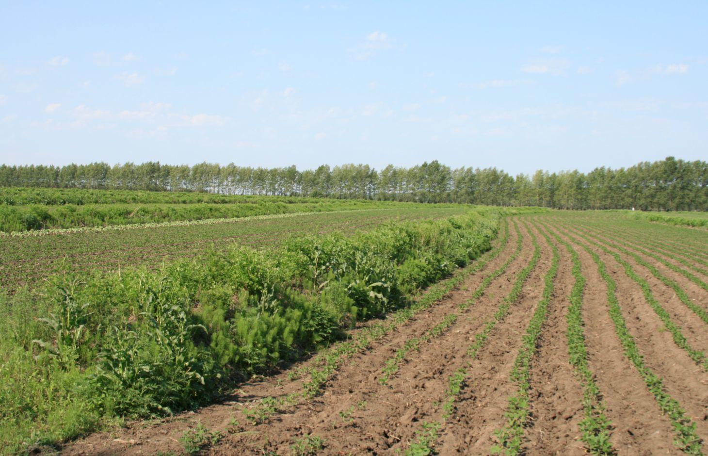
Belts of shrub or grass, planted on the level bund which constructed along contour line in gentle slope farmland in the black soil region of Northeast China.
2.2 การอธิบายแบบละเอียดของเทคโนโลยี
คำอธิบาย:
Shrubbery buffer strip with bund(SBSWB) is a traditional technology, it is introduced by the field staff about 60 years ago who worked in the farm in Heilongjiang province.This technology with low-cost, high effectives and easy to construct, which has been widely applied in all black soil region of Northeast China (Heilongjiang,Jilin,Liaoning,North of Inner Mongolia Autonomous Region).
Purpose of the Technology: The final purpose of these buffer strips is increasing crop production by decreasing soil loss. More specific objectives include: 1)protect the land from surface erosion by cutting slope length, increase infiltration and soil moisture; 2)to prevent soil loss of gentle slope farmland by allowing excess runoff to filter through but trapping sediment; 3) through the effect of tillage and water erosion between the strips, level bund lead to the formation of forward slope terraces over time, then developing into terrace final;4) creation of opportunities for additional income by harvesting fodder(grass) production and fruits(shrub).
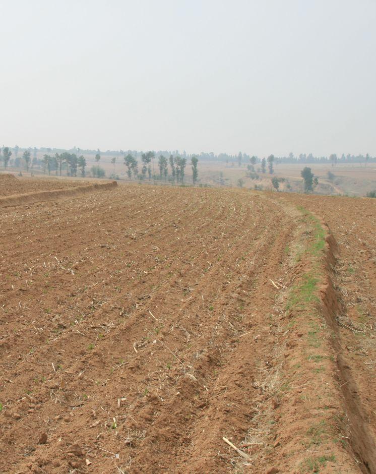
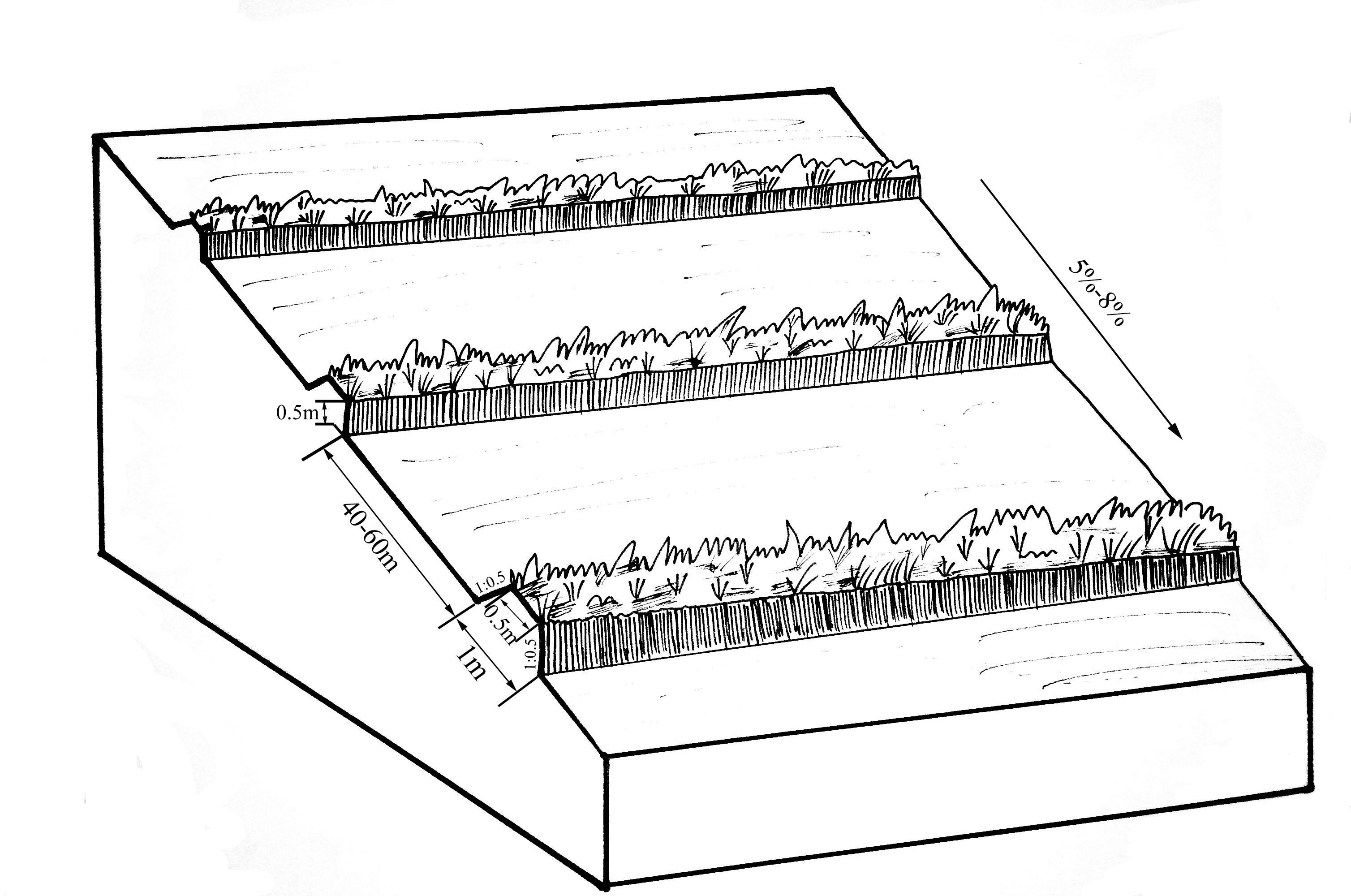
Establishment / maintenance activities and inputs: A construction is generally carried out in autumn of the year; plantation is made in spring of the next year. The construction in a man-machine integration mode is generally carried out step by step and from top to bottom along the contour line(s). The ladder-shaped cross section of a ridge is 0.3-0.5m in width (suitable width on the top), 0.5-0.6m in height, 1:1 or 1:0.5 in inner-side gradient and 1:0.5 in outer-side gradient.
In a construction, peel the surface soil with machine, with the peeling depth generally being 0.3m, which should be subject to soil layer depth; then haul the ridge construction plough (a kind of machine or device) with a tractor to build the ridges, consolidate the ridges through artificial slapping; Finally restore the surface soil to accomplish ridge construction. The tops of the constructed ridges should be maintained to be in a horizontal surface. The distance between two ridges in this region is generally stipulated to be 50 meters. The soil for ridge construction should be free from such sundries as gravels, tree roots and turfs.
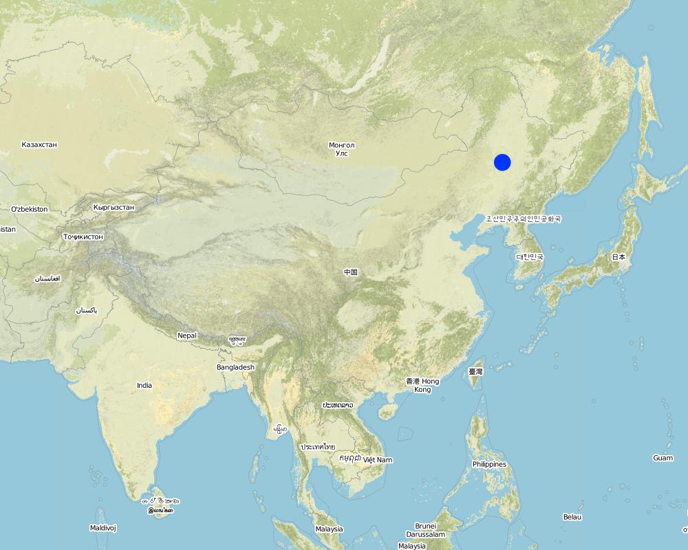
Natural / human environment: Shrubbery buffer strip is found mainly in Northeast China, at altitudes between 700 and 1600 m. Climate there is cold in winters and cool in summers, with a monsoon moisture regime. In the area, the annual mean temperatures is from 2 to 8 °C, and the annual mean precipitation is from 500 to 1000 mm. Most of the farmland slopes are less than 7°but slope lengths mainly range from 200 to 1000m in this area.
Northeast China, the grain production base of China, or the bread basket of China, includes three provinces (Hei-long-jiang, Ji-lin, and Liao-ning) and the eastern part of the Inner Mongolian autonomous region. In 2009, 17.1% the China’s total grain production came from this region, which included 33.5%, 55.7% and 9.6% of corn, soybean, and rice, respectively. Approximately 118 million people live in this region. Grain produced per capita is over 1000 kg annually.
2.3 รูปภาพของเทคโนโลยี
อัลบั้มสื่อบันทึก
2.5 ประเทศภูมิภาค หรือสถานที่ตั้งที่เทคโนโลยีได้นำไปใช้และได้รับการครอบคลุมโดยการประเมินนี้
ประเทศ:
จีน
ภูมิภาค/รัฐ/จังหวัด:
The black soil region of Northeast China
ข้อมูลจำเพาะเพิ่มเติมของสถานที่ตั้ง :
Heilongjiang,Jilin,Liaoning,North of Inner Mongolia Autonomous Region
ระบุการกระจายตัวของเทคโนโลยี:
- กระจายไปอย่างสม่ำเสมอในพื้นที่
If precise area is not known, indicate approximate area covered:
- > 10,000 ตร.กม.
แสดงความคิดเห็น:
This technique has been common applied in gentle slope farmland of the black soil region of Northeast China. It is very useful for reduce soil loss and intercept runoff.
Map
×2.6 วันที่การดำเนินการ
ถ้าไม่รู้ปีที่แน่นอน ให้ระบุวันที่โดยประมาณ:
- มากกว่า 50 ปี (แบบดั้งเดิม)
2.7 คำแนะนำของเทคโนโลยี
ให้ระบุว่าเทคโนโลยีถูกแนะนำเข้ามาอย่างไร:
- เป็นส่วนหนึ่งของระบบแบบดั้งเดิมที่ทำก้นอยู่ (> 50 ปี)
ความคิดเห็น (ประเภทของโครงการ เป็นต้น) :
SBSWB appear in the vicinity of Heilongjiang province in the last century 60's
3. การจัดประเภทของเทคโนโลยี SLM
3.2 ประเภทของการใช้ที่ดินในปัจจุบันที่ได้นำเทคโนโลยีไปใช้

พื้นที่ปลูกพืช
- การปลูกพืชล้มลุกอายุปีเดียว
Annual cropping - Specify crops:
- cereals - maize
- legumes and pulses - soya
- root/tuber crops - sugar beet
- rice
จำนวนของฤดูเพาะปลูกต่อปี:
- 1
ระบุ:
Longest growing period in days: 150Longest growing period from month to month: April to August
แสดงความคิดเห็น:
Main cash crop: soybean, sugarbeet
Main food crop: paddy rice, maize
Major land use problems (compiler’s opinion): Beacuse of long slope, high rainfall intensity, freezing and thawing processes, and intensive cultivation has lead to substantial water runoff, soil erosion, and gully formation. Soil erosion has been the serious problem threatening agriculture sustainability in the region for decades.The flora of the area are very diverse.
Major land use problems (land users’ perception): Soil fertility and crop yeild are decreasing year by year.
3.4 การใช้น้ำ
การใช้น้ำของที่ดินที่มีการใช้เทคโนโลยีอยู่:
- จากน้ำฝน
แสดงความคิดเห็น:
Water supply also mixed rainfed - irrigated
3.5 กลุ่ม SLM ที่ตรงกับเทคโนโลยีนี้
- มาตรการปลูกพืชขวางความลาดชัน (cross-slope measure)
3.6 มาตรการ SLM ที่ประกอบกันเป็นเทคโนโลยี

มาตรการอนุรักษ์ด้วยวิธีพืช
- V2: หญ้าและไม้ยืนต้น

มาตรการอนุรักษ์ด้วยโครงสร้าง
- S2: ทำนบ เขื่อนดิน
แสดงความคิดเห็น:
Main measures: vegetative measures, structural measures
Type of vegetative measures: aligned: -contour
3.7 รูปแบบหลักของการเสื่อมโทรมของที่ดินที่ได้รับการแก้ไขโดยเทคโนโลยี

การกัดกร่อนของดินโดยน้ำ
- Wt (Loss of topsoil): การสูญเสียดินชั้นบนหรือการกัดกร่อนที่ผิวดิน
- Wo (Offsite degradation): ผลกระทบนอกพื้นที่

การกัดกร่อนของดินโดยลม
- Et (Loss of topsoil): การสูญเสียดินชั้นบน
แสดงความคิดเห็น:
Main type of degradation addressed: Wt: loss of topsoil / surface erosion
Secondary types of degradation addressed: Wo: offsite degradation effects, Et: loss of topsoil
Main causes of degradation: soil management (The extensive cultivation and management modes reduce the thickness of black soil layer by 0.5 cm per year.), population pressure (Great population pressure makes the land carrying capacity decline year by year.), education, access to knowledge and support services (The channels for the local peasants with low levels of education to learn knowledge are few, and they will not take initiative to learn knowledge.)
Secondary causes of degradation: over-exploitation of vegetation for domestic use (This area is the most important grain production area in China, there is serious excessive exploitation in this area.), change of seasonal rainfall (The rainy seasons mainly focus on July and August.), Heavy / extreme rainfall (intensity/amounts) (The downpours in summer bring about soil loss.), land tenure (As the lands are owned by country or by peasant communities, the peasants are not strongly aware of the importance of land protection.), poverty / wealth (The serious gap between rich and poor)
3.8 การป้องกัน การลดลง หรือการฟื้นฟูความเสื่อมโทรมของที่ดิน
ระบุเป้าหมายของเทคโนโลยีกับความเสื่อมโทรมของที่ดิน:
- ป้องกันความเสื่อมโทรมของที่ดิน
- ลดความเสื่อมโทรมของดิน
แสดงความคิดเห็น:
Main goals: mitigation / reduction of land degradation
Secondary goals: prevention of land degradation
4. ข้อมูลจำเพาะด้านเทคนิค กิจกรรมการนำไปปฏิบัติใช้ ปัจจัยนำเข้า และค่าใช้จ่าย
4.1 แบบแปลนทางเทคนิคของเทคโนโลยี
ข้อมูลจำเพาะด้านเทคนิค (แบบแปลนทางเทคนิคของเทคโนโลยี):
The upper-base width, lower base width, height, slope ratio and spacing of a ridge are 0.5m, 1m, 0.5m, 1:0.5 and 40-60m respectively. A row spacing of the shrubs planted on the ridges should be 0.5m. Generally one row on each ridge is enough. About 80 shrubs are needed for every hectare; if herbaceous plants are planted, no special plantations are required.
Location: Chao Yang City. Liao Ning Province
Date: Nov 12,2012
Technical knowledge required for field staff / advisors: moderate (Field staff/agricultural advisor should have intermediate know-how level, because land user should be instructed by them)
Technical knowledge required for land users: low (The knowledge level of lander user is not required to be high, who just need(s) to follow the instructions from field staff/agricultural advisor)
Main technical functions: control of dispersed runoff: retain / trap, control of dispersed runoff: impede / retard, reduction of slope length, improvement of water quality, buffering / filtering water, sediment retention / trapping, sediment harvesting
Secondary technical functions: control of concentrated runoff: retain / trap, control of concentrated runoff: impede / retard, improvement of ground cover, improvement of topsoil structure (compaction), increase in organic matter, increase in nutrient availability (supply, recycling,…), increase of infiltration, increase / maintain water stored in soil, water harvesting / increase water supply, water spreading, increase of biomass (quantity), promotion of vegetation species and varieties (quality, eg palatable fodder), spatial arrangement and diversification of land use
Aligned: -contour
Vegetative material: F : fruit trees / shrubs
Number of plants per (ha): 200-600
Vertical interval between rows / strips / blocks (m): 5.644-8.466
Spacing between rows / strips / blocks (m): 40-60
Vertical interval within rows / strips / blocks (m): 0.5
Width within rows / strips / blocks (m): 0.5
Fruit trees / shrubs species: caragana, lespedeza, amorpha, daylily, Melilotus
Slope (which determines the spacing indicated above): 5-8%
Gradient along the rows / strips: 0%
Wall/ barrier
Vertical interval between structures (m): 2.09-5.55
Spacing between structures (m): 40-60
Height of bunds/banks/others (m): 0.3-0.5
Width of bunds/banks/others (m): 0.5-1
Length of bunds/banks/others (m): >100
Construction material (earth): The soil should be free from such sundries as gravels, tree roots and turfs.
Slope (which determines the spacing indicated above): 5-8%
Lateral gradient along the structure: 0%
ผู้เขียน:
Zhao Mei, Beijing Normal University, Beijing, China
4.2 ข้อมูลทั่วไปเกี่ยวกับการคำนวณปัจจัยนำเข้าและค่าใช้จ่าย
อื่นๆ หรือสกุลเงินประจำชาติ (ระบุ):
RMB
If relevant, indicate exchange rate from USD to local currency (e.g. 1 USD = 79.9 Brazilian Real): 1 USD =:
6.25
ระบุค่าเฉลี่ยของค่าจ้างในการจ้างแรงงานต่อวัน:
9.25
4.3 กิจกรรมเพื่อการจัดตั้ง
| กิจกรรม | Timing (season) | |
|---|---|---|
| 1. | Plant shrubbery | autumn |
| 2. | Layout of contour and the line of SBSWB with the leveling | autumn |
| 3. | Build the ridge | autumn |
4.4 ค่าใช้จ่ายของปัจจัยนำเข้าที่จำเป็นสำหรับการจัดตั้ง
| ปัจจัยนำเข้า | หน่วย | ปริมาณ | ค่าใช้จ่ายต่อหน่วย | ค่าใช้จ่ายทั้งหมดต่อปัจจัยนำเข้า | %ของค่าใช้จ่ายที่ก่อให้เกิดขึ้นโดยผู้ใช้ที่ดิน | |
|---|---|---|---|---|---|---|
| แรงงาน | Layout of contour | Person/day | 3.0 | 16.0 | 48.0 | |
| แรงงาน | Build ridge | Person/day | 36.0 | 9.6 | 345.6 | |
| อุปกรณ์ | Machine use | hours/day | 1.0 | 80.0 | 80.0 | |
| อุปกรณ์ | tools | day | 1.0 | 8.0 | 8.0 | |
| วัสดุด้านพืช | Seedling Plant shrubbery | ha | 600.0 | 0.016 | 9.6 | |
| ค่าใช้จ่ายทั้งหมดของการจัดตั้งเทคโนโลยี | 491.2 | |||||
| Total costs for establishment of the Technology in USD | 78.59 | |||||
แสดงความคิดเห็น:
Duration of establishment phase: 1 month(s)
4.5 การบำรุงรักษาสภาพหรือกิจกรรมที่เกิดขึ้นเป็นประจำ
| กิจกรรม | ช่วงระยะเวลา/ความถี่ | |
|---|---|---|
| 1. | The farmers will actively protect the Bund in their land. Don't need money. | autumn |
| 2. | The farmers will actively protect the Bund in their land. Don't need money. | autumn |
4.6 ค่าใช้จ่ายของปัจจัยนำเข้าและกิจกรรมที่เกิดขึ้นเป็นประจำที่ต้องการการบำรุงรักษา (ต่อปี)
แสดงความคิดเห็น:
Machinery/ tools: Spade, Spade
3 people are required to layout contour, daily labor cost for per person is 100 Yuan, so the total labor cost is 300Yuan ($48), tools fee is 50Yuan ($8).
One tractor can built 2.6 ha of ridges per day at a cost of 500 Yuan ($80). The ridges constructed should be artificially tamped, 120 people are needed to tamp the ridges in an area of 2.6ha, about 46 people for each hectare. As the daily labor cost for per person is 60 Yuan, the total expense on each hectare is 2760 Yuan($441.6), and the labor intensity is intermediate.
If shrubs are planted on the ridges, 400 shrubs are required for each 1 hectare management area. In addition, as the price of caragana microphylla in 2012 is 0.1 Yuan per one, the total cost of the caragana microphyllas per hectare should be 40Yuan($6.4).
Therefore, the total construction cost per hectare is 3650Yuan($584).
4.7 ปัจจัยสำคัญที่สุดที่มีผลกระทบต่อค่าใช้จ่าย
ปัจจัยสำคัญที่สุดที่มีผลกระทบต่อค่าใช้จ่ายต่างๆ:
The most determinate fators affecting the cost is labour
5. สิ่งแวดล้อมทางธรรมชาติและของมนุษย์
5.1 ภูมิอากาศ
ฝนประจำปี
- < 250 ม.ม.
- 251-500 ม.ม.
- 501-750 ม.ม.
- 751-1,000 ม.ม.
- 1,001-1,500 ม.ม.
- 1,501-2,000 ม.ม.
- 2,001-3,000 ม.ม.
- 3,001-4,000 ม.ม.
- > 4,000 ม.ม.
เขตภูมิอากาศเกษตร
- กึ่งชุ่มชื้น
- กึ่งแห้งแล้ง
Thermal climate class: temperate
Thermal climate class: boreal
5.2 สภาพภูมิประเทศ
ค่าเฉลี่ยความลาดชัน:
- ราบเรียบ (0-2%)
- ลาดที่ไม่ชัน (3-5%)
- ปานกลาง (6-10%)
- เป็นลูกคลื่น (11-15%)
- เป็นเนิน (16-30%)
- ชัน (31-60%)
- ชันมาก (>60%)
ธรณีสัณฐาน:
- ที่ราบสูง/ที่ราบ
- สันเขา
- ไหล่เขา
- ไหล่เนินเขา
- ตีนเนิน
- หุบเขา
ระดับความสูง:
- 0-100 เมตร
- 101-500 เมตร
- 501-1,000 เมตร
- 1,001-1,500 เมตร
- 1,501-2,000 เมตร
- 2,001-2,500 เมตร
- 2,501-3,000 เมตร
- 3,001-4,000 เมตร
- > 4,000 เมตร
5.3 ดิน
ค่าเฉลี่ยความลึกของดิน:
- ตื้นมาก (0-20 ซ.ม.)
- ตื้น (21-50 ซ.ม.)
- ลึกปานกลาง (51-80 ซ.ม.)
- ลึก (81-120 ซ.ม.)
- ลึกมาก (>120 ซ.ม.)
เนื้อดิน (ดินชั้นบน):
- ปานกลาง (ดินร่วน ทรายแป้ง)
อินทรียวัตถุในดิน:
- สูง (>3%)
- ปานกลาง (1-3%)
(ถ้ามี) ให้แนบคำอธิบายเรื่องดินแบบเต็มหรือระบุข้อมูลที่มีอยู่ เช่น ชนิดของดิน ค่า pH ของดินหรือความเป็นกรดของดิน ความสามารถในการแลกเปลี่ยนประจุบวก ไนโตรเจน ความเค็ม เป็นต้น:
Soil fertility: high
Soil drainage / infiltration: good
Soil water storage capacity: low - medium
5.4 ความเป็นประโยชน์และคุณภาพของน้ำ
ระดับน้ำใต้ดิน:
5-50 เมตร
น้ำไหลบ่าที่ผิวดิน:
ดี
คุณภาพน้ำ (ที่ยังไม่ได้บำบัด):
เป็นน้ำใช้เพื่อการเกษตรเท่านั้น (การชลประทาน)
5.5 ความหลากหลายทางชีวภาพ
ความหลากหลายทางชนิดพันธุ์:
- ปานกลาง
5.6 ลักษณะของผู้ใช้ที่ดินที่นำเทคโนโลยีไปปฏิบัติใช้
แนวทางการตลาดของระบบการผลิต:
- mixed (subsistence/ commercial)
รายได้ที่มาจากนอกฟาร์ม:
- > 50% ของรายได้ทั้งหมด
ระดับของความมั่งคั่งโดยเปรียบเทียบ:
- พอมีพอกิน
- รวย
เป็นรายบุคคล/ครัวเรือน:
- กลุ่ม/ชุมชน
ระดับของการใช้เครื่องจักรกล:
- งานที่ใช้แรงกาย
- การใช้เครื่องจักรหรือเครื่องยนต์
เพศ:
- หญิง
- ชาย
ระบุลักษณะอื่นๆที่เกี่ยวข้องของผู้ใช้ที่ดิน:
Land users applying the Technology are mainly common / average land users
Population density: 50-100 persons/km2
Annual population growth: < 0.5%
5% of the land users are very rich.
45% of the land users are rich.
35% of the land users are average wealthy.
15% of the land users are poor.
5% of the land users are poor.
5.7 Average area of land used by land users applying the Technology
- < 0.5 เฮกตาร์
- 0.5-1 เฮกตาร์
- 1-2 เฮกตาร์
- 2-5 เฮกตาร์
- 5-15 เฮกตาร์
- 15-50 เฮกตาร์
- 50-100 เฮกตาร์
- 100-500 เฮกตาร์
- 500-1,000 เฮกตาร์
- 1,000-10,000 เฮกตาร์
- >10,000 เฮกตาร์
พิจารณาว่าเป็นขนาดเล็ก กลาง หรือขนาดใหญ่ (ซึ่งอ้างอิงถึงบริบทระดับท้องถิ่น):
- ขนาดกลาง
5.8 กรรมสิทธิ์ในที่ดิน สิทธิในการใช้ที่ดินและสิทธิในการใช้น้ำ
กรรมสิทธิ์ในที่ดิน:
- เป็นแบบชุมชนหรือหมู่บ้าน
สิทธิในการใช้ที่ดิน:
- รายบุคคล
สิทธิในการใช้น้ำ:
- เกี่ยวกับชุมชน (ถูกจัดระเบียบ)
5.9 การเข้าถึงบริการและโครงสร้างพื้นฐาน
สุขภาพ:
- จน
- ปานกลาง
- ดี
การศึกษา:
- จน
- ปานกลาง
- ดี
ความช่วยเหลือทางด้านเทคนิค:
- จน
- ปานกลาง
- ดี
การจ้างงาน (เช่น ภายนอกฟาร์ม):
- จน
- ปานกลาง
- ดี
ตลาด:
- จน
- ปานกลาง
- ดี
พลังงาน:
- จน
- ปานกลาง
- ดี
ถนนและการขนส่ง:
- จน
- ปานกลาง
- ดี
น้ำดื่มและการสุขาภิบาล:
- จน
- ปานกลาง
- ดี
บริการด้านการเงิน:
- จน
- ปานกลาง
- ดี
6. ผลกระทบและสรุปคำบอกกล่าว
6.1 ผลกระทบในพื้นที่ดำเนินการ (On-site) จากการใช้เทคโนโลยี
ผลกระทบทางด้านเศรษฐกิจและสังคม
การผลิต
การผลิตพืชผล
การผลิตพืชที่ใช้เลี้ยงปศุสัตว์
คุณภาพพืชที่ใช้เลี้ยงปศุสัตว์
การผลิตสัตว์
การผลิตไม้
ความหลากหลายของผลิตภัณฑ์
พื้นที่สำหรับการผลิต
การจัดการที่ดิน
การผลิตพลังงาน
ความเป็นประโยชน์และคุณภาพของน้ำ
การมีน้ำดื่มไว้ให้ใช้
การมีน้ำไว้ให้ปศุสัตว์
คุณภาพน้ำสำหรับปศุสัตว์
การมีน้ำไว้ให้สำหรับการชลประทาน
คุณภาพน้ำสำหรับการชลประทาน
ความต้องการน้ำจากการชลประทาน
รายได้และค่าใช้จ่าย
ค่าใช่จ่ายของปัจจัยการผลิตทางการเกษตร
รายได้จากฟาร์ม
ความหลากหลายของแหล่งผลิตรายได้
ความเหลื่อมล้ำทางเศรษฐกิจ
ภาระงาน
ผลกระทบด้านสังคมวัฒนธรรมอื่น ๆ
โอกาสทางวัฒนธรรม
โอกาสทางด้านสันทนาการ
สถาบันของชุมชน
สถาบันแห่งชาติ
การบรรเทาความขัดแย้ง
Livelihoods and human well-being
ผลกระทบด้านนิเวศวิทยา
วัฐจักรน้ำหรือน้ำบ่า
ปริมาณน้ำ
คุณภาพน้ำ
การเก็บเกี่ยวหรือการกักเก็บน้ำ
น้ำไหลบ่าที่ผิวดิน
การระบายน้ำส่วนเกิน
น้ำบาดาลหรือระดับน้ำในแอ่งน้ำบาดาล
การระเหย
ดิน
ความชื้นในดิน
สิ่งปกคลุมดิน
การสูญเสียดิน
การเกิดแผ่นแข็งที่ผิวดิน /การเกิดชั้นดาน
การอัดแน่นของดิน
การหมุนเวียนและการเติมของธาตุอาหาร
ความเค็ม
อินทรียวัตถุในดิน/ต่ำกว่าดินชั้น C
ความหลากหลายทางชีวภาพของพืชและสัตว์
มวลชีวภาพ/เหนือดินชั้น C
ความหลากหลายทางชีวภาพของพืช
ความหลากหลายทางชีวภาพของสัตว์
ชนิดพันธุ์ที่ให้ประโยชน์
ลดความเสี่ยงของภัยพิบัติ
การปล่อยคาร์บอนและก๊าซเรือนกระจก
ความเร็วของลม
6.2 ผลกระทบนอกพื้นที่ดำเนินการ (Off-site) จากการใช้เทคโนโลยี
น้ำที่ใช้ประโยชน์ได้
การไหลของน้ำคงที่และสม่ำเสมอในช่วงฤดูแล้ง
น้ำท่วมพื้นที่ท้ายน้ำ
การทับถมของดินตะกอนพื้นที่ท้ายน้ำ
การเกิดมลพิษในน้ำบาดาลหรือแม่น้ำ
ความสามารถต้านทานการเปลี่ยนแปลง / ความสามารถในการคัดกรอง
ตะกอนที่ถูกพัดพามาโดยลม
ความเสียหายต่อพื้นที่เพาะปลูกของเพื่อนบ้าน
ความเสียหายต่อโครงสร้างพื้นฐานของรัฐหรือของเอกชน
6.3 การเผชิญและความตอบสนองของเทคโนโลยีต่อการเปลี่ยนแปลงสภาพภูมิอากาศที่ค่อยเป็นค่อยไป และสภาพรุนแรงของภูมิอากาศ / ภัยพิบัติ (ที่รับรู้ได้โดยผู้ใช้ที่ดิน)
การเปลี่ยนแปลงสภาพภูมิอากาศที่ค่อยเป็นค่อยไป
การเปลี่ยนแปลงสภาพภูมิอากาศที่ค่อยเป็นค่อยไป
| ฤดู | increase or decrease | เทคโนโลยีมีวิธีการรับมืออย่างไร | |
|---|---|---|---|
| อุณหภูมิประจำปี | เพิ่มขึ้น | ดี |
สภาพรุนแรงของภูมิอากาศ (ภัยพิบัติ)
ภัยพิบัติทางอุตุนิยมวิทยา
| เทคโนโลยีมีวิธีการรับมืออย่างไร | |
|---|---|
| พายุฝนประจำท้องถิ่น | ดี |
| พายุลมประจำท้องถิ่น | ดี |
ภัยพิบัติจากสภาพภูมิอากาศ
| เทคโนโลยีมีวิธีการรับมืออย่างไร | |
|---|---|
| ภัยจากฝนแล้ง | ดี |
ภัยพิบัติจากน้ำ
| เทคโนโลยีมีวิธีการรับมืออย่างไร | |
|---|---|
| น้ำท่วมตามปกติ (แม่น้ำ) | ดี |
ผลลัพธ์ตามมาที่เกี่ยวข้องกับภูมิอากาศอื่น ๆ
ผลลัพธ์ตามมาที่เกี่ยวข้องกับภูมิอากาศอื่น ๆ
| เทคโนโลยีมีวิธีการรับมืออย่างไร | |
|---|---|
| ช่วงการปลูกพืชที่ลดลงมา | ดี |
6.4 การวิเคราะห์ค่าใช้จ่ายและผลประโยชน์ที่ได้รับ
ผลประโยชน์ที่ได้รับเปรียบเทียบกับค่าใช้จ่ายในการจัดตั้งเป็นอย่างไร (จากมุมมองของผู้ใช้ที่ดิน)
ผลตอบแทนระยะสั้น:
ด้านลบเล็กน้อย
ผลตอบแทนระยะยาว:
ด้านบวก
ผลประโยชน์ที่ได้รับเปรียบเทียบกับค่าใช้จ่ายในการบำรุงรักษาหรือต้นทุนที่เกิดขึ้นซ้ำอีก เป็นอย่างไร (จากมุมมองของผู้ใช้ที่ดิน)
ผลตอบแทนระยะสั้น:
เป็นกลางหรือสมดุล
ผลตอบแทนระยะยาว:
ด้านบวกอย่างมาก
แสดงความคิดเห็น:
Although Certain quantity of land will be occupied and grain output will be affected in SBSWS during the early period of a construction, in the long run, SBSWS can prevent the loss of the most fertile surface soil, in addition, with the ever increased quantity of the sediment intercepted by SBSWS and as the heights of the vegetational belts increase year by year, the slope croplands will become bench terraces, and the grain output will be increased.
6.5 การปรับตัวของเทคโนโลยี
ถ้ามีข้อมูลให้บอกปริมาณด้วย (จำนวนของครัวเรือนหรือครอบคลุมพื้นที่):
NA
แสดงความคิดเห็น:
80% of land user families have adopted the Technology with external material support
Comments on acceptance with external material support: Large-area popularization of SBSWB has been achieved in the locality.
20% of land user families have adopted the Technology without any external material support
Comments on spontaneous adoption: The implementation of this measure was accomplished under the encouragement and support of the government. There are relatively few peasant households who initially take this measure. The main reason for the peasant reluctance to adopt this measure is that the ridges will occupy land and reduce arable area. They are unconscious of and do not care about soil loss, and unable to realize in the long run the harm brought about by soil loss.
There is a little trend towards spontaneous adoption of the Technology
Comments on adoption trend: The trend depands on government support
6.7 จุดแข็ง / ข้อได้เปรียบ / โอกาสของเทคโนโลยี
| จุดแข็ง / ข้อได้เปรียบ / โอกาสในทัศนคติของผู้ใช้ที่ดิน |
|---|
|
Convenient for construction How can they be sustained / enhanced? Popularization carried on |
| จุดแข็ง / ข้อได้เปรียบ / โอกาสในทัศนคติของผู้รวบรวมหรือวิทยากรหลัก |
|---|
|
Gradual formation of the slope-type terraces, which can be developed into bench terraces many years later How can they be sustained / enhanced? Increase of ridge height year by year |
|
Intercepting the sediments carried by runoffs, preventing water and soil loss of the arable lands on the gentle slopes How can they be sustained / enhanced? In combination with other water and soil conservation measures during operation, such as no-tillage and drainage ditches; |
|
increase of infiltration How can they be sustained / enhanced? Chopping down branches at regular intervals to guarantee that the plants on the ridges will not enter into rivary with the crops over water and sunlight; |
6.8 จุดอ่อน / ข้อเสียเปรียบ / ความเสี่ยงของเทคโนโลยีและวิธีการแก้ไข
| จุดอ่อน / ข้อเสียเปรียบ / ความเสี่ยงในทัศนคติของผู้ใช้ที่ดิน | มีวิธีการแก้ไขได้อย่างไร |
|---|---|
| The ridges occupy land and reduce arable area | government support |
| จุดอ่อน / ข้อเสียเปรียบ / ความเสี่ยงในทัศนคติของผู้รวบรวมหรือวิทยากรหลัก | มีวิธีการแก้ไขได้อย่างไร |
|---|---|
| Reduction of arable lands brings about low enthusiasm of the peasants | Conflict between the arable lands and the immediate interests of the peasants. Popularization of water and soil preservation knowledge should be strangthened to make the presants realize that although the immediate interests will be hurt, the long-term interests will increase. |
7. การอ้างอิงและการเชื่อมต่อ
7.1 วิธีการและแหล่งข้อมูล
7.2 การอ้างอิงถึงสิ่งตีพิมพ์
หัวข้อ, ผู้เขียน, ปี, หมายเลข ISBN:
Title:Techniques standard for comprehensive control of soil erosion in the black soil region Author:Shen bo; Meng lingqinYears:2009
ชื่อเรื่อง ผู้เขียน ปี ISBN:
internal materials
ลิงก์และโมดูล
ขยายทั้งหมด ย่อทั้งหมดลิงก์
ไม่มีลิงก์
โมดูล
ไม่มีโมดูล