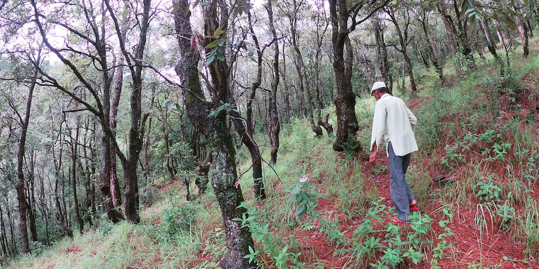
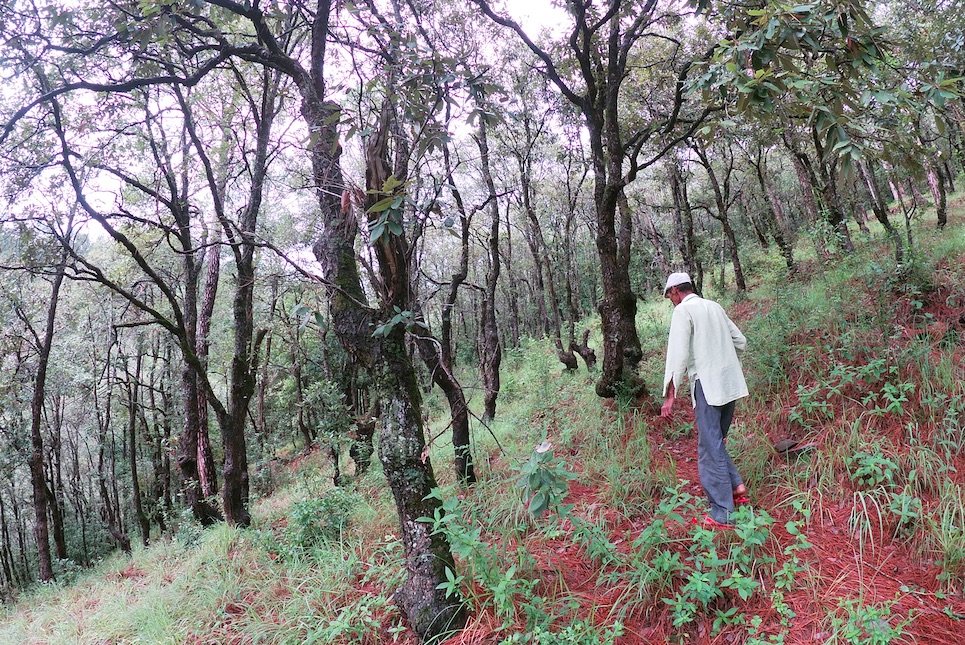
Broadleaf Plantations, Assisted Tree Regeneration and Fodder Nurseries for Sustainable Forest Management [ប្រទេសឥណ្ឌា]
- ការបង្កើត៖
- បច្ចុប្បន្នភាព
- អ្នកចងក្រង៖ Jaclyn Bandy
- អ្នកកែសម្រួល៖ –
- អ្នកត្រួតពិនិត្យ Hanspeter Liniger
Trees: Banj Oak (Quercus leucotricophora/glauca), Phalat (Quercus lanata), Fodder: Napier grasses, Bhimal (Grewia optiva), Khadik (Celtis australis)
technologies_5243 - ប្រទេសឥណ្ឌា
ពិនិត្យមើលគ្រប់ផ្នែក
ពង្រីកមើលទាំងអស់ បង្រួមទាំងអស់1. ព័ត៌មានទូទៅ
1.2 ព័ត៌មានលម្អិតពីបុគ្គលសំខាន់ៗ និងស្ថាប័នដែលចូលរួមក្នុងការវាយតម្លៃ និងចងក្រងឯកសារនៃបច្ចេកទេស
បុគ្គលសំខាន់ម្នាក់ (ច្រើននាក់)
អ្នកប្រើប្រាស់ដី:
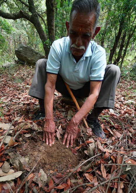
Joshi Jagdamba Prashad
Sarpanch (Head) of Nakina Community Forest (Van Panchayat)
ប្រទេសឥណ្ឌា
អ្នកប្រើប្រាស់ដី:
Pandey Basant Ballabh
Cucumber Farmer, Nakina Village
ប្រទេសឥណ្ឌា
ឈ្មោះគម្រោងដែលបានចងក្រងឯកសារ/ វាយតម្លៃលើបច្ចេកទេស (បើទាក់ទង)
Onsite and Offsite Benefits of SLMឈ្មោះអង្គភាពមួយ (ច្រើន) ដែលបានចងក្រងឯកសារ/ វាយតម្លៃបច្ចេកទេស (បើទាក់ទង)
ICIMOD International Centre for Integrated Mountain Development (ICIMOD) - ប្រទេសនេប៉ាល់ឈ្មោះអង្គភាពមួយ (ច្រើន) ដែលបានចងក្រងឯកសារ/ វាយតម្លៃបច្ចេកទេស (បើទាក់ទង)
G.B. Pant Institute of Himalayan Einvironment & Development (G.B. Pant Institute of Himalayan Einvironment & Development) - ប្រទេសឥណ្ឌា1.3 លក្ខខណ្ឌទាក់ទងទៅនឹងការប្រើប្រាស់ទិន្នន័យដែលបានចងក្រងតាមរយៈ វ៉ូខេត
អ្នកចងក្រង និង(បុគ្គលសំខាន់ៗ)យល់ព្រមទទួលយកនូវលក្ខខណ្ឌនានាទាក់ទងទៅនឹងការប្រើប្រាស់ទិន្នន័យដែលបានចងក្រងតាមរយៈវ៉ូខេត:
បាទ/ចា៎
1.4 សេចក្តីប្រកាសស្តីពីចីរភាពនៃការពណ៌នាពីបច្ចេកទេស
តើបច្ចេកទេសដែលបានពណ៌នានេះមានបញ្ហាដែលផ្តោតលើការធ្លាក់ចុះគុណភាពដី, បើដូច្នេះវាមិនអាចត្រូវបានប្រកាសថាជាបច្ចេកទេសនៃការគ្រប់គ្រងប្រកបដោយចីរភាពទេ?
ទេ
មតិយោបល់:
The land is suitable for afforestation and fodder nurseries. There are currently no signs of over exploitation with regards to natural resource use in the plantation area of the Nakina Forest.
1.5 ការយោងទៅលើកម្រងបញ្ជីសំណួរ (មួយ ឬច្រើន) នៃវិធីសាស្ត្រផ្សព្វផ្សាយ SLM (ដែលបានចងក្រងដោយទស្សនៈពិភពលោកស្តីពីវិធីសាស្ត្រ និងបច្ចេកទេសងអភិរក្ស WOCAT)

Community Forest Management in the Nakina Van Panchayat [ប្រទេសឥណ្ឌា]
Van Panchayats or village forest councils are a impressive example of grassroots community management of natural resources, where a specific administrative unit is locally elected by community members who are responsible for the management of activities related to the forest.
- អ្នកចងក្រង៖ Jaclyn Bandy
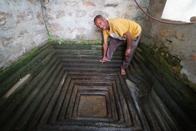
Naula Management and Conservation [ប្រទេសឥណ្ឌា]
Naulas are shallow, four-sided stepped wells designed to collect water from subterranean seepages or springs and are used to meet domestic water needs by the local communities. Naula management and conservation encompasses a range of activities that preserve their structure and function.
- អ្នកចងក្រង៖ Jaclyn Bandy
2. ការពណ៌នាពីបច្ចេកទេស SLM
2.1 ការពណ៌នាដោយសង្ខេបពីបច្ចេកទេស
និយមន័យបច្ចេកទេស:
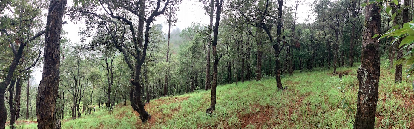
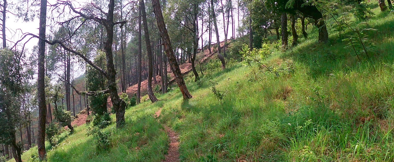
Natural assisted regeneration of broadleaved species, a small oak plantation and a fodder nursery have been established in the Nakina community forest (intervention area: 10 ha), supporting fodder tree species such as Banj Oak and Falyaat, as well as various subtropical temperate fodder grass species. This has improved the livelihood of the land-users by supporting the health and productivity of the forest, increasing the availability of fuel wood, fodder and groundwater for spring restoration.
2.2 ការពណ៌នាលម្អិតពីបច្ចេកទេស
ការពណ៌នា:
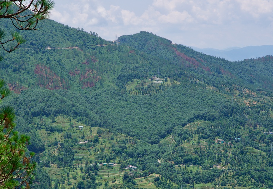
1. The technology is applied in a natural environment and is located about 1km away from the settlement and the agriculture land of Nakina Village. The village has access to its own forest, which covers a geographical area of 114 hectare. Of this, 94 hectares come under the Village Forest Council, locally referred to as the Van Panchayat.
2. Characteristics of Technology:
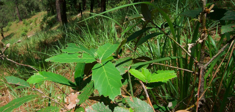
a. Broadleaf species have been established over 7 hectares through natural assisted tree regeneration methods. These include Banj Oak (Quercus leucotrichophora), Falyaat (Quercus glauca), Koeraal (Bauhinia verigata), Bhimal (Grewia optiva), Padam Paaya (Prunus cerasoides), Haradh (Terminalia chebula), Reetha (Sapindus Mukorossi), Utees (Alnus napalensis), Ainyar (Lyonia ovalifolia), Khadik (Celtis australis).
b. Nakina Van Panchayat has made an oak plantation site of 2 hectares in collaboration with G.B. Pant Research Institute.
c. A fodder nursery covering 1 hectare hosts a variety of subtropical (Napier: Pennisetum purpureum, Aus, Ginni) and temperate grasses (Guchhi, Dolni, Italian rye: Lolium multiflorum). It was established with the assistance of the NGOs Swati Gramodyog Sansthan and the Himalayan Sewa Samiti. Extraction of fodder leaves and timber are restricted and regulations managed by the Van Panchayat (community forest council).
Purposes/functions:
-Increase trees and grasses to improve availability of fuel and fodder for community, as well as enrich biodiversity.
-Plantation is on a mountain slope (+25% slope), so it will help in preventing soil erosion and landslides.
-Improve soil and water conservation, prevention of surface run-off, support groundwater recharge and spring rejuvenation.
Major activities/Inputs needed to establish and maintain technology:
1. Activities for Assisted Natural Regeneration: protect and facilitate the growth of parent trees inherently present in the area and their regenerations, rather than establishment of entire plantation
2.Activities for the oak plantation: Selection and seed provision of appropriate tree species, clearing of vegetation and preparation of forest top soil, leveling of soil, digging of plantation pits, sowing weeding, watering, occasional pruning, propagation of trees from cuttings, dead sapling replacement, establishment of barrier/fencing for protection from fire.
3. Activities for fodder nursery:- Selection and seed provision of appropriate grass species and polypot materials, preparation of seedbeds; clearing of vegetation, removal of stones/large roots, ploughing/hoeing, mixing sand and compost on areas with poor soil, sowing seeds pre-monsoon, weeding and watering seedlings, propagation from seed or root cuttings, dead sapling replacement, establishment of barrier/fencing protection from fire.
Benefits/Impacts:
•Restores productivity and fodder/fuelwood availability
•Ecosystem stability
•Enhancement of biological diversity to degraded lands.
•Control landslide and soil erosion
•Control forest fire.
•Maintain wildlife habitat
•Increase livelihood of local people, decrease time spent collecting fodder
•Storage carbon on the forest help to reduce the CO2 in the atmosphere.
Likes:
This technology is properly functioning in the implementation area and local people have received many benefits from sustainable managing their natural resources rather than receiving incentives for institutional support, local people of the Nakina village are strongly active to protect the forest with their own coordination.
Dislikes:
1.Improve wildlife habitat, which may increase human wildlife conflicts as it is near to agriculture land and settlements.
2.Require regular maintenance activities, which require organization within the community and can increase periodic workload depending on level of participation
2.3 រូបភាពនៃបច្ចេកទេស
វិចិត្រសាលប្រព័ន្ធផ្សព្វផ្សាយ
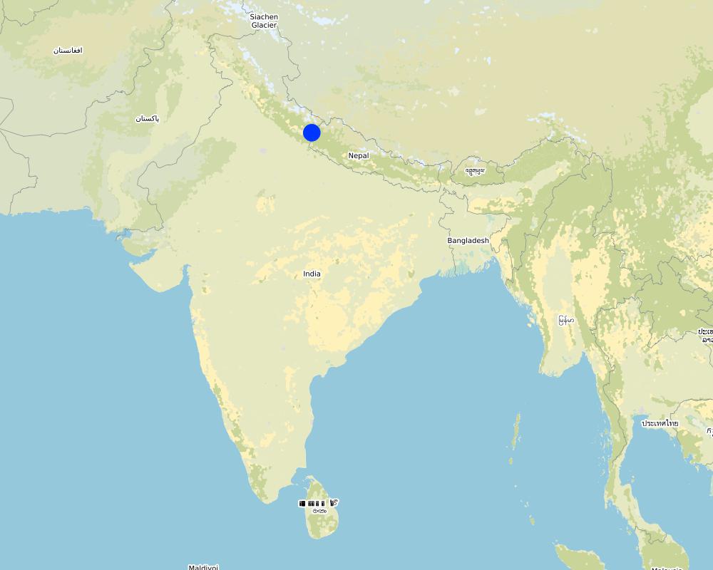
2.5 ប្រទេស/តំបន់/ទីតាំងកន្លែង ដែលបច្ចេកទេសត្រូវបានអនុវត្ត និងបានគ្រប់ដណ្តប់ដោយការវាយតម្លៃនេះ
ប្រទេស:
ប្រទេសឥណ្ឌា
តំបន់/រដ្ឋ/ខេត្ត:
Uttarakhand
បញ្ជាក់បន្ថែមពីលក្ខណៈនៃទីតាំង:
Nakina Village, Pithoragarh Bloc
បញ្ជាក់ពីការសាយភាយនៃបច្ចេកទេស:
- អនុវត្តនៅកន្លែងជាក់លាក់មួយ/ ប្រមូលផ្តុំនៅតំបន់តូចៗ
តើបច្ចេកទេស (មួយ ឬច្រើន) ទាំងនោះស្ថិតនៅក្នុងតំបន់ការពារជាអចិន្ត្រៃយ៍ណាមួយដែរឬទេ?
បាទ/ចា៎
បើបាទ/ច៎ា សូមបញ្ជាក់:
Nakina Van Panchayat (community forest)
Map
×2.6 កាលបរិច្ឆេទនៃការអនុវត្ត
ប្រសិនបើមិនច្បាស់ឆ្នាំ សូមបញ្ជាក់កាលបរិច្ឆេទដែលប្រហាក់ប្រហែល:
- 10-50 ឆ្នាំ
2.7 ការណែនាំពីបច្ចេកទេស
សូមបញ្ជាក់តើបច្ចេកទេសត្រូវបានណែនាំឱ្យអនុវត្តដោយរបៀបណា:
- តាមរយៈការបង្កើតថ្មីរបស់អ្នកប្រើប្រាស់ដី
- តាមរយៈគម្រោង / អន្តរាគមន៍ពីខាងក្រៅ
មតិយោបល់ (ប្រភេទនៃគម្រោង ។ល។):
After the Nakina Van Panchyat was established in 1952 they already had experience working on plantations. During the British-era, timber extraction, pine plantations and prescribed fire exploded in the region. Much of the oak forests were reverted to pine, and many broadleaved species like were overexploited for construction, fuelwood, and fodder. Nakina's self-initiated plantation efforts were done in hopes to restore it to its original state.
Other supporting organizations and institutions have recognized the need for further support for the following reasons: demand for fuel and fodder is still insufficient during the dry season, water scarcity has become a prevalent issue, and biological interventions are necessary to improve and sustain ecosystem services. Due to the expressed interest and dedication of the community, these projects have been accomplished.
3. ចំណាត់ថ្នាក់នៃបច្ចេកទេស SLM
3.1 គោលបំណងចម្បង (១ ឬច្រើន) នៃបច្ចេកទេសនេះ
- ធ្វើឱ្យប្រសើរឡើងនូវផលិតកម្ម
- កាត់បន្ថយ, បង្ការ, ស្តារឡើងវិញនូវការធ្លាក់ចុះគុណភាពដី
- អភិរក្សប្រព័ន្ធអេកូឡូស៊ី
- ការពារតំបន់ទីជម្រាល/តំបន់ខ្សែទឹកខាងក្រោមបញ្ចូលជាមួយបច្ចេកទេសផ្សេងទៀត
- អភិរក្ស/ធ្វើឱ្យប្រសើរឡើងជីវចម្រុះ
- កាត់បន្ថយហានិភ័យនៃគ្រោះមហន្តរាយ
- បន្ស៊ាំទៅនឹងការប្រែប្រួលអាកាសធាតុ/គ្រោះមហន្តរាយ និងផលប៉ះពាល់របស់វា
- បង្កើតផលប្រយោជន៍សេដ្ឋកិច្ច
3.2 ប្រភេទដីប្រើប្រាស់មួយប្រភេទ (ច្រើនប្រភេទ) ដែលបានអនុវត្តបច្ចេកទេស
ដីប្រើប្រាស់ចម្រុះនៅលើដីតែមួយ:
បាទ/ចា៎

ដីសម្រាប់ចិញ្ចឹមសត្វ
ដីវាលស្មៅតូចៗ/ ផលិតកម្មចំណី:
- កាត់ និងជញ្ជូន/ គ្មានវាលស្មៅសម្រាប់ចិញ្ចឹមសត្វ
ប្រភេទសត្វ:
- សត្វពាហនៈ - សត្វចិញ្ចឹមយកទឹកដោះ
- សត្វពពែ
តើជាការអនុវត្តការគ្រប់គ្រងដែលរួមបញ្ចូលការដាំដំណាំ និងចិញ្ចឹមសត្វដែរឬទេ?
បាទ/ចា៎
បើបាទ/ច៎ា សូមបញ្ជាក់:
Compost was made from manure of livestock for plantation and fodder nursery preparation.
ផលិតផល និងសេវាកម្ម:
- សាច់
- ទឹកដោះគោ

ដីព្រៃ/ដីដាំដើមឈើ
- ព្រៃ (ពាក់កណ្តាល) ធម្មជាតិ/ ដីព្រៃ
- ការដាំដើមឈើ ការដាំព្រៃឡើងវិញ
ព្រៃ (ពាក់កណ្តាល) ធម្មជាតិ / ដីព្រៃ៖ បញ្ជាក់ប្រភេទនៃការគ្រប់គ្រង:
- កាប់តែមួយចំនួន
ប្រភេទព្រៃ (ពាក់កណ្តាល) ធម្មជាតិ:
- សារពើរុក្ខជាតិនៃព្រៃស្ងួតធម្មជាតិតំបន់ពាក់កណ្តាលត្រូពិច
ការដាំដើមឈើ ការដាំដើមឈើឡើងវិញ៖ បញ្ជាក់ពីប្រភេទក្នុងតំបន់ និងប្រភេទលុប:
- ពូជបញ្ចូលគ្នា
ប្រភេទដើមឈើដែលដាំនៅកន្លែងដែលមិនធ្លាប់មានឈើពីមុន :
- ព្រៃស្ងួតដាំតំបន់ពាក់កណ្តាលត្រូពិច - ឈើស្លឹកធំ
- Banj Oak (Quercus leucotricophora), Falyaat (Quercus glauca), Koeraal (Bauhinia verigata), Bhimal (Grewia optiva), Padam Paaya (Prunus cerasoides), Haradh (Terminalia chebula), Reetha (Sapindus Mukorossi), Utees (Alnus napalensis), Ainyar (Lyonia ovalifolia)
តើប្រភេទឈើខាងលើជាប្រភេទឈើក្នុងព្រៃល្បោះ ឬស្រោង?
- ព្រៃល្បោះ
ផលិតផល និងសេវាកម្ម:
- ឈើហ៊ុប
- អុស
- ផលិតផលព្រៃផ្សេងៗ
- វាលស្មៅ
- ការអភិរក្ស/ការការពារធម្មជាតិ
3.3 បន្ទាប់ពីអនុវត្តបច្ចេកទេស តើដីប្រើប្រាស់មានការប្រែប្រួលដែររឺទេ?
បន្ទាប់ពីអនុវត្តបច្ចេកទេស តើដីប្រើប្រាស់មានការប្រែប្រួលដែររឺទេ?
- ទេ (បន្តទៅសំណួរ 3.4)
3.4 ការផ្គត់ផ្គង់ទឹក
ការផ្គត់ផ្គង់ទឹកនៅកន្លែងអនុវត្តបច្ចេកទេស:
- ទឹកភ្លៀង
3.5 ក្រុម SLM ដែលបច្ចេកទេសស្ថិតនៅក្នុង
- ការគ្រប់គ្រងព្រៃធម្មជាតិ និងព្រៃពាក់កណ្តាលធម្មជាតិ
- គ្រប់គ្រងការដាំព្រៃឈើ
- ធ្វើឱ្យប្រសើរឡើងគម្របដី/ ដំណាំគម្របដី
3.6 វិធានការ SLM ដែលបញ្ចូលនូវបច្ចេកទេស

វិធានការរុក្ខជាតិ
- V1: ឈើធំៗ និងដើមឈើតូចៗ
- V2: ស្មៅនិងរុក្ខជាតិៗដែលដុះមានអាយុមិនលើសពី 2ឆ្នាំ
- V3: ការកាប់ឆ្ការរុក្ខជាតិ
- V4: ការជំនួស ឬការយកចេញនៃប្រភេទរុក្ខជាតិក្រៅស្រុក/ ការរាតត្បាត
- V5: ផ្សេងៗ

វិធានការគ្រប់គ្រង
- M1: ការផ្លាស់ប្តូរប្រភេទដីប្រើប្រាស់
- M2: ការផ្លាស់ប្តូរការគ្រប់គ្រង/ កម្រិតអាំងតង់ស៊ីតេ
- M3: ប្លង់យោងទៅតាមធម្មជាតិ និងបរិស្ថានធម្មជាតិ
- M5: គ្រប់គ្រង/ ការប្លាស់ប្តូរសមាសភាពពូជ
3.7 កំណត់ប្រភេទនៃការធ្លាក់ចុះគុណភាពដីសំខាន់ៗដែលបច្ចេកទេសនេះបានដោះស្រាយ

ការហូរច្រោះដីដោយសារទឹក
- Wt: ការបាត់ដីស្រទាប់លើដោយការហូរច្រោះ
- Wg: ការកកើតឡើងនូវកំទេចកំទីដីស្រទាប់ក្រោម
- Wm: ការបាក់ដី
- Wo: ផលប៉ះពាល់នៃការធ្លាក់ចុះគុណភាពកន្លែងឆ្ងាយ

ការធ្លាក់ចុះសារធាតុគីមីក្នុងដី
- Cn: ការថយចុះជីជាតិ និងកាត់បន្ថយបរិមាណសារធាតុសរីរាង្គ (មិនកើតឡើងដោយការហូរច្រោះទេ)
- Ca: អាស៊ីតកម្ម

ការបាត់បង់រូបសាស្ត្រនៃដី
- Pc: ការហាប់ណែន
- Pk: ការបិទរន្ធដី
- Pi: ការគ្របផ្ទៃដី
- Pu: បាត់បង់នូវផលិតភាពជីវៈដោយសារសកម្មភាពផ្សេងៗ

ការធ្លាក់ចុះជីវសាស្ត្រនៃដី
- Bc: ការថយចុះនូវគម្របរុក្ខជាតិ
- Bh: ការបាត់បង់ទីជំរក
- Bq: ការថយចុះនូវជីវម៉ាស/ បរិមាណ
- Bf: ផលប៉ះពាល់ដែលបណ្តាលមកពីភ្លើងឆេះ
- Bs: សមាសភាពដែលមានគុណភាពនិងប្រភេទសត្វ/ការថយចុះនូវជីវចម្រុះ
- Bl: ការបាត់បង់មីក្រូ និងម៉ាក្រូសរីរាង្គរបស់ដី
- Bp: ការកើនឡើងនូវសត្វល្អិត ឬជំងឺ បាត់បង់នូវសត្វមានប្រយោជន៍

ការបាត់បង់ទឹក
- Ha: ការថយចុះសំណើមដី
- Hs: ការប្រែប្រួលបរិមាណទឹកនៅលើផ្ទៃដី
- Hg: ការប្រែប្រួលបរិមាណទឹកនៅក្រោមដី
- Hp: ការថយចុះគុណភាពទឹកនៅលើផ្ទៃដី
- Hq: ការថយចុះគុណភាពទឹកនៅក្រោមដី
3.8 ការពារ កាត់បន្ថយ ឬស្តារឡើងវិញនៃការធ្លាក់ចុះគុណភាពដី
បញ្ជាក់ពីគោលដៅរបស់បច្ចេកទេស ដែលផ្តោតទៅការធ្លាក់ចុះគុណភាពដី:
- ការកាត់បន្ថយការធ្លាក់ចុះគុណភាពដី
- ការជួសជុល/ ស្តារឡើងវិញនៃឱនភាពដីធ្ងន់ធ្ងរ
4. បច្ចេកទេសជាក់លាក់ សកម្មភាពអនុវត្ត ធាតុចូល និងថ្លៃដើម
4.1 គំនូសបច្ចេកទេសនៃបច្ចេកទេសនេះ
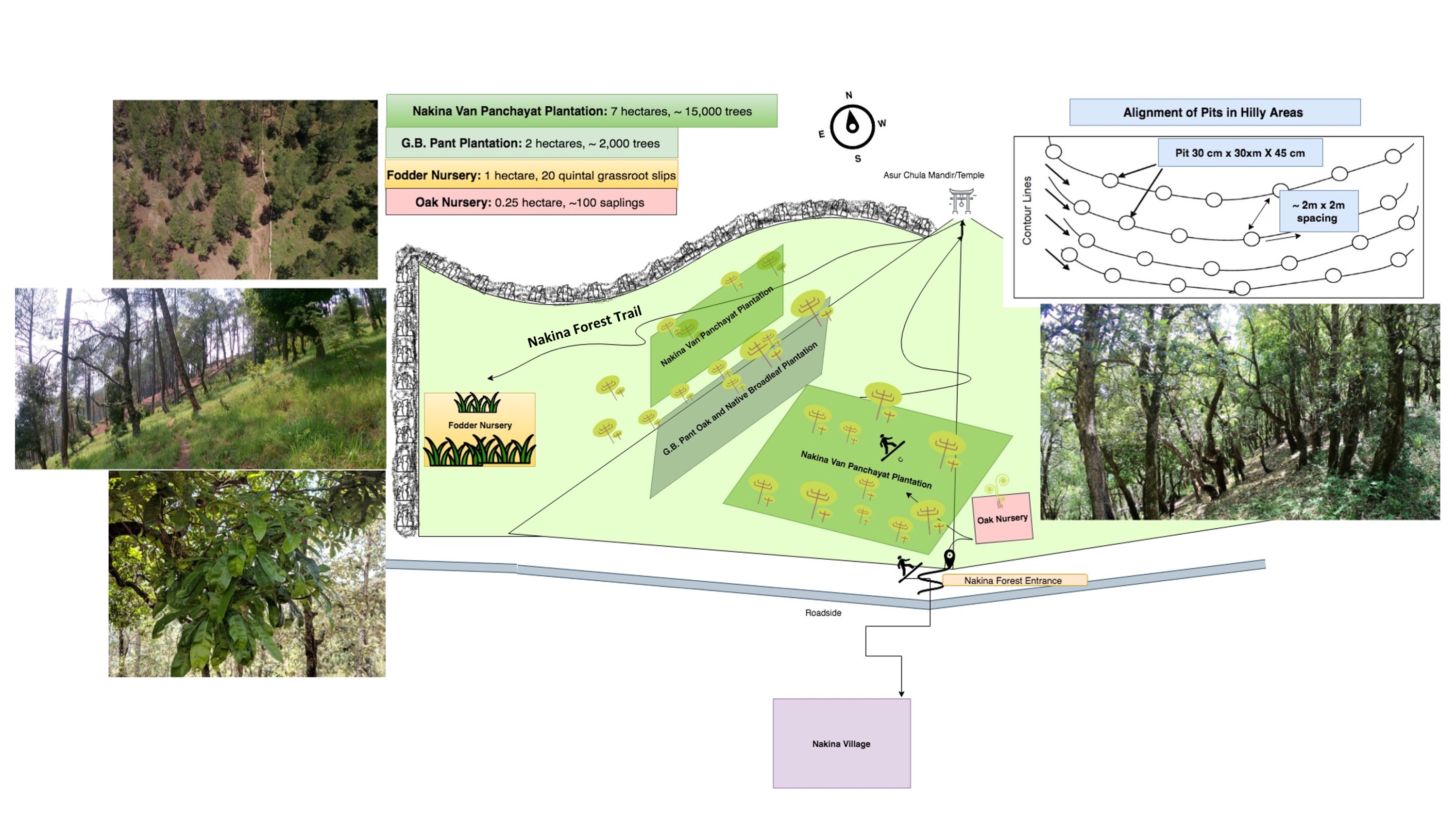
លក្ខណៈពិសេសនៃបច្ចេកទេស (ទាក់ទងនឺងគំនូរបច្ចេកទេស):
G.B. Pant Plantation: 2 Hectare, pits of (30 cm X 30cm X 45cm) were dug along contour lines, spacing of pits is not less than 2x2 m, about 2,000 Quercus saplings were planted.
Nakina Broadleaf Plantation: 7 Hectare, pits of (30 cm X 30cm X 45cm) were dug along contour lines, spacing of pits is no less that 2x2 m, about 15,000 trees have been planted and the forest is being continually managed in the area.
Species: Banj Oak (Quercus leucotrichophora), Falyaat (Quercus glauca), Koeraal (Bauhinia verigata), Bhimal (Grewia optiva), Padam Paaya (Prunus cerasoides), Haradh (Terminalia chebula), Reetha (Sapindus Mukorossi), Utees (Alnus napalensis), Ainyar (Lyonia ovalifolia), Khadik (Celtis australis)
Fuelwood cutting (lopping), fodder collection, and selective clear cutting for Quercus leucotrichophora and other broadleaved species is done between Nov- April.
Fodder Nursery: 20 Quintals (20,000 kg) of various grassroot slips over 1 Hectare. This provides +175 tonnes/year. (Subtropicals species: napier, aus, ginni, Temperate species: guchhi, dolni, italian rye)
Planting: Grasses are planted during the months of June-July at the advent of rainy season, about 10 cm deep vertically and at a spacing of 45 x 30 cm apart.
Propagation: grasses forms clumps during its growth period. The clump when broken gives a number of small units known as slips, which are the units of propagation and on planting, they establish as individual plants. While preparing the slips for planting, fibrous roots and leaves are be trimmed off. Cuttings with 2 nodes from the middle portion of moderately matured stems (3 – 4 months old) were planted in a slanting position at one side of the ridges with one node buried in the soil. The underground node develops roots and shoots while the upper node shoots only. The soil around the stem is pressed tightly. Farm yard manure is applied after harvest (application rate varies; estimation is 5-8 tonnes). Annually about 6 to 8 cuts are possible.
Oak Nursery: 0.25 ha. The nursery bed is rectangular and measures about 100m x 25 m. The seedlings are uprooted by hand from a seedbed and transplanted (bare-root transplanting). The nursery is on a gently sloping land (23%). Seedlings with poor lateral root development are culled out.
Oak Plantation Alternative:
Acorns are collected and put in water for 24 hours. Acorns that sink are immediately sown in a well tilled seedbed 2-5 cm deep, 15 cm from each other and covered with a thin layer of firm soil. Beds are mulched with straw or leaves. However, not every acorn will germinate and animal predation of acorns can be an issue. In general, probability of success is lower than with seedlings.
ឈ្មោះអ្នកនិពន្ធ:
Jaclyn Bandy
កាលបរិច្ឆេទ:
25/07/2019
លក្ខណៈពិសេសនៃបច្ចេកទេស (ទាក់ទងនឺងគំនូរបច្ចេកទេស):
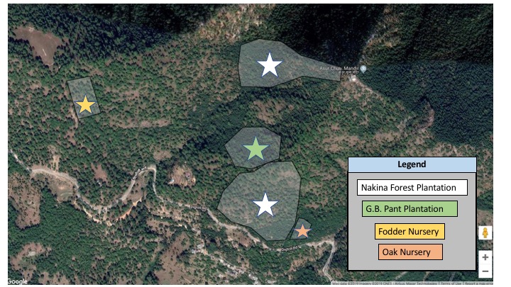
Google Map of Plantations and Fodder Nursery locations
ឈ្មោះអ្នកនិពន្ធ:
Jaclyn Bandy
កាលបរិច្ឆេទ:
25/07/2019
លក្ខណៈពិសេសនៃបច្ចេកទេស (ទាក់ទងនឺងគំនូរបច្ចេកទេស):
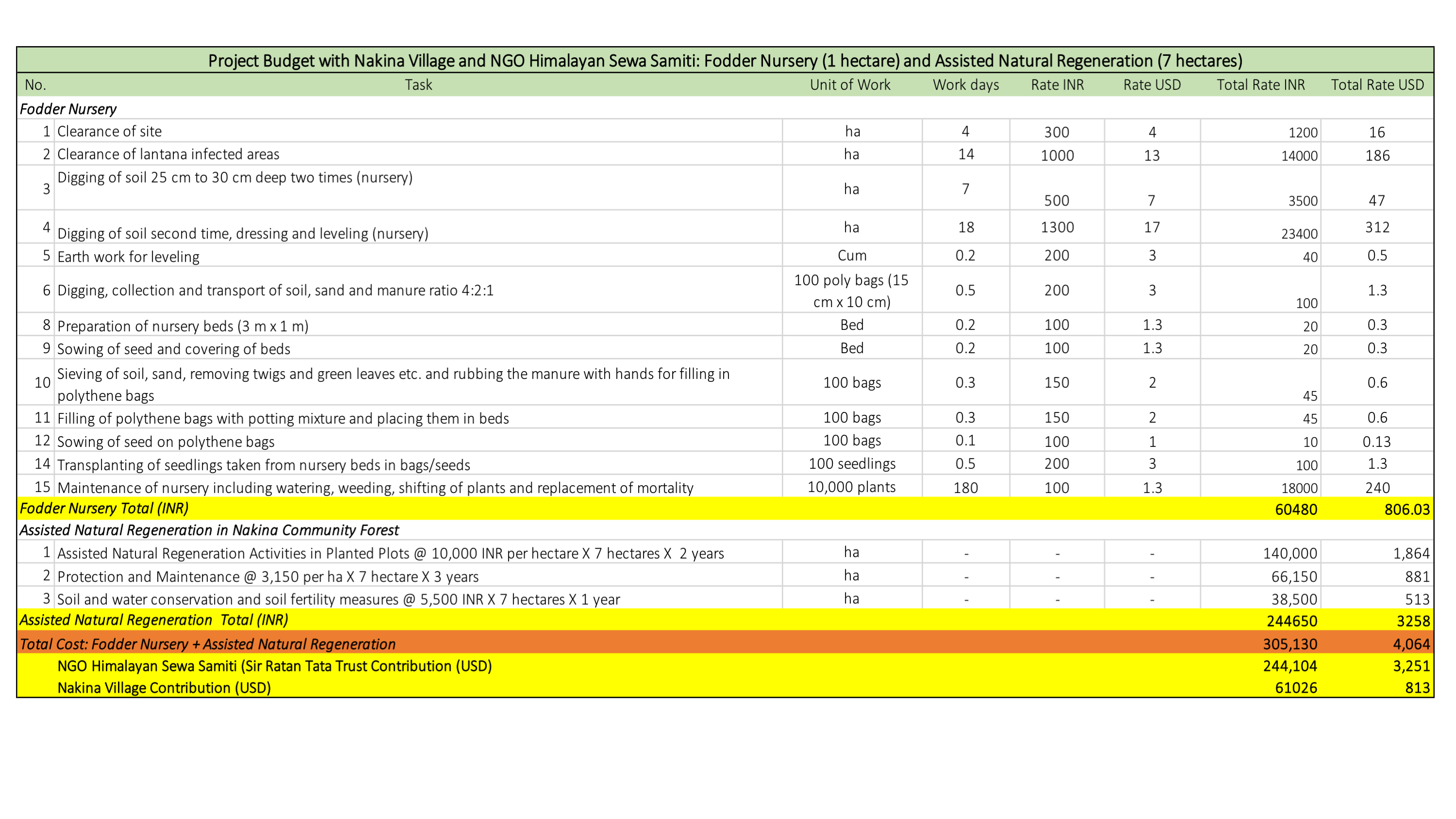
Project Budget with Nakina Village and NGO Himalayan Sewa Samiti: Fodder Nursery, 1 hectare and Assisted Natural Regeneration 97 Hectares)
(Citation: Detailed Project Report: Natural Resource Based Livelihood Project in the Gorang Ghati Cluster, NGO Himalayan Sewa Samiti, Submitted to: Sir Ratan Tata Trust (SRTT) Forest Works Manual, 2015 Forest Research Institute, Dehradun, Uttarakhand)
ឈ្មោះអ្នកនិពន្ធ:
J Bandy
លក្ខណៈពិសេសនៃបច្ចេកទេស (ទាក់ទងនឺងគំនូរបច្ចេកទេស):
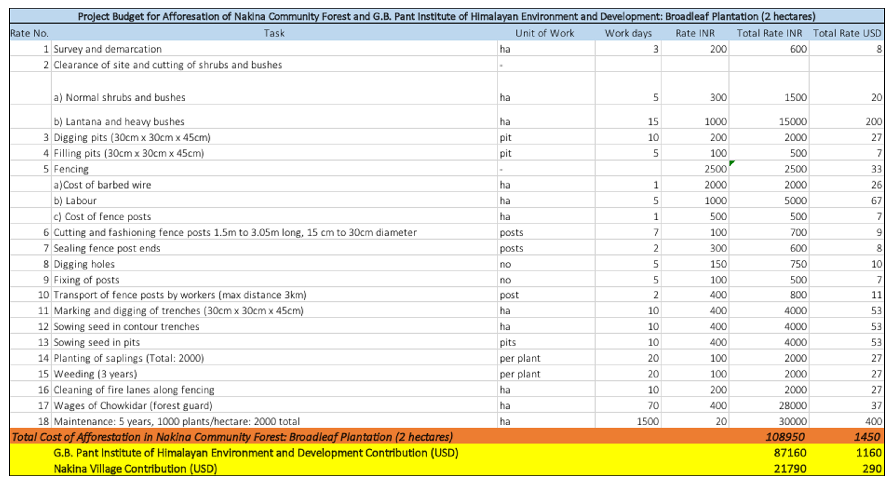
Project Budget for Afforestation of Nakina Community Forest and G.B. Pant Institute of Himalayan Environment and Development: Broadleaf Plantation (2 hectares)
(Citation: Forest Works Manual, 2015 Forest Research Institute, Dehradun, Uttarakhand)
ឈ្មោះអ្នកនិពន្ធ:
J Bandy
4.2 ព័ត៌មានទូទៅដែលពាក់ព័ន្ធនឹងការគណនាធាតុចូល និងថ្លៃដើម
កំណត់របៀបនៃការគណនាថ្លៃដើម និងធាតុចូល:
- ក្នុងតំបន់អនុវត្តបច្ចេកទេស
កំណត់ទំហំ និងឯកត្តាផ្ទៃដី:
Afforested Community Forest: 7 hectares, G.B. Pant Plantation: 2 hectares, Fodder Nursery: 1 hectare
ផ្សេងៗ/ រូបិយប័ណ្ណជាតិ (បញ្ជាក់):
INR
បើពាក់ព័ន្ធសូមកំណត់អត្រាប្តូរប្រាក់ពីដុល្លាទៅរូបិយប័ណ្ណតំបន់ (ឧ. 1 ដុល្លារ = 79.9 រៀលនៃរូបិយប័ណ្ណប្រេស៊ីល) ៖ 1 ដុល្លារ =:
70,0
កំណត់ថ្លៃឈ្នួលជាមធ្យមនៃការជួលកម្លាំងពលកម្មក្នុងមួយថ្ងៃ:
400 INR
4.3 សកម្មភាពបង្កើត
| សកម្មភាព | រយៈពេល (រដូវកាល) | |
|---|---|---|
| 1. | Plantations: Survey, demarcation, clearance of shrubs, bushes, Lantana (invasive species) | Pre-monsoon |
| 2. | Earth work for leveling, Digging pits (30 cm X 30cm X 45cm) along contour lines, spacing of pits no less that 2x2 m, filling of pits with soil/manure mixture | Early June |
| 3. | Planting of saplings: roots of the plants kept straight and the plant put straight in vertical position; done by digging with the help of a stick or small crow bar | Early July |
| 4. | Note: Species like Akhrot, Angu, Maple, Pangar, Poplar, Salix, Utis etc. are planted in winter months | January/February |
| 5. | Dead, dying or dry plants are replaced within 15 days of completion of planting work | Mid June |
| 6. | Thanwalas (semicircular pit) about 15 cm deep, 25-30 cm apart from the plant were dug for rainwater retention/infiltration | Mid June |
| 7. | Weeding after first significant rains | Monsoon |
| 8. | Fodder Nursery: Survey, demarcation, clearance of shrubs, bushes, Lantana (invasive species) | Pre-monsoon |
| 9. | Plowing/hoeing land, collection and soil, sand, manure preparation (4:2:1 ratio) and seedbed preparation | Pre-monsoon |
| 10. | Planting of each cane/rootsplit in holes 15-30 cm deep, with a spacing of 0.5m x 0.5m | Pre-monsoon |
| 11. | Cutting and Harvesting |
មតិយោបល់:
Oak Plantation: Seeds are collected from dominant oak trees that exhibit superior phenotypic traits such as tall straight trunks, good diameter growth rates and well-developed crowns (branches/leaves)
Cuttings:
4.4 ថ្លៃដើម និងធាតុចូលដែលត្រូវការសម្រាប់ការបង្កើតបច្ចេកទេស
| បញ្ជាក់ពីធាតុចូល | ឯកតា | បរិមាណ | ថ្លៃដើមក្នុងមួយឯកតា | ថ្លៃធាតុចូលសរុប | % នៃថ្លៃដើមដែលចំណាយដោយអ្នកប្រើប្រាស់ដី | |
|---|---|---|---|---|---|---|
| កម្លាំងពលកម្ម | Plantation Community Manual labour | person-days | 400,0 | 400,0 | 160000,0 | 50,0 |
| កម្លាំងពលកម្ម | Skilled labour (advisor, experts) | person-days | 7,0 | 2000,0 | 14000,0 | |
| កម្លាំងពលកម្ម | Fodder Nursery Raising | Total Cost | 1,0 | 25000,0 | 25000,0 | 25,0 |
| សម្ភារៈ | Axe, Crow bar, Wheel barrow | pieces | 10,0 | 1500,0 | 15000,0 | 100,0 |
| សម្ភារៈ | Digging forks, Hammers, Hoes, Spade | pieces | 10,0 | 1500,0 | 15000,0 | 100,0 |
| សម្ភារៈ | Scissors, Pruning knives/shears, Budding and Grafting Knives/Tape | pieces | 10,0 | 700,0 | 7000,0 | 50,0 |
| សម្ភារៈដាំដុះ | Fodder Grass/20 Quintals of Grassroot slips | Total Cost | 1,0 | 45000,0 | 45000,0 | 50,0 |
| សម្ភារៈដាំដុះ | Plantation Material, 3.88 INR per Sapling x 1000 Sapling per hectare x 7 hectare | Total Cost | 1,0 | 27160,0 | 27160,0 | 50,0 |
| ជី និងសារធាតុពុល | Soil/Water Conservation and Soil Fertility Measures: 5,500 INR per Hectare x 2 | Total Cost | 1,0 | 11000,0 | 11000,0 | 100,0 |
| ជី និងសារធាតុពុល | Nakina Forest: Assisted Natural Regeneration preparation and composting | Total Cost | 1,0 | 2000,0 | 2000,0 | 100,0 |
| ជី និងសារធាតុពុល | Fodder Nursery composting | Total Cost | 1,0 | 1000,0 | 1000,0 | 100,0 |
| ផ្សេងៗ | Plantation Transportation, Pitting, Planting: 6.9 INR per plant X 1000 sapling x 2 hectare | Total Cost | 1,0 | 13800,0 | 13800,0 | 50,0 |
| ផ្សេងៗ | Fodder Nursery (Rootstock Purchase, Transportation) | Total Cost | 1,0 | 5500,0 | 5500,0 | 50,0 |
| ផ្សេងៗ | Nakina Village: Assisted Natural Regeneration Activities in Planted Plots, 10,000 INR per hectare X 7 hectares x 3 years | Total Cost | 1,0 | 30000,0 | 30000,0 | 100,0 |
| ថ្លៃដើមសរុបក្នុងការបង្កើតបច្ចេកទេស | 371460,0 | |||||
| ថ្លៃដើមសរុបក្នុងការបង្កើតបច្ចេកទេសគិតជាដុល្លារ | 5306,57 | |||||
ប្រសិនបើអ្នកប្រើប្រាស់ដីមិនមានថ្លៃដើម 100% សូមបញ្ជាក់ថានរណាដែលចំណាយថ្លៃដើមដែលនៅសល់:
UTFD (Forest Department): funds mobilized by the MNEGRA (Mahatma Gandhi National Rural Employment Guarantee Act), JICA, G.B. Pant, NGO Himalayan Sewa Samiti (Sir Ratan Tata Trust's Contribution)
មតិយោបល់:
For G.B. Pant Plantation and Nakina Forest Plantation:
On average we estimated a maximum of 10 people worked on establishing the technology/day = 400 x 10 = 4000 (labor cost/day): 4,000 X 40 days = 160,000 INR Total Cost
Some of the community laborers were compensated for the initial phase of establishing the plantation with G.B. Pant Plantation, but for the Nakina Plantation most of the work was voluntary by the community over many years. Nakina Van Panchayat has a joint bank account (Almora Urban Cooperative Bank) with officials from the Forest Department. Money from the Forest Department/ JICA (Japanese International Cooperation Agency) gets deposited there. A portion of this is used to compensate the village workers (~400 INR/day) .
NGO Himalayan Sewa Samiti (HSS) was involved in supporting the fodder nursery and some plantation support.
For the original project budget outline for the Fodder Nursery, please see the attached document in the Technical Drawing section from the NGO HSS.
For further details on the plantation budget, please see the tables in the Technical Drawing section from the Forest Works Manual/Schedule of rates for forest work in Uttarakhand.
4.5 សកម្មភាពថែទាំ
| សកម្មភាព | ពេលវេលា/ ភាពញឹកញាប់ | |
|---|---|---|
| 1. | Second weeding done in September, followed by a third weeding after the winter rains. | Post-monsoon |
| 2. | A Chowkidar (forest watch guard) is deputed for five years in the plantation area to look after it | Post-planting |
| 3. | Periodical weeding and removal of grasses suppressing the plants, maintenance and repair of inspection paths | Year round |
| 4. | Fire Control: Keeping regular watch over the plantation area during the fire season, cleaning of the outer periphery of the plantation area in two meter width | Dry season |
| 5. | Collective help and co-operation with the villagers in the protection of the plantation; checks on fodder extraction/allowance, prevention of trespassers (human/wildlife) | Year round |
| 6. | During the second year, dead plants are replaced by planting fresh saplings (ca. 20%) | Onset of monsoon |
| 7. | Fodder grasses: propagation from cuttings or from root slips | |
| 8. | Fodder Grasses: Harvesting of grasses every 6-8 weeks, maintaining a stubble height of 5-10 cm from the ground level at each harvest to avoids weakening of root system |
4.6 កំណត់ថ្លៃដើមសម្រាប់ការថែទាំ/ សកម្មភាពរបស់បច្ចេកទេស (ក្នុងរយៈពេលមួយឆ្នាំ)
| បញ្ជាក់ពីធាតុចូល | ឯកតា | បរិមាណ | ថ្លៃដើមក្នុងមួយឯកតា | ថ្លៃធាតុចូលសរុប | % នៃថ្លៃដើមដែលចំណាយដោយអ្នកប្រើប្រាស់ដី | |
|---|---|---|---|---|---|---|
| កម្លាំងពលកម្ម | Maintenance of nursery | Total Cost/Year | 1,0 | 3000,0 | 3000,0 | 25,0 |
| កម្លាំងពលកម្ម | Maintenance of plantations | Total Cost/Year | 1,0 | 4000,0 | 4000,0 | 25,0 |
| ថ្លៃដើមសរុបសម្រាប់ការថែទាំដំណាំតាមបច្ចេកទេស | 7000,0 | |||||
| ថ្លៃដើមសរុបសម្រាប់ការថែទាំដំណាំតាមបច្ចេកទេសគិតជាដុល្លារ | 100,0 | |||||
ប្រសិនបើអ្នកប្រើប្រាស់ដីមិនមានថ្លៃដើម 100% សូមបញ្ជាក់ថានរណាដែលចំណាយថ្លៃដើមដែលនៅសល់:
UTFD (Forest Department): funds mobilized by the MNEGRA (Mahatma Gandhi National Rural Employment Guarantee Act), JICA, NGO Himalayan Sewa Samiti (Sir Ratan Tata Trust's Contribution)
មតិយោបល់:
Please see estimated maintenance costs attached in references.
In general, the land users bear the labor costs of maintenance, but they received inputs and other support to maintain the fodder nursery and plantations for a few years (2-3) after the projects were executed. Otherwise, remaining funds in the joint bank account with Nakina Van Panchayat and UTFD/JICA are accessed for necessary supplies and labor compensation.
4.7 កត្តាសំខាន់បំផុតដែលមានឥទ្ធិពលដល់ការចំណាយ
ពណ៌នាពីកត្តាប៉ះពាល់ចម្បងៗទៅលើថ្លៃដើម:
-Length and amount of available funding, as plantation projects require substantial investment and long term care.
-Damage or survival rate of the saplings/trees/fodder species can be severely affected by climatic, anthropogenic, or wildlife disturbances. The success and cost of a plantation and nursery project can vary widely depending on size, topographic characteristics, access, labor availability and overall appropriateness of site selection.
5. លក្ខណៈបរិស្ថានធម្មជាតិ និងមនុស្ស
5.1 អាកាសធាតុ
បរិមាណទឹកភ្លៀងប្រចាំឆ្នាំ
- < 250 មម
- 251-500 មម
- 501-750 មម
- 751-1,000 មម
- 1,001-1,500 មម
- 1,501-2,000 មម
- 2,001-3,000 មម
- 3,001-4,000 មម
- > 4,000 មម
កំណត់បរិមាណទឹកភ្លៀង (បើដឹង) ជា មីលីម៉ែត្រ:
1500,00
លក្ខណៈពិសេស/ មតិយោបល់លើរដូវភ្លៀង:
Monsoon- mid-June to mid-September; July and August are the rainiest months and the temperature is warm and moist; between 70-85% of the annual precipitation occurs in the monsoon season
Seasons
a. Winter or Cold weather (mid Dec. - mid March)
b. Summer or hot weather (mid March - mid June)
c. Season of general rains (South - West monsoon season)
d. Season of retreating monsoon (mid September to mid November)
បញ្ជាក់ឈ្មោះឯកសារយោងនៃស្ថានីយឧតុនិយម:
India Meteorological Department, Meteorological Centre Dehradun
តំបន់កសិអាកាសធាតុ
- មានភ្លៀងមធ្យម
The overall climatic condition in the Pithoragarh district is governed by the southwest monsoon. It has a sub-tropical to temperate climate, with three pronounced seasons; summer, winter, and monsoon. The hilly terrain of the Himalayan region has snow cover and is cold during winter with snowfall normally occurring during the months of December to March.
Temperature- The temperature ranges from 0°C to 10°C in winter and from 8°C to 33°C in summer season. However, there is no meteorological observatory in the district. The account of the climate is based mainly on the records of the observations in the neighboring districts where similar meteorological conditions prevail. Variations in temperature are considerable from place to place and depend upon elevation as well as aspect. As the insolation is intense at high altitudes, in summer temperatures are considerably higher in the open than in the shade.
5.2 សណ្ឋានដី
ជម្រាលជាមធ្យម:
- រាបស្មើ (0-2%)
- ជម្រាលតិចតួច (3-5%)
- មធ្យម (6-10%)
- ជម្រាលខ្ពស់បន្តិច (11-15%)
- ទីទួល (16-30%)
- ទីទួលចោត (31-60%)
- ទីទួលចោតខ្លាំង (>60%)
ទម្រង់ដី:
- ខ្ពង់រាប
- កំពូលភ្នំ
- ជម្រាលភ្នំ
- ជម្រាលទួល
- ជម្រាលជើងភ្នំ
- បាតជ្រលងភ្នំ
តំបន់តាមរយៈកម្ពស់ :
- 0-100 ម
- 101-500 ម
- 501-1,000 ម
- 1,001-1,500 ម
- 1,501-2,000 ម
- 2,001-2,500 ម
- 2,501-3,000 ម
- 3,001-4,000 ម
- > 4,000 ម
បញ្ជាក់ថាតើបច្ចេកទេសនេះត្រូវបានអនុវត្តន៍នៅក្នុង:
- សណ្ឋានដីផត
មតិយោបល់ និងបញ្ចាក់បន្ថែមអំពីសណ្ឋានដី :
Altitude of evaluated sites: 1850-1990m
Slope: 23-30%
5.3 ដី
ជម្រៅដីជាមធ្យម:
- រាក់ខ្លាំង (0-20 សម)
- រាក់ (21-50 សម)
- មធ្យម (51-80 សម)
- ជ្រៅ (81-120 សម)
- ជ្រៅខ្លាំង (> 120 សម)
វាយនភាពដី (ស្រទាប់លើ):
- គ្រើម/ មានពន្លឺ (ខ្សាច់)
- មធ្យម (ល្បាយ, ល្បាប់)
វាយនភាពដី (> 20 សម ស្រទាប់ក្នុង):
- មធ្យម (ល្បាយ, ល្បាប់)
សារធាតុសរីរាង្គនៅស្រទាប់ដីខាងលើ:
- មធ្យម (1-3%)
- ទាប (<1%)
បើអាចសូមភ្ជាប់ការពណ៌នាពីដីឱ្យបានច្បាស់ ឬព័ត៌មានដែលអាចទទួលបាន ឧ. ប្រភេទដី, pH ដី/ ជាតិអាស៊ីត, សមត្ថភាពផ្លាស់ប្តូរកាចុង, វត្តមាននីត្រូសែន, ភាពប្រៃ ។ល។:
Mountain/hill soils are a collective name given to various types of soils found under the following conditions :
-under sub-tropical, temperate and sub-alpine conditions
-under various forest types
Characteristics: very thin, fertile, and may be less than a centimeter deep on steep slopes; they are mixed with pebbles, shingles (a mass of small rounded pebbles), and gravels; they have a low-medium water holding capacity. Angular and subangular fragments of parent rock may be found mixed with the lower layers of the mountain and hill soils.
Texture: varies from loamy to sandy loam.
Soil Reaction: ranges from acidic to neutral (pH 4.6 to 6.5)
Organic Matter content: 1-5%
Ferrugenous red roils are found in this district and are well developed over Himalayan rocks (quartzite, biotite schist, amphibolite schist). They are free of carbonates and deficient in nitrogen, humus and phosphorus, light textured, porous, and friable (brittle/crumbly). The soil depth ranges from about 10cm-75 cm. These soils may be grouped into two on basis of morphology
1. Red earths- loose, friable topsoil rich in secondary concretions (hard, compact mass of matter formed by the precipitation of mineral cement within the spaces between particles, and is found in sedimentary rock or soil)
2. Red loam- argillaceous soils having a blocky structure (argillaceous minerals may appear silvery upon optical reflection and are minerals containing substantial amounts of clay-like components, e.g. argillaceous limestones are limestones consisting predominantly of calcium carbonate, but including 10-40% of clay minerals)
Brown soil: is found particularly under dense broadleaved temperate and sub-alpine forests. There occurs a thick layer of humus on the forest floor (made of decomposed leaves, branches, twigs) and the topsoil is extremely rich in humus
Podsolic Soil: soil that has developed in humid/temperate conditions usually under coniferous forests (e.g. deodar, blue pine, fir, spruce) over quartzite, granites, schists and gneiss.
(Citation: Kumaun: The Land and the People, Sharad Singh Negi (1993)
5.4 ទឹកដែលអាចទាញមកប្រើប្រាស់បាន និងគុណភាពទឹក
នីវ៉ូទឹកក្រោមដី:
5-50 ម
ទឹកលើដីដែលអាចទាញយកប្រើប្រាស់បាន:
កម្រិតមធ្យម
គុណភាពទឹក (មិនបានធ្វើប្រត្តិកម្ម):
ទឹកពិសារដែលមានគុណភាពល្អ
គុណភាពទឹក គឺផ្តោតទៅលើ៖:
ទឹកក្រោមដី
តើមានបញ្ហាភាពទឹកប្រៃហូរចូលមកដែរឬទេ?
ទេ
តើទឹកជំនន់កំពុងកើតមាននៅតំបន់នេះដែររឺទេ?
ទេ
មតិយោបល់ និងលក្ខណៈពិសេសផ្សេងៗទៀតលើគុណភាព និងបរិមាណទឹក :
Quantity: Water crisis has been a perennial problem in both the rural and urban areas of the Pithoragarh district
There is scarcity of safe drinking water of the villages in the study area. Hand pumps are often not functioning, pipe-water schemes are unreliable and the spring discharges have reduced during the dry season. Hand-pumped water often has a high iron content and bitter taste. Poor quality of groundwater in some of the naulas is mainly due to misuse and/or disuse of the structures.
A block-district groundwater resource estimation could not be carried out as the area is hilly (with slope >20%) and in major part aquifers are small, isolated bodies, and groundwater abstraction is done mainly through hand pumps and springs with small discharges.
However, we collected some physicochemical parameters that indicate the water (sourced from springs) is of good quality:
Water Quality Parameters of Springs:
pH: 6.29-8.18
Temp: 19.0-23.5 ºC
Electrical Conductivity: 109-504 µmsiemens
Total Dissolved Solids: 75-385 ppm
5.5 ជីវៈចម្រុះ
ភាពសម្បូរបែបនៃប្រភេទ:
- កម្រិតមធ្យម
ភាពសម្បូរបែបនៃទីជម្រក:
- កម្រិតមធ្យម
មតិយោបល់ និងលក្ខណៈពិសេសផ្សេងទៀតលើជីវចម្រុះ:
Uttarakhand has more than 7000 species of medicinal plants and 500 species of fauna. Floral diversity contributes 31% of total floral density of India. Fauna contributes just 1.58% of the total faunal density of the country. There are 119 endemic species of flowering plants in the state that exhibited 2.35% endemism and 35 faunal endemic species. Because it lies at the juncture of India, Nepal and the Tibeten Autononmous region, there often cases of poaching and smuggling of wildlife contrabands, including bear bile, musk pods and leopard skins through the borders. Yarsa Gumba Ophiocordyceps sinensis, commonly known as Caterpillar Fungus, is also illegally traded transboundary in the region, together with various plant species. Due to anthropogenic impacts, changes is soil quality, and climatic elements, the biodiversity of our study site is not as high as in other areas of the Pithoragarh district.
Citation: Sundriyal, M. & Sharma, B. (2016). Status of Biodiversity in Central Himalaya, Applied Ecology and Environmental Sciences, 4( 2), 37-43.
5.6 លក្ខណៈនៃអ្នកប្រើប្រាស់ដីដែលអនុវត្តបច្ចេកទេស
នៅមួយកន្លែង ឬពនេចរ :
- នៅមួយកន្លែង
ទីផ្សារនៃប្រព័ន្ធផលិតកម្ម:
- សម្រាប់ហូបក្នុងគ្រួសារ (ផ្គត់ផ្គង់ខ្លួនឯង)
- ពាក់កណ្តាលពាណិជ្ជកម្ម (ផ្គត់ផ្គង់ខ្លួនឯង/ ពាណិជ្ជកម្ម)
ចំណូលក្រៅកសិកម្ម:
- 10-50% នៃចំណូល
- ច្រើនជាង 50% នៃចំណូល
កម្រិតជីវភាព:
- មិនល្អ
ឯកជន ឬក្រុម:
- ជាក្រុម/ សហគមន៍
កម្រិតប្រើប្រាស់គ្រឿងយន្ត:
- ប្រើកម្លាំងពលកម្ម
យេនឌ័រ:
- ស្ត្រី
- បុរស
អាយុរបស់អ្នកប្រើប្រាស់ដី:
- យុវវ័យ
- វ័យកណ្តាល
- មនុស្សចាស់
សូមបញ្ជាក់ពីលក្ខណៈពាក់ព័ន្ធផ្សេងទៀតអំពីអ្នកប្រើប្រាស់ដី:
With recent development in Pithoragarh, an influx of funds coming from outside sources has caused a decline in the importance of agriculture production, which in now marginalized, based on female labour, and mainly conducted for subsistence with little surplus to sell. High caste men do not work in cultivation at all, and male tasks such as ploughing are performed by the Scheduled Caste.
Although most women are still cultivating, their work has lost economic importance. For most families, the produce does not cover the needs of the household and surplus must be bought from the market. Many of the terraces that were formerly fruit orchards (mainly citrus) have been completely abandoned. Farming is less intensive and landholdings are small and fragmented. The main crops are wheat, millet, and pulses, but yields are low as the land is not irrigated. Less livestock (cows, goats, buffalo) is kept because of the labor involved. Very little capital is returned to farming. Crops produced for the markets in the plains are replacing traditional crops to sustain the household.
With exposure to the“Modern” lifestyle, new values have also been accepted. Two children are the norm (the ideal being one son and one daughter, but at least one son in a must). Although access to education is quite good, it does not seem to result in working careers for women.
5.7 ទំហំផ្ទៃដីជាមធ្យមនៃដីប្រើប្រាស់ដោយអ្នកប្រើប្រាស់ដី ក្នុងការអនុវត្តបច្ចេកទេស
- < 0.5 ហិកតា
- 0.5-1 ហិកតា
- 1-2 ហិកតា
- 2-5 ហិកតា
- 5-15 ហិកតា
- 15-50 ហិកតា
- 50-100 ហិកតា
- 100-500 ហិកតា
- 500-1,000 ហិកតា
- 1,000-10,000 ហិកតា
- > 10,000 ហិកតា
តើផ្ទៃដីនេះចាត់ទុកជាទំហំកម្រិតណាដែរ ខ្នាតតូច មធ្យម ឬខ្នាតធំ (ធៀបនឹងបរិបទតំបន់)?
- ខ្នាតតូច
5.8 ភាពជាម្ចាស់ដី កម្មសិទ្ធប្រើប្រាស់ដី និងកម្មសិទ្ធប្រើប្រាស់ទឹក
ភាពជាម្ចាស់ដី:
- ភូមិ
កម្មសិទ្ធិប្រើប្រាស់ដី:
- ជាក្រុម (មានដែនកំណត់)
កម្មសិទ្ធប្រើប្រាស់ទឹក:
- អាស្រ័យផលសេរី (មិនមានការកំណត់)
- ជាក្រុម (មានដែនកំណត់)
តើកម្មសិទ្ធប្រើប្រាស់ដី គឺផ្អែកលើប្រព័ន្ធច្បាប់បែបបុរាណ?
បាទ/ចា៎
សូមបញ្ជាក់:
Under the Kumaun Panchayat forest rules of 1931 (amended in 1976): A Van Panchayat, (community forest council), can be formed out of non-private land within the settlement boundaries of a village. Accordingly, all villagers are members of the VP upon their approval by a Sub-Divisional Magistrate under the state Revenue Department. The members are collectively referred to as the general body, which selects the management committee members through a democratic process.
មតិយោបល់:
5-9 elected members assume control of the forest and the extent of villager use. They additionally raise funds and mobilize the village to protect and support sustainable land use. Presently 12,089 Van Panchayats are entrusted with the management of over 5,449.64 km2 of forests.
5.9 ការប្រើប្រាស់សេវាកម្ម និងហេដ្ឋារចនាសម្ព័ន្ធ
សុខភាព:
- មិនល្អ
- មធ្យម
- ល្អ
ការអប់រំ:
- មិនល្អ
- មធ្យម
- ល្អ
ជំនួយបច្ចេកទេស:
- មិនល្អ
- មធ្យម
- ល្អ
ការងារ (ឧ. ការងារក្រៅកសិដ្ឋាន):
- មិនល្អ
- មធ្យម
- ល្អ
ទីផ្សារ:
- មិនល្អ
- មធ្យម
- ល្អ
ថាមពល:
- មិនល្អ
- មធ្យម
- ល្អ
ផ្លូវ និងការដឹកជញ្ជូន:
- មិនល្អ
- មធ្យម
- ល្អ
ទឹកផឹក និងអនាម័យ:
- មិនល្អ
- មធ្យម
- ល្អ
សេវាកម្មហិរញ្ញវត្ថុ:
- មិនល្អ
- មធ្យម
- ល្អ
មតិយោបល់:
The situation of infrastructure is difficult and inconsistent in the hill regions because of the terrain. The major infrastructural issues are drinking water and irrigation facilities, electricity, transportation and communication facilities and social infrastructure (housing and education). As for financial services, only the State Bank of India (SBI) is active in the hill regions where it is trying to achieve the objective of 100% financial inclusion. Some villages mentioned buying into into agricultural insurance in the past, however this was a temporary enterprise and they were never compensated after extreme climatic events that occurred and damaged over 70% of their crop.
Though infrastructure and education has generally improved over the years, institutional and marketing networks in the region aimed at supporting hill-farmers are lacking.
6. ផលប៉ះពាល់ និងការសន្និដ្ឋាន
6.1 ផលប៉ះពាល់ក្នុងបរិវេណអនុវត្តបច្ចេកទេសដែលកើតមាន
ផលប៉ះពាល់លើសេដ្ឋកិច្ចសង្គម
ផលិតផល
ផលិតកម្មចំណីសត្វ
គុណភាពមុន SLM:
2 ton/ha
គុណភាពក្រោយ SLM:
30 ton/hectare
គុណភាពចំណីសត្វ
ផលិតកម្មសត្វ
ផលិតកម្មឈើ
គុណភាពព្រៃឈើ/ដីព្រៃ
មតិយោបល់/ ការបញ្ជាក់:
Tree lopping for fodder was decreased by 15%
ផ្ទៃដីផលិតកម្ម
ការគ្រប់គ្រងដី
ចំណូល និងថ្លៃដើម
ការចំណាយលើធាតុចូលកសិកម្ម
មតិយោបល់/ ការបញ្ជាក់:
Decreased the amount of supplementary fodder required for livestock. The amount of grasses, fodder, and fuelwood has increased significantly.
បន្ទុកការងារ
មតិយោបល់/ ការបញ្ជាក់:
Less time spent collecting forest resources, as the area where the technology is near the village and supports fodder/fuelwood growth (broadleaf forest/oak nursery area)
ផលប៉ះពាល់ទៅលើវប្បធម៌សង្គម
សន្តិសុខស្បៀង/ ភាពគ្រប់គ្រាន់ខ្លួនឯង
មតិយោបល់/ ការបញ្ជាក់:
Improved self sufficiency of village, as the technology has helped increase animal productivity (more fodder, better quality) and increased water availability.
ស្ថានភាពសុខភាព
មតិយោបល់/ ការបញ្ជាក់:
Water condition has improved and people spend less time spent collecting fodder in the forest.
កម្មសិទ្ធដីប្រើប្រាស់/ ទឹក
មតិយោបល់/ ការបញ្ជាក់:
There is less friction between the villages of Bhurimuni and Nakina. Nakina did not have to go ask for permission to access the Bhurimuni Naula for water during the dry season.
ឱកាសវប្បធម៍
មតិយោបល់/ ការបញ្ជាក់:
The improvements of forest resource security and resilience to disasters/climatic extremes have allowed the villagers have more free time to build up a communal gathering area for ceremonial events and festivals around the Vaishnavi Temple.
ឱកាសនៃការបង្កើតថ្មី
មតិយោបល់/ ការបញ្ជាក់:
Recreation opportunities for villagers have increased. Particularly women, (some of whom are involved in a self help group and active Van Panchayat members), expressed that they saved approximately 1-2 hours/day in fodder collection time.
ស្ថាប័នសហគមន៍
មតិយោបល់/ ការបញ្ជាក់:
The partnerships formed between land-users, the Nakina Van Panchayat, the Forest Department and external institutions are leading examples of necessary cooperation between all levels of governance for project harmonization.
ចំណេះដឹង SLM / ការធ្លាក់ចុះគុណភាពដី
មតិយោបល់/ ការបញ្ជាក់:
People are taking forest management seriously and making innovative plans for further SLM interventions, whether it be community-initiated or with the help of external institutions/agencies.
ការកាត់បន្ថយជម្លោះ
មតិយោបល់/ ការបញ្ជាក់:
Conflict has decreased in the village do to increased availability of resources. The overall morale of the village is better and less frantic due to an improvement in dodder, fuel and water provision. This has further enhanced cooperation for interventions that require participation and effort in the community forest.
ផលប៉ះពាល់ទៅលើអេកូឡូស៊ី
វដ្តទឹក/លំហូរ
បរិមាណទឹក
មតិយោបល់/ ការបញ្ជាក់:
The technologies improve water holding capacity of the soil by decreasing runoff velocity and improve overall water storage.
ការប្រមូលស្តុកទុកទឹក
លំហូរទឹកលើផ្ទៃដី
នីវ៉ូទឹកក្រោមដី/ ដង្ហើមទឹក
រំហួត
ដី
សំណើមដី
មតិយោបល់/ ការបញ្ជាក់:
Soil moisture of common land was increased by about 15%
គម្របដី
ការបាត់បង់ដី
មតិយោបល់/ ការបញ្ជាក់:
Trees and other vegetation has helped mitigate displacement of soil from upstream areas to the lowlands
ការកើនឡើងដី
ដីប្រេះ
ដីហាប់
វដ្តនៃសារធាតុចិញ្ចឹម/ការទទួលបាន
សារធាតុសរីរាង្គដី/ការបូនក្រោមដី
ជាតិអាស៊ីត
ជីវចម្រុះ៖ ដំណាំ, សត្វ
ដំណាំគម្រប
មតិយោបល់/ ការបញ្ជាក់:
Vegetation growth and cover has improved due to more shade and water availability
ជីវម៉ាស/ កាបូនលើដី
ភាពសម្បូរបែបនៃរុក្ខជាតិ
មតិយោបល់/ ការបញ្ជាក់:
Increased species diversity due to improved moisture availability, soil conditions and microclimate.
ប្រភេទរាតត្បាត
ភាពសម្បូរបែបនៃសត្វ
មតិយោបល់/ ការបញ្ជាក់:
Provide more water and habitat for small animals/birds.
ប្រភេទសត្វមានប្រយោជន៍
មតិយោបល់/ ការបញ្ជាក់:
Healthy afforested areas provide more water, habitat, and protection for microorganisms and insect species. They support native grasses and vegetation.
ភាពសម្បូរបែបនៃទីជំរក
ការកាត់បន្ថយហានិភ័យនៃគ្រោះមហន្តរាយ និងគ្រោះអាកាសធាតុ
ដីបាក់/ លំហូរកំទិចកំទី
មតិយោបល់/ ការបញ្ជាក់:
Incidents of landslides decreased due to less surface flow velocity and soil destabilisation. Villagers also noted that there were that less displaced soil and sediment accumulation in the ravine that normally incurs damage from upstream debris flow in the monsoon season.
ផលប៉ះពាល់នៃគ្រោះរាំងស្ងួត
មតិយោបល់/ ការបញ្ជាក់:
Drought impacts decreased due improved surface and subsurface hydrological functioning in the upper watershed catchment areas. This increased microwatershed/ springshed groundwater stores and enhanced stream and spring flows in the dry season.
ផលប៉ះពាល់នៃព្យុះស៊ីក្លូន/ព្យុះភ្លៀង
មតិយោបល់/ ការបញ្ជាក់:
Erosion impacts from extreme rain storms is reduced by decreasing flow velocity
ការបំភាយនៃកាបូន និងឧស្ម័នផ្ទះកញ្ចក់
មតិយោបល់/ ការបញ្ជាក់:
Carbon storage is increased by the plantation. It has been previously studied that Uttarakhand Van Panchayat forests sequester carbon at the average rate of 3.5 t ha -1 yr-1. This varies depending on forest distribution, species and land management.
.
ហានិភ័យនៃភ្លើងឆេះព្រៃ
មតិយោបល់/ ការបញ្ជាក់:
The forest intervention area is protected by the villagers from anthropogenic and wild fires, therefore the forest has rehabilitated more quickly and has a lower risk of burning due to improved green vegetation cover and less flammable pine needle accumulation. In the case of pine forests, pine needles are a major source of fuel for fire and the removal of buildup remains a major challenge for the land users.
អាកាសធាតុ
មតិយោបល់/ ការបញ្ជាក់:
Because of the interventions, vegetation/biomass, soil cover and water availability has improved and created a more suitable microclimate for microorganisms, plants, animals and people. The microclimate has improved due to decreased surface temperatures from exposed, bare soil or ground that is covered with pine needles. This improved microclimate is visible, as it has additionally allowed a wider range of species (grasses, shrubs, wildflowers, insects, birds) to inhabit the intervention site.
6.2 ផលប៉ះពាល់ក្រៅបរិវេណអនុវត្តបច្ចេកទេសដែលកើតមាន
ទឹកដែលអាចទាញមកប្រើប្រាស់បាន
មតិយោបល់/ ការបញ្ជាក់:
Improved spring discharge in the peak dry season
លំហូរទឹកដែលអាចប្រើប្រាស់បាននៅរដូវប្រាំង
មតិយោបល់/ ការបញ្ជាក់:
Bhind and Vaishnavi Naulas (springs) have improved discharge in the peak dry season. According to villagers, there was little to no water available in May/June, and since 10 years the flow has returned due to the plantation efforts combination with structural technologies.
ទឹកជំនន់ខ្សែទឹកខាងក្រោម
មតិយោបល់/ ការបញ្ជាក់:
impact of flash flood is minimized
កំណកល្បាប់ខ្សែទឹកខាងក្រោម
មតិយោបល់/ ការបញ្ជាក់:
Helped slow down sediment and runoff
Buffering/សមត្ថភាពចម្រោះ
មតិយោបល់/ ការបញ្ជាក់:
No direct evidence, but statements from the locals indicate that there are less sediments in the spring water ( due to improved soil infiltration and buffering capacity)
ខូចខាតដល់ស្រែអ្នកជិតខាង
មតិយោបល់/ ការបញ្ជាក់:
Less damage from runoff
ខូចខាតដល់ហេដ្ឋារចនាសម្ព័ន្ធសាធារណៈ/ឯកជន
មតិយោបល់/ ការបញ្ជាក់:
Decreased intensity of runoff on the roadside and settlement below
6.3 ភាពប្រឈម និងភាពរួសនៃបច្ចេកទេសទៅនឹងការប្រែប្រួលអាកាសធាតុ និងគ្រោះអាកាសធាតុ/ គ្រោះមហន្តរាយ (ដែលដឹងដោយអ្នកប្រើប្រាស់ដី)
ការប្រែប្រួលអាកាសធាតុ
ការប្រែប្រួលអាកាសធាតុ
| រដូវកាល | កើនឡើង ឬថយចុះ | លក្ខណៈឆ្លើយតបនៃបច្ចេកទេសទៅនឹងការប្រែប្រួលអាកាសធាតុ | |
|---|---|---|---|
| សីតុណ្ហភាពប្រចាំឆ្នាំ | កើនឡើង | មធ្យម | |
| បរិមាណទឹកភ្លៀងប្រចាំរដូវកាល | រដូវប្រាំង | ថយចុះ | ល្អ |
| ការប្រែប្រួលអាកាសធាតុផ្សេងៗ | Irregular rainfall patterns/ delayed monsoon | កើនឡើង | មធ្យម |
គ្រោះអាកាសធាតុ (មហន្តរាយ)
គ្រោះមហន្តរាយធម្មជាតិ
| លក្ខណៈឆ្លើយតបនៃបច្ចេកទេសទៅនឹងការប្រែប្រួលអាកាសធាតុ | |
|---|---|
| ព្យុះភ្លៀងតាមតំបន់ | ល្អ |
| ព្យុះរន្ទះតាមតំបន់ | ល្អ |
| ព្យុះទឹកកកតាមតំបន់ | មធ្យម |
គ្រោះមហន្តរាយអាកាសធាតុ
| លក្ខណៈឆ្លើយតបនៃបច្ចេកទេសទៅនឹងការប្រែប្រួលអាកាសធាតុ | |
|---|---|
| រាំងស្ងួត | មធ្យម |
| ភ្លើងឆេះព្រៃ | ល្អ |
គ្រោះមហន្តរាយទឹក
| លក្ខណៈឆ្លើយតបនៃបច្ចេកទេសទៅនឹងការប្រែប្រួលអាកាសធាតុ | |
|---|---|
| ដីបាក់ | មធ្យម |
6.4 ការវិភាគថ្លៃដើម និងអត្ថប្រយោជន៍
តើផលចំណេញ និងថ្លៃដើមត្រូវបានប្រៀបធៀបគ្នាយ៉ាងដូចម្តេច (ទស្សនៈរបស់អ្នកប្រើប្រាស់ដី)?
រយៈពេលខ្លី:
វិជ្ជមាន
រយៈពេលវែង:
វិជ្ជមានខ្លាំង
តើផលចំណេញ និងការថែទាំ/ ជួសជុលត្រូវបានប្រៀបធៀបគ្នាយ៉ាងដូចម្តេច (ទស្សនៈរបស់អ្នកប្រើប្រាស់ដី)?
រយៈពេលខ្លី:
វិជ្ជមានតិចតួច
រយៈពេលវែង:
វិជ្ជមានខ្លាំង
6.5 ការទទួលយកបច្ចេកទេស
- 11-50%
ក្នុងចំណោមគ្រួសារទាំងអស់ដែលបានអនុវត្តបច្ចេកទេស តើមានប៉ុន្មានគ្រួសារដែលចង់ធ្វើដោយខ្លួនឯង ដោយមិនទទួលបានសម្ភារៈលើកទឹកចិត្ត/ប្រាក់ឧបត្ថម្ភ?:
- 0-10%
មតិយោបល់:
Establishing plantations is often a substantial investment and external monetary and technical support is required by the land-users.
6.6 ការបន្សុំា
តើថ្មីៗនេះ បច្ចេកទេសនេះត្រូវបានកែតម្រូវដើម្បីបន្ស៊ាំទៅនឹងស្ថានភាពប្រែប្រួលដែរឬទេ?
ទេ
6.7 ភាពខ្លាំង/ គុណសម្បត្តិ/ ឱកាសនៃបច្ចេកទេស
| ភាពខ្លាំង/ គុណសម្បត្តិ/ ឱកាសនៅកន្លែងរបស់អ្នកប្រើប្រាស់ដី |
|---|
| Improves livelihood of villagers by addressing and significantly improving the fodder, fuel, water nexus. Increased fodder availability and decreased time spent collecting fodder/fuel in the forest has greatly benefited the village, and women in particular. Animal health and productivity has also increased. |
| Reduces erosion, improves catchment of runoff, increases groundwater availability and aids in spring recharge. |
| Supports soil quality and existing broadleaf forest; increased filtration, improved soil moisture and water availability. |
| Reduces impact of landslides and further downstream damage to settlements (water erosion, siltation) |
| ភាពខ្លាំង/ គុណសម្បត្តិ/ ឱកាស ទស្សនៈរបស់បុគ្គលសំខាន់ៗ |
|---|
| Aligned with landuser |
| Improved microclimate, overall ecosystem health, and increased carbon sequestration. |
6.8 ភាពខ្សោយ/ គុណវិបត្តិ/ ហានិភ័យនៃបច្ចេកទេស និងវិធីសាស្ត្រដោះស្រាយ
| ភាពខ្សោយ/ គុណវិបត្តិ/ ហានិភ័យ ទស្សនៈរបស់អ្នកប្រើប្រាស់ដី | តើបច្ចេកទេសទាំងនោះបានដោះស្រាយបញ្ហាដូចម្តេច? |
|---|---|
| Risk of damage to plantation and nursery from fires | Maintain protective barrier (wall and fire lane); more prominent live-fencing could be established around the fodder nursery, as it is under greater susceptibility to fire damage due to its location near the stone wall border and pine-dominant forest. |
| Moisture stress from weed competition reduces the growth of broadleaves | Consistent monitoring of weed and invasive species control (lantana) and eupatorium (Ageratina adenophora). |
| ភាពខ្សោយ/ គុណវិបត្តិ/ ហានិភ័យ ទស្សនៈរបស់អ្នកចងក្រងឬបុគ្គលសំខាន់ៗ | តើបច្ចេកទេសទាំងនោះបានដោះស្រាយបញ្ហាដូចម្តេច? |
|---|---|
| There can be poor survival and slow growth of newly planted trees from damage while handling; e.g. the oak nursery has the potential to support many more plants, but it seems there is a need for more care when handling young broadleaved species. | Careful attention to plant handling, avoiding root damage, and appropriate timing of transplanting (e.g. avoid heat exposure) |
| Young oaks appeared somewhat nutrient deficient and are exposed in the forest; there were signs of animal intrusion or possibly damage by human crossing as the oak nursery is next to a small dirt trail. |
The survivability of the young oaks could be improved through mulching and establishing an enclosure or live fencing around the nursery. In the future, contour trenching and ponding can be also done before the plantations to improve the soil moisture. |
7. ឯកសារយោង និងវេបសាយ
7.1 វិធីសាស្ត្រ/ ប្រភពនៃព័ត៌មាន
- តាមការចុះទីវាល ការស្រាវជ្រាវនៅទីវាល
4: various villagers, Van panchayat community meeting
- ការសម្ភាសន៍ជាមួយអ្នកប្រើប្រាស់ដី
2: Mr. Joshi and woman who is an active member in the Van Panchayat
- ការសម្ភាសន៍ជាមួយអ្នកជំនាញ/ ឯកទេស
3, NGO Himalayan Sewa Samiti,
2 G.B. Pant, Dr. Ranbeer Rawal, Dr. Subodh Airy
តើពេលណាដែលទិន្នន័យបានចងក្រង (នៅទីវាល)?
25/07/2019
7.2 ឯកសារយោងដែលបានចេញផ្សាយ
ចំណងជើង អ្នកនិពន្ធ ឆ្នាំ ISBN:
Plant Nursery Management: Principles and Practices, P. Ratha Krishnan Rajwant K. Kalia J.C. Tewari M.M. Roy, 2014, ISO 9001 : 2008
មានប្រភពមកពីណា? ថ្លៃដើមប៉ុន្មាន?
http://www.cazri.res.in/publications/PRathaKrishnan.pdf
ចំណងជើង អ្នកនិពន្ធ ឆ្នាំ ISBN:
Forest Works Manual and schedule of rates for Forestry Related Works, Uttarakhand, 2005, Forestry Research Institute, Dehradun
មានប្រភពមកពីណា? ថ្លៃដើមប៉ុន្មាន?
https://nrega.nic.in/1ForestWorksManual-FRI.pdf
7.3 ការភ្ជាប់ទៅកាន់ព័ត៌មានពាក់ព័ន្ធលើប្រព័ន្ធអនឡាញ
ចំណងជើង/ ពណ៌នា:
Nursery Manual for Native Plants: A guide for tribal nurseries
វេបសាយ:
https://www.fs.fed.us/rm/pubs_series/wo/wo_ah730.pdf
ចំណងជើង/ ពណ៌នា:
Fodder and Forage Production
វេបសាយ:
http://www.fao.org/3/T0706E/T0706E07.htm
ចំណងជើង/ ពណ៌នា:
Nursery Technology
វេបសាយ:
http://agritech.tnau.ac.in/forestry/nursery_major_activities.html
ចំណងជើង/ ពណ៌នា:
Policy Brief: Spring Revival through Sustainable Land Management (SLM) in the Himalayan Foothills: Uttarakhand, North India. Author: Liniger HP, Bandy J, Year: 2020
វេបសាយ:
https://www.wocat.net/en/projects-and-countries/projects/onsite-and-offsite-benefits-sustainable-land-management/india
ចំណងជើង/ ពណ៌នា:
Video: SLM for Himalayan Spring Revival. Author: Liniger HP, Bandy J, Year: 2020
វេបសាយ:
https://vimeo.com/429988881
ការតភ្ជាប់ និងម៉ូឌុល
ពង្រីកមើលទាំងអស់ បង្រួមទាំងអស់ការតភ្ជាប់
Community Forest Management in the Nakina Van Panchayat [ប្រទេសឥណ្ឌា]
Van Panchayats or village forest councils are a impressive example of grassroots community management of natural resources, where a specific administrative unit is locally elected by community members who are responsible for the management of activities related to the forest.
- អ្នកចងក្រង៖ Jaclyn Bandy
Naula Management and Conservation [ប្រទេសឥណ្ឌា]
Naulas are shallow, four-sided stepped wells designed to collect water from subterranean seepages or springs and are used to meet domestic water needs by the local communities. Naula management and conservation encompasses a range of activities that preserve their structure and function.
- អ្នកចងក្រង៖ Jaclyn Bandy
ម៉ូឌុល
គ្មានម៉ូឌុល