Remote Sensing as a Tool for Land Degradation Neutrality Monitoring [Гүрж ]
- Шинийг нээх:
- Шинэчлэх:
- Мэдээлэл цуглуулсан: Hanns Kirchmeir
- Редакторууд: Natia Kobakhidze, Christian Goenner
- Хянагч: Rima Mekdaschi Studer
technologies_5488 - Гүрж
Бүлгүүдийг үзэх
Бүгдийг харуулах Бүгдийг хаах1. Ерөнхий мэдээлэл
1.2 Технологийг үнэлэх, баримтжуулах ажилд хамаарах мэдээлэл өгсөн хүмүүс, байгууллагуудын холбоо барих мэдээлэл
co-compiler:
co-compiler:
Технологи баримтжуулах/үнэлэх ажилд дэмжлэг үзүүлсэн төслийн нэр (шаардлагатай бол)
Integrated Biodiversity Management, South Caucasus (IBiS)Технологи баримтжуулах/үнэлэх ажилд дэмжлэг үзүүлсэн байгууллага(ууд)-ын нэр (шаардлагатай бол)
Deutsche Gesellschaft für Internationale Zusammenarbeit (GIZ)1.3 WOCAT-аар баримтжуулсан өгөгдлийг ашиглахтай холбоотой нөхцөл
Эмхэтгэгч болон гол мэдээлэгч хүн(хүмүүс) WOCAT аргачлалаар баримтжуулсан мэдээллийг ашиглахтай холбоотой нөхцлийг хүлээн зөвшөөрсөн.
Тийм
1.4 Технологи тогтвортой гэдгийг баталгаажуулах
Энэ технологи азрын доройтлыг бууруулахад нөлөө үзүүлэхгүй тул газрын тогтвортой менежментийн технологи болж чадахгүй юу?
Үгүй
1.5 ГТМ Арга барилын Асуулга (ууд) руу хандах (WOCAT ашиглан баримтжуулсан)
Land Degradation Neutrality Transformative Projects and Programmes (LDN-TPP) … [Гүрж ]
In the framework of the project ‘Generating Economic and Environmental Benefits from Sustainable Land Management for Vulnerable Rural Communities of Georgia’, Land Degradation Neutrality Transformative Projects and Programmes (LDN-TPP) were developed to implement the LDN targets at municipal level. The approach defines the process to break down global and international …
- Мэдээлэл цуглуулсан: Daniel Zollner
Integrated Pasture Management Planning in Mountainous Regions [Гүрж ]
The unsustainable use of pastures and forest areas has led to soil erosion, degradation, desertification and loss of biodiversity in the high mountain areas of the South Caucasus. The development of pasture passports is part of a broader approach to a strategic pasture management plan for Tusheti. This showcase includes …
- Мэдээлэл цуглуулсан: Hanns Kirchmeir
2. ГТМ Технологийн тодорхойлолт
2.1 Технологийн товч тодорхойлолт
Технологийн тодорхойлолт:
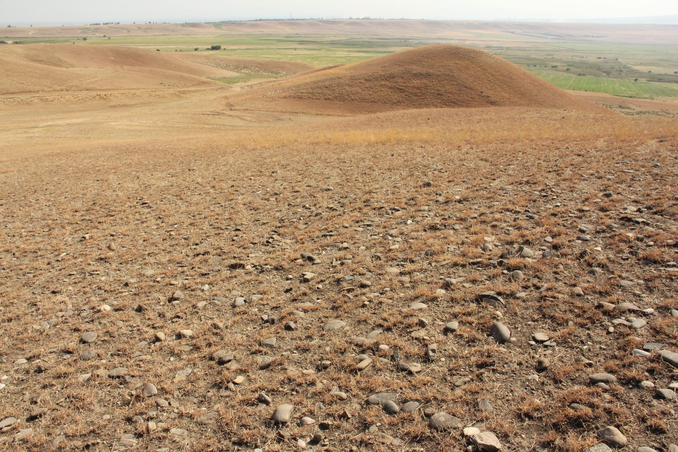
Land degradation contributes to biodiversity loss and the impoverishment of rural livelihoods in Tusheti. Above all, however, land degradation are triggered by climate change as traditional land use practise might not be adapted to new climate conditions which can cause or speed up degradation processes significantly. On the other hand, degraded land often leads to low biomass volumes and this reduces the ecosystem capability to stabilise local climate conditions. The concept of Land Degradation Neutrality (LDN) and the method of using remote sensing for monitoring land degradation are tools to identify the need for local planning processes. This showcase describes the LDN monitoring concept, national targets and the technology to assess indicators, mechanism and incentives for LDN.
2.2 Технологийн дэлгэрэнгүй тайлбар
Тодорхойлолт:
Purpose
The continuing global degradation of land resources threatens food security and the functioning of ecosystem services by reducing or losing their biological or economic productivity. Unsustainable land-use practices such as deforestation, overgrazing and inappropriate agricultural management systems trigger the loss and degradation of valuable land resources in Georgia. These effects are visible in all countries of the South Caucasus. About 35% of the agricultural land in Georgia is severely degraded, 60% is of low to middle production quality.
Land Degradation Neutrality (LDN)
LDN is a new international concept to combat the ongoing degradation of valuable soil resources. The LDN concept was developed by the UNCCD to encourage countries to take measures to avoid, reduce or reverse land degradation, with the vision of achieving a zero-net loss of productive land. To combat land degradation in Georgia, in 2017, the national LDN Working Group set voluntary national targets to address specific aspects of LDN, and submitted them to the UNCCD Secretariat.
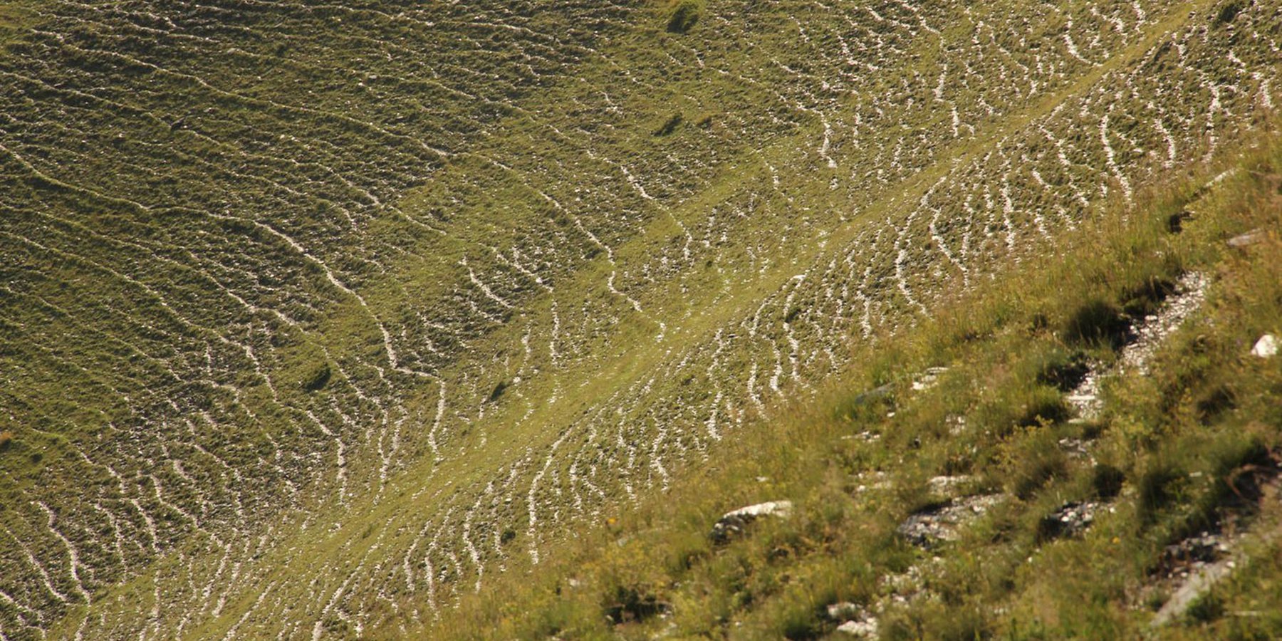
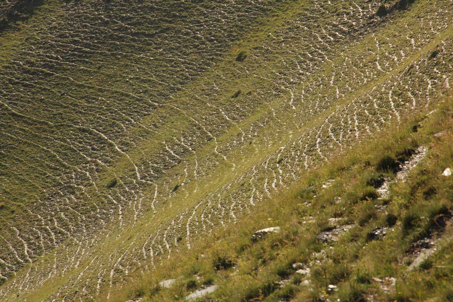
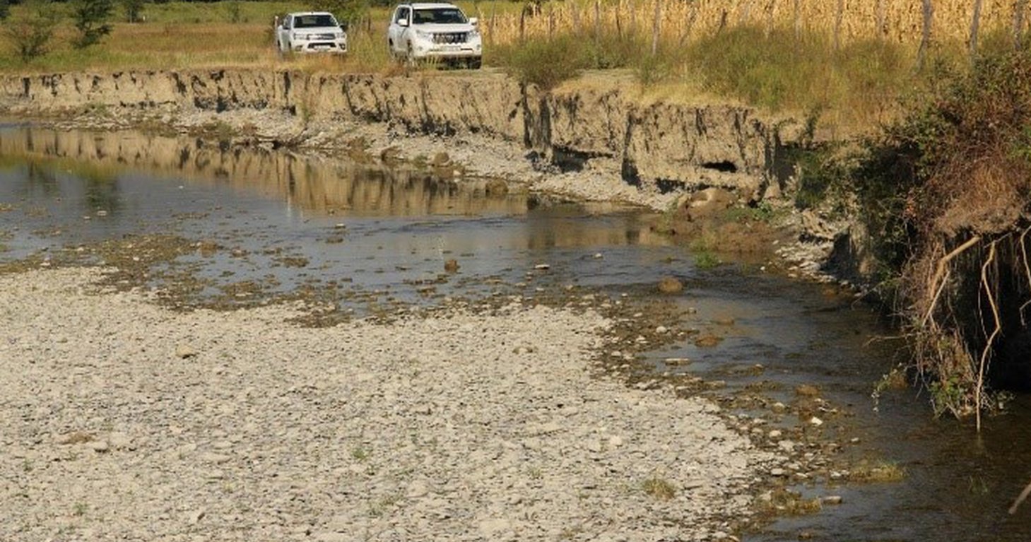
To effectively set up counter measures to combat land degradation it is important to have detailed spatial information on land cover and land cover changes as well as on trends in degradation (like size of areas effected by erosion). Therefore a remote sensing toolset was developed and tested in the pilot are of Tusheti protected landscapes in the High Caucasus in Georgia. This region shows increasing soil erosion problems by uneven distribution of grazing activities and was selected for developing erosion control measures within the Integrated Biodiversity Management in the South Caucasus Program (IBiS) funded by the Deutsche Gesellschaft für internationale Zusammenarbeit (GIZ).
Sensitivity Model
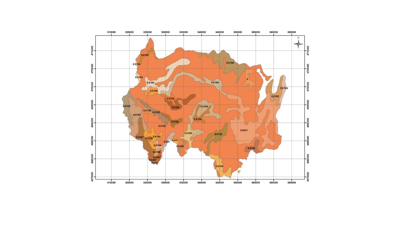
The Integrated Biodiversity Management in the South Caucasus (IBiS) project in cooperation with national experts in Georgia, developed and applied a remote sensing toolset called "Erosion Sensitivity Model". This remote sensing toolset helps to assess the current state and the general erosion risk. The sensitivity model is based on the RUSLE – Revised Universal Soil Loss Equation. The tool allows the calculation of erosion caused by rainfall and surface run-off. The RUSLE equation incorporates a combination of different input factors such as precipitation (R), soil type (K), slope (LS), vegetation cover (C) and protection measures (P). In this way, the estimated average soil loss in tonnes per acre per year (A) can be calculated as follows: A = R * K * LS * C * P.
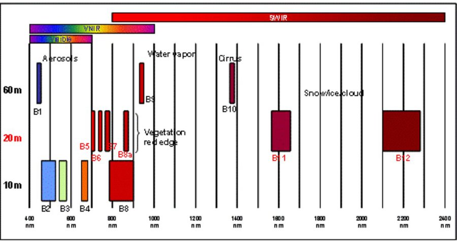
The rainfall factor (R) results from a quotient from the monthly and annual mean value of precipitation. The data come from the data platform “CHELSA – Climatologies at high resolution for the earth’s land surface areas”. For the soil type factor (K), a soil map of 1:200,000 was taken. Then, depending on the soil type, different contents of sand, silt, loam and clay were used to calculate the K factor. The slope length and steepness factor (LS) is calculated from a digital elevation model (DEM) with a raster resolution of 10x10m. The DEM is derived from the topographic map 1:25,000. The global elevation model derived from SRTM data (Shuttle Radar Topography Mission) has a resolution of 30x30 m and is available worldwide free of charge. The land cover factor (C) describes the vegetation cover that protects the soil from erosion. The vegetation cover slows down the speed of the raindrops and reduces the erosive effect of the rain. It slows down surface water runoff and stabilises the soil through root systems. The main indicators, land cover and productivity, can be assessed by remote sensing. The data from satellites need to be classified and calibrated by field data (ground truthing). The technology for the assessment of these indicators with Sentinel 2 satellite images was developed and applied in 2016 to 2018 in the Tusheti region (Akhmeta municipality) in the framework of the GIZ-IBiS project. Based on spectral information from airborne or satellite images, the density of the vegetation was calculated and mapped. There are well developed vegetation indices and classification systems to derive different land cover types and vegetation densities (mainly described by the Leaf Area Index LAI or biomass indices). The LAI is the area of the leaf surface (in square meters) per square meter ground surface. Since the real surface area of the leaves is hardly measurable, the amount of biomass is a proxy for the LAI. The P-factor is rarely considered in large-scale modelling of soil erosion risk as it is difficult to estimate it with very high accuracy. Therefore, to refine the model, a more detailed DEM (digital elevation model) is required (e.g., from satellite images). Based on the input factors, a soil erosion risk map was calculated for the whole territory of the Tusheti Protected Areas (113,660 ha). Based on the different spectral bands of the Sentinel 2 satellite image, a land cover map was calculated using the Support Vector Machine (SVM) technology and spectral image information.
The results have been integrated in the development of pasture management plans ("pasture passports"). This maps and documents are indicating areas of high erosion risk that need to be excluded from grazing and the maximum number of livestock has been calculated based on the biomass maps and will be integrated into the lease contracts.
The repetition of the remote sensing after some years (e.g. 5 years) will help to evaluate, if the measures in the pasture management have been successful to stop the degradation processes.
2.3 Технологийн гэрэл зураг
Медиа галерей
2.5 Энэ үнэлгээнд хамрагдсан технологийг хэрэгжүүлсэн улс орон / бүс нутаг / байршил
Улс :
Гүрж
Улс/аймаг/сум:
Tusheti region, Akhmeta municipality
Технологи өргөн дэлгэрсэн эсхийг тодорхойл:
- газар дээр жигд тархсан
Технологи газар нутгийн хэмжээнд жигд тархсан бол түүний эзлэх талбайг тодорхойлно уу (км2-аар):
1000.0
Технологи(иуд) нэвтрүүлсэн талбай байнгын хамгаалалттай газар нутагт байрладаг уу?
Тийм
Хэрэв тийм бол, тодруулна уу:
The area is in the Tusheti Protected Areas (Tusheti Strict Nature Reserve, Tusheti National Park, Tusheti Protected Landscape).
Тайлбар:
The whole territory was analysed by remote sensing and field records for calibration were collected on sample plots from different places in Tusheti.
Map
×2.6 Хэрэгжих огноо
Хэрэгжүүлсэн он:
2016
2.7 Технологийн танилцуулга
Технологийг хэрхэн нэвтрүүлснийг тодорхойл:
- Гадны төсөл/хөтөлбөрийн дэмжлэгтэйгээр
3. ГТМ технологийн ангилал
3.1 Технологийн үндсэн зорилго (д)
- Үйлдвэрлэлийг сайжруулах
- Газрын доройтлыг бууруулах, сэргийлэх, нөхөн сэргээх
- Биологийн төрөл зүйлийг хамгаалах / сайжруулах
- provide information to make a spatial-territorial planning
3.2 Технологи хэвтрүүлсэн газрын одоогийн газар ашиглалтын хэлбэр(д)
Нэг газр нутгийн хэмжээнд хэрэгжих холимог газар ашиглалт:
Тийм
Газар ашиглалтын холимог тогтолцоог (тарилан/бэлчээр/ой мод) тодорхойл:
- Агро-бэлчээр (тарилан-мал аж ахуйн хослуулсан тогтолцоог хамруулан ойлгоно)

Тариалангийн газар
- Нэг наст үр тариа
Тариалан - Таримлыг тодорхойлно уу:
- үр тариа - арвай
- үндсэрхэг/булцуут таримал - төмс
Нэг жил дэх ургамал ургах улирлын тоо:
- 1
Сөөлжлөн тариалалт хийгддэг үү?
Үгүй
Таримлыг ээлжлэн тариалдаг уу?
Үгүй

Бэлчээрийн газар
Нүүдлийн бэлчээр ашиглалт:
- Нүүдлийн бэлчээрийн мал аж ахуй
амьтдын төрөл зүйл:
- үхрийн аж ахуй - сүүний ба махны чиглэлийн (жишээ нь зебу)
- хонь
Тариалан-мал аж ахуйн нэгдсэн менежмент хэрэгждэг үү?
Үгүй
3.3 Технологи хэрэгжүүлснээс газар ашиглалтад өөрчлөлт гарсан уу?
Технологи хэрэгжүүлснээс газар ашиглалтад өөрчлөлт гарсан уу?
- Үгүй (3.4 хариулт руу шилжинэ үү)
3.4 Усан хангамж
бусад (жишээ нь үерийн дараах):
- rainfed and mixed rained-irrigation
3.5 Технологи ГТМ-ийн аль бүлэгт хамаарах
- Бэлчээрийн мал аж ахуй ба бэлчээрийн газрын менежмент
- гадаргын/ ургамал бүрхэвч сайжрах
3.6 Технологийг бүрдүүлэх ГТМ арга хэмжээ

Менежментийн арга хэмжээ
- М2: Ашиглалтын менежмент/эрчимийг өөрчлөх

Бусад арга хэмжээ
Тодорхойлно уу:
It is a monitoring technology to evaluate land management activities.
Тайлбар:
On some pilot plots technologies to control erosion and stop land degradation have been tested. This includes fencing, rotational pasture management, mulching and installing check dams to stop gully erosion.
3.7 Технологийн шийдвэрлэсэн газрын доройтлын үндсэн төрлүүд

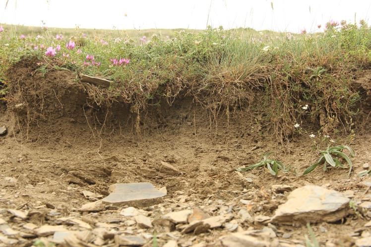
Хөрс усаар эвдрэх
- Wt: Хөрсний гадаргын угаагдал
- Wg: Гуу жалгын элэгдэл

Хөрсний физик доройтол
- Pc: Хөрс дагтарших

Биологийн доройтол
- Bc: Ургамлан нөмрөг багасах
- Bq: Хэмжээ/ Биомасс буурах
Тайлбар:
The main drivers of land degradation in the pilot area are overgrazing and trampling, off-road driving as well as infrastructure development (especially inappropriate road construction in steep slopes).
3.8 Газрын доройтлоос урьдчилан сэргийлэх, сааруулах ба нөхөн сэргээх
Газрын доройтолтой холбоотойгоор Технологи ямар зорилго тавьсан болохыг тодорхойл:
- Газрын доройтлоос урьдчилан сэргийлэх
- Газрын доройтлыг багасгах сааруулах
Тайлбар:
The monitoring tools presented here help to monitor the development of land degradation and to evaluate measures and development trends.
4. Техникийн нөхцөл, хэрэгжилтийн үйл ажиллагаа, материал ба зардал
4.1 Технологийн техникийн зураг
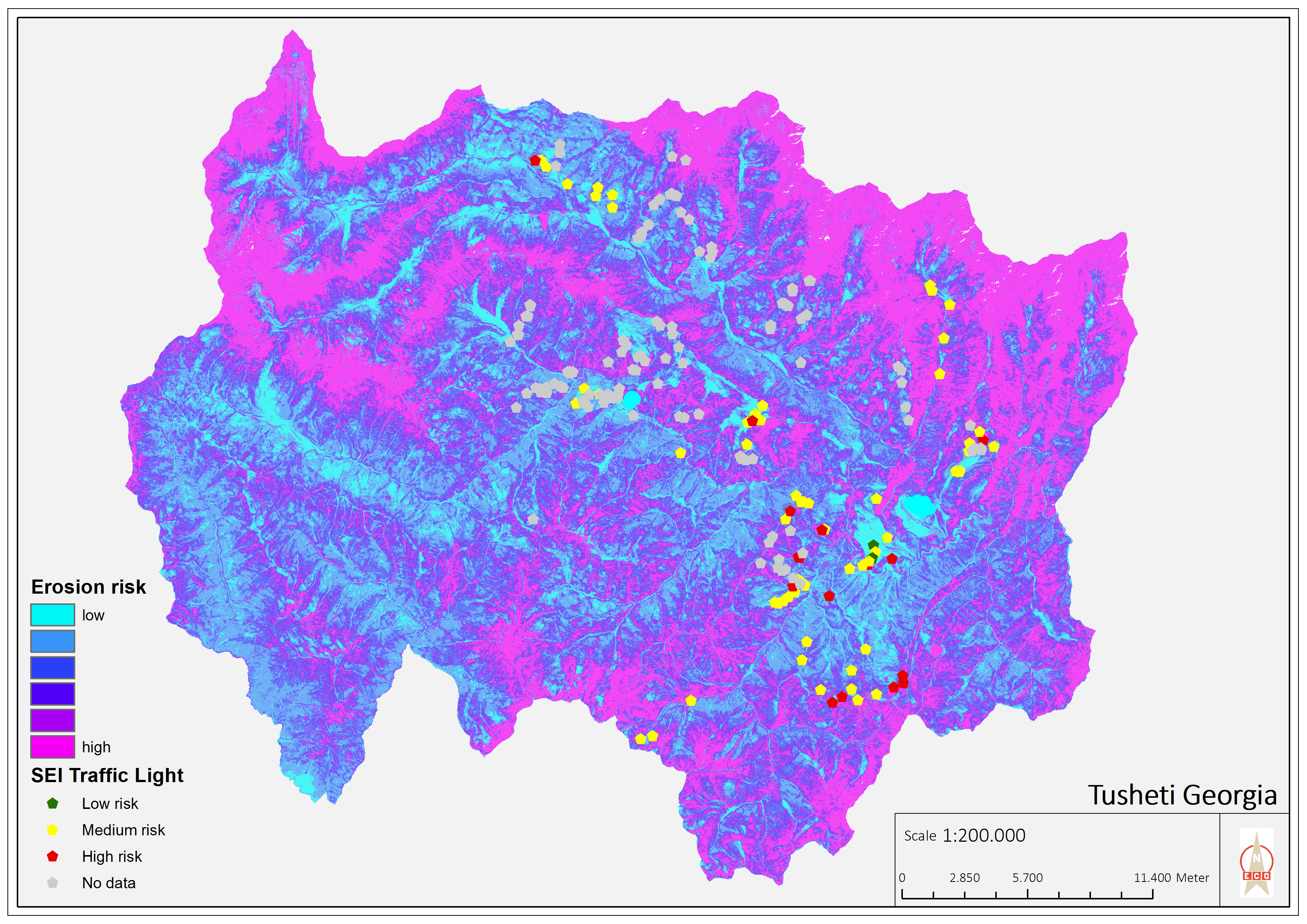
Техник тодорхойлолт (техник зурагтай уялдана):
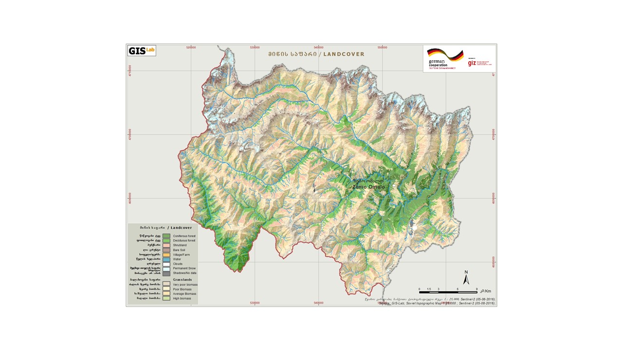
Map of erosion hot spots (pink colour) and the location of field sample plots for evaluation and ground truthing.
Зохиогч:
Hanns Kirchmeir
Он, сар, өдөр:
11/09/2019
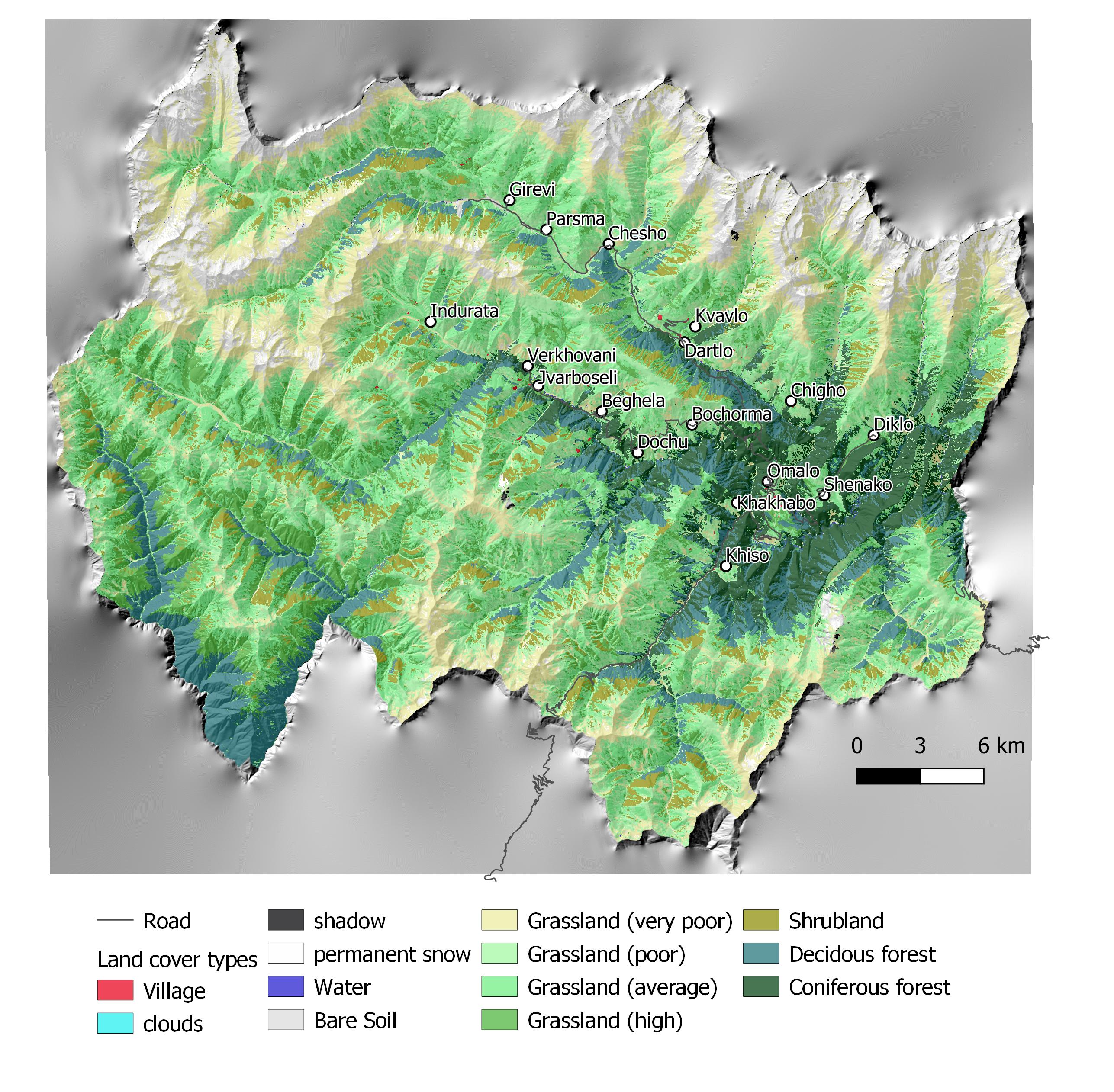
Техник тодорхойлолт (техник зурагтай уялдана):
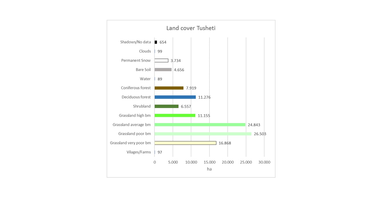
Map of land cover classification derived from satellite images. The different grassland types are classified by their biomass as an indicator of productivity and current state. Repeating the satellite image classification with the same parameters after 5 or 10 years can give a clear picture of changes in the land cover.
Зохиогч:
Hanns Kirchmeir
Он, сар, өдөр:
11/09/2019
4.2 Материал болон зардалд хамаарах ерөнхий мэдээлэл
Үнэ өртөг, оруулсан хувь нэмрийг хэрхэн тооцсоныг тодорхойл:
- Технологийн нэгж тус бүр
Хэмжээ ба нэгж талбайг тодорхойл:
1000 km2
Үнэ өртөгийг тооцоход ашигласан мөнгөн нэгж:
- Ам.доллар
Хөлсний ажилчны нэг өрдийн ажлын хөлсийг тодорхойл:
100
4.3 Байгуулах үйл ажиллагаа
| Үйл ажиллагаа | Хугацаа (улирал) | |
|---|---|---|
| 1. | National level. Baseline: Field assessment for remote sensing calibration (1x/20 years) | 2017 |
| 2. | Sentinel satellite image classification (multi temporal data from 2017) | 2017 |
| 3. | Statistical data from GEOSTAT Agricultural census | 2014-2016 |
| 4. | Analysis of soil carbon content from existing profiles | 2003 - 2006 |
| 5. | Conduct ongoing monitoring | 5 years intervals |
| 6. | Update sentinel satellite image classification | 1x year |
| 7. | Update statistical data from GEOSTAT Agricultural census | 4x/year |
| 8. | Resampling of soil carbon content near existing profiles | 1x/5 years |
| 9. | Municipal level. Spatial planning: Assessment of current stage of land degradation, anticipated gains and losses | 1x/10 years |
| 10. | Revision of spatial planning on Municipal level. | 1x / 5 years |
4.4 Байгуулалтад шаардагдах зардал ба материал
| Хөрөнгө оруулалтыг дурьдана уу | Хэмжих нэгж | Тоо хэмжээ | Нэгжийн өртөг | Материал бүрийн нийт өртөг | % газар ашиглачаас гарсан зардал | |
|---|---|---|---|---|---|---|
| Хөдөлмөр эрхлэлт | Remote Sensing analysis by Sentinel Satellite data | person days | 50.0 | 200.0 | 10000.0 | |
| Хөдөлмөр эрхлэлт | Collecting field data for satellite image callibration | person days | 40.0 | 200.0 | 8000.0 | |
| Хөдөлмөр эрхлэлт | Soil sampling (for carbon content) | person days | 20.0 | 200.0 | 4000.0 | |
| Хөдөлмөр эрхлэлт | Including results in spatial planning | person days | 10.0 | 200.0 | 2000.0 | |
| Технологи бий болгох нийт үнэ өртөг | 24000.0 | |||||
| Технологи бий болгох нийт үнэ өртөг, ам.доллар | 24000.0 | |||||
Тайлбар:
This covers the implementation of the baseline. Calibrating the model for erosion risk and land cover classification is an big investment but can be extended to larger areas than 1000 km² with similar resources.
4.5 Засвар үйлчилгээ / давтагдах үйл ажиллагаа
| Үйл ажиллагаа | Хугацаа/ давтамж | |
|---|---|---|
| 1. | Repeating the application of the calibrated remote sensing model for monitoring repitition | with 5 years interval |
| 2. | Repetition of soil samples for assessing soil carbon content | with 5 years interval |
| 3. | Analysing the results and integrate them in spatial planning and policy making | with 5 years interval |
4.6 Засвар үйлчилгээ / урсгал үйл ажиллагаанд шаардагдах зардал ба материал (жилээр)
| Хөрөнгө оруулалтыг дурьдана уу | Хэмжих нэгж | Тоо хэмжээ | Нэгжийн өртөг | Материал бүрийн нийт өртөг | % газар ашиглачаас гарсан зардал | |
|---|---|---|---|---|---|---|
| Хөдөлмөр эрхлэлт | Applying the calibrated remote sensing model for monitoring repetition | person days | 20.0 | 200.0 | 4000.0 | |
| Хөдөлмөр эрхлэлт | Repetition of soil samples for assessing soil carbon content | person days | 10.0 | 200.0 | 2000.0 | |
| Хөдөлмөр эрхлэлт | Analysing results and integrating in spatial planning | person days | 10.0 | 200.0 | 2000.0 | |
| Технологийг арчилах тордоход шаардагдах нийт үнэ өртөг | 8000.0 | |||||
| Технологи сайжруулах нийт үнэ өртөг, ам.доллар | 8000.0 | |||||
Тайлбар:
For the repetition of the remote sensing no new calibration of the GIS-model is needed. Only the field samples for soil carbon need to be repeated.
4.7 Зардалд нөлөөлж байгаа хамгийн чухал хүчин зүйл
Өртөг зардлыг тодорхойлох гол хүчин зүйлсийг дурьдана уу:
Field sample collection;
Remote sensing experts.
5. Хүн, байгалийн хүрээлэн буй орчин
5.1 Уур амьсгал
Жилийн нийлбэр хур тундас
- <250 мм
- 251-500 мм
- 501-750 мм
- 751-1,000 мм
- 1,001-1,500 мм
- 1,501-2,000 мм
- 2,001-3,000 мм
- 3,001-4,000 мм
- > 4,000 мм
Жилийн дундаж хур тунадас (хэрэв мэдэгдэж байвал), мм:
800.00
Хур тунадасны талаархи тодорхойлолт/ тайлбар:
The climate is generally suitable for agriculture with an annual precipitation of up to 800 mm, with hot and humid springs, rainfall peaks in May and June with hot and dry summers.
Агро-уур амьсгалын бүс
- Хагас чийглэг
- Хагас хуурай
5.2 Байрзүйн зураг
Дундаж налуу:
- Тэгш (0-2 %)
- Бага зэрэг хэвгий (3-5 %)
- Дунд зэрэг хэвгий (6-10 % )
- Долгиорхог (11-15 %)
- Толгодорхог (16-30 %)
- Эгц налуу (31-60 % )
- Огцом эгц налуу (>60 %)
Гадаргын хэлбэр:
- Тэгш өндөрлөг/тэгш тал
- Зоо, хяр
- Уулын энгэр, хажуу
- Ухаа, гүвээ, дов толгод
- Уулын бэл
- Хөндий, хоолой, нам хотос
Өндөршлийн бүс:
- 0-100 м д.т.д
- 101-500 м д.т.д
- 501-1,000 м д.т.д
- 1,001-1,500 м д.т.д
- 1,501-2,000 м д.т.д
- 2,001-2,500 м д.т.д
- 2,501-3,000 м д.т.д
- 3,001-4,000 м д.т.д
- > 4,000 м д.т.д
Технологи дараах асуудалд хандсан эсэхийг тодорхойл:
- шаардлагагүй
Гадаргын талаархи тайлбар ба бусад тодорхойлолт:
The remote sensing approach was applied for the total landscape of Tusheti, including a great variety of land-forms, altitudes ranging from 1600-4000 m a.s.l.
5.3 Хөрс
Хөрсний дундаж зузаан:
- Маш нимгэн (0-20 см)
- Нимгэн (21-50 см)
- Дунд зэрэг зузаан (51-80 см)
- Зузаан (81-120 cм)
- Маш зузаан (>120 cм)
Хөрсний бүтэц (өнгөн хөрс):
- Дунд зэрэг (шавранцар)
Хөрсний бүтэц (>20 см-ээс доош):
- Дунд зэрэг (шавранцар)
Өнгөн хөрсний органик нэгдэл:
- Дунд (1-3 % )
5.4 Усны хүртээм ба чанар
Хөрсний усны гүн:
Гадаргад ойрхон
Гадаргын усны хүртээмж:
Дунд зэрэг
Усны чанар (цэвэрлээгүй):
Муу чанарын ундны ус (цэвэршүүлэх шаардлагатай)
Усны чанар гэж:
гадаргын болон ул хөрсний ус
Усны давсжилт асуудал болдог уу?
Үгүй
Энэ газар үер усанд автдаг уу?
Үгүй
5.5 Биологийн төрөл зүйл
Зүйлийн олон янз байдал:
- Дунд зэрэг
Амьдрах орчны олон янз байдал:
- Их
5.6 Технологи нэвтрүүлсэн газар ашиглагчидын онцлог шинж
Суурьшмал эсвэл нүүдлийн:
- Хагас-нүүдэлчин
Үйлдвэрлэлийн системийн зах зээлийн чиг баримжаа:
- холимог (амьжиргаа ба худалдаанд)
Фермээс гадуурх орлого:
- Нийт орлогын %10 доош хувь
Чинээлэг байдлыг харьцангуй түвшин:
- Ядуу
Хувь хүн эсвэл бүлэг:
- Хувь хүн / өрх
Механикжилтын түвшин:
- Хүнд хүчир ажил
- Амьтны зүтгүүр
Хүйс:
- Эмэгтэй
- Эрэгтэй
Газар ашиглагчийн нас:
- Дунд нас
Газар ашиглагчдын бусад шаардлагатай шинж чанарыг тодорхойл:
The technology is applied by the Government.
5.7 Технологи нэвтрүүлэхэд газар ашиглагчийн ашигласан газрын дундаж талбай
- < 0.5 га
- 0.5-1 га
- 1-2 га
- 2-5 га
- 5-15 га
- 15-50 га
- 50-100 га
- 100-500 га
- 500-1,000 га
- 1,000-10,000 га
- > 10,000 га
Энэ нь жижиг, дунд, том оворт тооцогдох уу (орон нутгийн чиг баримжаагаар)?
- Дунд-хэмжээний
Тайлбар:
The pasture units are fom 200 to 600 hectares and are based on the old Soviet grazing scheme.
5.8 Газар эзэмшил, газар ашиглах эрх, ус ашиглах эрх
Газар өмчлөл:
- Төр засаг
Газар ашиглах эрх:
- Нэгдлийн хэлбэрээр (зохион байгуулалттай)
- Түрээсийн хэлбэрээр
Ус ашиглах эрх:
- Нээлттэй хүртэх (зохион байгуулалтгүй)
Газар ашиглалтын эрх уламжлалт эрхзүйн тогтолцоонд суурилдаг уу?
Үгүй
5.9 Дэд бүтэц, үйлчилгээний хүртээмж
эрүүл мэнд:
- Ядуу
- Дунд зэргийн
- Сайн
боловсрол:
- Ядуу
- Дунд зэргийн
- Сайн
техник дэмжлэг:
- Ядуу
- Дунд зэргийн
- Сайн
хөдөлмөр эрхлэлт (жишээ нь, ХАА-аас өөр):
- Ядуу
- Дунд зэргийн
- Сайн
зах зээл:
- Ядуу
- Дунд зэргийн
- Сайн
эрчим хүч:
- Ядуу
- Дунд зэргийн
- Сайн
зам ба тээвэр:
- Ядуу
- Дунд зэргийн
- Сайн
ундны ус ба ариутгал:
- Ядуу
- Дунд зэргийн
- Сайн
санхүүгийн үйлчилгээ:
- Ядуу
- Дунд зэргийн
- Сайн
6. Үр нөлөө ба дүгнэлт
6.1 Технологийн талбай дахь үр нөлөө
Экологийн үр нөлөө
Хөрс
хөрсөн бүрхэвч
Тайлбар/ тодорхой дурьдах:
Within the timeframe until 2030, specific process indicators to assess the progress will be done.
Бусад экологийн үр нөлөө
Changes in the quality of forests
Тайлбар/ тодорхой дурьдах:
tree height, stand density
Changes of the quality of pastures
Тайлбар/ тодорхой дурьдах:
biomass production
Changes in the quality of arable land
Тайлбар/ тодорхой дурьдах:
yield
Талбай дахь буюу on-site үр нөлөөний үнэлгээг тодорхойлно уу (хэмжилт):
The monitoring technology was applied for the first time to draw a baseline. Based on the results, activities have been planned and pilot measures have been implemented (exclusion from grazing, reforestation, regulation of grazing intensity). Future replications of the monitoring will show changes and evaluate success of measures. The technologies to control erosion are described separately in the WOCAT database (Community-based Erosion Control [Azerbaijan]; Pasture-weed control by thistle cutting [Georgia]; High-altitude afforestation for erosion control [Armenia]; Slope erosion control using wooden pile walls [Armenia])
6.2 Технологийн талбайн гадна үзүүлсэн үр нөлөө
Талбайн гадна буюу off-site үр нөлөөний үнэлгээг тодорхойлно уу (хэмжилт):
The technology is only about the monitoring (see above).
6.3 Технологийн уур амьсгалын өөрчлөлт ба Уур амьсгалаас хамаарах аюул/гамшигт үзэгдэлд өртөх байдал ба эмзэг байдал (газар ашиглагч нарын дүгнэлтээр)
Уур амьсгалын аажим өөрчлөлт
Уур амьсгалын аажим өөрчлөлт
| Улирал | Өсөх эсвэл буурах | Технологи түүний нөлөөг хэрхэн бууруулж байна? | |
|---|---|---|---|
| Улирлын хур тундас | Зун | Бууралт | Маш сайн |
Тайлбар:
Technology is sensitive, it shows the climate change, the impact of the global change locally. The technology itself is not affected by climatic changes.
6.4 Зардал ба үр ашгийн шинжилгээ
Үр ашгийг барилга байгууламжийн зардалтай (газар ашиглагчдын үзэл бодлоор) хэрхэн харьцуулах вэ?
Богино хугацаанд эргэн төлөгдөх байдал:
Дунд зэрэг
Урт хугацаанд эргэн төлөгдөх байдал:
Эерэг
Үр ашгийг засвар үйлчилгээ/ урсгал зардалтай (газар ашиглагчдын үзэл бодлоор) хэрхэн харьцуулах вэ?
Богино хугацаанд эргэн төлөгдөх байдал:
Дунд зэрэг
Урт хугацаанд эргэн төлөгдөх байдал:
Бага зэрэг эерэг
Тайлбар:
The monitoring technology was applied for the first time to draw a baseline. Based on the results, activities have been planned and pilot measures have been implemented (exclusion from grazing, reforestation, regulation of grazing intensity). Future replications of the monitoring will show changes and evaluate success of measures. The technologies to control erosion are described separately in the WOCAT database (Community-based Erosion Control [Azerbaijan]; Pasture-weed control by thistle cutting [Georgia]; High-altitude afforestation for erosion control [Armenia]; Slope erosion control using wooden pile walls [Armenia]).
The costs of the remote sensing approach have not been invested by the land owners but by GIZ and the Ministry. Therefore there are no direct negative impact caused by the investment. The maintenance will be covered by public authorities as well. The positive impact for the land users are the clearly delineated pasture unit giving the exact area of grassland and the accessible amount of fodder biomass. By this, the lease-rate can be found according to the productivity and the number of livestock can be adapted to the carrying capacity of the land within the lease contract.
6.5 Технологи нутагшуулах
- жишээ/ туршилт
Боломжтой бол, тоогоор илэрхийл (өрхийн тоо эсвэл бүрхэх талбай):
The technology is desigend to be applied by national or regional addministrations and not by land owners themselves.
6.6 Дасан зохицох
Хувьсан өөрчлөгдөж буй нөхцөл байдалд Технологид сүүлд ямар нэг шинэчлэл хийгдсэн үү?
Үгүй
6.7 Технологийн давуу тал/боломжууд
| Газар ашиглагчдын тодорхойлсон давуу тал/боломжууд |
|---|
| The monitoring technology can help to find erosion and degradation hot spots and based on this spatial information counter measures can be applied to save the productivity of land. As the income from agricultural activities and livestock breeding is of high priority in this pilot region, the protection of the productivity of land is of high importance to the local land users. |
| Эмхэтгэгч, бусад мэдээлэл өгсөн хүмүүсийн өнцгөөс тодорхойлсон давуу тал/боломжууд |
|---|
| The presented remote sensing technologies are a cost efficient and objective way to monitor land degradation and land use changes on large areas on long time periods. Based on this spatial data, land use regulations can be integrated in spatial planning and other legal and practical frameworks (e.g. pasture lease contracts) to counter act the degradation processes. The success of the measures and the development of degradation and rehabilitation can be monitored by the same toolset. |
6.8 Технологийн дутагдалтай/сул тал/аюул болон тэдгээрийн хэрхэн даван туулах арга замууд
| Газар ашиглагч нарын тодорхойлсон сул тал/ дутагдал/ эрсдэл | Тэдгээрийг хэрхэн даван туулах вэ? |
|---|---|
| The technology is complex and cannot be applied by the land user her-/himself and is sometimes hard to understand. Therefore they might mistrust in the results and are not eager to accept regulations and measures to stop degradation. | Transparent documentation of the technology and regular field visits to evaluate together with the land owners and users the remote sensing results in the field. |
| Эмхэтгэгч, бусад мэдээлэл өгсөн хүмүүсийн өнцгөөс тодорхойлсон сул тал/ дутагдал/ эрсдэл | Тэдгээрийг хэрхэн даван туулах вэ? |
|---|---|
| The institutional setup on the national level for the regular application of the remote sensing technology and the storage and management of the monitoring data is not established yet. GIS, remote sensing and soil experts are of limited availability. | Institutional capacity building and academic training courses provided at the Georgian universities can help to overcome these limitations. |
| Field data for calibration of satellite images (biomass volumes, classified land cover types, soil types, land management types) with exact information on the spatial location are rare and costly to be created. | Such data and information should be organised and gathered on national level across different sectors (agriculture, forestry, spatial planing, nature conservation ...). This would help to reduce significantly the costs and remote sensing could be applied on much larger areas. |
7. Ном зүй ба холбоосууд
7.1 Мэдээллийн аргууд / эх сурвалжууд
- Хээрийн уулзалт, судалгаа
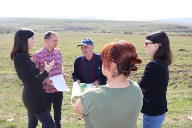
Three field visits with national and international experts as well as representatives of administrations and local stakeholders.
- Газар ашиглагчтай хийсэн ярилцлага
Meeting with cooperation partners, key village stakeholders from three pilot municipalities.
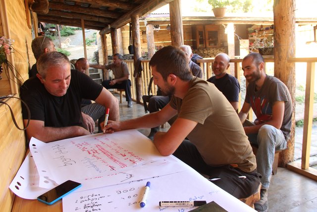
- ГТМ-ийн мэргэжилтэн/шинжээчтэй хийсэн ярилцлага
Three mission meetings with 35 experts.
- тайлан болон бусад эх сурвалжийн бүрдэл
Pilot project on land degradation neutrality in Georgia Final Report. 20.10.2017.
GISLab 2016: Development of Land Cover and Erosion Risk Map based on remote sensing for Tusheti Protected Areas. Study within the frame of GIZ-IBIS.
7.2 Хүртээмжтэй ном, бүтээлийн ишлэл
Гарчиг, зохиогч, он, ISBN:
Land Degradation Neutrality 25.10.2017
Хаанаас авч болох вэ? Зардал?
https://e-c-o.at/files/publications/downloads/D00813_ECO_policy_brief_LDN_Georgia_171025.pdf
7.3 Холбогдох мэдээллийн интернет холбоос
Гарчиг/ тодорхойлолт :
Tools for satellite image analysis
URL:
http://step.esa.int/main/snap-2-0-out-now/
Гарчиг/ тодорхойлолт :
UNCCD Good Practice Guidance on SDG Indicator 15.31. (Sims et al. 2017)
URL:
https://www.unccd.int/sites/default/files/relevant-links/2017-10/Good%20Practice%20Guidance_SDG%20Indicator%2015.3.1_Version%201.0.pdf
7.4 Ерөнхий мэдээлэл
UNCCD Good Practice Guidance on SDG Indicator 15.31. (Sims et al. 2017) gives a detailed technical overview on methods and approaches to calculate LDN indicators by means of remote sensing data.
Холбоос ба модулууд
Бүгдийг харуулах Бүгдийг хаахХолбоосууд
Land Degradation Neutrality Transformative Projects and Programmes (LDN-TPP) … [Гүрж ]
In the framework of the project ‘Generating Economic and Environmental Benefits from Sustainable Land Management for Vulnerable Rural Communities of Georgia’, Land Degradation Neutrality Transformative Projects and Programmes (LDN-TPP) were developed to implement the LDN targets at municipal level. The approach defines the process to break down global and international …
- Мэдээлэл цуглуулсан: Daniel Zollner
Integrated Pasture Management Planning in Mountainous Regions [Гүрж ]
The unsustainable use of pastures and forest areas has led to soil erosion, degradation, desertification and loss of biodiversity in the high mountain areas of the South Caucasus. The development of pasture passports is part of a broader approach to a strategic pasture management plan for Tusheti. This showcase includes …
- Мэдээлэл цуглуулсан: Hanns Kirchmeir
Модулууд
Модуль байхгүй байна